August 2, 2021
Location: 28 miles northeast of Klamath Falls
Fireline total: 323 miles (51 miles active fire edge and 272 miles of contained line)
Size: 413,762 acres or 647 square miles
Personnel: 1,780
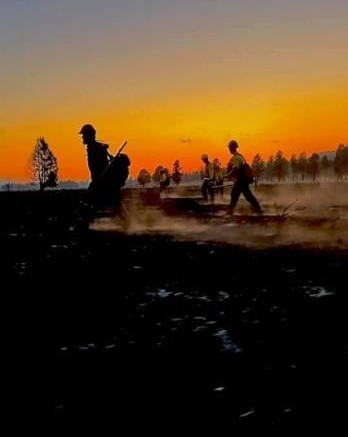
KLAMATH FALLS, Ore. – Crews on Sunday reported smokes from smoldering and torching fuels inside the burn area as they widened the fire line and soaked remaining heat and flames. Dozers continue to straighten the ragged edge of the fire line on the east side for improved containment. If a spot fire were to start, or if the existing fire jumped the line, contingency lines are in place to stop its progression. Due to the crews’ tremendous efforts over the past few days, the percent containment has increased and the miles of active fire edge have decreased significantly.
Because of the Bootleg Fire’s size and local conditions, it still holds a lot of heat. Even though progress has been made and fire advisors are confident in the containment measures, severe conditions remain for fire hazard. “Megafires” like this do not usually burn out until late fall or early winter when moisture increases and temperature decreases.
“For local residents, warm, dry, windy weather in this area is not a surprise,” said Tom Wright, Incident Meteorologist of the National Weather Service, Medford. “In fact, this is a common weather pattern, but it usually occurs in September—not the end of July and early August.” But this year is different. Several events led to the extremely dry conditions this year. Klamath and Lake counties are in an “exceptional” drought and have been in drought conditions for more than two years. Rainfall is at barely half the normal amount for the water year, and it is unlikely that the percentage will catch up, since the remainder of the year is the dry season. The record heat event in late June that included three consecutive days over 100 degrees Fahrenheit also had a major impact on drying trees, vegetation, and soil.
Today’s weather will include isolated afternoon showers and thunderstorms with scant amounts of rain. Over the next few days, temperatures will increase, humidity will decrease, and winds will pick up, creating critical fire weather conditions. Fuels around the fire are nearly 100% receptive to ignition if lightning strikes or an ember lands.
Evacuations: In Lake County, a Level 3 evacuation remains in place for all areas around the Bootleg Fire perimeter. The Level 3 extends to areas immediately adjacent to the fire line in all directions and includes Yamsay Mountain, Thompson Reservoir, and the Sycan Marsh to the top of Winter Rim. No evacuations are in place in Klamath County. Evacuations are dynamic; the best way to view the evacuation designation boundaries and details is on the interactive map available at tinyurl.com/bootlegevac
Red Cross Evacuation Shelters: For information or assistance: 1-800-Red-Cross (www.redcrossblog.org/disaster)
Insurance Assistance: For additional information on submitting insurance claims after losing your home or property to a wildfire, please visit https://dfr.oregon.gov/insure/home/storm/Pages/wildfires.aspx or call the state’s team of consumer advocates at 888-877-4894 (toll-free).
Closures: The Fremont-Winema National Forest is now open south of Oregon State Route 140. Closures remain in effect north of the highway to provide for public safety and the safety of firefighters. The full closure order and map are available at https://www.fs.usda.gov/alerts/fremont-winema/alerts-notices
Smoke: A change in weather patterns could start as early as tonight, as Tuesday could be a warmer, drier, and windier day than the past several. This could impact fire behavior in a way that will put more smoke into the air. Today will be generally good to moderate air quality day. This could change tonight as hazy conditions are expected. Smokier conditions close to the fire could bring back more periods when the air is Unhealthy for Sensitive Groups (USG) on Tuesday. See: fires.airfire.org/outlooks/southcentraloregon
Fire Information Public Phone: 541-482-1331 Fire Information Media Phone: 971-727-7255
Inciweb: inciweb.nwcg.gov/incident/7609/ Facebook: www.facebook.com/BootlegFireInfo
Twitter: twitter.com/BootlegFireInfo Hashtags: #BootlegFire #FireYear2021
Bootleg Fire Public Information
Email: 2021.bootleg@firenet.gov
Public Line:(541)482-1331
Media Line:(971)727-7255
August 1, 2021
Location: 28 miles NE of Klamath Falls Fireline total: 323 miles (83 miles active fire edge, 240 miles of contained line)
Size: 413,752 acres
Personnel: 1,878
KLAMATH FALLS, Ore. – Cloud cover and light rain over the last couple of days have moderated fire behavior. These favorable conditions have allowed crews on the ground, with continued air support, to make good progress on the fire line. The entire perimeter has been closed and crews are working to expand the width of the line, extinguish residual heat and flames, cut snags so they don’t roll downslope taking embers with them, and use bulldozers to straighten the ragged edge on the east side of the fire. Because there haven’t been more spot fires or breaches of the line, the Incident Management Team has been able to allocate necessary resources to focus on the active areas of the fire and strengthen the fire line.
Those efforts may be just in time. Today some isolated thunderstorms are possible, but they are more likely to bring gusty winds than rain. By Tuesday or Wednesday next week, warmer temperatures, low humidity, and gusty winds are likely to create conditions for rapid fire spread. This will be a test of the work that has been done so far to contain the fire.
“We’re not nervous about this weather,” said Karen Scholl, Operations Section Chief. “We want this test to happen to see how our line holds, while we have crews and contingencies in place. We believe we’re in a good position to be tested.”
Evacuations: In Lake County, a Level 3 evacuation remains in place for all areas around the Bootleg Fire perimeter. The Level 3 extends to areas immediately adjacent to the fire line in all directions and includes Yamsay Mountain, Thompson Reservoir, and the Sycan Marsh to the top of Winter Rim. No evacuations are in place in Klamath County. Evacuations are dynamic; the best way to view the evacuation designation boundaries and details is on the interactive map available at tinyurl.com/bootlegevac
Red Cross Evacuation Shelters: For information or assistance: 1-800-Red-Cross (www.redcrossblog.org/disaster)
Insurance Assistance: For additional information on submitting insurance claims after losing your home or property to a wildfire, please visit https://dfr.oregon.gov/insure/home/storm/Pages/wildfires.aspx or call the state’s team of consumer advocates at 888-877-4894 (toll-free).
Closures: The Fremont-Winema National Forest is now open south of Oregon State Route 140. Closures remain in effect north of the highway to provide for public safety and the safety of firefighters. The full closure order and map are available at https://www.fs.usda.gov/alerts/fremont-winema/alerts-notices
Smoke: Today should be a good day to enjoy the outdoors. Light winds should limit the spread of smoke. Overall, despite a lot of Moderate forecasts on the map, smoke levels will be on the lower end of that category. Hotter, drier, and windier conditions could start as early as Tuesday, which may have an impact on the fire’s behavior, consequently putting more smoke into the air. See: fires.airfire.org/outlooks/southcentraloregon
Bootleg Fire Public Information
Zone 1 Email: bootleg.fire.information@gmail.com
Zone 2 Email: 2021.bootleg@firenet.gov
Public Line:(541)482-1331
Media Line:(971)727-7255
July 31, 2021
Location: 28 miles northeast of Klamath Falls Size: 413,562 acres
Personnel: 1,918 Containment: 56%
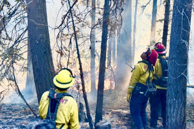
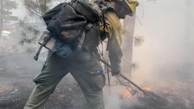
KLAMATH FALLS, Ore. – “At this point in the fire, we have to think about two things,” says Fire Behavior Analyst Chris Moore, “the fire we know about and the fire we don’t know.” The fire we know is the actively and recently burned portions of the Bootleg Fire. Much of the recent fire activity has been torching and burning pockets of fuel within the burn area. While the fire is not yet contained, a fire line has been constructed around the entire perimeter. Now crews are working to ensure that perimeter holds (is secured) to contain the fire. In some places, fire line is 100 to 150 feet wide from the unburned into the burned area. But some places may require as much as 300 feet to confidently expect the fire to remain contained.
Along the south, west, and east perimeters, crews are patrolling and extinguishing residual fire and heat (mopping up) where the fire is less active. The goal is to extend the line wide enough into the burned area to make fire escape unlikely based on the potential fire behavior, fuels, and terrain.
In the more active northwest and northeast corners of the fire, crews are working to strengthen and expand the fire line. Contingency lines, or fire breaks, further out from the perimeter, are also being constructed. The “fire we don’t know” is the potential for ember-sparked spot fires from these active areas or new fires sparked by lightning strikes that could occur.
Critical fire weather is forecast in the Bootleg Fire area over the weekend. Current drought conditions combined with low relative humidity, strong surface wind, and unstable air may cause more active fire behavior. In these places where the fire line is not secured, there is a potential for wind to carry embers and spark spot fires. The terrain in the northwest could encourage rapid spread of the fire and make it more difficult to control. Likewise, in the northeast corner, spot fires could continue to press up against Winter Rim and ultimately threaten structures along Summer Lake and Highway 31. Although Lake County evacuation designations have lifted, residents in this area should remain vigilant to changing fire behavior and should “Be Set” to evacuate if necessary.
A Red Flag Warning for lightning over dry fuels is in effect for Saturday afternoon and evening. Winds are expected to be light, but strong gusts and erratic winds could be associated with thunderstorms. More information is available at https://inciweb.nwcg.gov/incident/article/7609/62198/
Evacuations: Evacuations are dynamic. Klamath County has dropped all evacuation notices; however, the Fremont-Winema National Forest remains closed north of Oregon Route 140. The Lake County Sheriff’s Office and Emergency Management removed all residences in Lake County outside of the fire’s perimeter from a Level 3 evacuation. County leadership and fire teams ask that Lake County residents remain vigilant to potential wildfire hazards. In particular, areas along Highway 31 north of Monument Rock and south of the community of Summer Lake should “Be Set” to evacuate if necessary. The best way to view the evacuation designation boundaries and details is on the interactive map available at tinyurl.com/bootlegevac
Red Cross Evacuation Shelters: For information or assistance: 1-800-Red-Cross (www.redcrossblog.org/disaster)
Insurance Assistance: For additional information on submitting insurance claims after losing your home or property to a wildfire, please visit https://dfr.oregon.gov/insure/home/storm/Pages/wildfires.aspx or call the state’s team of consumer advocates at 888-877-4894 (toll-free).
Closures: The Fremont-Winema National Forest is now open south of Oregon State Route 140. Closures remain in effect north of the highway to provide for public safety and the safety of firefighters. The full closure order and map are available at https://www.fs.usda.gov/alerts/fremont-winema/alerts-notices
Smoke: Overall, today will be a generally good to moderate air quality day. Wind flow could bring in smoke from some of the neighboring fires (Jack, Dixie, and others). Models show that smoke from the Jack Fire could affect parts of Crater Late later today into tonight. Smoke from the Bootleg Fire could affect some of the eastern locations in this region, including Paisley and Silver Lake. These effects are likely to continue into tomorrow morning. See: fires.airfire.org/outlooks/southcentraloregon
Fire Information Public Phone: 541-482-1331 Fire Information Media Phone: 971-727-7255
Inciweb: inciweb.nwcg.gov/incident/7609/ Facebook: www.facebook.com/BootlegFireInfo
Twitter: twitter.com/BootlegFireInfo Hashtags: #BootlegFire #FireYear2021
July 30, 2021
Location: 28 miles northeast of Klamath Falls, OR Size: 413,545 acres
Personnel: 1,928 Containment: 53%
WALLOWA, Ore. – The water is flowing across all divisions of the Elbow Creek Fire 17 miles northwest of Wallowa. Fire crews have fully transitioned to mop-up and an increase in the number of water tenders will keep the water flowing to help firefighters soak the remains of the fire over the next several days.
The fire is 22,955 acres and 57% contained.
A 10-person crew made it halfway down over the rim yesterday towards the bottom of the Grande Ronde River Canyon in the Elbow Creek drainage. They will continue to the bottom of the canyon today to seek and destroy hot spots along the river.
The depth of mop-up, or how far crews should go in from the fire’s edge, is based on the fuels and the heat they hold. Grass for instance, doesn’t hold heat for very long, and poses less of a threat of tossing embers over containment lines in coming weeks. Whereas heavier fuels, such as downed logs and stumps, can hold heat for weeks and even months. Areas covered with heavier fuels may require up to 300 feet to assure no burning embers carried by winds over the line.
Contingency work continues on the north side of the fire with crews improving roads and removing roadside vegetation in the event a backup fire break be needed.
Today’s weather is expected to be mostly sunny, hot, and dry with areas of smoke and haze. The high will be 94-99 degrees, relative humidity 11-20 percent, and northeasterly afternoon winds from 8-12 mph with gusts to 18.
Evacuation levels within Wallowa County remain unchanged for now. Additional information on evacuation levels is available on the Wallowa County Sheriff’s Office Facebook page (www.facebook.com/Wallowa-County-Sheriffs-Office-147212815486187).
Evacuations: Evacuations are dynamic. Klamath County has dropped all evacuation notices; however, the Fremont-Winema National Forest remains closed. Evacuation levels were lowered in Lake County. The best way to view the evacuation designation boundaries and details is on the interactive map available at tinyurl.com/bootlegevac
Red Cross Evacuation Shelters: For information or assistance: 1-800-Red-Cross (www.redcrossblog.org/disaster)
Insurance Assistance: For additional information on submitting insurance claims after losing your home or property to a wildfire, please visit https://dfr.oregon.gov/insure/home/storm/Pages/wildfires.aspx or call the state’s team of consumer advocates at 888-877-4894 (toll-free).
Closures: The Fremont-Winema National Forest is closed to the public in the fire area. The full closure order and map are available at https://www.fs.usda.gov/alerts/fremont-winema/alerts-notices
Smoke: Smoke from the Dixie Fire in Northern California could once again affect the southern part of the region today. The Bootleg and other nearby fires, including the Jack Fire just to the northwest of the region, continue to impact air quality on our region. Today, we will see another good to moderate day of air quality. Periods of moderate air quality will be brief. See: fires.airfire.org/outlooks/southcentraloregon
Fire Information Public Phone: 541-482-1331 Fire Information Media Phone: 971-727-7255
Inciweb: inciweb.nwcg.gov/incident/7609/ Facebook: www.facebook.com/BootlegFireInfo
Twitter: twitter.com/BootlegFireInfo Hashtags: #BootlegFire #FireYear2021
July 29, 2021
Location: 28 miles northeast of Klamath Falls, OR Size: 413,545 acres
Personnel: 1,994
Size: 413,545 acres
Personnel: 1,994
Containment: 53%
KLAMATH FALLS, Ore. – Despite the recent rain, fire activity picked up yesterday. Fire Behavior Specialist Chris Moore commented on how unusual it is to see fire flare ups so quickly after a wetting rain. “As we move out of normal climatological range, previous experience is less relevant,” said Moore. “The rain that we got will not put the fire out. Spotting will become more of an issue as fuels dry out again.” Incident Commander Norm McDonald reinforced this caution stating that we need “a recalibration of where we are. There isn’t a ‘normal’ anymore. We need to be prepared for anything.”
Fire activity increased as the warm day dried out the fire faster and wind gusts were stronger than expected. The northwest corner remains the most active area. Dozers and hand crews are working together to close the line around that portion of the perimeter. Heavy helicopter support kept the fire cool while crews worked around Round Butte. The objective today is to hold and secure the progress made.
Two more ember-cast spot fires were identified yesterday off the northeast flank of the fire, west of Winter Rim. The spot fires were about a half mile outside the fire perimeter and small in size (less than two acres). Helicopters dropped water as air tankers made multiple retardant drops. It still requires firefighters working on the line to secure these spots. Crews will continue to take aggressive action to address any future spot fires.
The east flank of the fire remains active. That edge of the fire is a “dirty edge,” that is, there isn’t a continuous edge to the fire in this area as the fire leaves pockets of unburned vegetation. This ragged edge is more difficult for crews to secure.
In the southern portion of the fire, where activity has been relatively quiet, there were flare ups and smoke plumes visible yesterday from inside the burned area. This is a good thing. Burning fuels within the fire perimeter will help decrease the heat and chances for ember cast in the future.
Warm weather will continue through the week. Gusty winds are expected today, especially in more open areas. Yesterday a Fire Weather Watch was issued for much of the fire area through Friday. West of the fire, a Red Flag Warning is in effect through tomorrow due to thunderstorms. Scattered rain and isolated thunderstorms are possible through the weekend. More information available at https://inciweb.nwcg.gov/incident/article/7609/62198/
Evacuations: Evacuations are dynamic. Klamath County has dropped all evacuation notices; however, the Fremont-Winema National Forest remains closed. Evacuation levels are being lowered again in Lake County. The Lake County Sheriff’s Office and Emergency Management are removing all residences in Lake County outside of the fire’s perimeter from a Level 3 evacuation. Effective immediately. The best way to view the evacuation designation boundaries and details is on the interactive map available at tinyurl.com/bootlegevac
Red Cross Evacuation Shelters: For information or assistance: 1-800-Red-Cross (www.redcrossblog.org/disaster) Insurance Assistance: For additional information on submitting insurance claims after losing your home or property to a wildfire, please visit https://dfr.oregon.gov/insure/home/storm/Pages/wildfires.aspx or call the state’s team of consumer advocates at 888-877-4894 (toll-free).
Closures: The Fremont-Winema National Forest is closed to the public in the fire area. The full closure order and map are available at https://www.fs.usda.gov/alerts/fremont-winema/alerts-notices Smoke: Winds out of the southwest could blow smoke over the eastern parts of the region. The communities of Silver Lake and Paisley could see elevated air quality today. There is a chance that Silver Lake could see some of the heaviest impacts. See: fires.airfire.org/outlooks/southcentraloregon
Fire Information Public Phone: 541-482-1331
Fire Information Media Phone: 971-727-7255
Inciweb: inciweb.nwcg.gov/incident/7609/ Facebook: www.facebook.com/BootlegFireInfo
Twitter: twitter.com/BootlegFireInfo
Hashtags: #BootlegFire #FireYear2021