
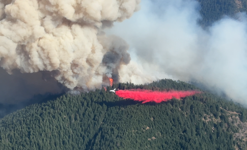
SAMS VALLEY, Ore. (July 12, 2026) – Firefighters remain engaged on the East Evans Creek Fire, continuing to hold the fire within established control lines despite active fire conditions on Sunday. Predicted wind and hot temperatures fueled an increase in fire behavior on the northwestern side, which produced a large plume of smoke over the incident. While conditions were challenging, an aggressive response from resources on the ground and in the air was successful in defending the progress made so far on the incident.
Aircraft played a large role in the success on the northwestern line today, with Large Air Tankers (LATs) and Very Large Air Tankers (VLATs) making more than 20 drops of retardant to reinforce fire lines. Helicopters aided in dropping water buckets to extinguish torching in the trees, ultimately slowing the spread of the fire.
The fire perimeter continues to be refined through on-the-ground data collection by firefighters in combination with aerial and infrared (IR) mapping. The fire is currently estimated to be 3,152 acres after an overnight infrared flight and consumption of fuels along the southern edge of the fire. Following the increased activity on the incident today, acreage may increase once again tomorrow, as the line established on the northwestern portion was not directly at the fire’s edge. Another IR flight is expected to be conducted overnight.
Oregon State Fire Marshal (OSFM) structural resources remain focused on protecting homes impacted by the fire. Throughout the day, firefighters completed mop-up operations approximately 100 feet around structures within the fire footprint, locating and extinguishing hidden sources of heat that could reignite and spread fire.
Crews also continued preparing homes by clearing flammable vegetation and debris, reducing combustible materials around structures, and improving access for firefighting resources to increase the likelihood that homes can be safely defended if fire activity increases.
In addition, structural resources conducted tactical patrols through neighborhoods near the fire’s edge, monitoring for smoke, embers, and new fire activity while quickly extinguishing hot spots that could threaten structures. Together, these efforts strengthen structural protection and reduce wildfire risk for affected communities.
Wildland firefighters continue to focus on constructing fireline directly against the fire’s edge where they can. Strategic placement of indirect fireline is being used in areas where the fire is difficult to access in an effort to hold the fire in the smallest footprint possible. On the north perimeter of the fire, equipment is being used to open roads and firelines from previous fires, with handline being constructed to connect these systems together to secure the fire.
Safety remains a priority for Oregon Department of Forestry and Oregon State Fire Marshal resources on the East Evans Creek Fire. Today there are nearly 1,000 people in fire camp including firefighters, support staff, and incident management team members. No injuries or illnesses have been reported on the incident.
Unified Command is receiving support from Pacific Power teams on the response to the East Evans Creek Fire. As people are returning to their homes, Pacific Power will continue to coordinate with the incident management team on restoring power as it is safe to do so. For more information on outage restoration times, please visit PacificPower.net/Outages.
Wildland fuels, including live vegetation, are unseasonably dry. This, in combination with continuous critical fire weather this week, including a heightened potential for lightning, is an added challenge for firefighters as they work to strengthen containment lines. Tonight’s nightshift operations will take advantage of cooler temperatures and an expected inversion to strengthen existing firelines, monitor for fire outside the established perimeter, and work on mop-up operations on the southern portion where the majority of homes are located.
The fire started on Friday afternoon at 2:41 p.m. after a car crashed into a power pole, sparking dry vegetation in the area. The Jackson County Sheriff’s Office is currently investigating the cause of the crash.
Evacuations: The Jackson County Sheriff’s Office and Emergency Management have issued the following evacuations by level:
Evacuation Level 3 Go Now: JAC-148A All residences located adjacent to E. Evans Creek Road, from address 19385 through 21899, are included in the evacuation area. Additionally, residences located at 21612 Antioch Road and 21615 Antioch Road are included.
Evacuation Level 2 Be Set:
JAC-016 / JAC-124 / JAC-147 / JAC-148B
Evacuation Level 1 Be Ready:
JAC-003 / JAC-004 / JAC-017 / JAC-026 / JAC-036 / JAC-109 / JAC-126 / JAC-149B
An evacuation shelter for residents and domestic pets has been established at Hanby Middle School, 806 6th Avenue, Gold Hill. Horses can be taken to the Expo at 21 Penninger Road, Central Point, OR. For more information on evacuation levels or to find your evacuation zone, visit https://tinyurl.com/EastEvansCreekFireEvacMap. Expo staff and volunteers are prepared to receive horses; however, please call 541‑776‑7206 first to confirm space is available, as additional shelter locations may be activated. Owners should bring feed, water containers, and any necessary medications when possible.
For livestock sheltering assistance, call 541‑776‑7206.
Road Closures: Traffic is closed to the public on East Evans Creek Road at Meadows Road. Please avoid the fire area to allow firefighters and heavy equipment to operate safely.
Temporary Flight Restriction (TFR): A “TFR” is in place for the fire area daily (24 hours) until further notice. Complete information is available at https://tfr.faa.gov/tfr3/?page=detail_6_4915. Flying a drone near or around a wildfire is illegal and compromises the safety of both pilots and firefighters, and interferes with firefighting efforts.