
ODF Complex Incident Management Teams
- ODF CIMT 1 has been mobilized to the Fielder Mountain Fire and will take command at 6 p.m. tonight. Visit the ODF Southwest Oregon District Facebook page for updates.
- ODF CIMT 2 has been mobilized to the Rowe Creek Complex and will take command Sunday, August 16. Visit the incident Facebook page for updates.
- ODF CIMT 3 is in command of the Cottonwood, Little Bear, Rosenbaum and Bologna Fire. Visit the incident Facebook page for updates.
ODF Priority Fires
| FIRE NAME | TOTAL ACRES | ODF ACRES | CONTAINMENT | LOCATION | COMMAND |
| Fielder Mountain | 550 | 225 | 0% | 4 miles SE of Grants Pass | ODF CIMT 1 (TOC @ 1800) |
| Cottonwood | 722 | 722 | 88% | 15 miles SW of Long Creek | ODF CIMT 3 |
| Little Bear | 86 | 0 | 55% | 7 miles N of John Day | ODF CIMT 3 |
| Bologna | 4,743 | 1,803 | 53% | 7 miles NE of Kimberly | ODF CIMT 3 |
| Rosenbaum | 200 | TBD | 0% | 4 miles NW of Service Creek | ODF CIMT 3 |
| Rowe Creek Complex | 373,777 | 96,945 | 84% | 10 miles S of Fossil | SW Team 2 | OSFM Red Team |
| Grasshopper | 85,114 | 11,187 | 20% | 3 miles N of Sportsmans Park | SA Team 2 |
OSFM Blue Team |
| Paradise | 4,433 | 0 | 0% | 18 miles E of Milton-Freewater | NR Team 6 |
| Hagen | 54,484 | 1,486 | 11% | 26 miles E of Pendleton | NR Team 6 |
| Wrights Spring | 53,061 | 11,786 | 6% | 2 miles SE of Sprague River | NW Team 8 | OSFM Green Team |
| Shingle | 73,179 | 20,411 | 82% | 14 miles SE of Mitchell | GA Type 3 Team |
*These numbers may change as we receive more data.
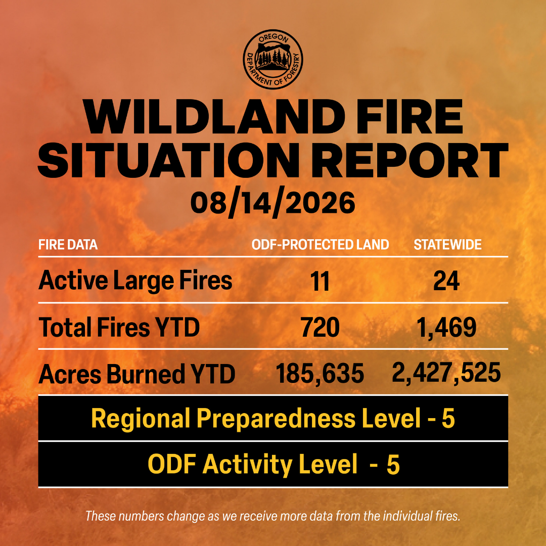
There are approximately 8,925 personnel assigned to the 24 large fires across the state, not including many of the local and agency government employees, landowners, forestland operators, and members of the community who are contributing every day.
Initial attack remains ODF’s top priority.
Prevention: As we already know, fire behavior this season is extremely active and continuously changing. Even as containment has risen on several fires, they are still experiencing fire growth, established spot fires and slopover on the containment lines. Firefighters continue to work diligently to contain these fires and will do so until it is completely out. Now is NOT the time to become complacent.
Help your wildland firefighters by preventing the next human-caused wildfire. The easiest way to do this is by checking your local fire restrictions and brushing up on your wildfire prevention knowledge. Remain aware of weather conditions and any red flag warnings in your area. Sign up for emergency alerts at ORalert.gov.
Weather: Low pressure moving south from Canada will keep thunderstorms over northern Washington and the northern Cascades through Friday, producing gusty outflow winds and localized wetting rain. Northeast winds behind a cold front will continue today across eastern Washington, with 25–35 mph gusts over higher terrain and aligned valleys and may push smoke west of the Cascades. A coastal trough will hold in place through the weekend and maintain thunder potential over northern Washington, the northern Cascades, and the Olympics. Monsoonal moisture will spread into eastern Oregon through Sunday, starting with mixed wet and dry thunderstorms and gusty outflows that shift north and gradually produce localized rainfall. Isolated thunderstorms are possible along the Oregon Cascades and the Siskiyous through Saturday, with lightning coverage potentially peaking Saturday. Weak upper waves may also trigger isolated early‑morning lightning in eastern Washington and Oregon.
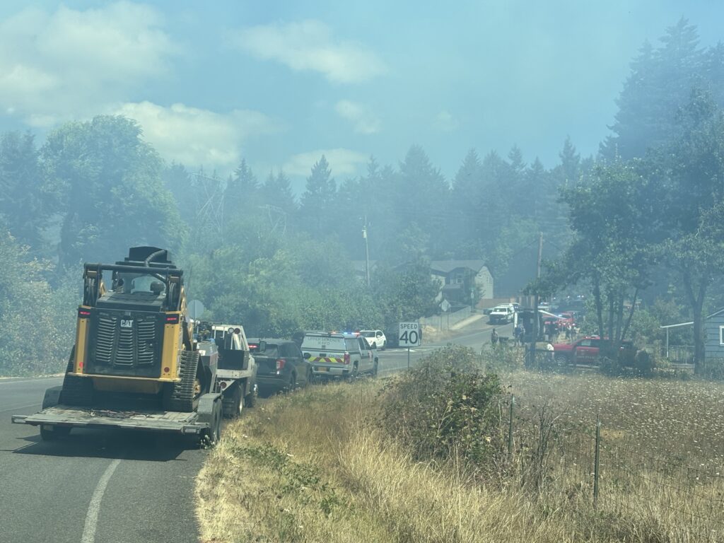 Today’s Highlight: This past Wednesday, ODF’s South Cascade District responded to a vegetation fire within the Springfield city limits. In coordination with the local fire department, ODF supported suppression efforts by providing firefighters, engines and a dozer through mutual aid agreements.
ODF alongside structural firefighters was able to help quickly extinguish the fire before it reached nearby residences.
Resources
- ODF wildfire blog and Public Fire Restrictions/Danger Levels map
- Regional situation report and national situation report
- Inciweb (information, photos, videos, and maps from specific incidents)