ODF WILDFIRE NEWS
The official wildfire news blog for the Oregon Department of Forestry
LATEST NEWS
Douglas Forest Protective Association: PUBLIC USE RESTRICTION LEVEL CHANGE: HIGH; IFPL CHANGE: LEVEL 2
JOINT NEWS RELEASE: Effective Thursday, June 29, 2023, at 12:01 am, Public Restriction Levels will change to HIGH for all private, county, state, and Bureau of Indian Affairs lands within the...

All ODF districts have entered fire season
Salem, OR – As of July 1, all Oregon Department of Forestry (ODF) districts are in fire season. This means that fire restrictions and danger levels may be in place where you live or at a destination...
Fire danger level increases to high in Western Lane and South Cascade ODF District
Eugene, Ore. – Due to high winds, low relative humidity, and high temperatures, the fire danger level on lands protected by the Oregon Department of Forestry (ODF) Western Lane and South Cascades...
Northeast Oregon public restricts implemented on ODF protected lands as wildfire risk increase
La Grande, OR – Oregon Department of Forestry’s (ODF) Northeast Oregon District will implement Regulated-Use Closure Monday, July 3rd, 2023 @ 12:01 a.m. Fire danger is increasing in northeast...
Oregon Department of Forestry begins fire season in Northeast Oregon District
La Grande, OR- A drier than normal spring and with a warming trend in the forecast has prompted Oregon Department of Forestry (ODF) to begin fire season on private forest lands in northeast Oregon....
Fire season starts in northwest Oregon
Fire season will begin in Clatsop County at 1 a.m. on Wednesday, June 14, 2023, according to the Oregon Department of Forestry. Fire season is declared each year when conditions of fire hazard...
Central Oregon District fire season begins June 9, 2023
Prineville, Ore. – Fire season on all lands protected by the Oregon Department of Forestry’s (ODF) Central Oregon District will begin June 9, 2023, at 12:01 a.m. Starting this Friday, the district’s...
Fire season begins June 1, 2023 in Jackson and Josephine counties
This Declaration Affects 1.8 Million Acres of Oregon Department of Forestry Southwest Oregon District-Protected Lands JACKSON & JOSEPHINE COUNTIES, Ore. (May 30, 2023) – Fire Season on lands...
SB 762 investments help prevent large wildfires
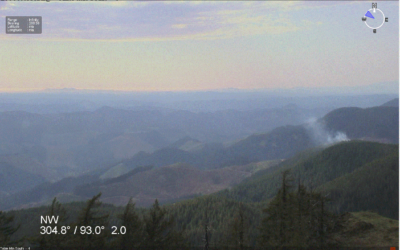
Eugene, Ore.—After several lightning strikes last night, the Oregon Department of Forestry succeeded in stopping progression on a fire between Sharps Creek and Mosby due to a detection camera...
WILDLAND FIRE STATISTICS
ODF has been protecting Oregon’s forests for 110 years, and is the largest fire department in Oregon, protecting about 16 million acres of private and public forestland. The department emphasizes the importance of preventing human-caused fires, reducing wildfire risks through improved forest health and resiliency, and keeping those fires that do start as small as possible. This approach protects lives and property and limits fire-related impacts to communities.
These stats are for lands protected by ODF only. The Northwest Interagency Coordination Center shares updated statewide and regional stats daily.
As of September 29, 2025
ODF PROTECTED LAND
Fires and acres burned
Total fires = 1,091
Total acres = 23,796
10-year average fires and acres burned
Total fires = 920
Total acres = 136,590
ALL LANDS IN OREGON
Fires and acres burned
Total fires = 2,944*
Total acres = 340,091
* ODF Fires database & NWCC SIT reconcile.
10-year average fires and acres burned**
** Requires special requests to NWCC – not on normal daily reports.
Annual Fire Reports are available through the Northwest Interagency Coordination Center (NWCC).