
July 15, 2018
|
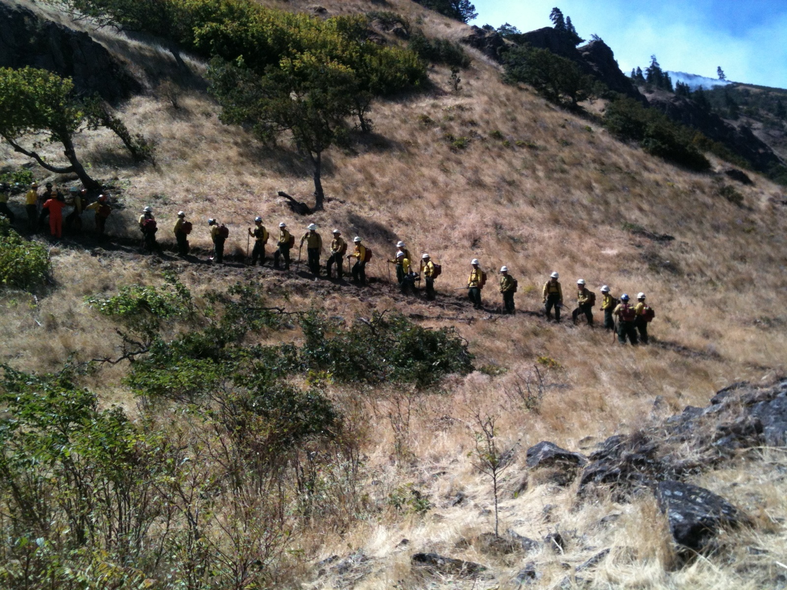
Above: Firefighters had to make their way through
dense forest Saturday to reach the Silver Creek Fire in a remote part of
Silver Falls State Park, then endure high heat. The fire size tonight
is reported at around 12 to 15 acres. |
SILVER FALLS STATE PARK, Ore. – Containment on the Silver Creek Fire inside Silver Falls State Park is reported at 10% tonight. Firefighters successfully forged trails through thick forest today to reach the fire, which is located in the Howard Creek drainage, a remote, steep area over a mile from the park boundary. Coordinated ground and air attacks made headway on the fire, which is currently estimated at 12 to 15 acres.
About 110 personnel from Oregon Department of Forestry and partner organizations are involved, with most engaged in firefighting on the ground. Aerial attack involves heavy airtankers, single-engine airtankers (SEATs), helicopter and aviation ground support.
Despite the difficult terrain and high heat Saturday, no injuries have been reported. No structures have been damaged. Park facilities remain unchanged from earlier reports:
-
The 214 Trailhead and several back-country trails, Howard Creek horse camp and day-use area, the youth camp (Camp Silver Creek) and the Ranches are all closed. Howard Creek and the Ranches are closed to serve as command posts.
-
Other areas of the park are currently operating normally, with no interruptions to scheduled events.

July 14, 2018
SILVER FALLS STATE PARK, Ore. – Oregon Department of Forestry aerial and ground resources are continuing their attack on the Silver Creek Fire this morning, with continuing close collaboration from the local Drakes Crossing Rural Fire Protection District and hand crews from the Coffee Creek Correctional Facility.
The fire’s size is estimated to be 12 acres this morning. The cause is under investigation. The fire is located in the southeast corner of Silver Falls State Park in steep, heavily timbered terrain far from roads and trails. This has made accessing the fire challenging for ground forces, who have had to clear a path to reach the fire, according to Incident Commander Brent O’Nion from ODF’s Forest Grove Unit.
The fire’s Incident Commander Brent O’Nion with ODF said this morning that, “Because the fire is in steep, heavily timbered terrain in a section of the park away from roads and trails, getting ground crews up to the fire has been challenging. Firefighter safety is a concern and our number one priority right now as we battle this blaze.”
ODF’s North Cascade District and Drakes Crossing firefighters responded to the initial report of fire Thursday night and searched until 1 a.m. trying to locate the fire but could not find any smoke column. The search resumed at daybreak Friday morning when the fire – Oregon State Parks fire closures web page.estimated at less than an acre – was finally located beneath thick timber.
Once the fire’s position was known, ODF rapidly called in air resources to help slow the fire’s spread.
“We had solid initial attack on the fire from the air yesterday, with response from a helicopter, single-engine airtankers and large airtankers,” said O’Nion. “That gave our firefighters time to work their way toward the fire so they could begin engaging on it.”
O’Nion lauded the continuing close collaboration on the fire with local firefighers and Oregon State Parks personnel.
|
Above: ODF Aviation Manger Neal Laugle
at a briefing discusses strategy on the Silver Creek Fire
with ODF fire team and local cooperators. |
Silver Falls State Park is a popular summer destination in Marion County. Oregon State Parks has closed to the public the Howard Creek Horse Campground within the park so it can be used as the staging area for firefighting operations. Camp Silver Creek (also known as Y Camp) about a mile from the fire’s location was evacuated yesterday and remains closed.
Oregon State Parks is reporting that also closed are all back-country trails on the east side of the park, The Ranches, and 214 Trailhead. The rest of the park and events there are unaffected and remain open but visitors are cautioned to be alert to firefighting activity and traffic. For the latest on park and trail closures check Oregon State Park’s fire closures web page.
# # #

July 13, 2018
SILVER FALLS STATE PARK, Ore. – Oregon Department of Forestry’s North Cascade District has responded to a small fire inside Silver Falls State Park in Marion County. The Silver Creek Fire is about a quarter acre in size. First called in last night, the fire is reported to be creeping along in heavy timber. ODF has two fire engines on scene with two 10-person hand crews en route. Two single-engine airtankers have made four retardant drops on the fire.
According to Oregon State Parks, the park remains open to visitors, including its waterfall trails. Some trails in the vicinity of the fire may be temporarily closed. Check Silver Falls State Park for the most current information.
Left: Single-engine airtankers like this one were called on today to drop retardant on a small fire in Silver Falls State Park. Two of these airtankers have dropped a total of at least four loads on the fire earlier today.

July 12, 2018
CAMP RILEA, Ore. – Wildland firefighter training wrapped up at this military training center on the Oregon coast today for some 300 Oregon National Guard members.
|
Above: ODF Protection Unit Forester Neal Bond
fires a very pistol (a type of flare gun) to start a controlled
fire at Camp Rilea, a military training center.
Oregon National Guard members practiced hands-on firefighting
techniques at the fire to get ready for this summer. |
Sixteen instructors from the Oregon Department of Forestry, Washington Department of Natural Resources, National Wildfire Suppression Association and Oregon Office of Emergency Management participated guided the Guard members through classroom and field exercises to get them ready for deployment later this summer to wildfires across the state.
Last year, more than 700 Oregon National Guard members were mobilized during the peak of fire season to help firefighters battle a number of persistent large wildfires statewide. That year, Guard members did not receive the week-long training until they were mobilized. This year, thanks to changes in how federal training funds can be used, the Guard could train before being mobilized to a wildfire.
ODF’s Deputy Chief of Fire Protection Russ Lane said several hundred other Oregon Guard troops who trained last year have completed or soon will complete required refresher training. That gives the state access to the same number of Oregon National Guard member as last year.
“By training Guard members ahead of when they will be needed, we can get Guard members to a fire about five to six days sooner than in the past,” said Lane. “That can make a huge difference in freeing up our resources to respond to other large wildfires.”
Holding the training earlier in the summer also frees up instructors during peak fire activity, Lane said, making them available to help their agencies manage wildfires.
Right: Oregon National Guard members
gather around their instructor
before a firefighting field exercise
at Camp Rilea on Oregon’s north coast.

July 10, 2018
The largest wildfire burning in Oregon at the moment is the Klamathon Fire. The fire is now estimated at 36,500 acres, of which more than 1,000 are in Oregon. Oregon Department of Forestry is in unified command of the fire with CalFire’s Siskiyou Unit and the Siskiyou County Sheriff’s Office.
The command is reporting the fire as 45% contained.
Aerial and ground attack is continuing today after good progress was made overnight, with no increase in acres burned. A major focus is preventing any further spread into Oregon. The Oregon portion of the fire is burning in the Soda Mountain Wilderness. The fire has forced closure of the Pacific Crest Trail where it passes through the wilderness. The 24,700-acre Soda Mountain Wilderness is inside the Cascade-Siskiyou National Monument and is managed by the Bureau of Land Management.
East of I-5 evacuation Levels 2 and 3 remain in place east. West of I-5 evacuation levels have decreased, with Level 3 evacuations now down to Level 2, and Level 2 orders lowered to Level 1.
About 2,800 firefighters are engaged on the wildfire, with 208 fire engines, 27 water tenders, 29 dozers, 18 helicoptes and 88 handcrews.
For more information about the fire, go to Cal Fire at http://www.fire.ca.gov/current_incidents/incidentdetails/Index/2108

July 8, 2018
Klamathon Fire – Southwest Oregon District
This fire started Thursday, July 5, in northern California on Klamathon Road. With dry and windy conditions, the fire quickly grew to over 8,000 acres in the first day and is currently estimated at 30,500 acres, with approx. 1,200 of those in Oregon. The fire
crossed the Oregon/California border about 5 miles east of I-5 early Saturday morning. ODF ground crews and aviation forces are heavily engaged and our agency is in unified command with CAL Fire and Siskiyou County Sheriff’s Office. There are currently upwards of 2,300 personnel battling the blaze.
The fire continues to threaten the communities in northern California and Colestin, Ore. Approximately 600 homes in these areas remain threatened.
Oregon evacuation notifications in Jackson County remain in place with the following areas in Jackson County are currently at a Level 3 (red) “Go” evacuation notice:
- Colestin Road area from the Oregon-California border to the Mount Ashland Ski Road.
- Highway 99 from the Oregon-California border to the Mount Ashland Ski Road.
In addition, the following areas will remain at a Level 2 (yellow) “Be Set” evacuation notice:
- Mount Ashland Ski Road from Mount Ashland down to Highway 99.
- Old Highway 99 to just below Callahan’s Lodge.
For more detailed information on the Klamathon Fire, visit: www.fire.ca.gov/current_incidents
Memaloose State Park Fire
Located ten miles east of Hood River, Oregon, the Memaloose State Park fire was reported on Friday, July 6 with the cause still under investigation. Firefighters worked on Saturday to complete fireline and have kept the fire at 65 acres. This morning the fire is 35% contained. Firefighters from Mosier Fire Department, Mid-Columbia Fire and Rescue, and the Columbia River Gorge National Scenic Area continue to assist in the suppression effort providing water tenders, fire engines and fire fighters. Today firefighters will be working to mop-up heat and flames within the fire area.
The fire threatened homes in the Rowena Dell area. Current evacuation information can be found on the Wasco County Sheriff’s facebook page: www.facebook.com/WascoCountySheriff/.
Highway 30 re-opened late Saturday, however fire activity and suppression actions can rapidly evolve, please use www.tripcheck.com to verify road closures.
Memaloose State Park is currently closed to new campers entering the campground. This closure is in place to ensure firefighter and public safety during firefighting activities. The westbound Interstate 84 Memaloose Rest Area will remain closed until repairs can be made to the electrical system which were damaged by the fire.
The fire burned lands within Memaloose State Park, Oregon Travel Experience’s Memaloose Rest Area, and private lands protected by Oregon Department of Forestry, Mid-Columbia Fire and Rescue protection, and some lands managed by the U.S. Forest Service.
Atlantic Ave Fire
|
Continued mop-up and damage
assessment are underway. |
within an hour of ignition. In addition to ODF Southwest and Fire District 3 engines, one of our Rogue Valley Structural Strike Teams was activated bringing additional assistance from
Firefighters worked overnight to complete the perimeter fire line and begin mop-up operations, keeping the fire at 115 acres burned.
Firefighters conducted a damage assessment with damages including multiple vehicles including two RVs, one bus, and six boats; four outbuildings; and one vacant residential structure have been deemed a total loss. No public, firefighter, or animal/pet injuries reported. Crews will continue working with the community in the upcoming days to assess any further damage on personal properties.
We are continuously thankful for our partnerships with our city, county, private and state agencies throughout our region, not to mention the countless community members willing to help their neighbors. Yesterday’s conditions were ripe for a wildfire that could have spread to even greater lengths. Due to the speedy and superb partnership, this fire was deemed “controlled” by nightfall.
Lobster Creek Fire
 |
The Lobster Creek Fire burned hot in a clear cut below
the road and scorched the stand of trees above |
ODF Incident Management Team 3 handed the fire back to the Coos Forest Protective Association today. After four days with no additional growth and well-established control lines, ODF Incident Management Team 3 handed the fire back to the Coos Forest Protective Association (CFPA). Fire managers are confident it poses no additional threat to life or property. with containment estimated at 75 percent.
CFPA will manage the fire with a smaller (Type 3) organization based at the Curry County Fairgrounds. Suppression strategies include additional mop up, regular engine patrols and rehabilitation efforts. The Curry County Fair will take place at the Fairgrounds as planned July 25-28.
The Lobster Creek Fire was a fast-moving wildfire driven by strong winds. It burned valuable productive timberlands protected by the Coos Forest Protective Association. Responsive efforts by state and local wildland forces kept the fire’s size under 400 acres.

July 3, 2018
|
Above: Firefighters tackle the Lobster Creek Fire 12 miles
northeast of Gold Beach in Curry County. |
GOLD BEACH, Ore. – Firefighters gained considerable ground
overnight on the Lobster Creek Fire 12 miles northeast of Gold Beach. The
wind-driven fire started Sunday afternoon on private industrial timberlands and
quickly grew to an estimated 450 acres by Monday morning. Since that time, fire
crews have nearly completed hand and bulldozer lines around the fire’s
perimeter. Current containment stands at 10 percent.
Oregon Department of Forestry’s Incident
Management Team (IMT), led by Incident Commander Link Smith, arrived Monday
afternoon to relieve Coos Forest Protective Association crews and allow them to
return to initial attack responsibilities on the district.
The IMT, comprised of 33 fire managers and
support personnel, quickly assessed the needs and began ordering additional
resources. About 450 firefighters will be working round the clock, split
between a day and night shift. Ground forces are being supported with 6
helicopters, 3 retardant-dropping Single Engine Airtankers (SEATs), 3
bulldozers, 5 engines and 5 water tenders.
The Lobster Creek Fire has been determined to
be human caused (not lightning), but remains under investigation. The fire is a
good reminder that conditions are prime for ignition and fire spread. Fire
managers are encouraging everyone to be cautious with fireworks this 4th
of July as well as any other spark-emitting activity. Fireworks are currently
prohibited in most areas. Other public fire restrictions in place include
keeping campfires in approved campgrounds and vehicles on improved roads. The
mowing of dried, cured grass, cutting and welding, and the use of power saws
are also restricted. Check with your local Oregon Department of Forestry or
forest protective association office for fire regulations in your area or where
you may be traveling.

July 2, 2018
About 150 firefighters are battling the Lobster Creek Fire today 10 miles east of Gold Beach in the Coos Forest Protective Association. Firefighters are working with fire engines, hand crews, dozers and aircraft.
The fire was reported Sunday evening, July 1. Pushed by strong winds, it spread to the south and is estimated to be 446 acres. The fire is estimated as 60% lined and 10% contained.
Oregon Department of Forestry (ODF) Incident Management Team 3 has been mobilized to take over management of the fire today at 6 p.m. This is the second IMT deployment in as many weeks. IMT 2 demobilized just last week from the Graham Fire in Central Oregon District.
The fire is burning in private industrial timberlands in the Lobster Creek and Fall Creek drainages. No homes or structures are threatened at this time.
For information on closures and fire prevention you can find Coos Forest Protective Association on the web at www.coosfpa.net, call the Closure Line at (541) 267-1789, or follow us on Facebook and Twitter.

June 27, 2018
LA GRANDE,
Ore — With the start of fire season Thursday, June 28 in the Oregon Department of
Forestry’s Northeast Oregon District, all lands protected by the state agency
will be in a declared fire season.
Forecasted
higher temperatures and drier conditions prompted ODF fire managers in the
Northeast Oregon District to declare fire season for forest and range lands
protected by ODF in Baker, Umatilla, Union and Wallowa counties along with
small portions of Malheur, Morrow, and Grant counties.
|
Above: When fire season starts June 28 in northeast Oregon,
all lands statewide protected by ODF districts and
fire protection associations will be in fire season. |
“Long range
forecasts indicate high to extreme fire danger beginning in July and extending
through September across the district,” Justin Lauer, Pendleton Wildland Fire
Supervisor said. “The light fuels in the lower elevations will cure out quickly
and carry fire readily.”
The fire
season declaration places fire prevention restrictions on landowners and the public.
Additionally, fire prevention regulations on industrial logging and forest
management activities are put into place. Lands affected include private,
state, county, municipal, and tribal lands within the Northeast Oregon Forest
Protection District. This area encompasses approximately 2 million protected
acres. The public are urged to use caution in areas of dry, cured vegetation.
Lauer stated,
“It’s easy to be complacent when we’ve had a few days of storms, but fuel
conditions and weather will change rapidly. We need everyone to use caution,
check regulations before they head out and keep an eye out for fires while
they’re out and about.”
During fire season
in northeast Oregon:
• Burn permits
for burn barrels and all open burning except camp fires are required on all
private forest and range lands within the Northeast Forest Protection District
of the Oregon Department of Forestry (ODF). Contact your local ODF office in La
Grande, Baker City, Wallowa, or Pendleton to acquire a burn permit.
• Landowners
who conducted burning of slash piles last fall and this spring are encouraged
to check the piles to ensure they are completely out and all heat is gone. It
is not uncommon for recently burned slash piles to retain heat in them for
several months after the actual burning of the piles.
• Logging and
other industrial operations must meet requirements for fire prevention, such as
fire tools, water supply, and watchman service when those operations are
occurring on lands protected by ODF. Contact your local Stewardship Forester at
any ODF office for more information.
• Campfires
must be dead out! Recreationists are reminded that campfires need to be
attended and fully extinguished before being left. Get permission from the
landowner prior to starting a campfire.
To report a
fire, dial 9-1-1.
#
# #

June 26, 2018
|
Above: Firefighters are completing control lines
and mopping up on the Graham Fire northeast of Sisters.
Over 300 personnel have been engaged on the fire,
which was stopped at 2,175 acres.
|
SISTERS, Ore. – After three days with no
additional perimeter growth and well-established control lines, the ODF
Incident Management Team 2 will be handing management of the Graham Fire in Jeffeson County back
to Oregon Department of Forestry’s Central Oregon District Wednesday morning, June 27. Control
lines around the fire’s perimeter have been mopped up to at least 50 feet.
However, local residents may still expect to see occasional smoke from pockets
of unburnt fuel smoldering in the fire’s interior. If residents see flames or
spot fires they are advised to call 911.
Resources on the fire today
include: 10 hand crews, 2 helicopters, 17 engines, 1 dozer, 3 water tenders and
338 personnel. Containment is estimated at 85 percent
ODF’s Central Oregon District will continue
the use of additional engines and fire crews to achieve 100-percent
containment. The district strategies will include daily engine patrols and mop
up operations.
The Graham Fire was a hot,
fast-moving wildfire driven by strong winds, dry conditions and light flashy
fuels that burned in the wildland urban interface in and around the community
of Three Rivers. The firestorm torched trees and produced 100-foot flame
lengths. Thanks to the responsive efforts of local wildland and structural
suppression forces, as well as prior defensible space created by local
residents, the fire was held to 2,175 acres.
Team 2 fire managers leave behind
an excellent safety record. More than 300 personnel were assigned to the
incident and no injuries were reported.
ODF’s Central Oregon District will
continue to provide occasional updates on the fire status.
###
June 22, 2018
Private lands protected by ODF and Lake Chinook Fire and Rescue, as well as some BLM lands, are affected by the Graham Fire in central Oregon, which Gov. Brown has declared a Conflagration. The 2,055-acre Graham Fire is located in southern Jefferson County north of Sisters and south of Lake Billy Chinook. The fire was reported at around 1:30 p.m. Thursday, June 21. It is burning in an area of grass, brush and scattered juniper. Hundreds of homes are located in developments in the area. The Jefferson County Sheriff issued Level 3 evacuation orders (GO!) yesterday for many residences in the Three Rivers subdivision threatened by the fire. Those are still in effect. The threat to homes also qualifies the fire for partial reimbursement of suppression costs by FEMA.
Local firefighters have been engaged on the fire since yesterday, joined by structural teams from the Oregon Office of the State Fire Marshal. Ground forces have been aided by aerial resources including single-engine airtankers and heavy airtankers. Good progress was made overnight towards containment. The fire has burned into some complex canyon terrain, where it will take additional efforts to establish containment lines.
A Central Oregon Fire Management Service (COFMAS) Type 3 Team has been managing the wildland fire operations since last night, with the Oregon Office of the State Fire Marshal Green Team in charge of structural firefighting activities since midnight because of the threat to homes in the area.
ODF is sending its Incident Management Team 2 to the fire. The Team, headed by South Cascade District Forester Chris Cline, will arrive at 3 p.m. today for an in-briefing from the local team. The plan is for ODF to take unified command of the fire at 6 p.m. today with the OSFM Green Team.
Multiple resources are on scene and firefighters will continue to mop up around structures, flank the edge of the fire and try to contain the fire that is pushing to the northeast through Big Canyon. Additional resources have been ordered and are arriving today. Warm temperatures are anticipated in the next few days along with the return of windy conditions, which will continue to push firefighters working on the fire.
Residents and the public are reminded not to cross roadblocks into evacuation areas. Some structures may have been damaged by the fire, but due to safety concerns firefighters have not been able to investigate all areas of the fire. For further information regarding evacuations, please refer to the Jefferson County Sheriff’s Facebook site or call the Jefferson County Sheriff at 541-475-6520. Oregon State Fire Marshal is assessing properties within the fire boundary.
Statewide, there is a continuing risk of holdover fires from the recent lightning storms that passed over many parts of Oregon. Winds are expected to pick up on the east slopes of the Cascades and into the basins on the east side. With schools out and late June weekends being a traditional time when many Oregonians head for the outdoors, fires started by humans are also a cause for concern.

June 21, 2018
|
Above: Firefighters train at last year’s Interagency
Wildland Fire School, which is again being held
in Sweet Home the last week in June. |
SWEET HOME, Ore.
– Oregon Department of Forestry personnel will be among over 200 wildland firefighters and instructors convening in Sweet Home at
the end of June to take part in the annual five day Mid-Willamette Valley
Interagency Wildland Fire School. Officials from the U.S. Forest Service,
Oregon Department of Forestry (ODF), U.S Fish and Wildlife Service,
Confederated Tribes of Grand Ronde and Bureau of Land Management (BLM) are
hosting the training to prepare new firefighters for fighting fire, both in
Oregon’s forests and in rural-urban interface areas.
Co-Incident
Commanders Shawn Sheldon, Deputy Fire Staff for the BLM and Willamette
National Forest; and Craig Pettinger, Unit Forester for ODF in Sweet Home, see
fire school as an opportunity to train firefighters in both tactical skills and
safety.
“This is the 22nd
year our agencies have collaborated for this,” said Sheldon. “Fire School provides crucial education and training in wildland
fire to new firefighters and gives career firefighters a chance to refresh
their skills and explore leadership opportunities.”
Trainees will
spend the first part of the week in a classroom. Classes include basic fire
behavior, weather, map and compass use, teamwork, safety, use of engines, tools
and hose lays, fighting fire in the rural-urban interface and fire
investigation. Students will sleep in tents at Sweet Home High School and eat
meals together, giving them a taste of life in a real fire camp.
The course is capped
with a live fire exercise on Friday, June 29 just outside of Sweet Home. This
will give trainees a final challenge: applying their newly acquired skills to
suppress and mop-up a real fire.
“Cascade Timber Consulting, Inc., a local landowner, provides
a new field site each year and we are very grateful,” added Sheldon. “The live
fire exercise significantly enhances the students’ training experience –
working in smoke, hiking through uneven terrain, and working closely with crew
members to dig fireline, are all things they’ll experience this season as
wildland firefighters.”
Safety principles of fire training include wearing protective
gear, safe use of tools and being on the lookout for hazards. “Safety is
paramount in every aspect of wildland firefighting, and it begins with our
training exercises,” explained Pettinger. “Working together
in a training setting improves communications and builds effective
relationships for the agencies to draw on during fire season.”
This year, the field site that will be used for the
live fire exercise is located approximately 5 miles east of Sweet Home adjacent
to Highway 20. Fire officials are urging the public to use caution as there
will be increased fire traffic in the area and the potential for visible smoke
on Friday, June 29. For more information, please
contact Public Information Officers Chiara Cipriano, (541) 731-4427, or Jim Gersbach, (503) 945-7425.
# # #

June 21, 2018
SALEM, Ore.
— Three Oregon Department of Forestry fire protection districts from the
mid-coast through the southern Willamette Valley to the crest of the Cascades
entered fire season beginning Thursday, June 21. ODF-protected lands covered by the declaration include state,
private, county, and city forestland, as well as Bureau of Land Management
(BLM) forestlands in western Oregon.
The West Oregon, Western Lane and South Cascade districts
protect lands in Benton, Lane, Lincoln, Polk, southern Linn County and a
portion of northwest Douglas County.
An
unusually dry May and early June prompted the declarations.
|
Above; Despite recent showers, much of the southern and central
Willamette Valley and surrounding foothills are dry enough
to prompt state fire officials to declare fire season started. |
“We’ve received a
couple shots of rain recently, but that doesn’t make up for the dry spring
we’ve experienced this year. The result is that we are a couple weeks ahead of
where we traditionally are regarding fuel moistures and fire conditions in the
forest,” said Western Lane District Forester Link Smith.
Chris Cline
is district forester for ODF’s South Cascade District based in Springfield. He
said fuel moistures in eastern Lane and southern Linn counties are already
similar to what they historically would be for the beginning of July. “We look
carefully at local conditions in determining when to declare the start of fire
season. What they are telling us is that in our district it is now dry enough
for wildfires that do start to have the potential to spread more rapidly.”
As of June
20, more than 200 wildfires were reported on ODF-protected lands throughout Oregon.
These burned just over 200 acres. More than 80% of those fires were caused by
people. In light of those numbers, West Oregon District Forester Mike Totey
said, “Most wildfires at this time of year are triggered by people, so they are
almost entirely preventable with some foresight. An activity that might be low
risk when vegetation is thoroughly soaked and humidity is high could ignite a
wildfire when longer hours of sunlight, warmth and relatively light rainfall
have started drying those fuels out.”
Fire restrictions
in ODF districts vary somewhat. To find out what restrictions are in place at
any given location, go online to ODF’s statewide fire restrictions and closures
page at www.oregon.gov/ODF/Fire/Pages/Restrictions.aspx
or call the ODF office below that is nearest:
·
Western Lane (Veneta) – 541-935-2222
·
West Oregon (Philomath) – 541-929-6300 and press
1
·
South Cascade – (Springfield) – 541-726-3588 and
press 2
Six other ODF districts and
forest protective associations in southern and eastern Oregon have been in fire
season since earlier this month due to warm, dry conditions that have elevated
fire risk.
#
# #

June 21, 2018
|
Above: ODF responded overnight
to a fire high above I-84 near Mitchell Point
in the Columbia River Gorge. |
ODF’s Central Oregon District is responding to a fire that started overnight on state
parkland in the Columbia River Gorge near Mitchell Point in Hood River County. The fire is estimated at less than one
acre and is burning on steep terrain not far from the footprint of last year’s Eagle Creek Fire. Spread of the fire has been stopped. Two ODF engines are on scene along with 2 fire engines
from the Columbia River Gorge National Scenic Area and an engine each from the
City of Hood River Fire Department and the Westside Fire Department. Cause of the fire is not yet known.
The Oregon
Department of Transportation has temporarily closed the right eastbound lane of
Interstate 84 in that area. Please
use caution.

June 19, 2018
SALEM, Ore. — Gov. Kate Brown announced on June 18 a drought
emergency for Baker and Douglas counties due to low snowpack and precipitation,
low streamflows and warming temperatures. The declaration comes in the last week of spring as Oregon braces for summer wildfires.
|
Above: Spring flowers belie the fact that drought has
officially been declared in Klamath County
along with four others in eastern Oregon and
Douglas County in southern Oregon. |
Drought conditions have been intensifying in eastern Oregon, with drought emergencies already declared in Grant, Harney, Klamath and Lake counties. Douglas
County is the first county west of the Cascades to receive a drought
declaration.
“All signs point to another record-breaking drought and wildfire season for
Oregon,” Gov. Brown said. “That means we must continue our urgent work
to build communities that are ready for the challenges of climate change. I
have directed state agencies stand ready to help and work with local
communities to provide assistance.”
Forecasted water conditions are not expected to
improve, and drought is likely to have significant impacts on agriculture,
livestock, natural resources, and the local economies. Baker and Douglas
County officials requested the state to take action, and the Oregon Drought
Council considered the counties’ requests by weighing current water conditions,
future climatic forecasts, and agricultural impacts.
The Governor’s drought declaration allows increased flexibility in how water is
managed to ensure that limited supplies are used as efficiently as possible.
Oregon’s state agencies will continue to work with local governments and other
partners to coordinate efforts and mobilize actions to address drought-related
issues. The Governor’s drought declaration authorizes state agencies to
expedite water management tools to which users would not otherwise have access.
As state and local officials coordinate with federal partners, conditions will
be closely monitored by the state’s natural resource and public safety
agencies, including the Oregon Water Resources Department and the Oregon Office
of Emergency Management.
June 15, 2018
Currently, six ODF districts and fire protective associations are in fire season:
- Coos Forest Protective Association
- Douglas Forest Protective Association
- Walker Range Forest Protective Association
- Central Oregon District
- Klamath-Lake District
- Southwest Oregon District
For most Lane County residents, today (Friday, June 15) marks the last day for outdoor burning until October, according to the Lane Regional Air Protection Agency (LRAPA). The end of outdoor burning is due to elevated fire danger during the summer months. Outdoor burning is not expected to resume until the end of wildfire season this autumn.
During the closed season, yard debris may be disposed of at one of several local debris collection or recycling centers such as, Lane Forest Products, Rexius Forest By-Products, or Lane County’s transfer stations and dump sites. Composting and chipping are always encouraged and many residents in the urban growth boundaries of Eugene and Springfield also have option to use curbside yard debris pick up.
Residents who burn during the closed season are subject to violations ranging from $50 to $2,500 or more. “The average residential open burning fine runs about $300, depending upon the size of the fire and materials being burned,” said Jo Niehaus, LRAPA Spokesperson. “Illegal burning during the dry summer months also increases the risk of wildfires that can damage property and destroy homes.”
Backyard debris burning – which includes burn piles and burn barrels – is one of the leading causes of human-caused wildfires in Oregon.
Some Lane County residents can expect to see the outdoor burning season reopen in October with a new change. Residents living inside the Eugene Urban Growth Boundary but outside the City Limits of Eugene must be on 2 acres or larger to burn in the fall.
The Lane County Fire Defense Board will decide if the season will open on time on the first of October or delay opening due to high fire risks. People can check on the season’s status by going online at www.lrapa.org or calling the LRAPA daily open burning advisory line, (541) 726-3976. Coastal residents may call (541) 997-1757.

June 6, 2018
|
Above: Firefighters across Oregon have already
been busy battling numerous small fires.
Here, firefighters from the Douglas Forest
Protective Association work to put out
the 1.5-acre Formosa Mine Fire near Riddle. |
The Douglas
Forest Protective Association, Coos Forest Protective Association and ODF’s Klamath-Lake District have announced that their 2018 fire seasons will
begin Friday, June 8. The three join the Walker Range Forest Protective Association and ODF’s Southwest and Central Oregon districts, which declared the start of their fire seasons on June 1.
The declaration of fire season imposes certain fire
restrictions on both the general public and industrial operators to help
prevent wildfires. The restrictions apply to all private, county, state, Bureau of Land Management and Bureau of Indian Affairs lands protected against fire by these entities. DFPA protects those lands in Douglas County. The Klamath-Lake District protects much of Klamath and western Lake counties in south-central Oregon. Coos FPA protects Curry, Coos and coastal portions of western Douglas County.
The start of fire season means debris burning is now prohibited. Those wishing to burn yard debris before Friday’s fire season start are encouraged to exercise caution and never leave a burn unattended. Fire officials recommend checking any debris piles that were burned earlier this year to make sure they are completely out. If not thoroughly extinguished, burn piles have the potential to smolder for weeks or even months, popping back to life on warm, windy days.
The use of exploding targets and tracer ammunition is also prohibited during fire season. Sky lanterns are prohibited year-round throughout Oregon.
Fire season also means the start of industrial fire regulations. On Friday, the entire Douglas and Coos FPAs will go into Industrial Fire Precaution Level I (one.) During IFPL I, smoking is prohibited while working on, or traveling through, an industrial operation. In addition, specified fire tools and suppression equipment must be on site and ready for use at all operations. A fire watch service is also required when work ends for the day.
In Klamath-Lake District, regulated use is in effect for lands protected by the district which are within half a mile of the Klamath River from the Keno Dam to the Oregon/California border.
As fire season progresses, additional public and industrial fire restrictions may be imposed as fire conditions become more severe.
For more information:
On lands protected by Douglas FPA:
– call their Closure Information Line at 541-672-0379 or visit www.dfpa.net
On lands protected by the Klamath-Lake District:
– for Klamath County call 541-883-5681
– for Lake County call 541-947-3311
On lands protected by Coos FPA:
– call Coos Closure Information Line at 541-267-1789 or visit www.coosfpa.net
An interactive map with statewide fire restrictions can be viewed online at https://gisapps.odf.oregon.gov/firerestrictions/PFR.html
# # #

June 5, 2018
|
Above: Smoke rises from the Chapman Grange Road No. 1 Fire.
The fire was reported Sunday and is now 100% lined.
The 42-acre fire outside Scappoose highlights how dry conditions
are for this time of year in northwest Oregon.
|
SCAPPOOSE, Ore. – Oregon Department of Forestry firefighters have finished control lines around 100% of the Chapman Grange Road No. 1 Fire seven miles northwest of Scappoose. No more growth is expected on the fire, which has been mapped at 42 acres. On Monday morning firefighters burned out 3-4 acres to tie the fire
together.
The fire was reported on Sunday afternoon , June 3 by a Life Flight helicopter taking a patient to Portland. Scappoose Rural Fire Protection District engaged in the initial attack before transferring the fire to ODF. Vernonia Rural Fire District assisted with a water tender. ODF’s Forest Grove Unit also supplied a water tender.
During the fire’s first
24 hours it actively spotted 30 to 50 feet in all directions ahead of
the flames, even on the backing side. It pushed more than 100 feet into the timber across 12-foot wide gravel roads before slowing down and burning in 5 to 6-foot
high green Douglas-fir trees.
“Those young Douglas-firs and the green underbrush burned amazingly well for this
time of year. Multiple duffy stumps in the timber within 50 feet of the
control lines were receptive to embers. Once heated, fire spread to the
surrounding vegetation even at 1 a.m.,” said ODF’s Columbia City Unit Forester Malcolm Hiatt.
According to Hiatt, along streams the fire behaved normally for what fire managers would expect in June, but in all
other fuel types the fire acted like it was the second week of August. Across much of northwest Oregon, rainfall has been only a fraction of normal for May and early June, leading to fuel moisture levels that are at or near historic lows for this date.
Working on the fire today are one Type 6 engine from Astoria and one Type 6 engine from Columbia City along with two water tenders and 4 South Fork crews. ODF also has a log loader on order to help tear apart some landing piles.
Hiatt said firefighters hope to have 50 feet mopped in on all sides by the end
of shift Tuesday. Mop up will continue for the rest of the week with a
reduction in resources starting with Wednesday’s day shift. There have been no injuries or accidents and no structures were threatened by the fire.

June 4, 2018
FOREST GROVE, Ore. — The Oregon
Department of Forestry’s Columbia City Unit is fighting a fire in logging slash
on private land about 7 miles northwest of Scappoose this morning in the
Chapman Grange Road area. No structures are threatened.
|
Above: Handcrews work on controlling a fire in logging slash on private land
about 7 miles northwest of Scappoose. The fire was reported Sunday afternoon.
|
Four hand crews from South Fork
Forest Camp, three ODF fire engines and a water tender are engaged today on the
fire, which is burning in steep, rugged terrain. About 50 personnel are
currently on site. The Chapman Road No. 1 Fire was estimated at about 30 acres
this morning. Control lines are in place around about half the fire. A
controlled burnout is being conducted to reduce fuels in the center of the fire
area.
The fire was reported Sunday, June 3 after 4 p.m. Scappoose Fire District located the fire
and provided aggressive initial attack. ODF was on scene with a joint
command structure at 6:30 p.m. Sunday, and assumed full command of the fire at
10 p.m.
Some 48 firefighters worked on the
fire through the night, including assistance from the Vernonia Rural Fire Department
and four South Fork inmate crews. Cause of the fire is under
investigation.
Before sunset Sunday, the fire was
spotting 30-50 feet away from the flame front with sustained winds of 11 miles
per hour and 50% relative humidity.
Fire managers expect the fire will
burn much of Monday as they work to contain it, making smoke visible from surrounding
communities. The area is experiencing light winds from the northwest with
a 20% chance of showers in the afternoon.
#
# #

May 31, 2018
|
Above: Dry vegetation in much of central and southern
Oregon has prompted ODF district foresters there to declare
June 1 the start of their local fire season. |
SALEM, Ore. – Starting at midnight on Friday, June 1, fire season and its associated restrictions will be in effect in the Southwest and Central Oregon districts of the Oregon Department of Forestry and the Walker Range Forest Protective Association. The declarations cover all of Jackson and Josephine counties in southern Oregon as well as Hood River and Grant counties, and portions of Crook, Deschutes, Gilliam, Harney, Jefferson, Morrow, Wasco, Wheeler and northern Klamath and northwestern Lake counties.
Local conditions dictate when fire
risk reaches the level that fire restrictions start to become warranted.
You can check whether fire season is in effect in your area and what restrictions
or closures may be in place by visiting ODF’s external website.
In announcing the start of fire
season in Central Oregon, District Forester Mike Shaw said, “Across the
district, spring has brought limited rainfall and right now we are seeing fuel
conditions drier than they were at this time last year.”
Southwest Oregon District Forester Dave Larson said, “The
district’s hope is that going into fire season on June 1st will help
curb the number of human-caused fires, especially escaped debris burn piles.”
Although the number of acres
burned so far this year has been modest, there have already been more than 130
wildfires reported on land protected by ODF. About half that total has occurred
in the districts entering fire season tomorrow.
#
# #
 |
| Smoke from wildfires |


