August 30, 2025
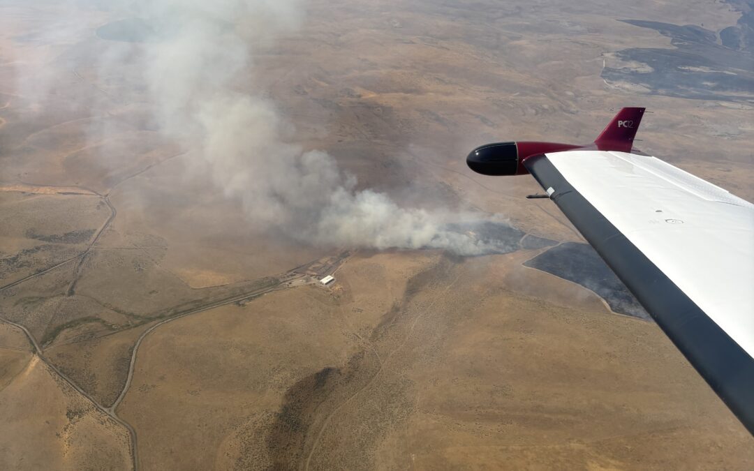
Umatilla County, Ore. – As of 6 a.m. today, the Oregon Department of Forestry’s (ODF) Northeast Oregon (NEO) District is in command of the Juniper Canyon Fire located 16 miles northeast of Hermiston. The fire is estimated to be about 9,907 acres, however that may change once more accurate mapping is completed.
The fire is burning in a mix of Bureau of Land Management administered land and unprotected private property. This required Umatilla County Emergency Management to work with Oregon Emergency Management (OEM) to activate Emergency Support Function (ESF) 4, allowing ODF to assume command of the Juniper Canyon Fire.
“This fire is a great example of strong partnerships. From the local farmers, landowners and emergency services to our federal partners, we are all working together to suppress the Juniper Canyon Fire as fast as possible while protecting nearby communities.” Justin Lauer, ODF Northeast Oregon District Forester, said.
Over the last two days, ODF’s Northeast Oregon District has been working alongside firefighters with the U.S. Forest Service to make direct attacks on the fire, using ground and aerial resources. Rough terrain and topography have made suppression efforts difficult, however significant progress has been made over the last couple of days.
“Continuing to build on our relationships with partners is always in our top priorities and yesterday was a great example with each partner contributing valuable support to the collective effort.” Lindsay Olivera, ODF Pendleton Unit Forester, said.
Thank you to the local farmer and rancher community, Umatilla County Emergency Management, the U.S. Forest Service, Oregon Emergency Management and our other local and state partners for your support as we work toward our combined goal of containment.
“The Juniper Canyon Fire shows the efficiency of the complete and coordinated fire system in Oregon and how we all have a part in protecting our beautiful communities and natural resources against wildfire.” Michael Curran, ODF Fire Protection Division Chief, said.
August 30, 2025
SISTERS, Ore. (August 30, 2025) — The Flat Fire, approximately two miles northeast of Sisters, Oregon, is estimated at 23,380 acres and is now 32% contained. After several days of challenging weather, established control lines have been tested and held strong during recent critical fire weather. Containment continues to increase steadily, a direct reflection of firefighters’ hard work, dedication, and commitment to protecting local communities and the landscape.
Overnight, wildland and structural resources identified, flagged, and addressed hot spots to aid day shift crews with mop-up operations. This coordinated approach ensures each shift is set up for success as hot, dry, and breezy conditions continue this weekend.
Today, wildland resources will continue detailed mop-up operations, while structural crews ensure fire-impacted areas around homes remain secure. Aerial resources will support firefighters by locating any visible smoke, identifying areas that may have lingering heat. On the north and northwestern part of the fire, resources have shifted to suppression repair activities. Repair work includes strategies to reduce the potential for soil erosion.
As the threat to nearby homes and other structures continues to decrease, Oregon State Fire Marshal (OSFM) will gradually transition resources back to their home agencies over the next several days. Although many resources are being released, structural protection is not ending. Firefighters continue to monitor neighborhoods and communities, watching closely for any new hot spots or flare-ups. These crews are ready to respond quickly if conditions change, ensuring that the work already done to protect homes continues to hold.
Firefighter Safety: As holiday weekend traffic increases, and more residents return to affected communities, we ask everyone to remain mindful that fire crews are still working in the area. Please drive carefully, watch for firefighting equipment on the roads, and allow crews space to do their jobs safely.
Wildfire Prevention: If your weekend plans take you outside, please be aware of the fire risks and recreate safely. Hot temperatures, low humidity, and gusty wind conditions persist in the area, naturally increasing fire risk and contributing to potential fire growth; help prevent the next wildfire by following all local regulations:
Oregon Dept. of Forestry: https://gisapps.odf.oregon.gov/firerestrictions/PFR.html
Deschutes National Forest: https://www.fs.usda.gov/…/info/public-use-restrictions
Ochoco National Forest and Crooked River National Grasslands: https://www.fs.usda.gov/r06/ochoco/alerts
Oregon/Washington BLM: https://www.blm.gov/orwafire
Evacuations: Evacuations are managed by the Deschutes County Sheriff’s Office and Jefferson County Sheriff’s Office.
Level 1 and 2 evacuations remain in effect under the direction of the Deschutes County Sheriff’s Office and the Jefferson County Sheriff’s Office. Follow their Facebook pages for the latest information and updates. They can also be reached by phone: Deschutes County Sheriff’s Office at (541) 388-6655, and Jefferson County Sheriff’s Office (541) 475-6520.
A 24-hour evacuation shelter has been set up by the Red Cross at Highland Baptist Church located at: 3100 SW Highland Ave, Redmond, OR. Jefferson County Fairgrounds in Madras and Kerley Horse Center in Powell Butte are available for large animals.
Local Area closures: To help fire operations and firefighter safety, the Bureau of Land Management and U.S. Forest Service ask that people stay out of the fire area.
The Prineville BLM has reduced the emergency closure on public lands around the fire. Steamboat Rock and Buckhorn OHV areas, as well as trails around Crooked River Ranch like Steelhead Falls, are open again.
The BLM has reduced closures, which can be found under the Prineville tab on the following page:
https://www.blm.gov/programs/public-safety-and-fire/fire-and-aviation/regional-info/oregon-washington/fire-restrictions
The U.S. Forest Service has implemented closures, which can be found on the following page: https://www.fs.usda.gov/r06/deschutes/alerts
As a reminder, drone use near fires is both illegal and extremely dangerous to pilots working on incidents. If you fly, we can’t. FAA Temporary Flight Restrictions are in place for the fire area. All illegal drone use will be reported to law enforcement.
Smoke Report: The current smoke outlook for Central Oregon can be found on the following page: https://outlooks.wildlandfiresmoke.net/outlook/6436a95d
Due to decreases in fire activity, updates will be provided once per day in the morning.
August 29, 2025
SISTERS, Ore. (August 29, 2025) — The Flat Fire is approximately two miles northeast
of Sisters, Oregon, estimated at 23,380 acres and is now 32% contained. Due to the hard work completed by firefighters, control lines held through weather events over the last few days, and containment has increased.
Critical fire weather will persist through the weekend. Hot and dry conditions, combined with variable winds and low humidity, will keep fire potential high.
Throughout the day, wildland crews monitored for smoke and completed mop-up, seeking out lingering heat, typically up to 200 feet inside the fire perimeter. Structural task forces focused on ensuring that areas around homes remained secure during afternoon winds. Air reconnaissance today showed minimal visible smoke within the fire footprint, but residual heat may remain. Nighttime infrared flights, when weather permits, help to identify these areas.
While some night shift personnel are being reassigned to daytime efforts, those continuing to work overnight will complement dayshift mop-up, patrol, and suppression repair.
With containment increasing and residents returning home, focus will continue to shift to repairing the natural environment. This work includes recontouring slopes and reducing the potential for soil erosion.
Local, state, and federal efforts remain committed to reaching full containment. Fire managers will continue thoughtfully adjusting, reducing, and reallocating resources as progress continues. “We will stay focused, stay strong, and finish this thing,” said Incident Commander Tyler McCarty with the Oregon Department of Forestry.
Firefighter Safety: As holiday weekend traffic increases, and more residents return to affected communities, we ask everyone to remain mindful that fire crews are still working in the area. Please drive carefully, watch for firefighting equipment on the roads, and allow crews space to do their jobs safely.
Wildfire Prevention: If your weekend plans take you outside, please be aware of the fire risks and recreate safely. Hot temperatures, low humidity, and gusty wind conditions persist in the area, naturally increasing fire risk and contributing to potential fire growth; help prevent the next wildfire by following all local regulations:
Oregon Dept. of Forestry: https://gisapps.odf.oregon.gov/firerestrictions/PFR.html
Deschutes National Forest: https://www.fs.usda.gov/r06/deschutes/fire/info/public-use-restrictions
Ochoco National Forest and Crooked River National Grasslands: https://www.fs.usda.gov/r06/ochoco/alerts
Oregon/Washington BLM: https://www.blm.gov/orwafire
Evacuations: Evacuations are managed by the Deschutes County Sheriff’s Office and Jefferson County Sheriff’s Office.
Level 1 and 2 evacuations remain in effect under the direction of the Deschutes County Sheriff’s Office and the Jefferson County Sheriff’s Office. Follow their Facebook pages for the latest information and updates. They can also be reached by phone: Deschutes County Sheriff’s Office at (541) 388-6655, and Jefferson County Sheriff’s Office (541) 475-6520.
A 24-hour evacuation shelter has been set up by the Red Cross at Highland Baptist Church located at: 3100 SW Highland Ave, Redmond, OR. Jefferson County Fairgrounds in Madras and Kerley Horse Center in Powell Butte are available for large animals.
Local Area closures: To help fire operations and firefighter safety, the Bureau of Land Management and U.S. Forest Service ask that people stay out of the fire area.
The BLM has implemented closures, which can be found on the following page:
https://www.blm.gov/sites/default/files/docs/2025-08/orwa-pri-flat-fire-closure-08-23-25.pdf
The U.S. Forest Service has implemented closures, which can be found on the following page: https://www.fs.usda.gov/r06/deschutes/alerts
As a reminder, drone use near fires is both illegal and extremely dangerous to pilots working on incidents. If you fly, we can’t. FAA Temporary Flight Restrictions are in place for the fire area. All illegal drone use will be reported to law enforcement.
Smoke Report: The current smoke outlook for Central Oregon can be found on the following page: https://outlooks.wildlandfiresmoke.net/outlook/6436a95d
Due to decreases in fire activity, updates will be provided once per day in the morning.
August 28, 2025
SISTERS, Ore. (August 28, 2025) — The Flat Fire, burning approximately two miles northeast of Sisters, Oregon, is estimated at 23,380 acres and is 7% contained. Acreage reflects the most current infrared (IR) flight.
Overnight, crews used IR technology to detect heat and locate hotspots up to 150 feet from the perimeter, allowing firefighters to continue targeted mop-up operations. In some areas, mop-up was extended up to 300 feet from control lines toward the interior. Near Whychus Creek Canyon, IR scans showed only minimal hotspots around homes, a direct result from work completed by both structural and wildland crews in anticipation of today and Friday’s critical fire weather.
Today, firefighters will face hot, dry conditions and gusty afternoon winds. The fire area is under a Red Flag Warning through Friday. These weather conditions will challenge the work already in place and test established lines.
Wildland crews along the south end of the fire are working inside the canyon, while structural crews are positioned to protect homes along the rim. Later today, west winds are expected to increase, bringing downslope gusts that will create hotter, drier, and more challenging conditions. West-northwest winds will reveal hidden hotspots and may revive the flames for some of the spots. In anticipation of this expected wind shift, additional resources have been moved to the south and southeastern perimeter. Structural and wildland crews are in position, ready to defend homes and at-risk areas. Firefighters remain focused on protecting the community and holding the line through this period of heightened fire weather.
Homeowners returning to the area should expect to see ongoing firefighting activity, including smoke from the fire’s interior. Smoke plumes will continue to be visible within the entire interior of the fire footprint. Structural and wildland crews are on the line 24 hours a day, focusing on strengthening containment lines and reducing hazards.
Evacuations:
Evacuations are managed by the Deschutes County Sheriff’s Office and the Jefferson County Sheriff’s Office.
Level 1, 2, and 3 evacuations remain in effect under the direction of the Deschutes County Sheriff’s Office and the Jefferson County Sheriff’s Office. Follow their Facebook pages for the latest information and updates. They can also be reached by phone: Deschutes County Sheriff’s Office at (541) 388-6655, and Jefferson County Sheriff’s Office (541) 475-6520.
A 24-hour evacuation shelter has been set up by the Red Cross at Highland Baptist Church located at: 3100 SW Highland Ave, Redmond, OR. Jefferson County Fairgrounds in Madras and Kerley Horse Center in Powell Butte are available for large animals.
Local Area closures: To help fire operations and firefighter safety, the Bureau of Land Management and U.S. Forest Service ask that people stay out of the fire area.
The BLM has implemented closures, which can be found under the Prineville tab on the following page: https://www.blm.gov/programs/public-safety-and-fire/fire-and-aviation/regional-info/oregon-washington/fire-restrictions.
The U.S. Forest Service has implemented closures, which can be found on the following page: https://www.fs.usda.gov/r06/deschutes/alerts
As a reminder, drone use near fires is both illegal and extremely dangerous to pilots working on incidents. If you fly, we can’t. FAA Temporary Flight Restrictions are in place for the fire area. All illegal drone use will be reported to law enforcement.
Local Road closures: The Deschutes County Sheriff is managing several local road closures.
· Wilt Road is open from Camp Polk to Buffalo Drive
· Wilt Road is closed at Buffalo Drive
· Mountain View Drive is closed beyond the 17700 block
· Panoramic Drive is closed at Camp Polk Road
· Goodrich Road closed north of Hwy 126
· Holmes Road closed north of Fadjur Lane
Smoke Report: The current smoke outlook for Central Oregon can be found on the following page: https://outlooks.wildlandfiresmoke.net/outlook/6436a95d?
August 28, 2025
SISTERS, Ore. (August 28, 2025) — The Flat Fire, burning approximately two miles northeast of Sisters, Oregon, is estimated at 23,380 acres and is 13% contained. Acreage reflects the most current infrared (IR) flight.
A Red Flag warning, issued by our Incident Meteorologist (IMET) for the fire area, brought hot, dry, and windy conditions today. An afternoon wind shift revealed hidden hot spots across the interior of the fire. These hot spots were well inside the fire perimeter – in some cases up to a mile inside the fire footprint.
Throughout the day, crews continued installing hose along control lines to aid in mop-up. Along the eastern edge, mop-up progressed deeper into the fire area, with crews working up to 200 feet from control lines. Along the south and southeastern perimeter of the fire, firefighters wrapped up an extensive hose lay project through steep, difficult terrain. Aerial resources surveyed the fire area, assisting crews in locating hot spots. Minimal fire activity was noted, and crews promptly addressed identified areas. On the northwest perimeter, firefighters prepared to shift towards rehabilitation work on secured sections of line.
Tonight, structural resources will continue to monitor for hot spots around homes. Wildland crews continue to utilize installed hose lines to expand mop-up inside the fire perimeter as they prepare for continued Red Flag conditions in the fire area.
Cooperative efforts have supported steady progress on the Flat Fire, especially in areas near homes and infrastructure. As a result, Deschutes and Jefferson counties have lowered evacuation levels, allowing residents to return home. “The hard work of our firefighters has allowed residents to safely return to their homes, but the work isn’t over. Crews are continuing to stabilize this incident and are working hard to increase containment,” said ODF Incident Commander Tyler McCarty.
To assist residents, structural crews are conducting outreach at homes in the immediate fire area, handing out information packets and conducting walk-arounds to help those returning home after evacuations. Structural resources continue to provide around-the-clock protection to area homes. Their continued presence ensures that local agencies remain supported as work on the fire continues. As conditions continue to stabilize and evacuation levels decrease, OSFM resources will begin returning to serve their own communities.
Firefighter Safety: With the expected increase in weekend traffic and residents returning to affected communities, we’d like to remind the public that fire crews are active in the area. Please drive cautiously and watch for equipment on the roads. If your weekend plans take you outside, please be aware of the fire risks and recreate safely. Hot temperatures, low humidity, and gusty wind conditions persist in the area, naturally increasing fire risk and contributing to potential fire growth. Please help prevent the next wildfire by following all local regulations:
Oregon Dept. of Forestry: https://gisapps.odf.oregon.gov/firerestrictions/PFR.html
Deschutes National Forest: https://www.fs.usda.gov/r06/deschutes/fire/info/public-use-restrictions
Ochoco National Forest and Crooked River National Grasslands: https://www.fs.usda.gov/r06/ochoco/alerts
Oregon/Washington BLM: https://www.blm.gov/orwafire
Evacuations: Evacuations are managed by the Deschutes County Sheriff’s Office and the Jefferson County Sheriff’s Office.
Level 1 and 2 evacuations remain in effect under the direction of the Deschutes County Sheriff’s Office and the Jefferson County Sheriff’s Office. Follow their Facebook pages for the latest information and updates. They can also be reached by phone: Deschutes County Sheriff’s Office at (541) 388-6655, and Jefferson County Sheriff’s Office (541) 475-6520.
A 24-hour evacuation shelter has been set up by the Red Cross at Highland Baptist Church located at: 3100 SW Highland Ave, Redmond, OR. Jefferson County Fairgrounds in Madras and Kerley Horse Center in Powell Butte are available for large animals.
Local Area closures: To help fire operations and firefighter safety, the Bureau of Land Management and U.S. Forest Service ask that people stay out of the fire area.
The BLM has implemented closures, which can be found under the Prineville tab on the following page: https://www.blm.gov/programs/public-safety-and-fire/fire-and-aviation/regional-info/oregon-washington/fire-restrictions.
The U.S. Forest Service has implemented closures, which can be found on the following page: https://www.fs.usda.gov/r06/deschutes/alerts
As a reminder, drone use near fires is both illegal and extremely dangerous to pilots working on incidents. If you fly, we can’t. FAA Temporary Flight Restrictions are in place for the fire area. All illegal drone use will be reported to law enforcement.
Smoke Report: The current smoke outlook for Central Oregon can be found on the following page: https://outlooks.wildlandfiresmoke.net/outlook/6436a95d?
August 27, 2025
SISTERS, Ore. (August 27, 2025) — The Flat Fire, burning approximately two miles northeast of Sisters, Oregon, is estimated at 23,261 acres and is 7% contained.
Thunderstorm activity today brought erratic, gusty winds and lightning across the fire area. On the northern edge of the fire, mop-up reached up to 100 feet in. On the eastern edge of the fire, crews continued securing line and mopping-up. Crews worked to complete a major hose lay project along dozer line in the southeastern area and expect to have it finished before night crews take over. Firefighters working in the Whychus Creek Canyon worked through steep terrain to mop-up up 150 feet in, as structure crews went house to house, extinguishing hot spots along the Canyon rim.
In the Mountain View Road area, wildland and structural resources worked side by side to coordinate mop-up 150 feet out from homes. Fallers worked along Wilt Road to remove snags to open-up access to the interior of the fire, helping firefighters to safely expand mop-up. Crews along the western perimeter pushed mop-up to several hundred feet inside. Minimal fire activity along the northwest edge allowed resources to be shifted to areas needing additional help.
Firefighters are expected to have moderate conditions overnight as they work around the clock to fortify lines. Weather conditions are expected to change as thunderstorms move north tonight, transitioning into a hot, drier pattern tomorrow with breezy western winds. These conditions will lower relative humidity and reduce overnight recoveries, contributing to challenging fire behavior. A Red Flag warning is in place tomorrow through Friday. As a result, several resources will be reassigned from night to day operations to better respond to anticipated fire behavior. Initial attack (IA) resources are ready to help local agencies address any new starts, should they occur, to allow incident personnel to continue to focus on the Flat Fire.
Evacuation levels have been updated, with several downgrades in both Jefferson and Deschutes Counties. Fire officials and law enforcement continue to monitor and re-evaluate evacuation levels, with a focus on safely returning residents to their homes. Incident officials expressed their commitment, with OSFM Red Team Incident Commander Ian Yocum stating, “Our job, our goal, is to secure the incident, to bring the residents home, and to bring the community comfort. We are committed to this incident until that goal is met.” The community is urged to stay informed by following the Jefferson and Deschutes County Sheriff’s Office Facebook pages for updates and resources to ensure a safe return home.
Evacuations:
Evacuations are managed by the Deschutes County Sheriff’s Office and the Jefferson County Sheriff’s Office.
Level 1, 2, and 3 evacuations remain in effect under the direction of the Deschutes County Sheriff’s Office and the Jefferson County Sheriff’s Office. Follow their Facebook pages for the latest information and updates. They can also be reached by phone: Deschutes County Sheriff’s Office at (541) 388-6655, and Jefferson County Sheriff’s Office (541) 475-6520.
A 24-hour evacuation shelter has been set up by the Red Cross at Highland Baptist Church located at: 3100 SW Highland Ave, Redmond, OR. Jefferson County Fairgrounds in Madras and Kerley Horse Center in Powell Butte are available for large animals.
Local Area closures: To help fire operations and firefighter safety, the Bureau of Land Management and U.S. Forest Service ask that people stay out of the fire area.
The BLM has implemented closures, which can be found under the Prineville tab on the following page: https://www.blm.gov/programs/public-safety-and-fire/fire-and-aviation/regional-info/oregon-washington/fire-restrictions.
The U.S. Forest Service has implemented closures, which can be found on the following page: https://www.fs.usda.gov/r06/deschutes/alerts
As a reminder, drone use near fires is both illegal and extremely dangerous to pilots working on incidents. If you fly, we can’t. FAA Temporary Flight Restrictions are in place for the fire area. All illegal drone use will be reported to law enforcement.
Local Road closures: The Deschutes County Sheriff is managing several local road closures.
· Wilt Road is open from Camp Polk to Buffalo Drive
· Wilt Road is closed at Buffalo Drive
· Mountain View Drive is closed beyond the 17700 block
· Panoramic Drive is closed at Camp Polk Road
· Goodrich Road closed north of Hwy 126
· Holmes Road closed north of Fadjur Lane
Smoke Report: The current smoke outlook for Central Oregon can be found on the following page: https://outlooks.wildlandfiresmoke.net/outlook/6436a95d?
August 27, 2025
SISTERS, Ore. (August 27, 2025) — The Flat Fire, burning approximately two miles northeast of Sisters, Oregon, is estimated at 23,261 acres after updated infrared (IR) mapping and is 7% contained.
Overnight, firefighters expanded upon progress made during the day. Crews improved established dozer and hand line; extended hose installations; and expanded mop-up inside the fire perimeter. Infrared (IR) was utilized by structural and wildland resources to identify and extinguish hidden hot spots near homes and around the fire perimeter.
Firefighters have been working around the clock to secure lines and prepare for hotter, drier, and windier conditions. Crews have made steady progress, strengthening established line, mopping up heat near structures, and completing miles of handline and dozer line. That work has put firefighters in a stronger position going into a period of critical fire weather. However, much remains to be done.
Warm weather, thunderstorms, and erratic winds will begin to test lines today. Gusts from the north and northwest are expected to challenge the eastern and southeastern fire line starting tomorrow.
On the eastern perimeter of the fire, foot patrols between the Flat Fire and Alder Springs burn scar continue to improve areas of line. The Lower Bridge Rangeland Fire Protection Association (RFPA) will help bolster resources along the eastern edge. RFPAs are volunteer organizations of local landowners trained to fight wildfires in rangeland areas. Structural crews will be working near Goodrich Road, extinguishing hot spots where winds have stirred up smoldering embers around homes.
On the southeastern perimeter, wildland crews continue working to complete hose lays ahead of wind that will challenge area lines. On the southwestern edge, structural and wildland resources are coordinating efforts to shore up protection of homes along the canyon rim. Along the western perimeter, crews have progressed to mopping up 150 feet inside the fire and are addressing overhead hazards caused by fire-damaged trees. Air support is available and is being utilized when needed, as weather allows.
Evacuations:
Evacuations are managed by the Deschutes County Sheriff’s Office and the Jefferson County Sheriff’s Office.
Level 1, 2, and 3 evacuations remain in effect under the direction of the Deschutes County Sheriff’s Office and the Jefferson County Sheriff’s Office. Follow their Facebook pages for the latest information and updates. They can also be reached by phone: Deschutes County Sheriff’s Office at (541) 388-6655, and Jefferson County Sheriff’s Office (541) 475-6520.
A 24-hour evacuation shelter has been set up by the Red Cross at Highland Baptist Church located at: 3100 SW Highland Ave, Redmond, OR. Jefferson County Fairgrounds in Madras and Kerley Horse Center in Powell Butte are available for large animals.
Local Area closures: To help fire operations and firefighter safety, the Bureau of Land Management and U.S. Forest Service ask that people stay out of the fire area.
The BLM has implemented closures, which can be found under the Prineville tab on the following page: https://www.blm.gov/programs/public-safety-and-fire/fire-and-aviation/regional-info/oregon-washington/fire-restrictions.
The U.S. Forest Service has implemented closures, which can be found on the following page: https://www.fs.usda.gov/r06/deschutes/alerts
As a reminder, drone use near fires is both illegal and extremely dangerous to pilots working on incidents. If you fly, we can’t. FAA Temporary Flight Restrictions are in place for the fire area. All illegal drone use will be reported to law enforcement.
Local Road closures: The Deschutes County Sheriff is managing several local road closures.
· Wilt Road is closed at Camp Polk Road
· Panoramic Drive is closed at Camp Polk Road
· Goodrich Road closed north of Hwy 126
· Holmes Road closed north of Fadjur Lane
Smoke Report: The current smoke outlook for Central Oregon can be found on the following page: https://outlooks.wildlandfiresmoke.net/outlook/6436a95d?
August 26, 2025
SISTERS, Ore. (August 26, 2025) — The Flat Fire is estimated at 23,261 acres after updated infrared (IR) mapping – with 7% containment. The fire is burning approximately two miles northeast of Sisters, Oregon.
Firefighters took advantage of cooler morning temperatures to gain ground on mop-up operations throughout the fire – even reaching 100-200 feet inside the fire, along the eastern and western perimeters. The southern end of the fire has remained the most active, and resources have shifted from other divisions to aid in the labor-intensive work needed there. Within the fire perimeter, wildland firefighters are addressing complex, patchy burn areas where fuel loads remain.
Structural resources are actively engaged with extinguishment around homes, as warm, shifting afternoon winds stir up hot spots. Fallers, specialized personnel who remove dangerous, fire-weakened trees, are working to ensure structural crews can access homes and continue mop-up operations around structures.
Overnight, crews will capitalize on cooler, more stable conditions to focus on the crucial task of securing lines ahead of the increased temperatures, winds, and decreased relative humidity expected later this week. This combination of conditions, known as critical fire weather, increases the risk for fuels to ignite, as well as the potential for torching and spotting. Firefighters are working tirelessly to complete this work ahead of the predicted weather shift.
Evacuations:
Evacuations are managed by the Deschutes County Sheriff’s Office and the Jefferson County Sheriff’s Office.
Level 1, 2, and 3 evacuations remain in effect under the direction of the Deschutes County Sheriff’s Office and the Jefferson County Sheriff’s Office. Follow their Facebook pages for the latest information and updates. They can also be reached by phone: Deschutes County Sheriff’s Office at (541) 388-6655, and Jefferson County Sheriff’s Office (541) 475-6520.
A 24-hour evacuation shelter has been set up by the Red Cross at Highland Baptist Church located at: 3100 SW Highland Ave, Redmond, OR. Jefferson County Fairgrounds in Madras and Kerley Horse Center in Powell Butte are available for large animals.
Local Area closures: To help fire operations and firefighter safety, the Bureau of Land Management and U.S. Forest Service ask that people stay out of the fire area.
The BLM has implemented closures, which can be found under the Prineville tab on the following page: https://www.blm.gov/programs/public-safety-and-fire/fire-and-aviation/regional-info/oregon-washington/fire-restrictions.
As a reminder, drone use near fires is both illegal and extremely dangerous to pilots working on incidents. If you fly, we can’t. FAA Temporary Flight Restrictions are in place for the fire area. All illegal drone use will be reported to law enforcement.
Local Road closures: The Deschutes County Sheriff is managing several local road closures.
· Wilt Road is closed at Camp Polk Road
· Panoramic Drive is closed at Camp Polk Road
· Goodrich Road closed north of Hwy 126
· Holmes Road closed north of Fadjur Lane
Smoke Report: The current smoke outlook for Central Oregon can be found on the following page: https://outlooks.wildlandfiresmoke.net/outlook/6436a95d?
August 26, 2025
SISTERS, Ore. (August 26, 2025) — The Flat Fire is estimated at 21,971 acres with 7% containment. The fire is burning approximately two miles northeast of Sisters, Oregon. Infrared (IR) flights have not been possible due to weather conditions, and updated acreage will be provided once flights can occur.
Overnight, firefighters continued to make good progress on securing fire lines. Structural crews extinguished hot spots and conducted mop-up around homes throughout the night. Dozer operators worked to improve established line, and hand crews extended mop-up operations to 50 feet inside the perimeter in many areas.
Firefighters are aggressively conducting mop-up as they prepare for a shift in weather patterns, as warm, dry, and windy conditions are expected later this week. Mop-up is when firefighters methodically secure the fire’s edge and interior. Crews search for, dig out, and extinguish burning material, such as smoldering roots, stumps, or duff, while cooling hot spots. These areas can insulate embers deep beneath the surface, smoldering out of sight. As temperatures rise and humidity drops, those embers can flare back up if they aren’t cooled. This careful work is labor-intensive but essential, helping to strengthen lines, reducing the chance that lingering heat could flare up when conditions shift later this week.
Today, wildland resources working on the north end of the fire will be installing hose lays and working to remove overhead hazards. Crews working along the eastern edge of the fire will be conducting foot patrols between the Flat Fire and Alder Springs burn scar, connecting line where needed. On the southeastern perimeter, hand crews will be installing hose lays along dozer line. On the southwestern side of the fire, firefighters continue working to secure the Whychus Creek area and will be utilizing portable pumps to assist with the cooling of hot spots along Wilt Rd. On the western edge, mop-up will be extended to 100 feet inside the fire perimeter. Structural resources are positioned within residential areas, continuing to extinguish hot spots near homes and eliminate potential for reignition.
The community may see more smoke as the weather warms this week. Fire officials ask the public to remain alert and avoid fire traffic areas to help keep crews moving safely.
Evacuations:
Evacuations are managed by the Deschutes County Sheriff’s Office and the Jefferson County Sheriff’s Office.
Level 1, 2 and 3 evacuations remain in effect under the direction of the Deschutes County Sheriff’s Office and the Jefferson County Sheriff’s Office. Follow their Facebook pages for the latest information and updates. They can also be reached by phone: Deschutes County Sheriff’s Office at (541) 388-6655, and Jefferson County Sheriff’s Office (541) 475-6520.
A 24-hour evacuation shelter has been set up by the Red Cross at Highland Baptist Church located at: 3100 SW Highland Ave, Redmond, OR. Jefferson County Fairgrounds in Madras and Kerley Horse Center in Powell Butte are available for large animals.
Local Area closures: To help fire operations and firefighter safety, the Bureau of Land Management and U.S. Forest Service ask that people stay out of the fire area. The BLM has implemented closures, which can be found under the Prineville tab on the following page: https://www.blm.gov/programs/public-safety-and-fire/fire-and-aviation/regional-info/oregon-washington/fire-restrictions.
As a reminder, drone use near fires is both illegal and extremely dangerous to pilots working on incidents. If you fly, we can’t. FAA Temporary Flight Restrictions are in place for the fire area. All illegal drone use will be reported to law enforcement.
Local Road closures: The Deschutes County Sheriff is managing several local road closures.
· Wilt Road is closed at Camp Polk Road
· Panoramic Drive is closed at Camp Polk Road
· Goodrich Road closed north of Hwy 126
· Holmes Road closed north of Fadjur Lane
Smoke Report: Air quality continues to change. For current conditions, please visit: https://fire.airnow.gov/
August 25, 2025
SISTERS, Ore. (August 25, 2025) — The Flat Fire is estimated at 21,971 acres with 5% containment. The fire is burning approximately two miles northeast of Sisters, Oregon.
Crews made significant progress today, aided by more favorable weather. Cooler temperatures and higher humidity helped stabilize conditions, allowing firefighters to shift from catching the fire to holding and securing the perimeter. Firefighters across the incident worked hard to strengthen and expand lines, and as of this evening, the fire is fully lined.
Structural strike teams remained in place within residential areas, working throughout the day to extinguish hot spots and patrol for embers. Crews have been aided in their efforts by the proactive home hardening and defensible space measures of home and property owners. These efforts, combined with the significant progress made today by wildland resources, have allowed OSFM to demobilize a local task force and a strike team this evening. These crews were part of the initial attack response and will be returning to serve their home agencies here in Central Oregon. OSFM task forces remain dedicated to the impacted area, providing structural protection around the clock.
There were decreases in evacuation levels within both Deschutes and Jefferson Counties this evening. Evacuations are managed by the Deschutes County Sheriff’s Office and the Jefferson County Sheriff’s Office. Please follow their Facebook pages for the latest updates.
While the precipitation provided some relief, fuels remain dry, and a heat advisory also continues through Wednesday, keeping conditions challenging for firefighting efforts. Tonight, firefighters will continue to improve the security of established lines ahead of expected warmer weather. Falling work to remove fire-affected trees is also underway to improve access to structures and reduce overhead dangers to firefighters.
Tonight’s public meeting was attended in person by nearly 1,000 community members. We appreciate the outpouring of support and the opportunity to connect with the community. A recording of the meeting is available on our Facebook page.
Evacuations:
Evacuations are managed by the Deschutes County Sheriff’s Office and the Jefferson County Sheriff’s Office.
Level 1, 2 and 3 evacuations remain in effect under the direction of the Deschutes County Sheriff’s Office and the Jefferson County Sheriff’s Office. Follow their Facebook pages for the latest information and updates. They can also be reached by phone: Deschutes County Sheriff’s Office at (541) 388-6655, and Jefferson County Sheriff’s Office (541) 475-6520.
A 24-hour evacuation shelter has been set up by the Red Cross at Highland Baptist Church located at: 3100 SW Highland Ave, Redmond, OR. Jefferson County Fairgrounds in Madras and Kerley Horse Center in Powell Butte are available for large animals.
Local Area closures: To help fire operations and firefighter safety, the Bureau of Land Management and U.S. Forest Service ask that people stay out of the fire area. The BLM has implemented closures, which can be found under the Prineville tab on the following page: https://www.blm.gov/programs/public-safety-and-fire/fire-and-aviation/regional-info/oregon-washington/fire-restrictions.
As a reminder, drone use near fires is both illegal and extremely dangerous to pilots working on incidents. If you fly, we can’t. FAA Temporary Flight Restrictions are in place for the fire area. All illegal drone use will be reported to law enforcement.
Local Road closures: The Deschutes County Sheriff is managing several local road closures.
· Wilt Road is closed at Camp Polk Road
· Panoramic Drive is closed at Camp Polk Road
· Goodrich Road closed north of Hwy 126
· Holmes Road closed north of Fadjur Lane
Smoke Report: Air quality continues to change. For current conditions, please visit: https://fire.airnow.gov/
August 25, 2025
SISTERS, Ore. (August 25, 2025) — As of this morning, the Flat Fire is estimated at 21,971 acres with 5% containment. The fire is burning approximately two miles northeast of Sisters, Oregon.
Last night, firefighters took advantage of reduced fire activity and cooler temperatures to make significant progress. Along the northeastern and eastern perimeter of the fire, wildland resources completed dozer line and patrolled for hot spots. On the southeastern edge, crews reinforced established line and extinguished hot spots. In the south and southwestern areas, where the fire has been very active, wildland crews were able to fully line an approximately 10-acre slop over that occurred yesterday evening. The western perimeter was fully lined utilizing dozers, as was a spot fire that occurred yesterday near the northwestern edge of the fire.
Today, crews will build upon the significant work completed during the night – holding, securing, and expanding that progress. Wildland crews will be reinforcing established line, extinguishing hot spots, and continuing to quickly attack any slop over or spot fires should they occur. Structural resources remain positioned at homes throughout threatened areas, providing point protection and extinguishing hot spots. On the north end, structure crews continue to patrol for hot spots and engage in structural protection as necessary.
Despite precipitation occurring this morning, fuels remain dry. There is a Red Flag warning through 9 pm tonight and a heat advisory remains in effect through Wednesday. There is also a chance for thunderstorms in the forecast, which could result in strong, erratic winds with gusts up to 35 mph.
The Flat Fire has unfortunately resulted in the loss of four homes and several outbuildings in Deschutes County, and our thoughts are with those impacted. While any loss is difficult, hundreds of homes in the fire’s path remain standing – reflecting both the preparation property owners put into creating defensible space and the coordinated aggressive suppression efforts. Emergency management personnel continue to assess the area and notify property owners when a damaged structure is identified. County officials will share updates if the number of damaged or destroyed structures changes.
Incident officials will host a community meeting tonight, Monday, August 25th, starting at 6:00 pm at the Sisters High School, located at 1700 W McKinney Butte Rd. Local and incident officials will provide a fire update and answer questions from the community. The meeting will be streamed virtually via the Sisters-Camp Sherman Fire Department Facebook page.
Evacuations:
Evacuations are managed by the Deschutes County Sheriff’s Office and the Jefferson County Sheriff’s Office.
Level 1, 2 and 3 evacuations remain in effect under the direction of the Deschutes County Sheriff’s Office and the Jefferson County Sheriff’s Office. Follow their Facebook pages for the latest information and updates. They can also be reached by phone: Deschutes County Sheriff’s Office at (541) 388-6655, and Jefferson County Sheriff’s Office (541) 475-6520.
A 24-hour evacuation shelter has been set up by the Red Cross at Highland Baptist Church located at: 3100 SW Highland Ave, Redmond, OR. Jefferson County Fairgrounds in Madras and Kerley Horse Center in Powell Butte are available for large animals.
Local Area closures: To help fire operations and firefighter safety, the Bureau of Land Management and U.S. Forest Service ask that people stay out of the fire area. The BLM has implemented closures, which can be found under the Prineville tab on the following page: https://www.blm.gov/programs/public-safety-and-fire/fire-and-aviation/regional-info/oregon-washington/fire-restrictions.
As a reminder, drone use near fires is both illegal and extremely dangerous to pilots working on incidents. If you fly, we can’t. FAA Temporary Flight Restrictions are in place for the fire area. All illegal drone use will be reported to law enforcement.
Road closures: The Deschutes County Sheriff is managing several local road closures.
· Wilt Road is closed at Camp Polk Road
· Panoramic Drive is closed at Camp Polk Road
· Goodrich Road closed north of Hwy 126
· Holmes Road closed north of Fadjur Lane
Smoke Report: Air quality continues to change. For current conditions, please visit: https://fire.airnow.gov/
August 24, 2025
SISTERS, Ore. (August 24, 2025) — As of this morning, the Flat Fire is estimated at 21,971 acres with 0% containment. The fire is burning approximately two miles northeast of Sisters, Oregon.
Daytime crews continued aggressive firefighting efforts amid difficult conditions today, as high temperatures and dry fuels resulted in increased fire activity. Crews worked under a Red Flag warning and heat advisory throughout the day. Despite the challenges, they were able to build on progress made overnight in the northeastern and southeastern portions of the fire.
In the northeastern portion of the fire, wildland resources reported reduced fire activity and were able to focus on strengthening and tying together portions of dozer line. On the southeastern portion of the fire, crews completed handline installation throughout Whychus Canyon.
The southern portion of the fire remained very active, and crews coordinated aggressive suppression efforts with air attack. Structural resources remained dedicated to structure protection and are actively engaged in firefighting efforts near homes. These crews are assigned to point protection, a tactic used to actively defend structures directly threatened by the fire. Point protection works in conjunction with coordinated efforts from wildland crews and air resources to slow the fire’s overall spread and impact.
On the western edge of the fire, challenging weather and terrain contributed to erratic fire behavior, resulting in a spot fire located off the northwestern corner of this morning’s fire perimeter. Resources that could be shifted from more stable portions were reassigned to this area, and crews will remain actively engaged with the spot fire.
The fire is expected to remain active late into the evening. As fire activity slows in the early morning hours, firefighters will take advantage of cooler temperatures and higher relative humidity to catch spot fires, reinforce line, and mop up hot spots. Seven OSFM Task Forces remain in place, providing structure protection through the night operational period.
Incident officials will host a community meeting tomorrow, Monday, August 25th, starting at 6:00 pm at the Sisters High School, located at 1700 W McKinney Butte Rd. Local and incident officials will provide a fire update and answer questions from the community. The meeting will be streamed virtually via the Sisters-Camp Sherman Fire Department Facebook page.
The Deschutes County Sheriff Office has provided a press release about the destroyed and damaged structures. The damage assessments will be an ongoing process while the fire is continuing to be active.
Evacuations:
Evacuations are managed by the Deschutes County Sheriff’s Office and the Jefferson County Sheriff’s Office.
Level 1, 2 and 3 evacuations remain in effect under the direction of the Deschutes County Sheriff’s Office and the Jefferson County Sheriff’s Office. Follow their Facebook pages for the latest information and updates. They can also be reached by phone: Deschutes County Sheriff’s Office at (541) 388-6655, and Jefferson County Sheriff’s Office (541) 475-6520.
A 24-hour evacuation shelter has been set up by the Red Cross at Highland Baptist Church located at: 3100 SW Highland Ave, Redmond, OR. Jefferson County Fairgrounds in Madras and Kerley Horse Center in Powell Butte are available for large animals.
Area closures: To help fire operations and firefighter safety, the Bureau of Land Management and U.S. Forest Service ask that people stay out of the fire area. The BLM has implemented closures, which can be found under the Prineville tab on the following page: https://www.blm.gov/programs/public-safety-and-fire/fire-and-aviation/regional-info/oregon-washington/fire-restrictions.
As a reminder, drone use near fires is both illegal and extremely dangerous to pilots working on incidents. If you fly, we can’t. FAA Temporary Flight Restrictions are in place for the fire area. All illegal drone use will be reported to law enforcement.
Local Road closures: The Deschutes County Sheriff is managing several local road closures.
· Wilt Road is closed at Camp Polk Road
· Panoramic Drive is closed at Camp Polk Road
· Goodrich Road closed north of Hwy 126
· Holmes Road closed north of Fadjur Lane
Smoke Report: Air quality continues to change. For current conditions, please visit: https://fire.airnow.gov/
August 24, 2025
SISTERS, Ore. (August 24, 2025) — Overnight, firefighters continued to aggressively fight the 21,971-acre Flat Fire two miles northeast of Sisters, Oregon. Firefighters have been fighting the fire around the clock since Thursday afternoon.
Night shift crews were able to establish initial dozer and hand lines around portions of the fire. Notably, crews established initial lines along the southern head of the fire and made additional progress along portions of the north and west perimeter of the fire. Crews were also able to burnout unburnt vegetation in the Carcass Creek area to slow the fire’s spread.
Oregon State Fire Marshal (OSFM) firefighters remained engaged in residential areas throughout the south and southwestern portions of the fire, as well as Crooked River Ranch, suppressing fires around structures, extinguishing hot spots around homes and monitoring for embers.
“We were able to cut in some rough breaks around the fire to stop the spread around key areas and homes,” said Eric Perkins, Oregon Department of Forestry Complex Incident Management Team 3 Operations Section Chief. “We still have a lot of work ahead of us to improve lines and tie them together. We’re fighting this fire aggressively and safely, in cooperation with a lot of partners to saves homes in these communities.”
Today, firefighters will continue to face difficult terrain along with a red-flag warning today for hot conditions, combined with low relative humidities and an unstable air mass, with temperatures expected to reach triple digits. Ground crews will continue to work closely with air resources in an attempt to slow the fire’s forward progress, with a focus on protecting threatened structures.
OSFM structural task forces continue to focus efforts on homes in areas where the fire is most active. Type I strike teams have arrived and are dedicated to residential areas, reinforcing protection around homes and critical infrastructure. Where the fire front has passed, firefighters will be mopping up, extinguishing hot spots, and patrolling. “With the challenging weather conditions and changing winds, firefighter coordinated extremely well with all resources in the air and on the ground, defending homes and properties. The teamwork that is going on here is very streamlined.” Said Damon Schulze, Field Operations Chief for the Red Team.
Additional personnel and resources continue to arrive to increase capacity. All agencies continue to work closely with partner agencies to protect lives, property, and communities.
Community Meeting: Incident officials will host a community meeting at the Sisters High School, 1700 W McKinney Butte Rd., tomorrow, Monday, August 25, from 6:00–7:00 pm. Local and incident officials will provide a fire update and answer questions from the community.
To help fire operations and firefighter safety, the Bureau of Land Management and U.S. Forest Service ask that people stay out of the fire area. The BLM has implemented closures, which can be found under the Prineville tab on the following page: https://www.blm.gov/programs/public-safety-and-fire/fire-and-aviation/regional-info/oregon-washington/fire-restrictions.
As a reminder, drone use near fires is both illegal and extremely dangerous to pilots working on incidents. If you fly, we can’t. FAA Temporary Flight Restrictions are in place for the fire area. All illegal drone use will be reported to law enforcement.
Level 1, 2 and 3 evacuations remain in effect under the direction of the Deschutes County Sheriff’s Office and the Jefferson County Sheriff’s Office. Follow their Facebook pages for the latest information and updates.
A 24-hour evacuation point has been setup at Highland Baptist Church located at: 3100 SW Highland Ave, Redmond, OR. Jefferson County Fairgrounds is available for large animals.
The Flat Fire started the afternoon of Thursday, August 21. A conflagration was declared on August 22, 2025.
August 23, 2025
SISTERS, Ore. (August 23, 2025) — Despite hot, dry and gusty conditions, fire crews continue to battle the 18,000-acre Flat Fire. Firefighters continue to face critical weather, steep terrain and shifting conditions. Ground crews continue to work closely with air resources in an attempt to slow the fire’s forward progress, with a focus on protecting threatened structures.
“Our firefighters are working under critical weather conditions and some very challenging terrain. We’re going to continue the aggressive firefighting that local resources and partners started,” said Aaron Whiteley Oregon Department of Forestry (ODF) Complex Incident Management Team (CIMT) 3 Incident Commander.
Oregon State Fire Marshal (OSFM) structural task forces continued providing point protection to properties and critical infrastructure threatened by the fire. Due to increased fire activity, OSFM crews focused efforts on structures impacted by the threat of the fire. This work includes active suppressing of fire around homes, creating a perimeter around homes, extinguishing hot spots around structures, controlling hot spots, and monitoring for embers.
“Public and firefighter safety are our primary concern,” said, Ian Yocum, Department of State Fire Marshal Red Team Incident Commander. “We’ll be in this firefight until structures are no longer in harm’s way.”
Additional personnel and resources continue to arrive and join day and night operational shifts and increase capacity. All agencies continue to work closely with partner agencies to protect lives, property, and communities.
These resources included two strike teams comprised of Type I engines. These large engines help bolster structural protection and allow more mobile resources to expand their efforts. Eight OSFM task forces will work tonight, ensuring protection remains in place around the clock.
ODF CIMT 3 assumed command of the Flat Fire from Central Oregon IMT 3 and unified with OSFM Incident Management Red Team at 6:00 p.m. this evening. To help fire operations and firefighter safety, The Bureau of Land Management and U.S. Forest Service ask that people stay out of the fire area.
As a reminder, drone use near fires is both illegal and extremely dangerous to pilots working on incidents. If you fly, we can’t. FAA Temporary Flight Restrictions are in place for the fire area. All illegal drone use will be reported to law enforcement.
Level 1, 2 and 3 evacuations remain in effect under the direction of the Deschutes County Sheriff’s Office and the Jefferson County Sheriff’s Office. Follow their Facebook pages for the latest information and updates.
A Temporary Evacuation Point has been setup at Highland Baptist Church located at: 3100 SW Highland Ave, Redmond, OR. Jefferson County Fairgrounds is available for large animals.
The Flat Fire started the afternoon of Thursday, August 21. A conflagration was declared on August 22, 2025. The Flat Fire includes public and private lands of the Oregon Department of Forestry, Bureau of Land Management, Ochoco National Forest, and Confederated Tribes of Warm Springs.
August 23, 2025
SALEM, Ore. – The Oregon Department of Forestry (ODF) has deployed Complex Incident Management Team 3 (CIMT 3) to manage the Flat Fire north of Sisters and near Lake Billy Chinook.
The fire started yesterday (Aug. 21) and is now estimated at 9,000 acres. The fire has exceeded the span of control of the local Type 3 Team, so the larger IMT was activated and will take command of the fire tomorrow (Aug. 23).
“This extreme heat and dry fuels have made control efforts hard,” said Ron Graham, Deputy Chief of ODF’s Protection Division. “On the positive side, given the lower number of current fires state-wide there are a lot of resources available to send to the fire.”
The Jefferson County Sheriff’s Office is overseeing evacuations in the affected area. Community members are urged to stay informed about evacuation levels and be prepared to act quickly. For the latest evacuation information go to the Jefferson County Sherrif’s Office evacuation zones page and the Deschutes County Sherrif’s Office Emergency Info page.
“This is tough for local community members,” said Graham. “Earlier this summer they had to endure the Alder Springs Fires, now this one is adjacent to that burned area impacting many of the same folks.”
Earlier today Governor Tina Kotek determined that a threat to life, safety, and property exists due to the fire, and the threat exceeds the firefighting capabilities of local firefighting personnel and equipment, so she invoked the Conflagration Act for the Flat Fire. That allows for more resources to be deployed to the fires to protect life and property. See the news release here.
As firefighters continue to work to suppress fires around the state, ODF urges community members to help reduce the strain on firefighters by preventing new human-caused fires. Follow fire prevention guidelines and know the local fire restrictions currently in place: https://www.oregon.gov/odf/fire/pages/restrictions.aspx.
The Oregon Department of Forestry is deploying Complex Incident Management Team 3 to manage the Flat Fire north of Sisters. The fire is now estimated at 9,000 acres.
August 6, 2025
Salem, OR— The Oregon Department of Forestry’s (ODF) Northwest Oregon Area wants to remind Oregonians that with weather fluctuating across the state, fire is still on the landscape and fire season is still in effect. The department warns the public against complacency as the state moves into peak fire activity months, August and September.
“We are lucky that so far this year we are not having a repeat of last year, but we are by no means out of the woods when it comes to the 2025 fire season,” said Don Everingham, Northwest Oregon Area Director. “We are anticipating high fire potential in August and September and need Oregonians to remain vigilant when it comes to wildfire prevention.”
Although the weather has seemed cooler with more precipitation this year, conditions this summer have been a mix of warm temperatures, wind, and dry fuels which are projected to continue the rest of the summer.
ODF’s Northwest Oregon Area urges Oregonians to not become complacent when it comes to wildfire prevention. Remaining informed of local fire restrictions is a simple way to prevent you from bringing prohibited fire hazards onto the landscape and from potentially starting the next large wildfire.
Remember, the fewer human-caused fires in Oregon we have, the more you’re helping protect Oregon’s natural resources, communities, and firefighters.
Wildfire prevention means:
- Debris burning is prohibited during fire season without a permit. Cover your pile and wait until fire season is over. A dry, covered pile is cleaner and safer to burn later, during wet fall and winter conditions.
- Don’t park your car over dried grass, and make sure your vehicle or ATV is regularly serviced.
- Dispose of your cigarette using designated receptacles, and NEVER discard butts on the ground or in vegetation outdoors.
- Check local restrictions before lighting a campfire.
Visit Oregon.gov/odf to find local fire restrictions and keeporegongreen.org for more wildfire prevention tips. Additional fire regulations may be implemented as fire danger level changes throughout fire season.
The ODF Northwest Oregon Area covers Marion, Benton, Lincoln, Polk, Yamhill, Tillamook, Clatsop, Columbia, Clackamas, Washington and Multnomah County.
August 4, 2025
Salem, Ore. – As Oregon heads into its peak wildfire months, August and September, Oregon’s public safety services and natural resource agencies want to remind Oregonians to practice wildfire prevention, prepare their home and a go-bag for evacuation and know where to sign up for alerts.
“As Oregonians and visitors enjoy the beauty of an Oregon summer, we have to remember that we are still in the middle of wildfire season,” Governor Kotek said. “Ignition risks present a real threat to our parks, forests and coastal areas – and it’s on us to act responsibly, doing our part to prevent wildfires wherever we recreate.”
According to the Northwest Interagency Coordination Center’s predictive services, the Pacific Northwest area is anticipated to be at elevated risk of significant fires from August to October. With fire crews responding to new fire starts every day, now is the time for Oregonians to be prepared for wildfires and help prevent future ignitions.
How can people help prevent wildfires?
The Oregon Department of Forestry is urging the public to actively practice wildfire prevention as the state continues to put out new fires every day. Additional human-caused fires on the landscape will draw the firefighting efforts away from the lightning-caused fires and put extra strain on ground and aviation resources, which are already spread thin. YOU can help prevent wildfires by:
- Checking and following your local fire regulations. The majority of the state is either in high or extreme fire danger right now, meaning even the smallest of sparks could start the next large wildfire.
- Debris burning may be prohibited where you live.
- Make sure your car has been recently serviced to avoid faulty parts throwing sparks.
- Don’t drag tow chains.
- Avoid parking vehicles on tall, dry grass.
- Recreate responsibly. Where campfires are allowed, make sure your campfire is DEAD OUT before leaving it by drowning it with water, stirring it with a shovel and repeating that process until it is cold to the touch. If there is heat coming off it, there are still embers that could reignite.
Take Simple Steps Now to Protect Your Home from Wildfire
The Oregon State Fire Marshal reminds Oregonians that summer is not the safest time to tackle large landscaping or defensible space projects. Hot, dry conditions increase the risk of starting a fire with tools or equipment. But there are still small, safe steps you can take now to reduce wildfire risk around your home. The Oregon State Fire Marshal encourages everyone to plan ahead and do light cleanup tasks that protect your property without increasing fire danger.
Here are a few easy tasks to reduce risk in the first five feet around your home:
- Clear leaves, pine needles, and other debris from your roof, gutters, and under decks.
- Cut back plants and bushes that are touching your home or growing under roof eaves. Give trees and shrubs space from each other and from structures.
- Remove dead plants and wood mulch. Use nonflammable materials like rocks or gravel near your home. Avoid bark mulch or dry grasses right next to buildings.
- Move firewood, propane tanks, and other flammable items at least five feet away from your home.
- Cover attic vents, soffit vents, and spaces under decks with 1/8-inch metal mesh to block embers.
Avoid using power tools or equipment that could spark a fire, especially during the heat of the day. Summer is a good time to plan defensible space projects so you’re ready to work safely once wildfire season ends.
For more tips or help with defensible space, visit www.oregondefensiblespace.org or https://preventwildfires.oregon.gov.
How can I prepare myself in case I need to evacuate?
The Oregon Department of Emergency Management (OEM) urges everyone to prepare for wildfires and other emergencies by knowing evacuation levels, staying informed, having a plan, and having a go-kit ready.
Evacuation Levels
- Oregon follows a three-level evacuation notification system, each structured around safety threat level.
- Oregonians should become familiar with “Be Ready, Be Set, Go!” evacuation levels to make informed decisions when receiving evacuation notices.
- OEM urges people to evacuate whenever they feel unsafe, conditions can change rapidly; individuals should always make the best decision for their safety.
- Following evacuation, people should not return to the area until public safety officials state it is safe.
Stay Informed
- Stay informed sign up to receive evacuation at, gov remember to update information if need be.
- Find the websites for your county emergency management, sheriff’s office, or tribal police and follow them on social media.
- Check your phone settings to ensure wireless emergency alerts are turned on.
- Build redundancy into how you can access alerts. Have a personal A.C.E plan for what you will do if your cell phone stops working. A good place to start is a hand-cranked NOAA radio.
- If you use a third-party app for alerts and situational awareness and notice a discrepancy information, default to the information provided by your local emergency management office.
Have a Plan
- Do you know what to do during an evacuation? This evacuation checklist explains what to do before, during and after an evacuation.
- Establish a communication plan with a list of important contacts and a safe place for loved ones to meet if they are separated during an emergency.
- Identify multiple evacuation routes from home, work, or school and plan for transportation needs.
- People with disabilities should consider individual circumstances and specific needs when planning for evacuation, such as special equipment, transportation, and service animals. Then plan extra time, when possible, this may mean treating a level 2 notice like a level 3 notice.
- Have an evacuation plan for pets, make a pet evacuation kit in a tote bag or pet crate, and plan for transportation and sheltering of large animals such as horses and other livestock.
Make a Go-Kit
- Assemble an emergency kit of essential supplies that can be grabbed quickly.
- Pack an easy-to-carry backpack or bag for each household member with health and safety items such as food, water, medication, flashlights, phone chargers, clothing, and important documents. Visit American Red Cross to learn more.
Find more information and resources at Wildfire.Oregon.gov.
Recreate Responsibly
Oregon Parks and Recreation Department (OPRD) encourages visitors to know before they go when it comes to campfire restrictions. Due to the continued risk of wildfires, OPRD has banned campfires at all Oregon State Parks in high-risk areas around the state until conditions improve. Most Oregon State Parks currently have a campfire ban. Please check park webpages or the wildfire feature story at stateparks.oregon.gov/ before your next visit. Thank you for helping to reduce the risk of wildfires.
July 23, 2025
This is the final update from ODF incident Management Team 1 for the Elk and Hagelstein fires in Klamath County
BONANZA, Ore. Containment and mop-up for the Elk and Hagelstein fires has been increasing steadily, the Elk Fire is 95% contained and Hagelstein reached 75%. Today at 6:00 pm Oregon Department of Forestry Incident Management Team 1 will transfer command of the fires back to local agencies. Over the last 14 days, crews have worked incredibly hard to ensure that remaining work is manageable by local resources. With the Klamath community at the forefront of their efforts, crews were able to minimize the impacts of these fires.
At the peak of this incident about 1,300 personnel worked on this fire, from boots on the ground to the camp crew; each person made an impact on the outcome of the Elk and Hagelstein fires. In addition to both fires, crews responded to eight initial attack fires in Lake County and one initial attack in Klamath County.
Team 1 would like to extend their thanks to community partners including private landowners, Klamath County Sheriff’s Office, Klamath County Commissioners, Klamath Tribes, Green Diamond Resource Company, Murphy Timber, Pacific Power, and the Oregon Department of Transportation. The team would also like to thank the town of Bonanza and the surrounding community for their continued support throughout the incident.
The Fremont-Winema National Forest closure remains in effect. Please check with the Forest service website for future updates. The closure area maps are available at https://www.fs.usda.gov/r06/fremont-winema/alerts.
FIRE AT A GLANCE
Elk Fire
Total size: 2,637 acres
Total containment: 95%
Cause: Under Investigation
Hagelstein Fire
Total size: 669 acres
Total containment: 75%
Cause: Under Investigation
Evacuations
Klamath County Sheriff’s Office has lifted all evacuation notices for the Elk Fire. Information is available here: https://protect.genasys.com/search
Fire Restrictions
ODF:www.oregon.gov/odf/fire/pages/restrictions.aspx
SCOFMP: www.scofmp.org
Elk Fire Resources
Hand crews: 3
Engines: 12
Water tenders: 7
Heavy equipment: 9
Total personnel: 216
Hagelstein Fire Resources
Hand crews: 11
Engines: 15
Water tenders: 14
Heavy equipment: 9
Total personnel: 322
Helicopters for both fires: 4
ODF Incident Commander:
Dan Quinones
Incident Management – Team 1
July 22, 2025
BONANZA, Ore. Favorable conditions exist as firefighters complete their final mop up operations on the Hagelstein Fire. An Infrared (IR) flight took place overnight showing very little heat, most of which is isolated in a few small pockets on the fire. The largest pocket of heat is located on the west side, where firefighters will be focusing their efforts to extinguish hot spots in that location. The remainder of the fire has completed mop up to a depth of 150-250ft and crews are removing hose as needed.
On the Elk Fire, firefighters are performing final gridding for hot spots and are in the process of pulling the remainder of hose off the line. The entire fire will be placed in patrol status on Wednesday.
The weather across the region will be transitioning into more unstable, warming conditions with a chance of afternoon thunderstorms Tuesday through Friday. Crews will be on the lookout for any new starts.
The Oregon Department of Forestry Incident Management Team 1 prepares for demobilization later in the week. Incident Commander Dan Quinones states, “We are confident that the fires are in a good place to release back to the local agencies.”
As we move further into fire season, we ask the public to be prepared by having an emergency plan in place, ensuring their properties are defensible against wildfires, and staying informed about local fire conditions and regulations to help prevent potential disasters.
The Fremont-Winema National Forest closure remains in effect. Please check with the Forest service website for future updates. The closure area maps are available at https://www.fs.usda.gov/r06/fremont-winema/alerts.
FIRE AT A GLANCE
Elk Fire
Total size: 2,637 acres
Total Containment: 90%
Cause: Under Investigation
Hagelstein Fire
Total size: 669 acres
Total Containment: 62%
Cause: Under investigation
Evacuations
Klamath County Sheriff’s Office has lifted all evacuation notices for the Elk Fire. Information is available here: https://protect.genasys.com/search
Fire Restrictions
ODF:www.oregon.gov/odf/fire/pages/restrictions.aspx
SCOFMP: www.scofmp.org
Elk Fire Resources
Hand crews: 5
Engines: 14
Water tenders: 11
Heavy equipment: 11
Total personnel: 266
Hagelstein Fire Resources
Hand Crews: 11
Engines: 16
Water Tenders: 14
Heavy Equipment: 21
Total Personnel: 353
Helicopters for both fires: 4
ODF Incident Commander:
Dan Quinones
Incident Management – Team 1
July 18, 2025
Bonanza, Ore. Very warm temperatures and dry conditions continue over the Elk and Hagelstein fires. Strong wind gusts are expected to reach 15 to 25 mph in the afternoon, keeping firefighters on the lookout for falling snags and any changes in fire behavior.
On the Elk Fire crews continue to increase the mop-up depth of the fire’s perimeter using infrared (IR) flights and palm IR to identify and eliminate hot spots. Firefighter efforts have widened containment lines to a depth of 150 feet or more throughout the fire. Additionally, crews have begun suppression repair work to prevent erosion and runoff. Improvements in mapping data reduced the total acreage for the Elk Fire.
Yesterday on the east side of the Hagelstein Fire, the handline completed by night shift held strong preventing the fire from crossing the fireline. Operations continue to strengthen all fire control lines by increasing the depth of mop-up and removing snags that have the potential to fall or roll beyond the fire’s perimeter. Additionally, fire crews are performing fuel reduction and grading on roads to strengthen contingency lines and improve access for firefighters.
Oregon Department of Forestry’s Team 1 is grateful for the cooperation with the local communities, industrial timber owners, private businesses, Oregon Department of Transportation, public utilities, Klamath County Fire Districts 3 and 5, the Klamath County Sheriff, and local and federal government agencies that have been essential for the successes accomplished by this team.
Areas of smoke can be expected in the Klamath Basin from local and regional wildfires, air quality may be unhealthy for sensitive groups at times. Visit https://www.oregonsmoke.org/ for air quality information and ways to reduce impacts from wildfire smoke.
On Thursday the Klamath County Sheriff changed evacuation levels around the Elk Fire. For the latest evacuation information, please visit: https://protect.genasys.com/search
A temporary flight restriction remains in place Federal Aviation Administration – Graphic TFRs over both incidents.