October 7, 2020
More information: https://wildfire.oregon.gov/cleanup
News Release from Linn County Sheriff’s Office
Posted on FlashAlert: October 6th, 2020 9:22 AM
Wildfire Debris Removal Services offered for FREE! Deadline to sign up is Oct. 16, 2020.
If your property or residence was damaged or destroyed by the recent wildfires, Sheriff Jim Yon wants you to know the deadline is quickly approaching to have your wildfire debris removed free of charge. Before you can rebuild, your property must be cleared of household hazardous waste or other hazardous substances. Crews that specialize in identifying and removing hazardous substances will visit properties, determine what hazardous materials need to be removed, and remove them for safe disposal. This service is funded by federal and state government and provided free of charge to property owners.
To take advantage of this free service, property owners MUST sign an access agreement (also known as a Right of Entry form) by Oct. 16, 2020 to allow cleanup crews onto their property. Contact your county to find more information about how to submit your access agreement.
To fill out the Right of Entry form online, to allow for FREE debris removal: https://www.tfaforms.com/4856908
Visit www.LinnSheriff.org/wildfire-recovery for printable forms, and more resources.
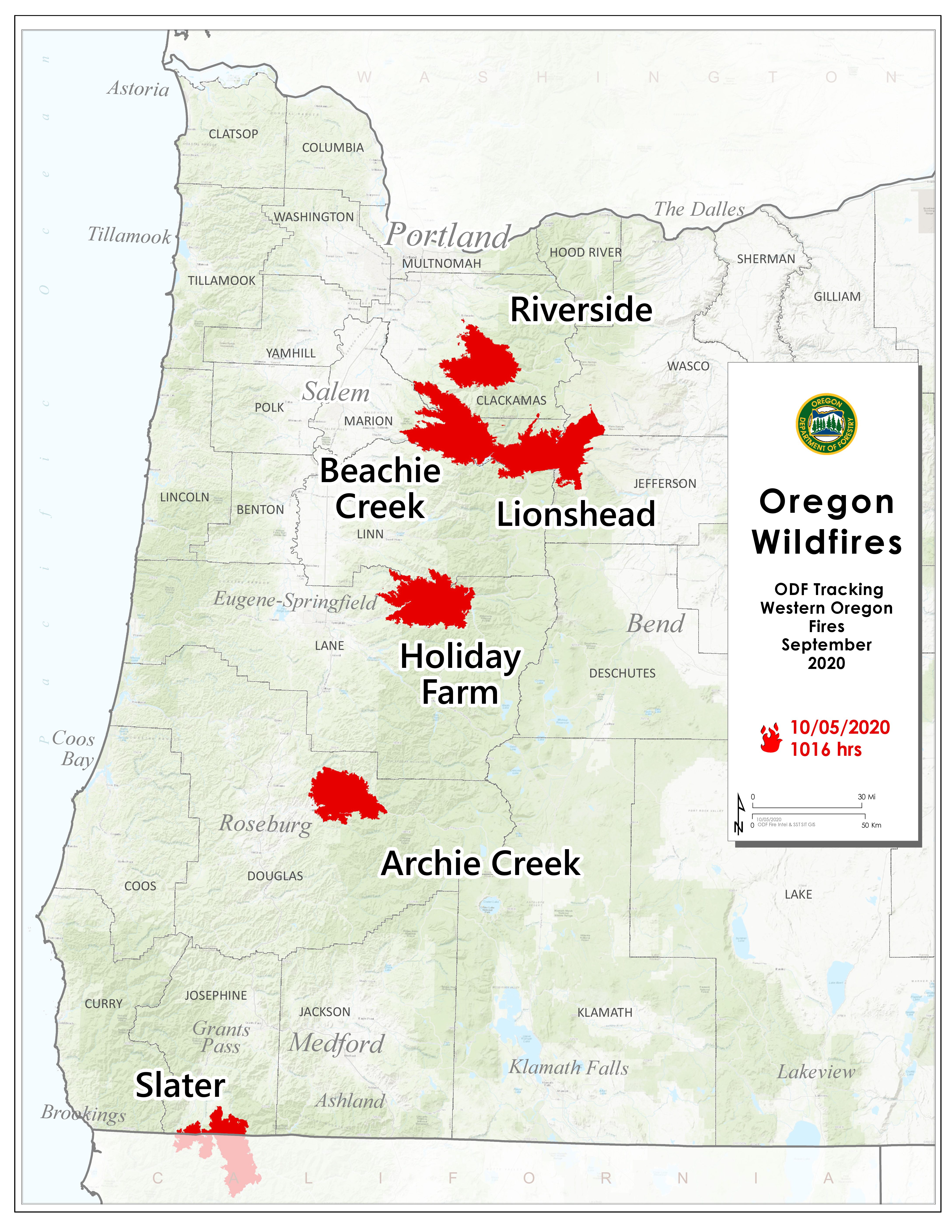
October 5, 2020
SALEM, Ore. – The Oregon Department of Forestry is closely tracking 6 major fires in Oregon, down from 17 originally (see table below for details). Fires are removed from the list when they are 100% lined and fire managers are confident in their progress toward containment.
Five of the six major fires still on the landscape have burned 100,000 acres or more in Oregon. One of those massive fires, Lionshead, is the sixth largest fire of the past 100 years in Oregon at 204,412 acres. Lionshead is the only one of these major fires that showed any growth in size Sunday – just 27 acres. Most posted double-digit gains in containment over the weekend. Yesterday also saw no new fires reported anywhere in the state.
Remember that fire season isn’t over yet, which means backyard burning and other restrictions are still in effect on ODF-protected lands. Check the public fire restrictions map to see current restrictions for your area.
| Fire name |
Acres burned |
Containment |
Location |
| Lionshead |
204,412 |
47.5% |
20 miles W of Warm Springs |
| Beachie Creek |
193,253 |
59% |
15 miles N of Detroit |
| Holiday Farm |
173,094 |
78% |
3 miles W of McKenzie Bridge |
| Riverside |
138,085 |
57% |
2 miles SE of Estacada |
| Archie Creek |
131,542 |
91% |
20 miles E of Glide |
| Slater |
44,597 in Oregon |
62% |
6 SE of Cave Junction (also in No. California) |
Closures
Santiam State Forest is still closed to the public. Before heading out to hunt or recreate on other state or federal public lands, please check to see if there are any restrictions or closures due to the recent fires. There are still portions of highways statewide that are closed. Use ODOT’s TripCheck to plan your route.
More information
October 2, 2020
SALEM, Ore. – ODF is closely tracking 6 major fires in Oregon, down from 17 originally (see table below for details). Fires are removed from the list when they are 100% lined and fire managers are confident in their progress toward containment.
Five of the six major fires still on the landscape have burned 100,000 acres or more in Oregon. One of those massive fires, Lionshead, is the sixth largest fire of the past 100 years in Oregon at 204,367 acres.
For fire season 2020, there have been 886 fires on ODF-protected lands that have burned 543,382 acres. Prior to 2020, the fire season of 1933—which included the first Tillamook Burn—was the worst on record for ODF-protected lands, with the loss of approximately 340,000 acres. Across all lands in Oregon, there have been 1,995 fires for 1,045,536 acres burned.
Remember that fire season isn’t over yet, which means backyard burning and other restrictions are still in effect on ODF-protected lands. Check the public fire restrictions map to see current restrictions for your area.
| Fire name |
Acres burned (est.) |
Containment |
Location |
| Lionshead |
204,355 |
37% |
20 miles W of Warm Springs |
| Beachie Creek |
192,848 |
59% |
15 miles N of Detroit |
| Holiday Farm |
173,094 |
70% |
3 miles W of McKenzie Bridge |
| Riverside |
138,070 |
45% |
2 miles SE of Estacada |
| Archie Creek |
131,542 |
79% |
20 miles E of Glide |
| Slater |
44,495 in Oregon |
50% |
6 SE of Cave Junction (also in No. California) |
Closures
Santiam State Forest is still closed to the public. Before heading out to hunt or recreate on other state or federal public lands, please check to see if there are any restrictions or closures due to the recent fires. There are still portions of highways statewide that are closed. Use ODOT’s TripCheck to plan your route.
More information
October 1, 2020
News Release from City of Salem
Posted on FlashAlert: October 1st, 2020 9:00 AM
Salem, Ore. – Marion County Fire Defense Board has extended the area ban on backyard burning and land clearing or slash burning, due to continued above-average temperatures.
However, recent rainfall has reduced dry conditions in our communities, so some restrictions are being relaxed.
What is allowed?
- BBQ or outside cooking fires in an approved device, fire ring or fireplace
- Warming fires in an approved fire ring or fireplace.
As a reminder, burning garbage is never allowed.
Please check with the Department of Agriculture and your local fire agency before agricultural burning.
Those living in rural areas are urged to maintain their defensible space by monitoring growth surrounding homes and structures, and to maintain adequate access for firefighting equipment entrance and escape.
Due to COVID-19, a request to voluntarily curtail outdoor burning is also in effect.
For More Information
For the most current burning information, in Salem, Keizer and Marion County Fire District #1, call 503-588-6524. For those in all other areas of Marion County, call 877-982-0011
The City of Salem will distribute any updates through local media, its website, and social media channels.
For more wildfire prevention information and restrictions, visit Keep Oregon Green at the Oregon Department of Forestry.
Background
On September 4, 2020, both the Marion and Polk County Fire Defense Boards issued a total burn ban for all areas of both counties. At the time, weather conditions were extremely hot and dry. Open burning and recreational fires posed a hazard to persons and property throughout the entire City of Salem area.
September 30, 2020
Sept. 30, 2020
For more information, contact Katherine Benenati, 503-871-0388 (Regional contacts included below)
SALEM — Crews continue to make progress clearing and repairing roads damaged by wildfire around the state, but there’s a lot of work to do before roads are fully reopened in parts of Oregon.
Roughly 47 miles of highway remain closed, down from a peak of 244, and roughly 43 miles are open to piloted traffic only.
In the last week, imminent threat trees were removed in 95 miles of damaged area. Imminent threat trees pose the greatest risk of falling.
While removing imminent threat trees has been a priority and must be done before some other repairs, crews are also assessing culverts, guardrail, pavement, slopes, signs and equipment for damage.
Here’s what drivers can expect around the state:
- OR 126E
- Current status: Pilot cars are running between MP 27.55 to MP 38 in one direction at a time. Check TripCheck.com for the latest schedule.
- So far we’ve removed imminent threat trees along 24 miles. We’ve assessed 19 bridges and 32 of 134 culverts. None of those were damaged. Of 494 signs we assessed, 424 will need to be replaced. All 45 miles of guardrails have been inspected and 1.35 miles will need to be replaced.
- Regional media contact: Angela Beers Seydel, 541-505-2069
- OR 22E
- Current status: Closed from MP 56 to MP 65. Pilot cars are guiding drivers between Gates and Detroit/Idanha. Residents should expect at least one hour to make a one-way trip. Check TripCheck.com for the schedule.
- So far we’ve removed almost all imminent threat trees along 17 miles. We’ve also assessed 1,022 signs, 104 of which will need to be replaced, 18.69 miles of guardrail, 3 miles of which are damaged, and 40 of 65 miles of pavement, none of which is damaged according to preliminary assessments.
- Regional media contact: Lou Torres, 503-559-7118
- OR 224
- Current status: Closed between MP 31 and MP 49.97. Forest Service Road 46 is closed as well.
- So far we’ve removed almost all imminent threat trees along 32 miles. We’ve also assessed 406 signs, 200 of which will need to be replaced. We’ve installed temporary signs for slides and ordered permanent signs.
- Regional media contact: Don Hamilton, 503-731-8265
- OR 138E
- Current status: Pilot cars are operating between MP 21 and 29. Expect delays.
- So far along a 24-mile stretch of damage, we’ve removed imminent threat trees along 22 miles. In that same area, 3 miles of pavement has been damaged. Of 7.55 miles of guardrail assessed, 5.5 miles has been damaged.
- Regional media contact: Dan Latham, 541-817-5200
A number of other east-west routes are open with no restrictions including: I-84, U.S. 26, U.S. 20 and OR 58.
You can track our progress online. ODOT’s wildfire resources webpage includes information on closures, repairs and assessments to date, links to photos, videos and more. You can also sign up for news and emergency alerts.
Even after roads are fully reopened, heavy rain will be a concern in fire-stricken areas. ODOT may have further work to do to stabilize hillsides or clear debris from falls. Slides and debris flows are a particular concern – especially after rains – in areas where fire has stripped away vegetation, tree roots and underbrush.
Know before you go
Partial openings that allow limited traffic while work continues will be common. Drivers can expect to see flaggers or pilot cars and should plan for frequent lane closures and limited access. Through traffic should still take alternate routes until local wildfire hazards are resolved.
Drivers should check TripCheck.com for updates on closures.
For pictures of road damage around the state: https://www.flickr.com/photos/oregondot/albums/72157715891016418
For videos of explaining the recovery challenges faced by ODOT crews: https://www.youtube.com/user/OregonDOT
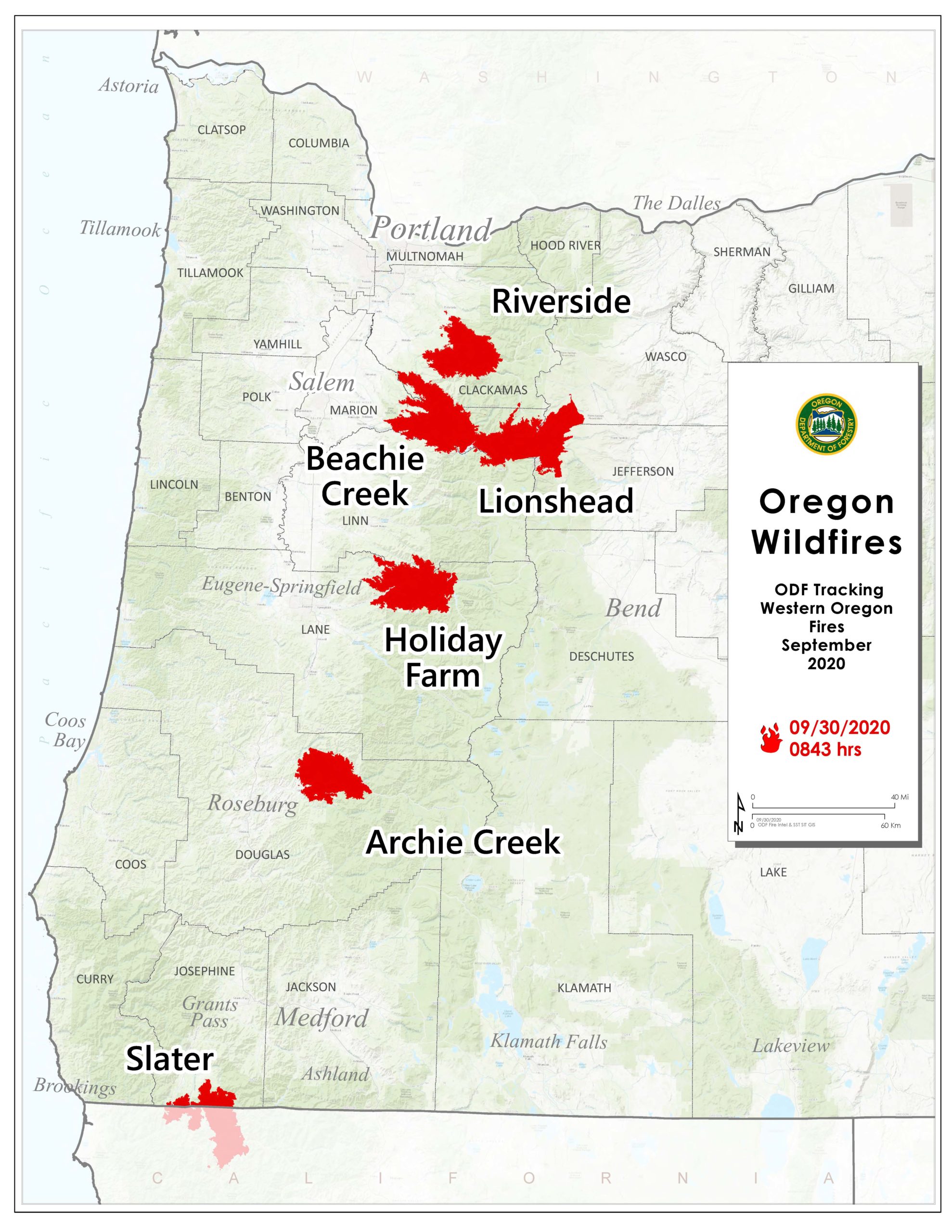
September 30, 2020
SALEM, Ore. – ODF is closely tracking 6 major fires in Oregon, down from 17 originally (see table below for details). Fires are removed from the list when they are 100% lined and fire managers are confident in their progress toward containment.
There have been more than 7,500 personnel from 39 states and multiple Canadian provinces assigned to fires in Oregon since Labor Day. This number doesn’t include many of the government employees, landowners, forestland operators, and members of the community who fought alongside and supported firefighting personnel over the past few weeks.
More than 1 million acres have burned in Oregon since the start of this year, which is nearly double the 10-year average of approximately 557,811.
| Fire name |
Acres burned |
Containment |
Location |
| Lionshead |
204,355 |
35% |
20 miles W of Warm Springs |
| Beachie Creek |
192,848 |
58% |
15 miles N of Detroit |
| Holiday Farm |
173,094 |
65% |
3 miles W of McKenzie Bridge |
| Riverside |
138,029 |
37% |
2 miles SE of Estacada |
| Archie Creek |
131,542 |
73% |
20 miles E of Glide |
| Slater |
44,286 in Oregon |
40% |
6 SE of Cave Junction (also in No. California) |
More information

Fire map for Sept. 30, 2020
September 29, 2020
News Release from Clackamas Co. Sheriff’s Office
Posted on FlashAlert: September 29th, 2020 10:01 AM
UPDATE (Tuesday, Sept. 29, 10 a.m.) — REDUCTION OF ALL EVACUATION LEVELS
Effective immediately (Tuesday, Sept. 29), the Clackamas County Sheriff’s Office — in collaboration with the Riverside Fire Incident Management Team (Pacific Northwest Team 3), Clackamas Fire District #1, Molalla Rural Fire Protection District #73, Colton Rural Fire Protection District #70, the Oregon Department of Forestry, the U.S. Forest Service, the Bureau of Land Management, and the Oregon Department of Transportation — is announcing a reduction of ALL evacuation levels.
All evacuation areas have been eliminated and returned to normal throughout Clackamas County, except in parts of the U.S. National Forest.
The U.S. National Forest is closed in the Clackamas River District, and there are partial closures to the Zig Zag Ranger District. Details here: https://www.fs.usda.gov/detail/mthood/news-events/?cid=FSEPRD811247
Please refer to the Wildfire Evacuation Zones map for details:
https://ccgismapservice.maps.arcgis.com/apps/webappviewer/index.html?id=fe0525732f1a4f679b75a5ccf1c84b30
Additional wildfire and resource information is available at https://www.clackamas.us/wildfires.
September 29, 2020
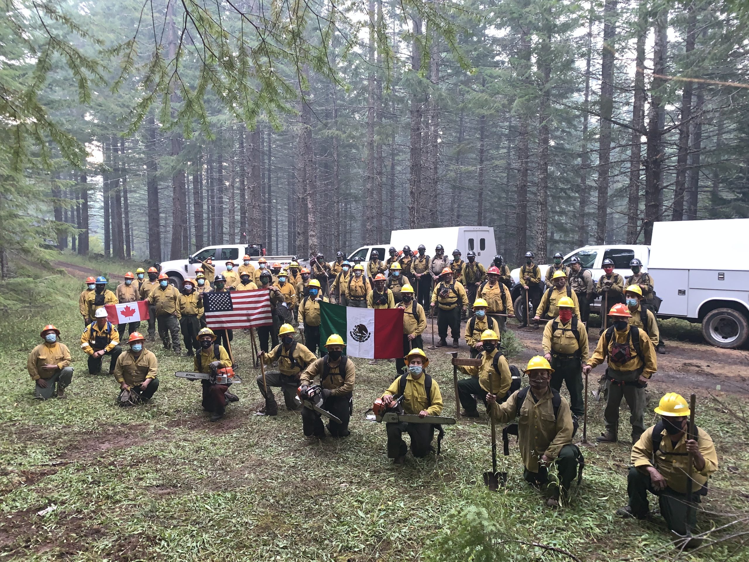
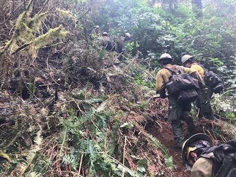
DOUGLAS COUNTY, Ore. – When wildfires struck the western U.S. late this summer, more than 500 Canadians heeded the call to help their southern neighbor under mutual assistance agreements. About half served on the Labor Day wildfires in Oregon, joining American fire personnel who came from 39 states. One of the wildfires that Canadians were assigned to was the Archie Creek Fire in Douglas County. The international nature of that firefighting effort was underscored by the presence of Canadians of Mexican origin working alongside U.S. firefighters.
Firefighter Jorge Camacho-Tornero from Alberta, Canada took the photo of firefighters from three nations at Archie Creek. He said the multi-national firefighters overcame “language barriers and differences in fire fighting strategies and tactics. Proof of this is the cohesion demonstrated by the fire crews.” Camacho-Tornero served as a paramedic and fire chief in Jalisco, Mexico. He went to Canada in 2008 as part of a wildland firefighter exchange program between Alberta and Jalisco and has since made Canada his home.
The photo he took Sept. 24 at the end of a shift shows 21 members of the Umpqua Type 2 initial attack crew that has been active in this region since the early 1970s and provided local knowledge to those new to the area. We also see Canadian firefighters and 40 members of the two Type 2 contracted American crews. According to their members, the largely Latinx crew members have been helping protect American forests since 1986 when the first crew of “lumbreros” (fire workers) was formed. They say they are proud to represent their original Mexican homeland and the Latinx community in their adopted country, the U.S.A.
The Archie Creek Fire was almost three-quarters contained as of Sept. 29. It is one of five “megafires” that exploded in the Labor Day wind event in Oregon, each burning over 100,000 acres.
September 28, 2020
SALEM, Ore. – Certain Oregon disaster survivors who have lost work as a direct result of the Oregon wildfires since Sept. 7 are eligible for Disaster Unemployment Assistance (DUA).
DUA benefits are available to workers in the eight Oregon counties that have been federally designated for disaster assistance: Clackamas, Douglas, Jackson, Klamath, Lane, Lincoln, Linn, and Marion.
DUA is funded by FEMA and administered by the Oregon Employment Department.
The purpose of DUA is to help workers whose primary incomes have been lost or interrupted by a federally declared disaster. It differs from regular state unemployment insurance because it also provides benefits to people who are self-employed, farmers, loggers and employees who work on commission. In addition, it helps those who are unable to reach their place of employment or are unable to work because of an injury as a direct result of the fires.
To receive DUA, an individual must not receive regular state unemployment, pandemic emergency unemployment compensation or pandemic unemployment assistance. Claimants must also meet normal eligibility requirements for an Oregon Unemployment Insurance claim.
The deadline to file a claim is Oct. 23, 2020. Required documentation, including proof of employment or self-employment at the time of the wildfires or income for 2019, must be submitted within 21 days of filing. To apply:
- Visit www.oregon.gov/EMPLOY/Disaster
- Call 503-570-5000 between the hours of 8 a.m. and 5 p.m.
- Packets are available at some evacuation sites and state WorkSource Centers.
Oregon DUA benefits apply to weeks of unemployment beginning with the week starting Sept. 13 and will be available through March 20, 2021, as long as the individual’s unemployment continues as a result of the wildfires.
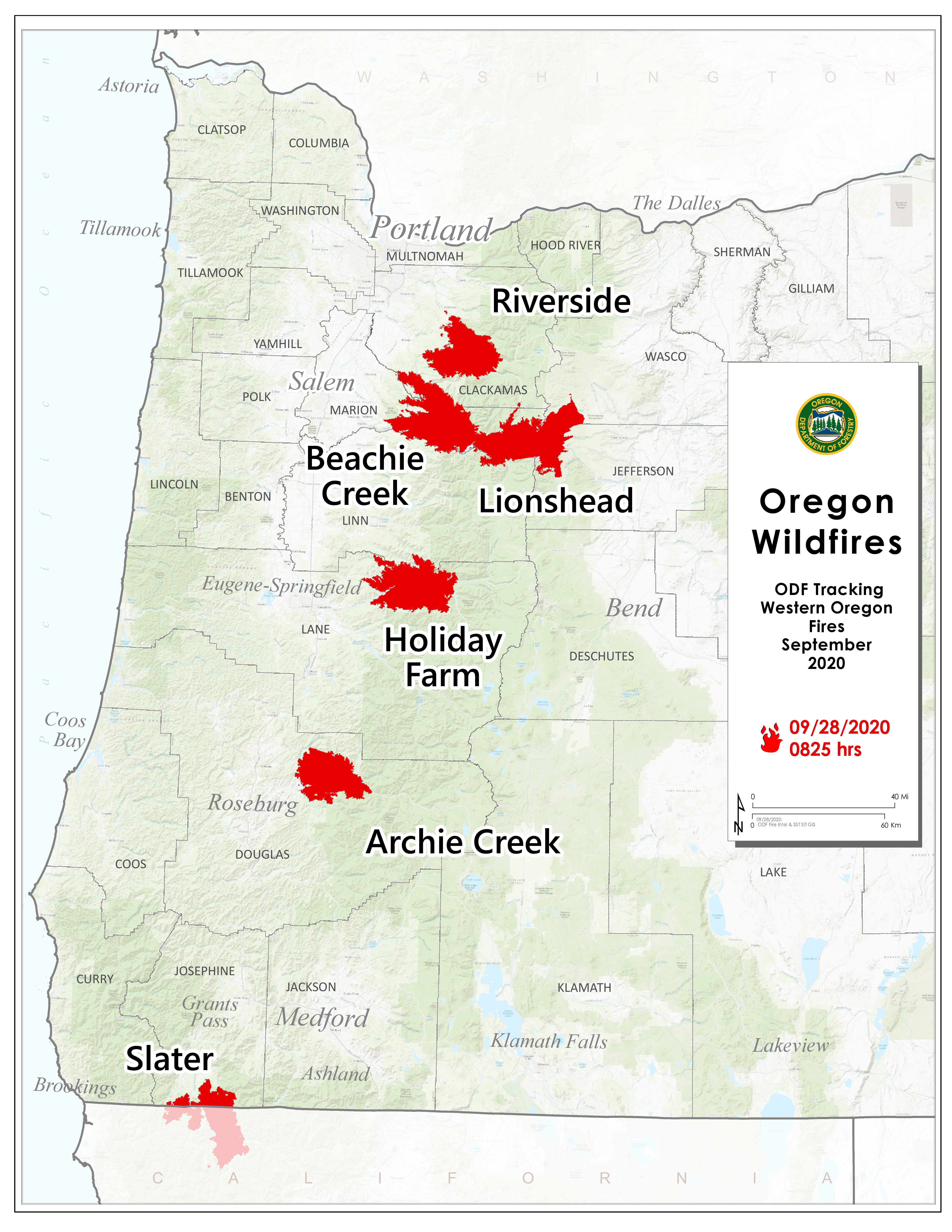
September 28, 2020
SALEM, Ore. – There were gains in containment over the weekend on all 6 major fires in Oregon that the Oregon Department of Forestry is tracking, down from 17 originally (see table below for details). Fires are removed from the list when they are 100% lined and fire managers are confident in their progress toward containment. On that basis, the Thielsen Fire, which has not grown from 9,971 acres in days and is more than two-thirds contained, has been removed.
There have been more than 7,500 personnel assigned to these fires, not including many of the government employees, landowners, forestland operators, and members of the community who are contributing every day. There have been resources from 39 states and multiple Canadian provinces in this fight alongside Oregonians.
About 1 million acres have burned in Oregon since the start of this year, which is nearly double the 10-year average of approximately 557,811.
| Fire name |
Acres burned (est.) |
Containment |
Location |
| Lionshead |
204,340 |
34% |
20 miles W of Warm Springs |
| Beachie Creek |
192,838 |
58% |
15 miles N of Detroit |
| Holiday Farm |
173,094 |
55% |
3 miles W of McKenzie Bridge |
| Riverside |
138,029 |
37% |
2 miles SE of Estacada |
| Archie Creek |
131,542 |
69% |
20 miles E of Glide |
| Slater |
44,239 in Oregon |
38% |
6 SE of Cave Junction (also in No. California) |
More information
September 27, 2020
News Release from Marion Co. Sheriff’s Office
Posted on FlashAlert: September 26th, 2020 3:00 PM
Downloadable file: Detroit, OR
As residents return to wildfire affected areas and start planning on re-building, contractors will be offering their services. It is important to make sure anyone you choose to work with is licensed with the Oregon Construction Contractors Board. Unfortunately, amongst the majority of reputable contractors, there are a number of scammers that target vulnerable people often affected by a disaster. There are a number of steps you can take to protect yourself from becoming victim to a scam. One of the ways you can protect yourself is by knowing the warning signs of a scam. These may include, but are not limited to:
- Offering to do the work at a very discounted rate
- Presenting a “limited time offer” due to leftover materials from a previous job
- Using pressure style tactics and going door to door
Please visit the Oregon Construction Contractors Board for more information: https://www.oregon.gov/ccb/Pages/Oregon-Wildfire-Resources-for-Home-and-Business-Owners.aspx
This webpage is specifically designed as a resource for home and business owners recovering from the wildfires. The most important thing you can do to protect yourself is verifying the license of any Oregon contractor at: https://www.ccb.state.or.us/search/.

September 25, 2020
SALEM, Ore. – The Oregon Department of Forestry is closely monitoring 7 major fires in Oregon, down from 17 originally (see table below for details). Fires are removed from the list when they are 100% lined and fire managers are confident in their progress toward containment. The South Obenchain and Brattain wildfires have both been dropped from this report.
There have been more than 7,500 personnel assigned to these fires, not including many of the government employees, landowners, forestland operators, and members of the community who are contributing every day. There have been resources from 39 states and multiple Canadian provinces in this fight alongside Oregonians.
About 1 million acres have burned in Oregon since the start of this year, which is nearly double the 10-year average of approximately 557,811.
| Fire name |
Acres burned (est.) |
Containment |
Location |
| Lionshead |
204,250 |
28% |
20 miles W of Warm Springs |
| Beachie Creek |
192,838 |
52% |
15 miles N of Detroit |
| Holiday Farm |
173,094 |
35% |
3 miles W of McKenzie Bridge |
| Riverside |
138,029 |
34% |
2 miles SE of Estacada |
| Archie Creek |
131,642 |
59% |
20 miles E of Glide |
| Slater |
44,205 in Oregon |
25% |
6 SE of Cave Junction (also in No. California) |
| Thielsen |
9,971 |
31% |
E of Diamond Lake |
More information
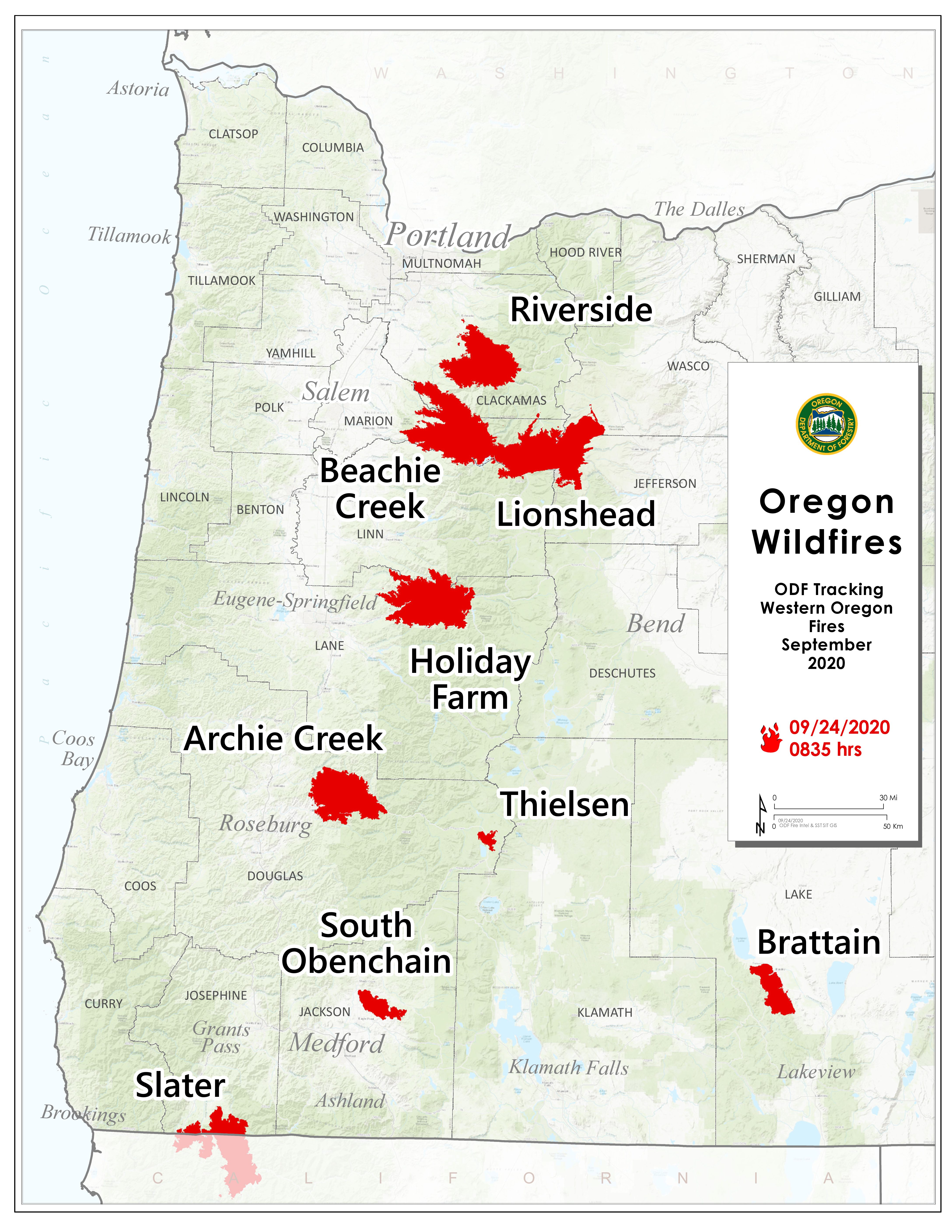
September 24, 2020
SALEM, Ore. – The Oregon Department of Forestry is closely monitoring 9 major fires in Oregon, down from 17 originally (see table below for details). Fires are removed from the list when they are 100% lined and fire managers are confident in their progress toward containment.
There have been more than 7,500 personnel assigned to these fires, not including many of the government employees, landowners, forestland operators, and members of the community who are contributing every day. There have been resources from 39 states and multiple Canadian provinces in this fight alongside Oregonians.
About 1 million acres have burned in Oregon since the start of this year, which is nearly double the 10-year average of approximately 557,811.
| Fire name |
Acres burned (est.) |
Containment |
Location |
| Lionshead |
203,566 |
15% |
20 miles W of Warm Springs |
| Beachie Creek |
192,838 |
49% |
15 miles N of Detroit |
| Holiday Farm |
173,094 |
35% |
3 miles W of McKenzie Bridge |
| Riverside |
138,029 |
34% |
2 miles SE of Estacada |
| Archie Creek |
131,598 |
55% |
20 miles E of Glide |
| Brattain |
50,951 |
90% |
8 miles S of Paisley |
| Slater |
43,833 in Oregon |
24% |
6 SE of Cave Junction (also in No. California) |
| S. Obenchain |
32,671 |
85% |
5 miles E of Eagle Point |
| Thielsen |
9,971 |
30% |
E of Diamond Lake |
More information
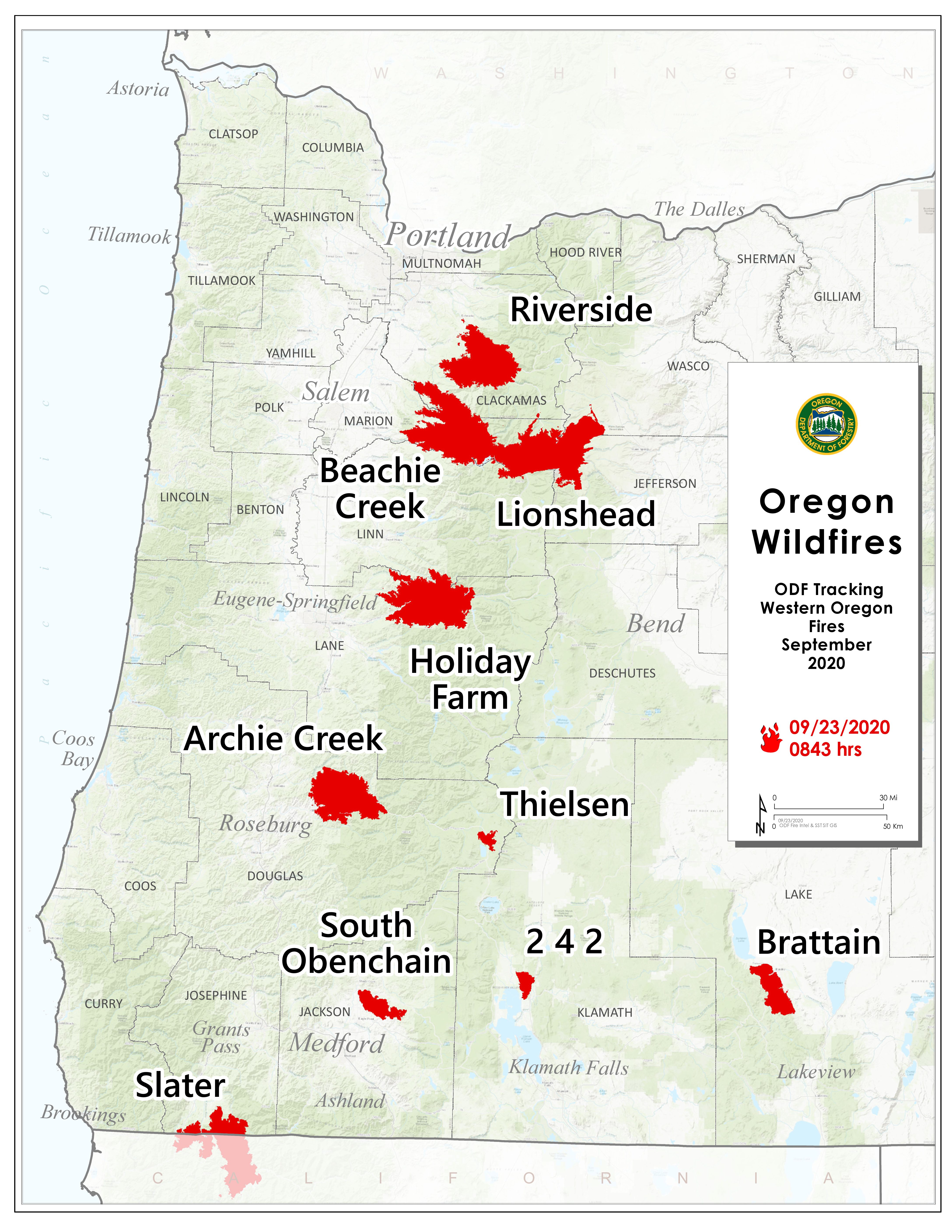
September 23, 2020
SALEM, Ore. – The Oregon Department of Forestry is closely monitoring 10 major fires in Oregon, down from 17 originally (see table below for details). Fires are removed from the list when they are 100% lined and fire managers are confident in their progress toward containment.
There have been more than 7,500 personnel assigned to these fires, not including many of the government employees, landowners, forestland operators, and members of the community who are contributing every day. There have been resources from 39 states and multiple Canadian provinces in this fight alongside Oregonians.
About 1 million acres have burned in Oregon since the start of this year, which is nearly double the 10-year average of approximately 557,811.
| Fire name |
Acres burned (est.) |
Containment |
Location |
| Lionshead |
203,685 |
15% |
20 miles W of Warm Springs |
| Beachie Creek |
192,828 |
46% |
15 miles N of Detroit |
| Holiday Farm |
173,094 |
27% |
3 miles W of McKenzie Bridge |
| Riverside |
138,027 |
31% |
2 miles SE of Estacada |
| Archie Creek |
131,598 |
52% |
20 miles E of Glide |
| Brattain |
50,751 |
87% |
8 miles S of Paisley |
| Slater |
42,215 in Oregon |
24% |
6 SE of Cave Junction (also in No. California) |
| S. Obenchain |
32,671 |
80% |
5 miles E of Eagle Point |
| Two Four Two |
14,473 |
95% |
N/NW of Chiloquin |
| Thielsen |
9,916 |
26% |
E of Diamond Lake |
More information

September 22, 2020
SALEM, Ore. – The Oregon Department of Forestry is closely monitoring 10 major fires in Oregon, down from 17 originally (see table below for details). Fires are removed from the list when they are 100% lined and fire managers are confident in their progress toward containment.
There have been more than 7,500 personnel assigned to these fires, not including many of the government employees, landowners, forestland operators, and members of the community who are contributing every day. There have been resources from 39 states and multiple Canadian provinces in this fight alongside Oregonians.
About 1 million acres have burned in Oregon since the start of this year, which is nearly double the 10-year average of approximately 557,811.
| Fire name |
Acres burned (est.) |
Containment |
Location |
| Lionshead |
198,916 |
13% |
20 miles W of Warm Springs |
| Beachie Creek |
192,775 |
38% |
15 miles N of Detroit |
| Holiday Farm |
173,094 |
22% |
3 miles W of McKenzie Bridge |
| Riverside |
138,020 |
26% |
2 miles SE of Estacada |
| Archie Creek |
131,598 |
44% |
20 miles E of Glide |
| Brattain |
50,510 |
55% |
8 miles S of Paisley |
| Slater |
42,215 in Oregon |
22% |
6 SE of Cave Junction (also in No. California) |
| S. Obenchain |
32,671 |
70% |
5 miles E of Eagle Point |
| Two Four Two |
14,473 |
89% |
W/NW of Chiloquin |
| Thielsen |
9,916 |
26% |
E of Diamond Lake |
More information

September 21, 2020
SALEM, Ore. – The Oregon Department of Forestry is closely monitoring 10 major fires in Oregon, down from 17 originally (see table below for details). Fires are removed from the list when they are 100% lined and fire managers are confident in their progress toward containment.
There have been more than 7,500 personnel assigned to these fires, not including many of the government employees, landowners, forestland operators, and members of the community who are contributing every day. There have been resources from 39 states and multiple Canadian provinces in this fight alongside Oregonians.
About 1 million acres have burned in Oregon since the start of this year, which is nearly double the 10-year average of approximately 557,811.
| Fire name |
Acres burned (est.) |
Containment |
Location |
| Lionshead |
198,647 |
13% |
20 miles W of Warm Springs |
| Beachie Creek |
192,764 |
38% |
15 miles N of Detroit |
| Holiday Farm |
170,637 |
17% |
3 miles W of McKenzie Bridge |
| Riverside |
137,880 |
25% |
2 miles SE of Estacada |
| Archie Creek |
131,598 |
41% |
20 miles E of Glide |
| Brattain |
50,447 |
52% |
8 miles S of Paisley |
| Slater |
42,214 in Oregon |
18% |
SE of Cave Junction (also in No. California) |
| S. Obenchain |
32,671 |
65% |
5 miles E of Eagle Point |
| Two Four Two |
14,473 |
77% |
W/NW of Chiloquin |
| Thielsen |
9,689 |
22% |
E of Diamond Lake |
September 20, 2020
We are closely monitoring 10 major fires in Oregon, down from 17 originally (see table below for details). Fires are removed from the list when they are 100% lined and fire managers are confident in their progress toward containment.
There are more than 7,500 personnel assigned to these fires, not including many of the government employees, landowners, forestland operators, and members of the community who are contributing every day. There have been resources from 39 states and multiple Canadian provinces in this fight alongside Oregonians.
About 1 million acres have burned in Oregon since the start of this year, which is nearly double the 10-year average of approximately 557,811.
You can also check out the weekend fire status update video from Chief of Fire Protection Doug Grafe.
| Fire name |
Acres burned (est.) |
Containment |
Location |
| Lionshead |
198,314 |
10% |
20 miles W of Warm Springs |
| Beachie Creek |
192,713 |
25% |
15 miles N of Detroit |
| Holiday Farm |
173,025 |
14% |
3 miles W of McKenzie Bridge |
| Riverside |
137,880 |
20% |
2 miles SE of Estacada |
| Archie Creek |
131,598 |
38% |
20 miles E of Glide |
| Brattain |
47,421 |
49% |
8 miles S of Paisley |
| Slater |
42,485 in Oregon |
18% |
SE of Cave Junction (also in No. California) |
| S. Obenchain |
32,671 |
55% |
5 miles E of Eagle Point |
| Two Four Two |
14,473 |
64% |
W/NW of Chiloquin |
| Thielsen |
9,703 |
22% |
E of Diamond Lake |
Please note: The acres burned estimates above are based very limited information available. These numbers will change over the next several days, in some cases significantly. We will be taking every opportunity to map these fires. Fire maps are an important tool for both ongoing response operations and keeping people informed.
More information
Inciweb (information on individual incidents)
September 19, 2020
We are closely monitoring 10 major fires in Oregon, down from 17 originally (see table below for details). Fires are removed from the list when they are 100% lined and fire managers are confident in their progress toward containment. There are more than 7,500 personnel assigned to these fires, not including many of the government employees, landowners, forestland operators, and members of the community who are contributing every day. There have been resources from 39 states and multiple Canadian provinces in this fight alongside Oregonians. About 1 million acres have burned in Oregon since the start of this year, which is nearly double the 10-year average of approximately 557,811.
| Fire name |
Acres burned (est.) |
Containment |
Location |
| Lionshead |
198,231 |
10% |
20 miles W of Warm Springs |
| Beachie Creek |
192,012 |
20% |
15 miles N of Detroit |
| Holiday Farm |
173,025 |
12% |
3 miles W of McKenzie Bridge |
| Riverside |
137,865 |
11% |
2 miles SE of Estacada |
| Archie Creek |
130,429 |
32% |
20 miles E of Glide |
| Brattain |
47,243 |
44% |
8 miles S of Paisley |
| Slater |
42,000 in Oregon |
10% |
SE of Cave Junction (also in No. California) |
| S. Obenchain |
32,833 |
45% |
5 miles E of Eagle Point |
| Two Four Two |
14,473 |
49% |
W/NW of Chiloquin |
| Thielsen |
9,536 |
18% |
E of Diamond Lake |
Please note: The acres burned estimates above are based very limited information available. These numbers will change over the next several days, in some cases significantly. We will be taking every opportunity to map these fires. Fire maps are an important tool for both ongoing response operations and keeping people informed.
More information
September 18, 2020
SALEM, Ore. – Oregon Department of Forestry is closely monitoring 10 major fires in Oregon, (see table below for details). Echo Mountain and the North Cascade complexes were removed from today’s report. Fires are removed from the list when they are 100% lined and fire managers are confident in their progress toward containment. There are more than 6,500 personnel assigned to these fires from across the nation and Canada. This doesn’t include the many government emergency response employees, landowners, forestland operators, and members of the community who are contributing to the fight in whatever way they can. About 1 million acres have burned in Oregon since the start of this year, which is nearly double the 10-year average of approximately 557,811.
| Fire name |
Acres burned (est.) |
Containment |
Location |
| Lionshead |
192,719 |
10% |
20 miles W of Warm Springs |
| Beachie Creek |
192,012 |
20% |
15 miles N of Detroit |
| Holiday Farm |
172,510 |
10% |
3 miles W of McKenzie Bridge |
| Riverside |
137,865 |
10% |
2 miles SE of Estacada |
| Archie Creek |
130,429 |
25% |
20 miles E of Glide |
| Brattain |
44,800 |
20% |
8 miles S of Paisley |
| Slater |
41,395 in Oregon |
10% |
SE of Cave Junction (also in No. California) |
| S. Obenchain |
32,833 |
35% |
5 miles E of Eagle Point |
| Two Four Two |
14,473 |
37% |
W/NW of Chiloquin |
| Thielsen |
9,995 |
15% |
E of Diamond Lake |
Please note: The acres burned estimates above are based very limited information available. These numbers will change over the next several days, in some cases significantly. We will be taking every opportunity to map these fires. Fire maps are an important tool for both ongoing response operations and keeping people informed.
More information
September 18, 2020
News release from Oregon Health Authority
Sept. 17, 2020, 5 p.m.
If you experienced uninsured losses or damage due to wildfires, you may qualify for disaster aid. Federal funds are available to help eligible individuals recover from wildfire in Clackamas, Douglas, Jackson, Klamath, Lane, Lincoln, Linn and Marion Counties.
Oregon received federal emergency aid to supplement state, tribal and local recovery efforts in areas wildfires and straight-line winds affected beginning on Sept. 7, 2020.
“Oregon is resilient, but to fight fires on this scale, we need all the help we can get,” said Governor Kate Brown. “I am grateful for the White House’s swift response in quickly granting a Presidential Disaster Declaration and the immediate implementation of the Federal Emergency Management Agency’s individual assistance program, which will help bring additional relief to Oregonians impacted by the devastation of these fires.”
Assistance may include grants for temporary housing and home repairs, low-cost loans to cover uninsured property losses and other programs to help individuals and business owners recover from the effects of the disaster.
Individuals and business owners who sustained losses in the designated areas can begin applying for assistance by registering online at www.DisasterAssistance.gov or by calling 1-800-621-3362 or 1-800-462-7585 TTY. You are encouraged to apply as soon as possible.
Federal assistance through FEMA’s Public Assistance program is available to Benton, Clackamas, Columbia, Coos, Deschutes, Douglas, Jackson, Jefferson, Josephine, Klamath, Lake, Lane, Lincoln, Linn, Marion, Multnomah, Tillamook, Wasco, Washington and Yamhill Counties.
Governor Brown provided an update on Oregon’s emergency response at a press briefing today.
You can find more information about applying for assistance, current conditions and other resources at wildfire.oregon.gov.
