June 11, 2021
Incident Commander: Jason Loomis, Northwest Team 7
ENTERPRISE, Ore. – This morning, at 6:00 a.m., NW Team 7 transitioned management of the fire back to local agencies. Northwest Team 7 would like to thank the entire Wallowa County community for their support as well as firefighters for all their hard work throughout this incident. Local agencies will continue to monitor conditions and will remain ready in the event there are changes to the current status.
An e-mail has been established specifically for inquiries about the fires. Please send questions to 2021.josephcanyon@firenet.gov
Joseph Canyon Fire – Start Date: June 4, 2021 Cause: Lightning Size: 7,610 acres Containment: 95%
Location: 23 miles southwest of Lewiston, ID.
Status: Weather patterns continued to provide favorable conditions for suppression actions due to cooler temperatures and scattered showers in the fire area yesterday. Minimal fire behavior occurred due to higher fine fuel moisture.
Dry Creek Fire – Start Date: June 3-4, 2021 Cause: Lightning Size: 1,585 acres Containment: 95%
Location: The Dry Creek Fire is located in a remote and rugged part of Hells Canyon, northeast of Joseph, OR.
Status: Weather patterns continued to provide favorable conditions yesterday for suppression efforts due to cooler temperatures and scattered showers in the fire area. Minimal fire behavior occurred due to higher fine fuel moisture and precipitation.
Weather: Cloudy skies are expected, with a slight chance for afternoon showers. South winds of 5-10 mph.
Evacuations: There are currently no evacuation orders associated with the Joseph Canyon and Dry Creek fires.
Closures: The Nez Perce Tribe has temporarily closed the Precious Lands Wildlife Management Area in Northeastern Oregon: https://inciweb.nwcg.gov/incident/article/7513/59633/
Fire Season Declared: Oregon Department of Forestry’s Northeast Oregon District proclaimed that they would go into fire season beginning Wednesday, June 9th at 12:01 a.m. They have new fire restriction signs located throughout the district, with a Fire Prevention information line; (541) 975-3027 and a QR code which will take you to www.bmidc.org, for current information on fire restrictions.
Prevention Message: Whether we are out in nature or home in our backyards, remember that it’s our role to protect the lands we love by preventing wildfires and recreating responsibly.
June 11, 2021
With conditions drier than normal for this time of year, the Oregon Department of Forestry’s Western Lane, South Cascade and West Oregon districts will enter fire season at 12:01 a.m. on Wednesday, June 16. This applies to ODF-protected lands in Benton, Linn, Lincoln, Polk, and Lane counties, the southern portion of Yamhill County and the northern portion of Douglas County. Separately, Linn, Benton and Lane counties traditionally impose a burn ban beginning June 16 each year. In all counties, the burning of backyard debris is prohibited during fire season.
“With our current fuel moistures, conditions are what we typically see in early to mid-July. All signs are pointing to a busy fire season as we progress further into the year,” said West Oregon District Forester Michael Curran. “The majority of our fire starts in the southern Willamette Valley are human caused, and we urge the public to be aware of Public Use Restrictions,” Curran said. The public can find information on use restrictions on ODF’s interactive map, social media, or by contacting their local ODF office.
Benton County Fire Defense Board Chief Rick Smith said, “We hope the public has an increased awareness of wildfires.” He recommends that landowners “Create defensible space around your property by removing dead vegetation, keeping grass and brush mowed short, and landscape plants green and well-watered. It can make the difference between losing and saving a structure in the event of a wildfire.”
For updates on fire danger levels, call the South Cascade Office (eastern Lane & Linn Counties) at 541-726-3588, ext. 1, the Western Lane Office (Includes northern Douglas County) at 541-935-2222, or the West Oregon Office (Benton, Polk, Lincoln & southern Yamhill Counties) at 541-929-6300.
June 10, 2021
SHADY COVE, Ore. – The first fire caused by a lightning strike from the thunderstorm that swept through the Rogue Valley on Wednesday is now 100% contained. The Sawyer Fire, located on Sawyer road northwest of Shady Cove, was lined and contained at 1/10th of an acre. It was spotted during a reconnaissance flight over areas that had taken lightning strikes just after 5 p.m. on Thursday.
Initially, there was thought to be two fires; however once on scene, firefighters determined there was only one. Four engines responded to the Sawyer fire and quickly established a line around it, mopping it up shortly after. As the fire was moving slowly and there weren’t any structures threatened, evacuations were never put in place.
While this is the first fire ignited from Wednesday’s storm, it likely won’t be the last; ODF Southwest Oregon District resources, including the Detection Center, will be continuing to monitor lightning-struck areas for potential holdover fires in the coming weeks. It’s very typical for fires to ignite in warmer weather in the days following thunderstorms. Residents in these areas are advised to report sightings of smoke by calling 911.
Fire updates are available online at www.swofire.com and Facebook, @ODFSouthwest.
June 10, 2021
KLAMATH FALLS, Ore. – Fire Danger is being raised to “High” this Friday morning for all federal, state, county and private lands in Klamath and Lake counties protected by the agencies of the South Central Oregon Fire Management Partnership, and some fire restrictions are going in place. The public is encouraged to be aware of the current regulations before working or recreating on wildlands in Klamath and Lake Counties.
The Fire Danger includes all private, county and state wildlands protected by the Oregon Department of Forestry (ODF) Klamath-Lake District. It also applies to the Fremont-Winema National Forest, the Bureau of Land Management (BLM) Lakeview District, and the Sheldon-Hart Mountain and Klamath Basin National Wildlife Refuge Complexes.
Early season summer-like hot, dry weather, depleted snowpack and rapid drying of forest fuels have resulted in fire danger levels reaching “High”. Fires starting in these conditions have potential for rapid fire spread and major damage.
Additionally, the ODF Klamath-Lake District will begin Public Regulated Use Closure starting at 12:01 a.m. Friday. Fire officials are putting these restrictions into effect to dramatically reduce the chance of an accidental fire start.
Under the Public Regulated Use Closure, the following activities are prohibited on all private, county and state wildlands:
- Smoking is prohibited while traveling, except in vehicles on improved roads.
- Open fires are prohibited, including campfires, charcoal fires, cooking fires and warming fires, except at designated locations. Portable cooking stoves using liquefied or bottled fuels are allowed.
- Chainsaw use is prohibited between the hours of 1:00 p.m. and 8:00 p.m. Chainsaw use is allowed at all other hours if the following firefighting equipment is present with each operating saw: one axe, one shovel and one 8 ounce or larger fire extinguisher. A fire watch also is required at least one hour following the use of each saw.
- Use of motor vehicles, including motorcycles and all-terrain vehicles, is prohibited, except on improved roads and except for vehicle use by a landowner and employees of the landowner conducting activities associated with their livelihood. Landowners and their employees conducting activities associated with their livelihood shall carry a shovel and 2 ½ pound fire extinguisher when operating ATVs off improved roads.
- Possession of the following firefighting equipment is required while traveling in a motorized vehicle, except on state highways, county roads and driveways: one shovel and one gallon of water or one 2 ½ pound or larger fire extinguisher, except for all-terrain vehicles and motorcycles, which must be equipped with an approved spark arrestor in good working condition.
- Use of all fireworks is prohibited.
- Cutting, grinding, and welding of metal is prohibited. For landowners and employees of the landowner on their own land while conducting activities associated with their livelihood, cutting, grinding, and welding of metal is prohibited between the hours of 1:00 p.m. and 8:00 p.m. At all other times, the area is to be cleared of flammable vegetation, and the following firefighting equipment is required: one axe, one shovel and one 2 ½ pound or larger fire extinguisher in good working order.
Also, the May 15 “Fire Season in Effect” declaration restricted debris burning and timber harvest operations.
In Klamath County, wildland and structural fire protection agencies have agreed to prohibit all outdoor debris burning through the fire season.
Forest operations that require a permit to operate power-driven machinery are required to have fire tools, on-site water supply and watchman service on privately owned forest land.
The release of sky lanterns is prohibited during any time of the year. The discharge of exploding targets and the discharge of tracer ammunition is not permitted during the duration of the fire season.
For more information on restrictions please visit: https://www.oregon.gov/odf/fire/pages/restrictions.aspx
The Industrial Fire Precaution Level (IFPL) is being raised to a Level II on federal lands. Under IFPL II, the following may operate only between the hours of 8 p.m. and 1 p.m.:
- Power saws expect at loading sites
- Cable yarding
- Blasting
- Welding or cutting of metals
Personal and commercial woodcutters are reminded of their responsibility to stay informed of current IFPLs and all restrictions that apply to activities conducted on public lands. Failure to comply with precautionary fire requirements may result in the issuance of a Violation Notice.
For more information on IFPL restrictions please visit: www.scofmp.org.
On the BLM Lakeview District, Public Use Restrictions in the Klamath River Canyon remain in place. They went into effect May 15 for BLM managed lands withing a half mile of the Klamath River from the Keno Dam downstream to the Oregon/California border. The full order can be found at www.scofmp.org/files/BLM-PUR.pdf.
This year has seen an early start to wildfire season in South Central Oregon and conditions continue to dry out as summer approaches. The public is asked to use extreme caution with anything that can potentially spark a wildfire. Equipment should be checked to ensure spark arresters are in working order.
Anyone going out into wildlands should be prepared with water, a shovel, fire extinguisher and axe. Campfires should never be left unattended and should be dead out and cold to the touch before leaving. If you suspect a wildfire, please report it to 911.
June 10, 2021
Incident Commander: Jason Loomis, Northwest Team 7
Enterprise, Oregon – Demobilization of resources continues today as conditions have moderated and suppression actions have been successful. NW Team 7 is preparing for demobilization and to transition the fires to local agencies that are fully prepared to manage these fires in their current condition. The Incident Management Team remains available in the event the situation changes.
A new e-mail has been established for information inquiries on the fire. Please send questions to 2021.josephcanyon@firenet.gov
Joseph Canyon Fire – Start Date: June 3-4, 2021 Cause: Lightning Size: 7,610 acres Containment: 90%
Location: 23 miles southwest of Lewiston, ID.
Status: Monitoring of the Joseph Canyon fire continued yesterday with the only observed smoke from interior hotspots on the southwest flank of the fire. Crews continued to monitor and patrol lines.
Dry Creek Fire – Start Date: June 3-4, 2021 Cause: Lightning Size: 1,564 acres Containment: 90%
Location: The Dry Creek Fire is located in a remote and rugged part of Hells Canyon, northeast of Joseph, OR.
Status: The Dry Creek Fire is in very good shape. Two drone flights were completed yesterday looking for smoke and hot spots. The full perimeter was flown with only two smokes within the interior of the fire area observed.
Weather: Light steady rain is expected through the day, moderating towards the afternoon.
Evacuations: There are currently no evacuation orders associated with the Joseph Canyon and Dry Creek fires.
Closures: The Nez Perce Tribe has temporarily closed the Precious Lands Wildlife Management Area in Northeastern Oregon: https://inciweb.nwcg.gov/incident/article/7513/59633/
Fire Season Declared: Oregon Department of Forestry’s Northeast Oregon District proclaimed that they would go into fire season beginning Wednesday, June 9th at 12:01 a.m. They have new fire restriction signs located throughout the district, with a Fire Prevention information line; (541) 975-3027 and a QR code which will take you to www.bmidc.org, for current information on fire restrictions.
Prevention Message: Breathe easy, prevent wildfires.
June 9, 2021
Incident Commander: Jason Loomis, Northwest Team 7
Enterprise, Oregon – The objective for both the Joseph Canyon and Dry Creek fires is to limit the duration and size while accounting for firefighter safety. Securing and mopping up continues on the fires with fire crews and equipment being released to adjust the fire organization for the current fire situation.
NW Team 7 is anticipating a long and busy fire season. The emphasis is to not only minimize fire size and duration but also manage early season fatigue for all crew and management team members. Demobilization of resources continues today as conditions have moderated and suppression actions have been successful.
Joseph Canyon Fire – Start Date: June 3-4, 2021 Cause: Lightning Size: 7,610 acres Containment: 60%
Location: 23 miles southwest of Lewiston, ID.
Status: The Joseph Canyon fire received 5 hours of precipitation yesterday, significantly dampening any remaining hot spots. Firefighting resources will continue to demobilize today in line with changing weather conditions.
Dry Creek Fire – Start Date: June 3-4, 2021 Cause: Lightning Size: 1,564 acres Containment: 60%
Location: The Dry Creek Fire is located in a remote and rugged part of Hells Canyon, northeast of Joseph, OR.
Status: Crews continue to mop up any observed hot spots. Ongoing monitoring of areas less accessible to firefighting resources continues.
Weather: Today will start out mostly cloudy with cooler than normal temperatures. A high chance of rain is likely Wednesday. Isolated thunderstorms are possible. Winds will be north-northwest 5-10 mph.
Evacuations: There are currently no evacuation orders associated with the Joseph Canyon and Dry Creek fires.
Closures: The Nez Perce Tribe has temporarily closed the Precious Lands Wildlife Management Area in Northeastern Oregon: https://inciweb.nwcg.gov/incident/article/7513/59633/
Fire Season Declared: Oregon Department of Forestry’s Northeast Oregon District proclaimed that they would go into fire season beginning Wednesday, June 9th at 12:01 a.m. They have new fire restriction signs located throughout the district, with a Fire Prevention information line; (541) 975-3027 and a QR code which will take you to www.bmidc.org, for current information on fire restrictions.
Prevention Message: Protect your property, friends, and family – prevent wildfires.
June 8, 2021
GALICE, Ore. – On Tuesday, June 8, at approximately 10:45 a.m., Oregon Department of Forestry Southwest Oregon District resources responded to a structure fire at the Galice Resort alongside Rural Metro Fire. The fire originated in the building, but quickly spread to the wildland, igniting five small fires around the property.
Five ODF engines, a Type 2 helicopter and an air attack plane were all dispatched immediately. Engines and firefighters on the ground worked quickly to line and mop up the fires; accumulatively, 1/10 of an acre burned. Windy conditions contributed to the fire spreading beyond the structure, causing concern for nearby houses directly across the street; however, all fires were extinguished well before reaching those areas. As a precaution, residents self-evacuated. ODF resources will remain on scene to ensure any additional hotspots are found and extinguished. Meanwhile, the type 2 helicopter performed more than 20 bucket drops on the building itself, helping structural engines to extinguish the flames.
Rural Metro firefighters will be investigating the cause of the fire. ODF is thankful to our partner agencies, including Rural Metro Fire, County Fire Department, Grants Pass Fire Rescue, Rogue River Fire Department #1, Josephine County Sheriff’s Office, Oregon State Police and Josephine County Roads Department. Our strong partnerships allow us to tackle these complex incidents quickly, safely and effectively.
Fire updates are always available online at www.swofire.com and Facebook, @ODFSouthwest.
June 8, 2021
Incident Commander: Jason Loomis, Northwest Team 7
Northwest Incident Management Team 7 began full management of the Joseph Canyon and Dry Creek fires this morning at 6:00 a.m. The fires were started from an overnight lightning storm the night of June 3, 2021. The fires are burning in steep, rugged and inaccessible terrain in northern Wallowa County. The objective for both fires is to limit the duration and size while accounting for firefighter safety. Values at risk include human safety, private property, cultural and natural resources. Fires are burning on lands managed by the Wallowa-Whitman National Forest, Bureau of Land Management and Oregon Department of Forestry and Washington Department of Natural Resources.
Joseph Canyon Fire – Start Date: June 3-4, 2021 Cause: Lightning Size: 7,575 acres Containment: 20%
Location: 23 miles southwest of Lewiston, ID.
Status: Two hotshot crews continued to work along the eastern flank of the fire. The western edge of the fire was moving towards monitoring status. The eastern and northwestern flanks of the fire are contained. The southern edge of the fire continues to be a challenge due to the rugged terrain.
Dry Creek Fire – Start Date: June 3-4, 2021 Cause: Lightning Size: 1,500 acres Containment: 50%
Location: The Dry Creek Fire is located in a remote and rugged part of Hells Canyon, northeast of Joseph, OR.
Status: Some interior burning occurred yesterday towards the northwest flank. The burning was confined to the fire’s interior and not a threat to containment lines. Firefighters continued to mop up perimeter, strengthening lines with continued monitoring of the northeast flank of the fire. Three hotshot crews are currently assigned to the fire with the addition of two Wildland Fire Modules. Wildland Fire Modules are highly skilled and versatile fire crews that provide technical and ecological based expertise in the areas of long-term planning, ignitions, holding, and fire suppression.
Weather/Fire Behavior: Today will start out partly cloudy with cooler than normal temperatures. There is a chance of rain Wednesday and Thursday. Winds will be Northwest 5-10 mph with fire continuing to burn in short grass and light fuels. There is potential for half mile an hour rate of spread expected on steep slopes with wind. A significant warm up is anticipated through the weekend.
NW Team 7 is anticipating a long and busy fire season, the emphasis is to not only minimize fire size and duration but also manage early season fatigue for all crew and management team members. Demobilization of resources will begin as early as today as conditions have moderated and suppression actions have been successful.
Evacuations: There are currently no evacuation orders associated with the Joseph Canyon and Dry Creek fires.
Closures: The Nez Pierce Tribe has temporarily closed the Precious Lands Wildlife Management Area in Northeastern Oregon: https://inciweb.nwcg.gov/incident/article/7513/59633/
Prevention Message: Now more than ever, please prevent wildfires.
Fire Season Declared: Oregon Department of Forestry; Northeast Oregon District proclaimed that they would go into fire season beginning Wednesday, June 9th at 12:01 a.m. They have new fire restriction signs located throughout the district, with a Fire Prevention information line; (541) 975-3027 and a QR code which will take you to www.bmidc.org, for current information on fire restrictions.
June 7, 2021
LA GRANDE, Ore. – A drier than normal spring and stretches of warmer than normal weather has prompted Oregon Department of Forestry (ODF) to begin fire season on private forest lands in northeast Oregon. Fire season will begin at 12:01 a.m., Wednesday, June 9 for about 2 million acres of forest and range lands protected by ODF Northeast Oregon District.
“We’ve been seeing fire conditions and behavior that is more indicative of mid to late July recently,” said Joe Hessel, ODF District Forester.
Hessel said, “The fuel moisture of our dead fuels is already at a point where they will readily burn, and it won’t be long before our grasses have cured. By declaring fire season, we can put measures in place to prevent human-caused fires. We’re already seeing fires caused by lightning, so we need to use the tools we have to minimize other ignition sources.”
The fire season declaration places fire prevention restrictions on landowners and public. Additionally, fire prevention regulations on industrial logging and forest management activities are put into place. Lands affected include private, state, county, municipal, and tribal lands in Union, Baker, Wallowa, and Umatilla counties along with small portions of Malheur, Morrow and Grant counties within the Northeast Oregon Forest Protection District.
Hessel states, “In a normal season, we would have experienced spring moisture which typically delays the start of fire season until later in June. This season, significant amounts of moisture have been absent. We’ve already had substantial fires on the landscape and it’s time to do everything we can to mitigate fire starts.”
Thunderstorms that passed through the area last week caused several early season ignitions around the region.
During fire season:
• Debris burning is prohibited. Burn Permits will not be issued for burn barrels or open burning on any private forest and range lands within the Northeast Forest Protection District of the Oregon Department of Forestry (ODF).
• The use of exploding targets, tracer ammunition or any bullet with a pyrotechnic charge in its base is prohibited.
• Logging and other industrial operations must meet requirements for fire prevention, such as fire tools, water supply, and watchman service when those operations are occurring on lands protected by ODF. Contact your local Stewardship Forester at any ODF office for more information.
• Campfires must be DEAD OUT! Recreationists are reminded that campfires need to be attended and fully extinguished before being left. Get permission from the landowner prior to starting a campfire.
• The use of sky lanterns is illegal at all times in Oregon.
Note: we have new fire restriction signs located throughout the district, with a Fire Prevention information line; (541) 975-3027 and a QR code which will take you to www.bmidc.org, for current information on fire restrictions.
To report a fire, dial 9-1-1.
For information on the weekends call:
Blue Mountain Interagency Dispatch Center La Grande (541) 963-7171
Make sure you know what the fire restrictions are before you head out. Check with your local Forest Service office for fire regulations on National Forest land, or BLM office for lands managed by the Bureau of Land Management. Information on Public-Use Restrictions on the Oregon Department of Forestry, Umatilla National Forest and Wallowa Whitman National Forest can be found at http://bmidc.org/index.shtml under Current Information: Fire Restrictions.
June 6, 2021
JOSEPH, Ore. – Extreme winds Saturday challenged air resources battling the Joseph Canyon Fire, but also aided the suppression effort by pushing the active fire line back onto itself in some areas.
By the end of the day, the fire footprint was estimated to be 3,700 acres. The fire is burning in northern Wallowa County and southeast Washington about 23 miles southwest of Lewiston, ID.
“This is probably one of the most difficult places to fight fire in Oregon,” said Matt Howard, Deputy Agency Administrator for Oregon Department of Forestry. “Joseph Canyon is known for its extreme terrain, communications challenges, and natural hazards.”
Northwest 7 Type 2 Incident Management Team is shadowing the interagency Blue Mountain Type 3 Incident Management Team today and will assume command of the fire Monday.
Engine crews were able to establish and hold a line along 10 miles of roadway bordering the east side of Cottonwood Creek. They will continue working today to reinforce the line and contain any slop overs (areas where the fire has crossed the line).
Cooler temperatures and higher humidity today should slow the fire’s progression. Winds are expected to taper off by midday, allowing aviation resources to work aggressively to hold the fire between Cottonwood Creek and Rye Ridge.
Four hand crews, two engines and three helicopters are currently assigned to the fire. Additional aviation and ground resources are arriving steadily.
Fire personnel from Oregon Department of Forestry, Wallowa‐Whitman National Forest, Vale Bureau of Land Management and Washington Department of Natural Resources are working cooperatively to protect public and private lands affected by the fire.
Several ranchers and permittees were moving cattle out of the fire zone to protect the livestock and allow firefighters unrestricted access into and around the fire footprint.
“The private landowners involved are no stranger to fire,” Howard said. “We have good communication with them and, given the circumstances, they are happy with the progress that has been made in battling this wildfire.”
June 5, 2021
JOSEPH, Ore. – Lightning activity from thunderstorms passing through the area Thursday night and Friday morning ignited multiple wildfires in the northeast corner of the state. Responding resources have successfully contained some of the ignitions, however others remain active and uncontained.
The Joseph Canyon Fire, initially reported Friday morning by Washington Department of Natural Resources (DNR), is burning in steep rugged terrain in the Joseph Canyon area of northern Wallowa County, Oregon. Low humidity, warm temperatures, and breezy winds hampered firefighting efforts Friday and the fire rapidly spread through the grassy vegetation within the canyon and crossed over the state line into Washington. The fire continued to burn actively overnight in the flashy fuels and is estimated to be approximately 2,000 acres.
The fire is burning on lands protected by the Oregon Department of Forestry and Bureau of Land Management. A local interagency Type 3 team will shadow firefighters today and transition management of the fire to the team at 6 p.m. tonight.
A second fire, Dry Creek, is burning just to the east of the Joseph Canyon Fire. It is estimated to be 328 acres and is located solely on Wallowa-Whitman National Forest land.
All jurisdictions involved share common objectives in managing these fires, which is to fight the fires aggressively while maximizing the safety of the public and all fire staff involved. Due to the remote location and steep rugged terrain, the fires are mostly being fought by air attack. Rappelers, smoke jumpers and air tankers were brought in for initial suppression efforts. Three large airtankers dropped retardant along the perimeter of the Joseph Canyon Fire Friday to slow the fire growth. In addition to firefighter delivery, three Type 2 helicopters were used to drop water on hot spots. These aerial resources will continue to support firefighters on the ground today, as well as the addition of Single Engine Air Tankers. Active fire behavior is expected today with low humidity and increasing winds as a cold front passes through.
CONTACTS: Sara Bethscheider (541-426-5585), Christie Shaw (541-263-0661)
June 3, 2021
WHITE CITY, Ore. – The East Antelope Fire, located along the 9600-block of E. Antelope Road outside of White City, is now 98% contained following continuous mop-up efforts by fire crews. Hot weather has increased holdover hot spots in the area, slowing up the mop-up process; the fire remains at 49 acres, affecting private and Bureau of Land Management (BLM) lands. Resources will remain on scene until all hot spots are found and extinguished.
The E. Antelope Fire was initially reported around 2:45 p.m. on Saturday, May 29. Oregon Department of Forestry Southwest Oregon District would like to thank its partner agencies that responded to the fire, including Jackson County Fire District 3, Lake Creek Fire, BLM and U.S. Forest Service Rogue River-Siskiyou National Forest resources, Jackson County Sheriff’s Office, Jackson County Emergency Management and Jackson County Roads Department.
The cause of the fire remains under investigation. This will be the final update on this incident unless conditions significantly change.
Fire updates are always available online at www.swofire.com and Facebook, @ODFSouthwest.
June 2, 2021
The change in restrictions will affect ODF Southwest Oregon District protected lands only.
JACKSON & JOSEPHINE COUNTIES, Ore. (June 2, 2021) – The fire danger level on Oregon Department of Forestry Southwest Oregon District-protected lands in Jackson and Josephine counties will increase to “moderate” (blue) on Friday, June 4, 2021 at 12:01 a.m. Please be aware that this level change means that additional fire restrictions for the public will be in effect. The Industrial Fire Precaution Level will remain at Level I (one).
These regulations impact 1.8 million acres of state, private, county, city and Bureau of Land Management lands protected by ODF’s Southwest Oregon District.
Public fire restrictions currently in effect, which will remain in effect, include:
- No debris burning, including piles and debris burned in burn barrels.
- No fireworks on or within 1/8 of a mile of forestland.
- Exploding targets and tracer ammunition, or any bullet with a pyrotechnic charge in its base, are prohibited.
- Smoking while traveling will only be allowed in enclosed vehicles on improved roads, in boats on the water and other specifically designated locations.
- Any electric fence controllers must be approved by a nationally recognized testing laboratory, such as Underwriters Laboratories Inc., or be certified by the Department of Consumer and Business Services, and be installed and used in compliance with the fence controller’s instructions for fire safe operation.
Beginning Friday at 12:01 a.m., the following public fire restrictions will take effect:
- Open fires are prohibited, which includes campfires, charcoal fires, cooking fires and warming fires, except at locations deemed a designated campground. Portable cooking stoves using liquefied or bottled fuels are still allowed;
- Chainsaws may not be used between 1:00 p.m. and 8:00 p.m. during moderate fire danger. During hours outside of this time frame, chain saws may be used but require that the operator have one shovel and one 8-oz or larger fire extinguisher at the work site. A fire watch is also required for one hour after each chainsaw use;
- Cutting, grinding and welding of metal is not allowed between 1:00 p.m. and 8:00 p.m. during moderate fire danger. These activities will be allowed during hours outside of this time frame only if the work site is cleared of potentially flammable vegetation and other materials, and a water supply is at the job site;
- The mowing of dead or dried grass with power-driven equipment is not allowed between 1:00 p.m. and 8:00 p.m. during moderate fire danger. This restriction does not include mowing of green lawns, or equipment used for the commercial culture and harvest of agricultural crops;
- Motorized vehicles, including motorcycles and all-terrain vehicles, will be allowed only on improved roads free of flammable vegetation. One shovel and one gallon of water, or one 2.5 pound or larger fire extinguisher, is required while traveling.
- Possession of the following firefighting equipment is required while traveling, except on state highways, county roads and driveways: one shovel and one gallon of water or one 2½ pound or larger fire extinguisher. As noted above, all-terrain vehicles and motorcycles must be equipped with one 2½ pound or larger fire extinguisher.
- Any other spark-emitting internal combustion engine use not specifically mentioned is not allowed between 1:00 p.m. and 8:00 p.m. during moderate fire danger. Use of any spark-emitting internal combustion engine is allowed outside of this time frame only if the work site is cleared of potentially flammable vegetation and other materials, and a water supply is at the job site;
For more information about the Oregon Department of Forestry Southwest Oregon District’s fire season public restrictions, please call or visit the Southwest Oregon District unit office nearest to you:
- Medford Unit, 5286 Table Rock Rd., Central Point, (541) 664-3328
- Grants Pass Unit, 5375 Monument Dr., Grants Pass, (541) 474-3152
Fire season information is also available online at our Facebook page: @ODFSouthwest and our website: www.swofire.com.
May 31, 2021
WHITE CITY, Ore. – The East Antelope Fire, located on the 9600-block of East Antelope Road outside of White City, remains 100% lined and is now 90% mopped up. Firefighters were able to make this tremendous amount of progress during Sunday’s day shift and through the night; operations today will focus on reaching near, if not compete containment. It remains 49 acres in size, and is on private and BLM land.
An infrared drone flight was conducted Sunday evening, revealing multiple hotspots within the fire perimeter. Overnight, fire crews worked to extinguish those areas. Additional gridding will take place today, allowing firefighters to canvas the entire footprint of the fire for potential areas of concern. This evening, crews will remain on scene and do an additional infrared scan. This technology is extremely important to finalizing operations, as it detects heat in specific areas, even when indicators like smoke or embers aren’t immediately visible.
The E. Antelope Fire was initially reported on Saturday around 2:45 p.m. The road was closed to traffic with the exception of fire resources and residents; these closures have since been lifted. The Jackson County Sheriff’s Office and Jackson County Emergency Management issued level two (Be Set) evacuations orders for the immediate area; they have since been downgraded to level 1 (Be Ready). Additional evacuation information is available through the Jackson County Sheriff’s Office and Jackson County Emergency Management.
ODF Southwest Oregon District would like to thank our partner agencies who have helped on the fire lines, including the Bureau of Land Management, the U.S. Forest Service Rogue River-Siskiyou National Forest, Jackson County Fire District 3 and Lake Creek Fire. We would also like to thank the veterans who have spent their Memorial Day weekend with us, once again protecting our community; your efforts on the fire and in your military service are much appreciated.
The cause of this fire remains under investigation. Additional information relating to the cause will be released when it is safe to do so without hampering the investigation.
Fire information for Jackson and Josephine counties is always available on online at www.swofire.com and Facebook, @ODFSouthwest.
May 29, 2021
WHITE CITY, Ore. – Oregon Department of Forestry (ODF) Southwest Oregon District firefighters are actively engaged in a wildfire in the hills above the 9600-block of East Antelope road outside of White City. The fire is estimated to be 30 acres and is currently 95% lined and 0% mopped up.
The report of smoke initially was called in around 2:45 p.m. When resources first arrived on scene, it was estimated to be 7-10 acres and growing up-slope. Engines and resources from ODF, Bureau of Land Management, Jackson County Fire District 3 and Lake Creek Fire, along with a crew, a bulldozer and a type 1 helicopter were ordered and engaged in an aggressive initial attack. Another type 1 and a type 2 helicopter were ordered, along with resources to come in for a night shift. Despite hot and windy conditions, firefighters were able to make good progress on slowing the spread of the fire within the first three hours.
E. Antelope road is blocked by Jackson County Roads The Jackson County Sheriff’s Office (JCSO) and Jackson County Emergency Management have issued Level 2 evacuations (Be Set) for all addresses
south of the roadblock at 8465 E. Antelope Road. Initial notifications to residences were made by JCSO patrol units and Oregon State Police (OSP). Investigators will be on scene to work on determining the cause of the fire. In the next week, the weather is continuing to warm up; temperatures are forecasted to be in the 100’s this week. Please use extreme caution, as fires can easily spread in these conditions. Fire updates are available online at www.swofire.com and Facebook, @ODFSouthwest.
May 24, 2021
PRINEVILLE, Ore. – Fire Season will begin for The Dalles and Prineville units of Oregon Department of Forestry’s (ODF) Central Oregon District at 12:01 a.m. Saturday, May 15, 2021. Leadership within the District have been monitoring fuel conditions this spring, as well as reviewing snowpack, weather forecasts and drought impacts. The limited precipitation across the region this spring has affected down woody fuel moisture content as well as the condition of live vegetation fuels and their susceptibility to fire ignition and spread. Conditions in The Dalles and Prineville units are unseasonably dry and at an increased risk of fire spread. New maximum daily fire indices are being recorded, indicative of the potential wildfire hazard. Historically, this will be the earliest declaration of Fire Season in the District in more than forty years. Typically weather and fuels in central Oregon begin to warm and dry in late May or early June, with Fire Season beginning in mid-June. However the lack of spring rains this year and the rapid loss of snowpack in the higher elevations has moved this timeframe forward by several weeks. Early season fires have created significant concern for firefighters this spring. Twenty-two human caused fires have burned over 200 acres. The ten-year-average for this timeframe is ten fires, burning thirty-two acres. Escaped debris burning is the leading cause of these fires, accounting for more than half of these wildfires.
General Fire Season Regulations
The following acts are prohibited during fire season in accordance with ORS 477.510 and ORS 477.512:
- Smoking while working in or traveling through any operation area.
- The use of fuse and caps for blasting, unless approval is granted by the forester.
- The discharge of an exploding target inside the district or within one-eighth mile of the district.
- The discharge of tracer ammunition on land that is within the district or within one-eighth mile of the district, or when discharged, crosses above land that is within the district or within one-eighth mile of the district.
Operators should refer to https://www.oregon.gov/odf/fire/Documents/fire-season-requirements-for-industrial-operations.pdf for information specific to industrial operations during fire season, or call their local ODF Office.
Information specific to ODF’s Central Oregon District by Unit.
The Dalles Unit-Wasco and Hood River Counties 541-296-4626
In addition to the on-set of Fire Season in The Dalles Unit, MH-4 (west of Hwy 35 in Hood River County) and MH-1 (east of Hwy 35 in Hood River and Wasco counties) will move into Industrial Fire Precaution Level 1. Included in these restrictions is the use of fire or power-driven machinery in any forest operation unless in compliance with all fire prevention requirements (ORS Chapter 477 and OAR Chapter 629 Divisions 41 to 43). A one hour firewatch is required after all forest operations, unless waived. Burn permits from ODF or your local fire department are required for burn barrels and burning yard debris material (ODF will not be issuing permits for debris burning after May 15). Always follow all recommendations on your burn permit. Only burn materials approved by Oregon Department of Environmental Quality for outdoor burning. A DEQ Fact Sheet to help determine what applies in your area, or who to call for more information can be found here: https://www.oregon.gov/deq/FilterDocs/OpenBurnEng.pdf. Beginning June 1, 2021 Hood River and Wasco counties will be implementing county wide burn bans to reduce the risk of wildfire from escaped debris burns. While campfires are not included in this ban, please verify with the respective landowner that campfires are allowed on their land and always make sure the campfire is completely out before leaving. “There is strong agreement between ODF and our local county and fire district partners to bump up the Burn Ban dates in alignment with the fuel conditions we are seeing and the number of fire responses that have occurred this spring to date. Given the limited rainfall received during the winter/spring and the hot & dry conditions, this is the prudent thing to do. We hope the public can support holding off on burning until the fall rains in order to minimize the number of human caused wildfires on the landscape,” states Kristin Dodd, The Dalles Unit Forester.
John Day Unit—Grant, Wheeler, Morrow, Harney, & Gilliam Counties 541-575-1139
Fuel conditions in the John Day Unit are unseasonably dry, but do not yet necessitate the restrictions implemented with the Fire Season declaration. Burning of logging slash and larger debris piles is not currently allowed in the John Day Unit. Burn barrels and smaller yard debris piles do not require a burn permit from the Department of Forestry, but may require a permit from the local fire department. Remember to follow safe burning guidelines and never leave a fire unattended.
Prineville Unit-Crook, Jefferson, and Deschutes Counties 541-447-5658
Fire Season restrictions are intended to reduce wildfires in the Prineville Unit and Sister’s Sub-Unit. Burning of logging slash is not allowed at this time. Contact the local fire departments to obtain burn permits for burning yard debris where allowed. For additional information on ODF’s Central Oregon District, including contact information and unit offices, please visit www.ODFcentraloregon.com.
May 15, 2021
JACKSON COUNTY, Ore. (May 15, 2021) – Oregon Department of Forestry (ODF) Southwest Oregon District resources have responded to multiple reports of smoke and one fire following a lightning storm that moved through the northern part of Jackson County on Friday. In the wake of the storm, the district has brought on two helicopters to assist with recon, bucket drops and transportation as needed.
Both helicopters are severity resources and are available statewide wherever there is a need; one is a Type 2 and the other is a Type 3. Following thunderstorms, it’s very common for fires to spark and smolder for days to weeks before producing smoke. Utilizing these air resources, the district will be able to scout lightning-affected areas for potential starts and bring water to remote locations.
Since the storm passed through, several smoke reports have been made, however, upon scouting in the area, only one fire was found on Friday. It was located along Highway 62 near Crowfoot road. ODF resources, along with Jackson County Fire Districts 3 and 4, were able to contain the fire to a quarter of an acre; it is now 100% mopped up. While the fire was located in an area where lightning strikes occurred, an investigation will be conducted to confirm the cause.
Due to rain that accompanied the storm, fire starts have been minimal. ODF will continue to monitor and patrol affected areas. The public is encouraged to report potential smoke or fires by calling 911.
Fire updates are available online at www.swofire.com and Facebook, @ODFSouthwest.
April 21, 2021
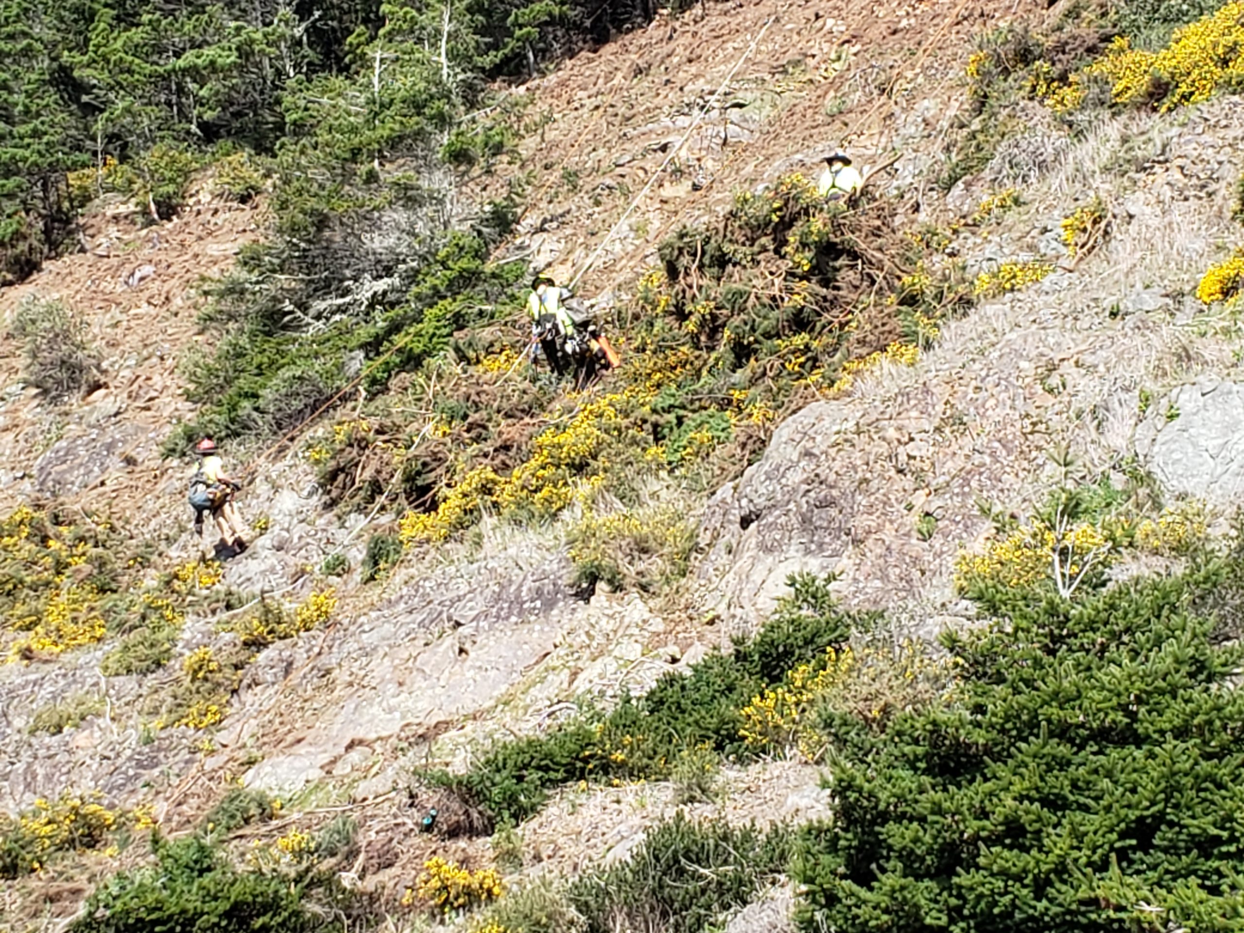
TILLER, Ore. – Crews from the Douglas Forest Protective Association responded to a natural cover fire located approximately 4 miles north of Tiller, Tuesday afternoon. The Marshall’s Place Fire is estimated to be around 200 acres in size, however, more accurate mapping will be conducted in the coming days. No homes have been threatened by the Marshall’s Place Fire and the cause of the fire is currently under investigation.
Firefighters arrived on scene of the Marshall’s Place Fire shortly after 3:00 PM and reported that it was approximately 70 acres in size, burning in logging slash and second growth timber. Strong, gusty winds fanned the flames, resulting in numerous spot fires which accelerated the fire’s growth.
Nine engine crews, three water tenders, two bull dozers, and numerous industrial landowner representatives worked through the afternoon to construct containment lines around the perimeter of the fire. Three 20-person hand crews were ordered to assist with suppression efforts last night.
Firefighters took advantage of favorable conditions overnight and made good progress towards containing the blaze. Crews reported that fire activity significantly decreased Tuesday evening after sunset due to increased humidity levels and decreased wind speeds. Hand crews and bull dozers assigned to the incident continued to work on the fire overnight and completed containment lines around the entire perimeter of the Marshall’s Place Fire by early Wednesday morning.
Today, 110 personnel from the Douglas Forest Protective Association, Oregon Department of Forestry, Coos Forest Protective Association, industrial landowners, and private contractors are assigned to the fire. Crews and equipment will be focused on mopping up hot spots within the perimeter of the fire in addition to holding and improving containment lines. Smoke from the interior of the fire may be visible for the next couple days.
###
Contact: Kyle Reed
Phone: 541-672-6507 X 136 (office) or 541-817-7186 (cell)
E-Mail: kyle.reed@oregon.gov

Engines responding

Firefighter initial response

Column day 1


Portable tank
April 20, 2021
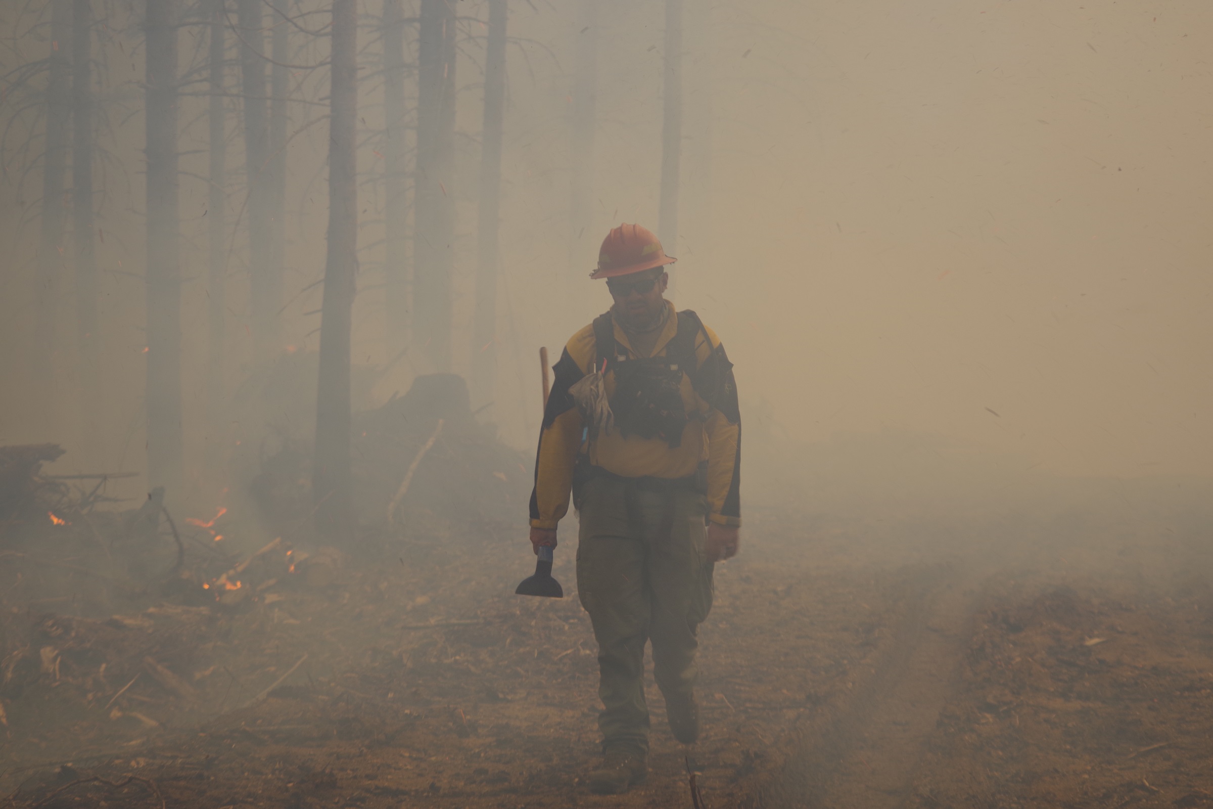
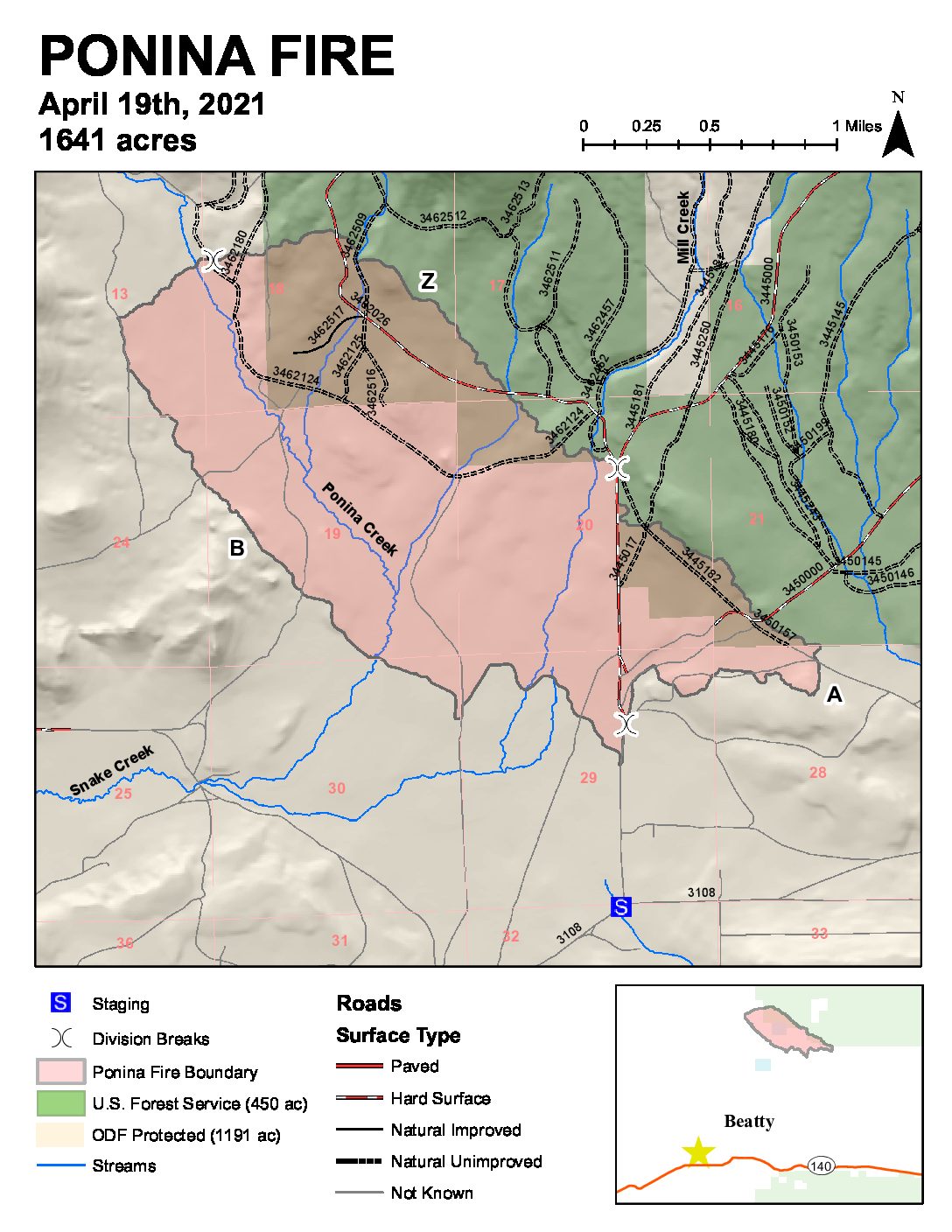
BLY, Ore. – Firefighters continue to make excellent progress on the Ponina Fire burning approximately 5 miles north of Beatty.
The fire is 1,641 acres and 40 percent contained. The cause is under investigation. The fire was reported Sunday around 2:30 p.m.
The increased acreage is due to more accurate mapping. Firefighters yesterday were able to hold the fire and there was no additional growth. They were able to start mop-up activities which will continue today.
The local Type 3 Incident Management Team and firefighters appreciate the local communities who have been extremely helpful and supportive during the Ponina Fire.
The fire is burning in timber and brush with creeping and smoldering fire behavior. There are some interior heavy fuels burning as well as formerly green islands.
There are two handcrews, eight engines, one dozer, one water tender, and one helicopter working on the fire.
There was minimal rain over the fire area last night and this morning. Weather conditions are expected to be cooler today with a chance of showers before noon. Drying northeast winds are expected over the fire this afternoon with temperatures warming again over the coming days.
Seven structures were lost, which were mostly outbuildings. Evacuation levels have been dropped to Level 2 and area residents are able to return if they want but should be prepared to evacuate if conditions change. Evacuations are being conducted by Klamath County Sheriff’s Office.
Smoke is highly visible in the surrounding area, including Oregon State Highway 140. There will be increased fire traffic in the area, including on Hwy 140 and the Sycan Road. Travelers in the area should use caution, reduce speed and be prepared for possible delays.
The fire is burning in an area with narrow roads. The public is advised to avoid the fire area for public and firefighter safety.
Even with cooler weather and some precipitation, fuels remain dormant and dry, meaning fire can carry quickly. As cold fronts approach, winds can be fast and erratic, leading to spotting and rapid fire spread even from a small fire like a campfire. The public is urged to use extreme caution with fire on private and wildlands, especially as the area is already seeing early wildfires.
# # #
South Central Oregon Fire Management Partnership provides comprehensive wildland fire services to more than eight million acres of land administered by the Oregon Department of Forestry Klamath-Lake District; Bureau of Land Management Lakeview District; Fremont-Winema National Forest; U.S. Fish and Wildlife Service’s Sheldon-Hart Mountain National Wildlife Refuge Complex; and Crater Lake National Park. The area encompasses federal, state, and private lands within south central Oregon and northwest Nevada.
April 14, 2021
SALEM, Ore. – The Oregon Department of Forestry is putting to work the $5 million it was granted in January by the Oregon Legislative Emergency Board (E-Board) for reducing wildfire risk. The agency has lined up 37 projects that rely on partnerships to improve community resilience to wildfire and restore and maintain healthy, resilient forests. The projects are spread evenly on both sides of the Cascades. Most of those in western Oregon – 16 out of 19 projects – are concentrated from Lane County to the California border, where wildfire risk near populated areas is generally higher.
“The funds from the Emergency Board provide the state with an incredible opportunity to bring together public and private groups to complete some critical fuels mitigation work in advance of the 2021 fire season,” said Oregon State Forester Peter Daugherty. “This is shared stewardship in action. When we work together, we can treat more acres across ownership boundaries and have a greater impact on fire resiliency in communities and forests throughout the state.”
Partners in the department’s efforts include forest collaboratives, watershed councils, the Northwest Youth Corps, OSU, private landowners, counties, federal agencies, and the Confederated Tribes of the Grand Ronde.
After receiving the funds in January, ODF put out a call for proposals and received 93 applications totaling over $20 million. The 37 projects were chosen from among those applications.
ODF expects that the projects collectively will result in:
- Over 7,000 acres being treated for fuel reduction, including use of prescribed fire
- 1,400 hours of volunteer work
- 750 trees felled in fuel-reduction projects repurposed as logs for in-stream habitat restoration
- 500 hours of young adult training
- 20 miles of right-of-way fuel mitigation treatments
- 10 miles of hiking trails repaired after being damaged by Labor Day wildfires
- 1 post-fire effects study
Some 35 of the 37 projects involve direct treatments on the land. ODF and its partners will employ various fuel treatment methods ranging from ODF fuel crews, landowner cost shares and rebates and/or contracted equipment services.
In addition to funding fuel-treatment projects, ODF is directing investments to increase its organizational capacity, including equipment and full-time staff.
ODF Partnership and Planning Program Manager Jeff Burns said the funding will also allow ODF to increase its organizational capacity through equipment and adding a few full-time staff. “We’re hiring six field-based positions to address local capacity needs and two Salem administrative positions, which will support field operations. This is important given the increasing complexity of cross-boundary programs with multiple partners and funding sources.”
Burns said the field positions allow ODF to keep seasonal firefighters engaged outside of peak fire months. “That’s already paid off in central Oregon because we had trained firefighting staff doing fuels treatment work when a large wildfire was reported in late March. They were able to join the response, adding to our initial attack capability even as they reduce potential fire intensity with their fuels treatment.”
Burns added that ODF leverages significantly more federal funds than it receives in state general funds. Modest and consistent investment in forest restoration has resulted in considerable federal funding entering the state through grant programs, Good Neighbor Authority agreements and conservation partnerships.
# # #


