June 30, 2021
Central Oregon Interagency Dispatch Update – June 30, 9:30 p.m.
Central Oregon – Firefighters have responded to 18 new fires across Central Oregon in the past 24 hours, the largest of which is the Wrentham Market Fire currently estimated at 10,000 acres east of Dufur in Wasco County.
The Wrentham Market Fire was reported on June 29 at 1:30 p.m. on unprotected lands in the Columbia Rural Fire Protection District. The fire is now threatening approximately 20 structures. The fire is mostly burning through wheat and brush and moving towards the Deschutes River. The Wasco County Sheriff’s Office issued Level 3 evacuation notices yesterday for homes in the area impacting 70-100 people.
The Rattlesnake Fire burned approximately 100 acres on the Warm Springs Reservation in grass, brush and juniper before jumping the Deschutes River and growing to an estimated 1,500 acres on Prineville BLM managed lands, moving northeast towards Highway 97. The Rattlesnake Fire is now under the unified command of Warm Springs Incident Commander Lionel Smith and Type 3 Central Oregon Fire Management Service (COFMS) Incident Commander Chad Schmidt. Four large air tankers, two Single Engine Air Tankers (SEATs), a heavy helicopter, are responding to the blaze in addition to the Central Oregon Rappellers and Redmond Hotshots.
The Ryegrass Fire is estimated at 100 acres and is east of the Maury Mountain and south of the Paulina Highway on Prineville District BLM lands. A hotshot crew and 3 engines are responding. The fire is 0% contained at this time.
Firefighters are also responding to a new incident (#460) near Pringle Falls Campground northwest of La Pine on the Deschutes National Forest. La Pine Rural Fire Protection District is engaged in structure protection while Forest Service engines and crews work to contain the fire. There is no estimate on size or containment at this time.
Lightning is forecasted to continue through midnight (12:00 a.m.) and crews continue to respond to smoke reports and pick up new starts across Central Oregon tonight.
For up-to-date information on Central Oregon fires, visit www.centraloregonfire.org or www.twitter.com/CentralORFire
June 30, 2021
News release from the Governor’s office:
Media Contact:
Liz Merah, 503-877-8287
Salem, ORE. — Governor Kate Brown today invoked the Emergency Conflagration Act in response to the Wrentham Market Fire that broke out in Wasco County Tuesday evening. The fire is estimated to be 10,000 acres in size and is located outside Dufur, where residents are on level 3 evacuation in parts of the city. The Office of the State Fire Marshal assumed command at 9 a.m. today, and will work to bring resources from counties around Oregon to assist in the response.
“With high temperatures and weather conditions helping fires grow quickly, I have invoked the Emergency Conflagration Act to make more state resources available to the fire crews on the front lines in Wasco County at the Wrentham Market Fire,” Governor Brown said. “I want to reiterate that preventing wildfires is critical this year, especially as we already have entered an early season with several fires burning across the state. I’m asking all Oregonians to be cautious, be safe, and to honor all burn bans.”
In accordance with ORS 476.510-476.610, Governor Brown determined that a threat to life, safety, and property exist due to the fire, and the threat exceeds the firefighting capabilities of local firefighting personnel and equipment.
The Governor’s declaration cleared the way for the State Fire Marshal to mobilize firefighters and equipment from other jurisdictions to assist local resources battling the fire.
The Office of the State Fire Marshal’s Red Incident Management Team has been mobilized. In addition, three structural task forces are mobilizing from Multnomah, Washington, and Yamhill Counties. OSFM personnel is responding with a Communications Unit and a cache trailer loaded with incident support supplies, including COVID-19 PPE, tools to enhance defensible space around structures, and other provisions firefighters need to inhabit a fire camp.
Additional updates for the incident may be accessed at:
June 30, 2021
News release from the Governor’s office:
Media Contact:
Liz Merah, 503-877-8287
Salem, ORE. — Governor Kate Brown yesterday declared a state of emergency due to the imminent threat of wildfire across Oregon. On the heels of record-breaking high temperatures, much of the state is in high or extreme fire danger with red flag warnings in effect for hot, dry, windy conditions and dry thunderstorms. With the extended forecast in Oregon calling for unseasonably high temperatures with no rain in the forecast—and with 19 counties already in declared drought emergencies—the threat of wildfire in Oregon is imminent.
“Oregon is still recovering from the devastation of last year’s wildfires, which resulted in nine Oregonians losing their lives and thousands more losing their homes,” said Governor Brown. “With wildfires already sparking this year, it is imperative that we act now to prevent further loss—of life, property, business, and our natural resources.
“I issued this emergency declaration to ensure every resource is made available for firefighting efforts and to the crews striving to protect our state. With fire seasons increasingly starting earlier and lasting longer, it is up to each of us to do our part to prevent wildfires and be prepared for the ones we can’t prevent. I am urging Oregonians to take charge in preventing human-caused fires by being prepared, safe, responsible, and aware.”
Firefighters and first responders face a number of additional complexities this year including active wildfire recovery operations such as hazard tree removal and rebuilding that impact roadways and access points. Extreme heat adds to the already challenging firefighting landscape.
Pursuant to ORS 401.165 et seq, Governor Brown determined that a threat to life, safety, and property exists due to the imminent threat of wildfire. The Governor’s declaration authorizes the Oregon Department of Forestry and the Oregon Office of the State Fire Marshal, in coordination with the Oregon Office of Emergency Management, to utilize personnel, equipment, and facilities from other state agencies in order to respond to or mitigate the effects of the wildfire emergency.
The declaration allows state agencies to temporarily suspend any rules that impair the response to wildfires, if needed, and also allows the state to request assistance from other states through the Emergency Management Assistance Compact if necessary. The emergency declaration is focused on helping to ensure that the state is prepared to marshal all available and necessary resources as quickly as possible as wildfires arise during this wildfire season.
When state and national resources are limited, the Oregon National Guard will deploy firefighting resources in accordance with Operations Plan Smokey 2021.
June 30, 2021
Joint news release from South Central Oregon Fire Management Partnership:
Oregon Department of Forestry
www.oregon.gov/odf
BLM Lakeview District
www.blm.gov/office/lakeview-district-office
Fremont-Winema National Forest
www.fs.usda.gov/fremont-winema
Sheldon-Hart Mountain & Klamath Basin National Wildlife Refuge Complexes
www.fws.gov/refuge/Hart_Mountain
www.facebook.com/KlamathBasinRefuges/
LAKEVIEW, Ore. – Fire Danger is being raised to “Extreme” this Wednesday morning for all federal, state, county and private lands in Klamath and Lake counties protected by the agencies of the South Central Oregon Fire Management Partnership (SCOFMP), and increased fire restrictions are going in place. The public is encouraged to be aware of the current regulations before working or recreating on wildlands in Klamath and Lake Counties.
The Fire Danger includes all private, county and state wildlands protected by the Oregon Department of Forestry (ODF) Klamath-Lake District. It also applies to the Fremont-Winema National Forest, the Bureau of Land Management (BLM) Lakeview District, Crater Lake National Park and the Sheldon-Hart Mountain and Klamath Basin National Wildlife Refuge Complexes.
While it’s much earlier than normal, fuel conditions and weather in Klamath and Lake counties has reached “Extreme” Fire Danger. Fires under “Extreme” conditions start quickly, spread furiously, and burn intensely.
At 12:01 a.m. Wednesday, June 30, the federal agencies are going into Public Use Restrictions. ODF Klamath-Lake District began a Public Regulated Use Closure on June 11. Fire officials are putting these restrictions into effect to dramatically reduce the chance of an accidental fire start.
With an early start to fire season, drought conditions, hot temperatures, and winds, it doesn’t take much of a spark or heat to start a fire which can grow several acres in minutes.
There are several common restrictions between the state and federal Public Use Restrictions. The following activities are prohibited on all private, county, state, and federal wildlands:
- Smoking is prohibited except within an enclosed vehicle or building.
- Use of all fireworks is prohibited.
- Use of motor vehicles, including motorcycles and all-terrain vehicles where vegetation comes into contact with the vehicle is prohibited, except on improved roads.
- Open fires are prohibited, including campfires, charcoal fires, cooking fires and warming fires, except at designated locations. Portable cooking stoves using liquefied or bottled fuels are allowed.
- Welding or operating an acetylene or other torch with open flame.
While there are many similarities between all five fire precaution orders, there are differences, including exceptions to these prohibitions in each. The public is responsible for ensuring that they have reviewed and are aware of the restrictions in place for the landscape they plan to recreate or work on.
For all agencies, violation of these prohibitions could result in citations, fines, and even imprisonment, depending on the agency and order.
For more information on the Public Regulated Use Closure, please visit https://www.oregon.gov/odf/fire/pages/restrictions.aspx.
For more information on the federal agency Public Use Restrictions and Fire Prevention Orders, please visit https://scofmp.org/restrictions.shtml.
The Industrial Fire Precaution Level (IFPL) is being raised to a Level III Partial Shutdown on federal lands, specifically Forest Service and BLM. Under IFPL III Partial Shutdown, the following are prohibited except as indicated:
- Cable yarding – Except that gravity operated logging systems employing nonmotorized carriages may operate between 8 p.m. and 1 p.m. When all blocks and moving lines are suspended 10 feet above the ground except the line between the carriage and the chokers.
- Power saws – except power saws may be used at loading sites and on tractor/skidder operations between the hours of 8 p.m. and 1 p.m. local time.
In addition, the following are permitted to operate between the hours of 8 p.m. and 1 p.m. local time:
- Tractor, skidder, feller-buncher, forwarder, or shovel logging operations where tractors, skidders, or other equipment with a blade capable of constructing fireline are immediately available to quickly reach and effectively attack a fire start;
- Mechanized loading or hauling of any product or material;
- Blasting;
- Welding or cutting of metal;
- Any other spark emitting operation not specifically mentioned.
Commercial woodcutters and other members of industry are reminded of their responsibility to stay informed of current IFPLs and all restrictions that apply to activities conducted on public lands. Failure to comply with precautionary fire requirements may result in the issuance of a Violation Notice.
For more information on IFPL restrictions, including those specific to industry, please visit https://scofmp.org/ifpls.shtml.
Anyone going out into wildlands should be prepared with water and/or a fire extinguisher, and shovel. Campfires should never be left unattended. Drown the campfire, stir, and repeat until fire is dead out and cold to the touch before leaving. Suspected wildfires should be reported immediately to 911.
South Central Oregon is already seeing an active and early fire season. In addition to being careful with anything that can spark a fire, private landowners can create and maintain defensible space around structures, especially in rural and forested areas. Residents living in the wildland urban interface should also think about evacuation preparation before wildfires start. Visit https://www.ready.gov/wildfires for more information.
South Central Oregon Fire Management Partnership provides comprehensive wildland fire services to more than eight million acres of land administered by the Bureau of Land Management Lakeview District; Fremont-Winema National Forest; Oregon Department of Forestry Klamath-Lake District; U.S. Fish and Wildlife Service’s Sheldon-Hart Mountain National Wildlife Refuge Complex; and Crater Lake National Park. The area encompasses federal, state, and private lands within south central Oregon and northwest Nevada.
June 29, 2021
La Grande, ORE. – As the weather heats up around the region, fire managers are concerned about the potential for human-caused fires. Fuel conditions have reached levels that firefighters do not normally contend with until much later in the summer. The indices or measurements that firefighters use to estimate fire potential are setting records for this time of year. With these record-setting conditions, Oregon Department of Forestry is reminding everyone to use extreme caution when heading out this Fourth of July weekend.
“Our measurements of fire danger are currently setting new records. This is significant given the time of year. Our charts are showing conditions more aligned with what we expect to see in August. It is very dry out there. It looks like it could be a long fire season for our folks, and we need help from everyone to set a pace that we can keep up with.” said Logan McCrae, La Grande Unit Forester.
The fuel conditions combined with a nationwide draw on firefighting resources have fire managers worried about additional starts. The weather forecast for this week and weekend which is calling for continued hot and dry conditions with a high probability of lightning later in the week and throughout the weekend is causing additional worry.
“There’s a good chance we will already be fighting fire due to the lightning that is forecasted. At this point, we need everyone to be extra cautious as they head out to camp or enjoy the woods this weekend. Leaving the fireworks home, avoiding parking in tall grass, and carrying a few firefighting tools with you are all recommended. Remember, campfires are prohibited except in designated locations.” stated McCrae.
The Oregon Department of Forestry Public Use Restrictions, or Regulated Use Closure, is in effect. These restrictions are geared toward preventing the human-caused starts. These restrictions include but are not limited to: Prohibiting the use of fireworks, campfires (except in designated locations), open burning, and the non-industrial use of chainsaws between the hours of 12:00 p.m. and 8 p.m. Portable cooking stoves using liquified or bottled fuels are allowed. Smoking is prohibited except in vehicles on improved roads, in boats on the water, or at a cleared area free of flammable vegetation. For information on other restrictions that are in effect, please call the ODF Fire Prevention line at (541) 975-3027 or visit: www.bmidc.org/restrictions/
http://bluemountainfireinfo.blogspot.com/ is your spot for current fire information in the Blue Mountains. To report a fire, call Blue Mountain Interagency Dispatch at (541)963-7171 or dial 9-1-1.
June 28, 2021
National: Preparedness Level 4 (Geographic areas competing for wildland fire suppression resources. Three or more geographic areas experiencing large, complex fires.)
|
# of fires |
Acres burned |
| Total to date |
30,219 |
1,389,087 |
Oregon: Preparedness Level 3 (Fire activity is increasing)
| Only ODF-protected lands (16 million acres) |
| |
# of fires |
Acres burned |
| 2021 year-to-date |
425 |
7,543 |
10-year avg. year-to-date
(2011 – 2020) |
231 |
1,859 |
| All lands in Oregon (Includes ODF-protected lands) |
| |
# of fires |
Acres burned |
| 2021 year-to-date |
673 |
22,652 |
Current large fires in Oregon: Includes all lands
| Name |
Date |
Total Acres |
ODF Acres |
Containment |
Location |
Cause |
Notes |
| Cutoff |
June 19, 2021 |
1,288 |
1,000 |
96% |
6 mi. N of Bonanza |
Unknown |
ODF Incident Management Team 1 demobilized 6/27. All evacuations lifted. Final update unless significant activity.
Fire information |
| S-503 |
June 18, 2001 |
4,300 |
700 |
95% |
5 mi. SW of Pine Grove |
Unknown |
NW Team 8 demobilizing 6/27. Moderate fire behavior. Evacuations. Final update unless significant activity.
Fire information |
More information:
Record-setting heat wave exacerbates drying effect, with relative humidity dropping into the teens. Extreme heat expected to moderate Wednesday, but remain above normal for some time. Easterly winds over Cascades will bolster warming and drying on the west side. Potential for isolated afternoon/evening thunderstorms as early as Tuesday and into the weekend. This results in continued elevated fire potential with possible flareups over central Oregon. Lightning poses increased risk as does fireworks use associated with Independence Day holiday.
June 27, 2021
Joe Hessel, Incident Commander
Cutoff Fire email: Cutoff.Fire.Information@gmail.com
Cutoff Fire Information Line: 971-600-2579 (7 a.m. – 10 p.m.)
Facebook: Cutoff Fire
Evacuation Information
Inciweb
Containment hits 96%; all evacuations lifted on the Cutoff Fire
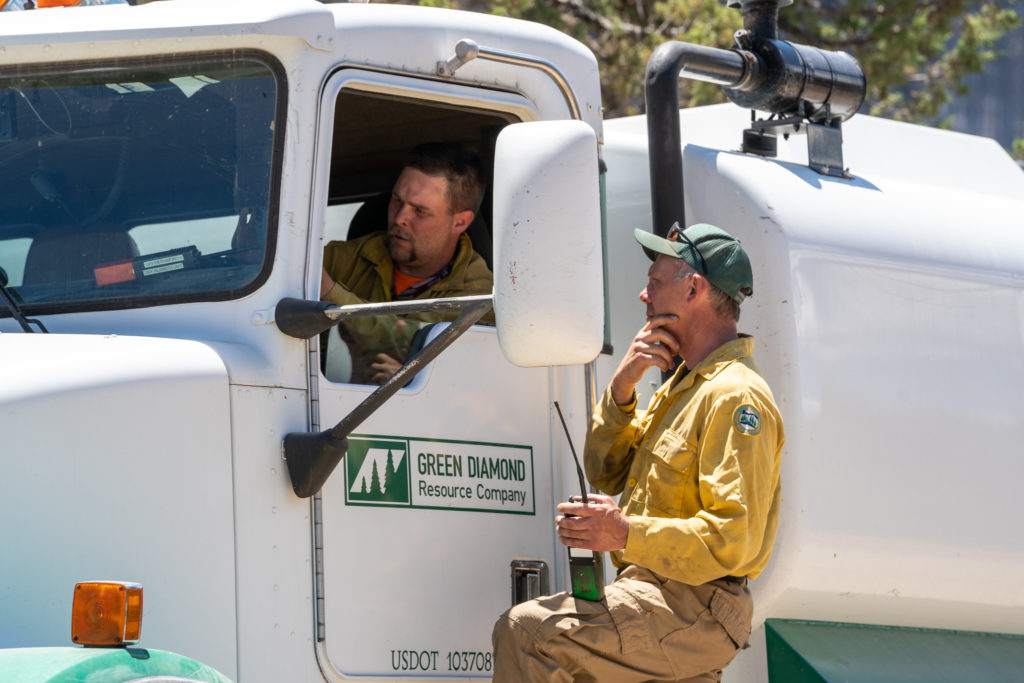
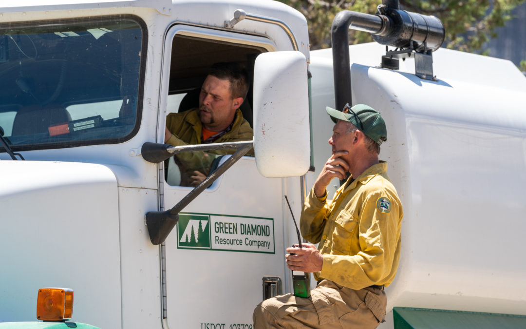
Alpha Division Supervisor Brett O’Nion with ODF talks with a driver of a water tender during the Cutoff Fire.
BONANZA, Ore.— Containment on the Cutoff Fire has reached 96% and the remaining Level 1 (GET READY) evacuation has been lifted for all areas near the fire effective 8:00 a.m. on Sunday June 27, 2021.
ODF Incident Management Team 1 will hand back responsibility for the Cutoff Fire to local ODF, BLM, and Forest Service units Sunday at 8:00 a.m. The local agencies will ensure the fire is monitored and patrolled over the coming heat wave and throughout the summer.
With containment nearly complete Joe Hessel, Cutoff Fire Incident Commander said, “There is little chance of the fire escaping but it still needs to be monitored and patrolled especially through the expected hot weather.” The group taking command of the fire will patrol the fire’s edge, grid for residual heat, and keep the fire’s perimeter secure during the expected heat wave.
“New fires have started in the surrounding area almost every day during this incident. I’m pleased we were able to quickly take care of this fire and put resources back into the system so they can be available for the next fire,” said Hessel.
The forecast calls for record breaking heat. ODF and its partner agencies encourage everyone to be fire safe and stay hydrated.
This will be the final update on the Cutoff Fire from ODF’s Incident Management Team 1. Future fire information will be shared via Facebook and Inciweb.
| Estimated Size: |
1,288 acres |
| Containment: |
96% |
| Start Date/Time: |
6/19/2021 at 1:29 p.m. |
| Anticipated Containment Date: |
6/29/2021 |
| Location: |
6 miles north of Bonanza |
| Cause: |
Under investigation |
| Personnel: |
208 |
| Assigned Resources
Hand Crews:
Engines:
Dozers:
Water Tenders:
Other Heavy Equipment: |
5
6
1
2
2 |
| Assigned Aircraft:
Structure Task Forces: |
2
0 |
| Injuries: |
1 |
| Structures Threatened: |
0 |
| Structures Damaged: |
0 |
| Structures Destroyed: |
22 |
| Evacuations: |
0 |
June 26, 2021
Oregon Department of Forestry IMT 1, Joe Hessel, Incident Commander
Cutoff Fire email: Cutoff.Fire.Information@gmail.com
Cutoff Fire Information Line: 971-600-2579 (7 a.m. – 10 p.m.)
Facebook: Cutoff Fire
Evacuation Information
Inciweb
Local ODF district to take control of Cutoff Fire on Sunday
BONANZA, Ore.— Containment on the Cutoff Fire has reached 85 percent. Incident Management Team 1 will officially hand back responsibility for the Cutoff Fire to ODF’s Klamath-Lake District, BLM and US Forest Service Sunday morning at 8 a.m. The District will ensure the fire is monitored and patrolled over the summer.
Mike Carlson, Operations Section Chief with Incident Management Team 1, reminded the final firefighting shift to thoroughly mop up any residual heat near the fire’s edge. “There have been cases where mop-up was incomplete and a week after crews left the fire rekindled and started a new fire. Our goal is to ensure that the Cutoff Fire stays secure through the long hot summer ahead.”
A small force of firefighters who worked to put out the fire will remain to conduct patrols, back haul equipment, and repair any damage from suppression activities. Hundreds of firefighters and equipment that helped contain the Cutoff Fire will leave the fire today for a well-earned short break or reassignment elsewhere.
The fire started a week ago six miles north of Bonanza and 20 miles east of Klamath Falls. It burned 1,288 acres, destroyed 22 structures including two residences and caused temporary evacuations and road closures.
Area residents are cautioned that roads between the fire and Bonanza could see heavy traffic at times as emergency vehicles leave. Reducing speed is advised.
| Estimated Size: |
1,288 acres |
| Containment: |
85% |
| Start Date/Time: |
6/19/2021 at 1:29 p.m. |
| Anticipated Containment Date: |
6/29/2021 |
| Location: |
6 miles north of Bonanza |
| Cause: |
Under investigation |
| Personnel: |
398 |
| Assigned Resources
Hand Crews:
Engines:
Dozers:
Water Tenders:
Other Heavy Equipment: |
11
18
2
8
7 |
| Assigned Aircraft:
Structure Task Forces: |
5
0 |
| Injuries: |
1 |
| Structures Threatened: |
0 |
| Structures Damaged: |
0 |
| Structures Destroyed: |
22 |
| Evacuations: |
0 |
June 26, 2021
Northwest Incident Management Team 8, Incident Commander, Kevin Stock
Northwest Incident Management Team 8 (NWIMT8) will meet the incident objectives at the end of the work shift on Sunday. NWIMT8 will transition to a smaller fire management organization on Monday morning. Fire Updates will be distributed once daily with additional information provided throughout the day via Facebook and Inciweb. The S-503 Fire is located in timber and grasses on the Confederated Tribes of the Warm Springs Reservation and privately owned in-holdings protected by the Oregon Department of Forestry. This fire is being managed as a full suppression fire.
Fire Information: (541) 670-0812 (8:00 a.m. to 9:00 p.m.) or (541) 553-2004 (8:00 a.m. to 9:00 p.m.)
E-mail: 2021.S-503@firenet.gov
Information Websites:
Facebook page “CTWS – Fire Management”
Inciweb information on https://inciweb.nwcg.gov/incident/7559
Oregon Smoke Information – http://oregonsmoke.blogspot.com/
Acreage: 6,679 (approximately 535 acres is private in-holdings protected by the Oregon Department of Forestry).
Containment: 60%
General Updates: The National Weather Service has issued an “Excessive Heat Warning.” Firefighters are well informed with extra guidance for heat-related illnesses, watch-out situation metrics and cooling tents to care for the firefighters during the anticipated record temperatures.
The footprint of the S-503 Fire remains the same. Firefighters are continuing to mop-up areas of heat to the provided mop-up standards to create a cold, black rind around the fire’s edge. This buffer will secure the fire from moving out of the existing footprint.
Firefighting resources from the S-503 Fire assisted in a response to a new fire start yesterday, the B-270 Fire, on the Confederated Tribes of the Warm Springs Reservation. A variety of different firefighting resources are prepared to respond to new starts today.
Weather: Temperatures will continue to rise over the next several days to historic highs. Today will be sunny and hot with temperatures near 97 degrees in the lower elevations and 90 degrees around 3,200 ft. Minimum relative humidity is forecast for 20 – 25% with northeast winds 7-14 mph with gusts to 25 mph in the afternoon.
Resources: 521 Total: 2–type 1 hotshot crews, 5-type 2 initial attack crews, 5-type 2 hand crews, 2-camp crews, 2-heavy helicopters, 1-light helicopter, 38-engines, 6-dozers, 15-water tender, 4-skidgines, and 99 overhead.
Closures and Evacuations: Evacuation Level 1 – Get Set, as determined by the Wasco County Sheriff’s Office remains for all residences west of Kelly Springs Rd/Back Walters Rd plus anything east of Kelly Springs to Reservation Rd, including Walters Corners and the community of Pine Grove.
Temporary Flight Restrictions: For the safety of the firefighters and aircraft fighting the S-503 Fire, a temporary flight restriction has been placed over the fire area. Please consult the “Notice to Airman” for specifics. Wildfires are a “No Drone Zone.”
June 25, 2021
The Dalles, Ore. – Firefighters responded to three fires Friday morning burning adjacent to Interstate 84 near Rowena, while working to put these fires out two additional starts were discovered along the freeway. These fires, named the Milepost 78 Fire, burned grass, brush and timber primarily within Mayer State Park protected by the Oregon Department of Forestry (ODF). The three larger fires burned approximately seven acres between I-84 and the railroad tracks, the other two fires were limited to a “spot.” When resources arrived the fire was running, spotting and torching with 8-10 foot flame lengths at the head of the fire. This fire behavior was mitigated by numerous water drops from Fire Boss aircraft. Moderating fire behavior with the water drops allowed firefighters on the ground to engage the fire and begin fire line construction.
In addition to the two Oregon Department of Forestry Fire Boss aircraft, a Type 1 helicopter on loan from the S-503 Fire, and an air attack platform from Central Oregon Fire Management Services engaged in the fire suppression effort. The fire was managed in Unified Command between Oregon Department of Forestry and Mid-Columbia Fire and Rescue.
“The Fire Bosses were critical for keeping the fires north of the highway and protecting numerous structures in Rowena,” says Rick Fletcher, Incident Commander for ODF.
Tonight, the fire is 20% contained with fire line nearly complete around the perimeter. Overnight Mid-Columbia Fire and Rescue will provide patrols to ensure the fire does not move outside the fire line. Tomorrow two engines, one crew, one faller, and overhead will be working to secure the fire.
Evacuation information is available from the Wasco County Sheriff on their facebook page: www.facebook.com/WascoCountySheriff. One westbound lane of the freeway remains closed due to firefighting activity. Drivers should use caution in the area due to heavy congestion.
Two contract hand crews, an ODF crew, engines and overhead from Columbia River Gorge National Scenic Area, BLM Prineville, Wasco County Sheriff’s Office, Oregon State Police, and Oregon Department of Transportation were involved in suppression of the fire and ensuring public safety. Fire departments across the Columbia Gorge also provided resources to the fire fighting effort, working to protect their community. These departments include Mid-Columbia Fire and Rescue, Dufur, Mosier, Dallesport, Hood River, Cascade Locks, Westside, Wy’East, and Parkdale.
The cause of the fire is under investigation at this time.
Regulated-Use Closure is in effect for the Oregon Department of Forestry. Mowing of dried grass and chainsaw use is restricted between the hours of 10 a.m. and 8 p.m. Additional restrictions can be found at www.odfcentraloregon.com.
June 25, 2021
SALEM, Ore. – All Oregon Department of Forestry protected lands are now in fire season. ODF’s 12 fire-protection districts start, and end fire season based on local conditions. Fire season means certain activities are restricted to help prevent human-caused wildfires. Fire season generally ends in mid-October. The North Cascade District was the last to declare fire season. The Southwest Oregon District led off, declaring its start on May 12.
Debris burning is a leading cause of wildfires. Generally, fire season means no more debris burning, although burn permits may be issued in certain situations. Burning without a permit can lead to a citation. Violators are held liable for firefighting costs if their debris burn escapes.
Fire season restricts other activities too. Fire season laws limit or prohibit campfires, mowing grass, cutting metal and welding, using power saws, and other spark-causing activities. For example, during low fire danger level, mowing may be allowed. But, during moderate, high, and extreme fire danger, mowing may be restricted or prohibited. Protection districts determine restrictions based on fire danger. During fire season it is illegal to use fireworks, tracer ammunition, and exploding targets on ODF-protected and other state and federal lands.
Stay informed of current restrictions by visiting ODF’s Fire Restrictions & Closures website or calling your local ODF office. To learn more about preventing human-caused wildfires, visit Keep Oregon Green.
ODF protects over 16 million acres of private, county, state, and federal land from wildfire.
June 25, 2021
Northwest Incident Management Team 8, Incident Commander, Kevin Stock
The S-503 Fire is located in timber and grasses on the Confederated Tribes of the Warm Springs Reservation and privately owned in-holdings protected by the Oregon Department of Forestry. This fire is being managed as a full suppression fire.
Fire Information: (541) 670-0812 (8:00 a.m. to 9:00 p.m.) or (541) 553-2004 (8:00 a.m. to 9:00 p.m.)
E-mail: 2021.S-503@firenet.gov
Information Websites:
Facebook page “CTWS – Fire Management”
Inciweb information on https://inciweb.nwcg.gov/incident/7559
Oregon Smoke Information – http://oregonsmoke.blogspot.com/
Acreage: 6,679 (approximately 535 acres is private in-holdings protected by the Oregon Department of Forestry).
Containment: 50%
General Updates: The fire remains in its current footprint. The fire perimeter is completely lined. Firefighters are focusing on strengthing containment lines by mitigating hazard trees so crews can reach farther into the interior of the fire. Mop-up standards call for identifying smokes and hotspots within 100 feet of the fire line in areas of grass and 300 feet in timbered areas. Firefighters observed some increased activity in the interior of the perimeter as pockets of unburned fuels ignited. However, the surface fuels are too light to cause the fire to make a run into the canopy. Two hotshot crews, three engines, and miscellaneous overhead resources from the S-503 Fire responded to assist the Confederated Tribes of the Warm Springs Reservation with two new fire starts on the south end of the reservation. This will not affect the S-503 Fire operational objectives.
Weather: Tonight will be mostly clear with temperatures between 52-58 degrees with evening relative humidity between 60-75 %. Winds will be to northwest 5-8 mph with gusts up to 16 mph in the evening, switching to northwest after 2200 hrs.
Resources: 519: 2–type 1 hotshot crews, 5-type 2 initial attack crews, 5-type 2 hand crews, 2-camp crews, 2-heavy helicopters, 1-light helicopter, 37-engines, 5-dozers, 16-water tender, 3-skidgines, and 98 overhead.
Closures and Evacuations: The Wasco County Sheriff’s Office has lowered all residences west of Kelly Springs Rd/Back Walters Rd to a Level 1 – Get Set. Anything east of Kelly Springs to Reservation Rd, including Walters Corners and the community of Pine Grove, is also a Level 1 – Get Set.
Temporary Flight Restrictions: For the safety of the firefighters and aircraft fighting the S-503 Fire, a temporary flight restriction has been placed over the fire area. Please consult the “Notice to Airman” for specifics. Wildfires are a “No Drone Zone.”
June 25, 2021
JACKSON & JOSEPHINE COUNTIES, Ore. – The fire danger level on lands protected by the Oregon Department of Forestry Southwest Oregon District will increase to “high” (yellow) and the Industrial Fire Precaution Level (IFPL) will increase to Level 2 (two) on Monday, June 28, 2021 at 12:01 a.m. This affects 1.8 million acres of state, private, county and Bureau of Land Management lands in Jackson and Josephine counties.
The primary difference between current fire prevention restrictions and those beginning on Monday affects the public use of power-driven equipment, such as chain saws and mowers. The use of power-driven equipment, grinding, cutting of metal, and other spark-emitting equipment, such as wood splitters and generators, will be prohibited between the hours of 10 a.m. and 8 p.m.
Other fire prevention regulations which will remain in effect, include:
- No debris burning, including piles and debris burned in burn barrels
- No fireworks on or within 1/8th of a mile of forestlands
- Exploding targets and tracer ammunition, or any bullet with a pyrotechnic charge in its base, are prohibited
- Campfires are allowed only in designated campgrounds. Portable stoves using liquefied or bottled fuels may be used in other locations
- Motorized vehicles, including motorcycles and all-terrain, are allowed only on improved roads; one shovel and one gallon of water, or one 2.5 pound or larger fire extinguisher, is required while traveling
- Smoking while traveling will only be allowed in enclosed vehicles on improved roads, in boats on the water and other specifically designated locations
- Chain saws may not be used between 10:00 a.m. and 8:00 p.m. during high fire danger. During hours outside of this time frame, chain saws may be used but require that the operator have one shovel and one 8-oz or larger fire extinguisher at the work site. A fire watch is also required for one hour after each chainsaw use
- Cutting, grinding, and welding of metal is not allowed between 10:00 a.m. and 8:00 p.m. during high fire danger. These activities will be allowed during hours outside of this time frame only if the work site is cleared of potentially flammable vegetation and other materials, and a water supply is at the job site
- The mowing of dead or dried grass with power-driven equipment is not allowed between 10:00 a.m. and 8:00 p.m. during high fire danger. This restriction does not include mowing of green lawns, or equipment used for the commercial culture and harvest of agricultural crops
- Any other spark-emitting internal combustion engine-use not specifically mentioned is not allowed between 10:00 a.m. and 8:00 p.m. during high fire danger. Use of any spark-emitting internal combustion engine is allowed outside of this time frame only if the work site is cleared of potentially flammable vegetation and other materials, and a water supply is at the job site
- Any electric fence controllers must be approved by a nationally recognized testing laboratory, such as Underwriters Laboratories Inc., or be certified by the Department of Consumer and Business Services, and be installed and used in compliance with the fence controller’s instructions for fire safe operation
Under IFPL II (Two) – limited shutdown, which is entirely separate from all public fire restrictions, the following may operate after 8 p.m. and up until 1 p.m. daily:
- Power saws, except at loading sites
- Feller-bunchers with rotary head saws
- Cable yarding
- Blasting
- Welding, cutting, or grinding of metal
For more information about the Oregon Department of Forestry’s fire season public restrictions, please call or visit the Southwest Oregon District unit office nearest to you:
- Medford Unit, 5286 Table Rock Rd., Central Point. (541) 664-3328
- Grants Pass Unit, 5375 Monument Dr., Grants Pass. (541) 474-3152
Fire season information is also available online at our Facebook page, @ODFSouthwest and our website, www.swofire.com.
June 25, 2021
Oregon Department of Forestry IMT 1, Joe Hessel, Incident Commander
Cutoff Fire email: Cutoff.Fire.Information@gmail.com
Cutoff Fire Information Line: 971-600-2579 (7 a.m. – 10 p.m.)
Facebook: Cutoff Fire
Evacuation Information
Inciweb
Containment on Cutoff Fire passes two-thirds mark
BONANZA, Ore.— Hard work pays off. Containment has reached 67% on the Cutoff Fire. There’s been no growth in the fire’s size, which remains at 1,288 acres. The fire is located six miles north of Bonanza and 20 miles east of Klamath Falls.
Today, firefighters will continue mopping up remaining hot spots close to the fire’s edge that were identified Wednesday night by air and ground-based infrared heat detection equipment. Firefighters are digging out stump holes, extinguishing smoldering duff and clearing low-hanging tree limbs.
Crews from the Cutoff Fire were sent to a new fire start east of Bonanza late yesterday to help local firefighters. Together, they stopped the spread of the Painter Fire. This is the fourth time aircraft or ground resources deployed to the Cutoff Fire have responded to new fire starts in the area.
This morning, officials lowered the evacuation levels for the fire area to Level 1 (Get Ready). Residents are advised to plan for how they would evacuate and where they would go if needed.
Incident Meteorologist Tom Wright from the National Oceanic and Atmospheric Administration (NOAA) is forecasting record-breaking triple-digit temperatures at the fire this weekend. “Like much of Oregon, it will be very warm Saturday and we could shatter heat records Sunday,” Wright said. Fire managers are having firefighters pace their work with the heat levels, drink lots of water and take shade breaks as needed to avoid heat-related illnesses.
Firefighting traffic remains heavy in the fire area. Fire managers ask that other drivers in the area stay aware and reduce speeds to accommodate fire-related traffic.
| Estimated Size: |
1,288 acres |
| Containment: |
67% |
| Start Date/Time: |
6/19/2021 at 1:29 p.m. |
| Anticipated Containment Date: |
6/29/2021 |
| Location: |
6 miles north of Bonanza |
| Cause: |
Under investigation |
| Personnel: |
407 |
| Assigned Resources
Hand Crews:
Engines:
Dozers:
Water Tenders:
Other Heavy Equipment: |
11
20
2
8
7 |
| Assigned Aircraft:
Structure Task Forces: |
5
0 |
| Injuries: |
1 |
| Structures Threatened: |
0 |
| Structures Damaged: |
0 |
| Structures Destroyed: |
22 |
| Evacuations: |
0 |
June 24, 2021
Northwest Incident Management Team 8, Incident Commander, Kevin Stock
The S-503 Fire is burning in timber and grasses on the Confederated Tribes of the Warm Springs Reservation and privately owned in-holdings protected by the Oregon Department of Forestry. This fire is being managed as a full suppression fire.
Fire Information: (541) 670-0812 (8:00 a.m. to 9:00 p.m.) or (541) 553-2004 (8:00 a.m. to 9:00 p.m.)
E-mail: 2021.S-503@firenet.gov
Information Websites:
Facebook page “CTWS – Fire Management”
Inciweb information on https://inciweb.nwcg.gov/incident/7559
Oregon Smoke Information – http://oregonsmoke.blogspot.com/
Acreage: 6,679 (approximately 535 acres is private in-holdings protected by the Oregon Department of Forestry).
Containment: 30%
General Updates: For the past 48 hours, the fire has continued to remain in its current footprint. The fire perimeter is completely lined. Firefighters are focusing on securing containment lines by identifying smokes and hotspots within 100 feet of the fire line in areas of grass and 300 feet in timbered areas. Resources from the S-503 Fire will be available to assist the Confederated Tribes of the Warm Springs Reservation with any new fire starts.
Weather: Thursday will be the coolest of the following days with maximum temperatures between 80-85 with afternoon relative humidity between 21-26%. Winds will be light westerly in the morning increasing to to 5-8 mph with gusts up to 25 mph in the afternoon. Thunderstorms are not expected today.
Resources: 472: 2–type 1 hotshot crews, 5-type 2 initial attack crews, 2-type 2 hand crews, 2-camp crews, 2-heavy helicopters, 1-light helicopter, 43-engines, 6-dozers, 16-water tender, 4-skidgines, and 95 overhead.
Closures and Evacuations: The Wasco County Sherriff’s Office has determined all residences west of Kelly Springs Rd/Back Walters Rd remain at evacuation Level 2 – Get Set. Anything east of Kelly Springs to Reservation Rd, including Walters Corners and the community of Pine Grove, also remains at Level 2 – Get Set.
Temporary Flight Restrictions: For the safety of the firefighters and aircraft fighting the S-503 Fire, a temporary flight restriction has been placed over the fire area. Please consult the “Notice to Airman” for specifics. Wildfires are a “No Drone Zone.”
June 24, 2021
Oregon Department of Forestry IMT 1, Joe Hessel, Incident Commander
Cutoff Fire email: Cutoff.Fire.Information@gmail.com
Cutoff Fire Information Line: 971-600-2579 (7 a.m. – 10 p.m.)
Facebook: Cutoff Fire
Evacuation Information
Inciweb
Fire crews mopping up hot spots ahead of coming heat wave
BONANZA, Ore.— Overnight, detection operations were conducted by numerous methods including a drone, a fixed-wing airplane, and ground-based crews, all equipped with infrared heat detection equipment. These are just some of the tools that fire managers are using to ensure the Cutoff Fire is contained.
There has been no fire growth in the past 24-hours. Firefighters have shifted their attention to the mop up process. Mop up consists of intentionally identifying hot spots that could threaten the fire line and extinguishing them. Last night’s infrared detection resources have given firefighters detailed information on where many of these hotspots are.
Firefighting traffic remains heavy in the fire area. Fire managers ask that other traffic in the area stay aware and reduce speeds as they share the roads with firefighters. Fire managers would also like to remind people that hazards remain in and near the fire area, including fire-weakened trees, stump holes filled with hot ash and other hazards.
Forecasts call for temperatures in Klamath County to soar headed into the weekend, reaching at least 100 degrees by Sunday. Fire managers are reminding firefighters to drink plenty of water to avoid heat-related illnesses.
A Level 2 (GET SET) evacuation recommendation remains in effect for the area east of Bly Mountain Cutoff Road, between Jaguar Lane/Raccoon Lane and Spaniel Lane/ Crocodile Lane, west of Thrasher Drive. A Level 1 (GET READY) evacuation notice is in place for other areas.
ODF Incident Management Team 1’s Deputy Incident Commander Eric Perkins praised firefighters today for their work in this phase of the operation. “About 70 percent of what we do as wildland firefighters is put out hot spots near a fire’s edge. It’s not glamorous work but it’s important.”
| Estimated Size: |
1,288 acres |
| Containment: |
41% |
| Start Date/Time: |
6/19/2021 at 1:29 p.m. |
| Anticipated Containment Date: |
6/29/2021 |
| Location: |
6 miles north of Bonanza |
| Cause: |
Under investigation |
| Personnel: |
415 |
| Assigned Resources
Hand Crews:
Engines:
Dozers:
Water Tenders:
Other Heavy Equipment: |
10
20
2
8
7 |
| Assigned Aircraft:
Structure Task Forces: |
5
0 |
| Injuries: |
1 |
| Structures Threatened: |
125 |
| Structures Damaged: |
0 |
| Structures Destroyed: |
22 |
| Evacuations: |
0 |
June 23, 2021
NOTE: This will be the last evening update from the Cutoff Fire.
Oregon Department of Forestry IMT 1, Joe Hessel, Incident Commander
Cutoff Fire email: Cutoff.Fire.Information@gmail.com
Cutoff Fire Information Line: 971-600-2579 (7 a.m. – 10 p.m.)
Facebook: Cutoff Fire
Evacuation Information
Inciweb
Fire Crews Strengthen Control Lines Ahead of Predicted Heat Wave
BONANZA, Ore.—More precise mapping now shows the size of the Cutoff Fire as 1,288 acres. Containment has reached 41%. Firefighters have mopped up all around the fire to a distance of at least 100 feet, and to 150 feet from the edge in some places. Tonight, a drone carrying infrared heat-detection equipment will fly over the fire’s perimeter to identify areas that are still hot and smoldering. Meanwhile, ground crews will use hand-held infrared heat detectors to comb over the fire looking for hot spots that need to be mopped up.
The forecast calls for a heat wave in the area moving into the weekend. Temperatures could reach 100 degrees by Sunday. Fire managers are reminding firefighters to drink lots of water to avoid dehydration and heat stress.
Evacuation levels remain unchanged at Level 2 or 1 in areas near the fire. Residents are allowed to come and go from their properties but are asked to be alert to hazards that remain near burned areas, including heavy fire equipment traffic.
Operations Section Chief John Flannigan expressed appreciation for the progress firefighters have made in cooling hot spots and putting out embers to reduce chances for the fire to escape. “Their work over the next few shifts is to find hot spots that could threaten the control line. It’s important to do this ahead of the gusty winds and hot temperatures predicted for this weekend.”
June 23, 2021
Northwest Incident Management Team 8, Incident Commander, Kevin Stock
The S-503 Fire is burning in timber and grasses on the Confederated Tribes of the Warm Springs Reservation and privately owned in-holdings protected by the Oregon Department of Forestry. This fire is being managed as a full suppression fire.
Fire Information: (541) 670-0812 (8:00 a.m. to 9:00 p.m.) or (541) 553-2004 (8:00 a.m. to 9:00 p.m.)
E-mail: 2021.S-503@firenet.gov
Information Websites:
Facebook page “CTWS – Fire Management”
Inciweb information on https://inciweb.nwcg.gov/incident/7559
Oregon Smoke Information – http://oregonsmoke.blogspot.com/
Acreage: 6,679 (approximately 535 acres is private in-holdings protected by the Oregon Department of Forestry).
Containment: 30%
General Updates: There was no fire perimeter growth today. Acreage reflects the most recently updated mapped data. The entire fire is in full mop-up mode on all perimteres. All smokes and hotspots 300 ft from the fire’s edge in the timber and 100 ft in grass/brush are being located and cooled to meet control objectives. Additonal resources are arriving to assist with the mop-up and suppression operations. Resources from the S-503 Fire will be available to assist the Confederated Tribes of the Warm Springs Reservation with any new fire starts.
Weather: No lightning was received over the fire area today. Tonight will become mostly clear with winds 5 to 7 mph with gusts to 20 mph in the evening. Minimum temperatures will be 49-55 degrees with maximum relative humidity of 65-75 %. The weather pattern is setting to heat-up with historic maximum temperatures predicted for this week-end.
Resources-459: 2–type 1 hotshot crews, 5-type 2 initial attack crews, 2-type 2 hand crews, 2-camp crews, 2-heavy helicopters, 1-light helicopter, 44-engines, 6-dozers, 16-water tender, 3-skidgines, and 92 overhead.
Closures and Evacuations: The Wasco County Sherriff’s Office has determined all residences west of Kelly Springs Rd/Back Walters Rd remain at evacuation Level 2 – Get Set. Anything east of Kelly Springs to Reservation Rd, including Walters Corners and the community of Pine Grove, also remains at Level 2 – Get Set.
Temporary Flight Restrictions: For the safety of the firefighters and aircraft fighting the S-503 Fire, a temporary flight restriction has been placed over the fire area. Please consult the “Notice to Airman” for specifics. Wildfires are a “No Drone Zone.”
June 23, 2021
Northwest Incident Management Team 8, Incident Commander, Kevin Stock
The S-503 Fire is burning in timber and grasses on the Confederated Tribes of the Warm Springs Reservation and privately owned in-holdings protected by the Oregon Department of Forestry. This fire is being managed as a full suppression fire.
Fire Information: (541) 670-0812 (8:00 a.m. to 9:00 p.m.) or (541) 553-2004 (8:00 a.m. to 9:00 p.m.)
E-mail: 2021.S-503@firenet.gov
Information Websites:
Facebook page “CTWS – Fire Management”
Inciweb information on https://inciweb.nwcg.gov/incident/7559
Oregon Smoke Information – http://oregonsmoke.blogspot.com/
Acreage: 6,556 (approximately 535 acres is private in-holdings protected by the Oregon Department of Forestry). The change in acreage numbers is due to more accurate GIS mapping and aerial infra-red imagery.
Containment: 20%
General Updates: Cooler temperatures and higher humidity allowed firefighters to strengthen the containment lines around the S-503 Fire last night. Improvements included patrolling and cooling hotspots along the fire’s edge and creating a 50 foot cold and black perimeter. Today, resources will use direct firefighting tactics where possible. They will concentrate on the timbered areas with residual heat. Resources from the S-503 Fire will remain available to assist the Confederated Tribes of the Warm Springs Reservation with any new fire starts.
Weather: Today’s temperature is forecasted for the upper 80’s with afternoon winds from the west reaching to 20 MPH. The relative humidity is expected to reach 26-30%. Red Flag warnings are posted for areas to the east for abundant lightning. The biggest concern is the possibility of thunderstorms drifting west, causing gusty and erratic winds, along with the chance Firefighters will be kept informed of any developments.
Resources-360: 2 – type 1 hotshot crews, 5-type 2 initial attack crews, 1-heavy helicopter, 1-light helicopter, 39-engines, 6-dozers, 10-water tender, and 76 overhead.
Closures and Evacuations: The Wasco County Sherriff’s Office has determined all residences west of Kelly Springs Rd/Back Walters Rd remain at evacuation Level 2 – Get Set. Anything east of Kelly Springs to Reservation Rd, including Walters Corners and the community of Pine Grove, also remains at Level 2 – Get Set.
Temporary Flight Restrictions: For the safety of the firefighters and aircraft fighting the S-503 Fire, a temporary flight restriction has been placed over the fire area. Please consult the “Notice to Airman” for specifics. Wildfires are a “No Drone Zone.”
June 23, 2021
Oregon Department of Forestry IMT 1, Joe Hessel, Incident Commander
Cutoff Fire email: Cutoff.Fire.Information@gmail.com
Cutoff Fire Information Line: 971-600-2579 (7 a.m. – 10 p.m.)
Facebook: Cutoff Fire
Evacuation Information
Inciweb
Night crew sets day crew up for success
BONANZA, Ore. — Night shift resources made good progress on the fire. Crews worked on containing the 5 acre spot fire from yesterday afternoon. Firefighters also carried out a small, controlled burn of unburned vegetation in the fire’s interior.
Today the plan is to mop-up 150 feet into the fire’s perimeter. Crews will continue to strengthen containment lines until the fire reaches full containment. The biggest threat to spread is hot spots close to the fire’s edge.
Tonight, an infrared drone will fly over the fire to map the hot spots near the fire’s perimeter. This resource maps heat that cannot be seen by the naked eye. Residents in the area may notice this aircraft as it operates after dusk along the perimeter of the fire. Members of the public are not allowed to fly drones near wildfires – if you fly, we cannot!
ODF Incident Management Team 1 held a community meeting last night. The meeting was recorded and is posted on the fire’s Facebook page. Local fire managers and team members spoke at the meeting and answered numerous questions from participants.
Today’s weather is expected to be more moderate with warm, dry, and sunny conditions. There is a chance of thunderstorms today after 3 p.m. The best chance for a thunderstorm will be to the north and east of the fire.
As a reminder there are still evacuations in effect in the area near the fire. A Level 2 (GET SET) evacuation is still in effect for the area east of Bly Mountain Cutoff Road, between Jaguar Lane/Racoon Lane and Spaniel Lane/ Crocodile Lane, west of Thrasher Drive. A Level 1 (GET READY) evacuation notice is in place for other areas. There are still hazards around the fire, so residents are urged to stay vigilant when traveling through the area.
| Estimated Size: |
1,150 acres |
| Containment: |
23% |
| Start Date/Time: |
6/19/2021 at 1:29 p.m. |
| Anticipated Containment Date: |
6/29/2021 |
| Location: |
6 miles north of Bonanza |
| Cause: |
Under investigation |
| Personnel: |
426 |
| Assigned Resources
Hand Crews:
Engines:
Dozers:
Water Tenders:
Other Heavy Equipment: |
10
17
4
8
7 |
| Assigned Aircraft:
Structure Task Forces: |
9
0 |
| Injuries: |
0 |
| Structures Threatened: |
125 |
| Structures Damaged: |
0 |
| Structures Destroyed: |
22 |
| Evacuations: |
237 persons |
