July 9, 2021
Mitchell, ORE. – Due to more accurate mapping, the fire now stands at 368 acres. Containment has reached 45 percent. Full mop-up efforts will continue as crews work to detect and extinguish hot spots.
Today, firefighters will look for pockets of smoldering fuels and occasional isolated flare ups in the far interior of the fire area. Overall, smoke from the fire will decrease due to consumption of residual fuels and aggressive mop-up efforts.
The forecast includes the return of hot temperatures starting today and through the weekend, with a slight cool down next week. Hot temperatures and single digit relative humidity will challenge firefighting activity.
Fire prevention remains a top priority across the region. Fire officials would like to remind the public to follow fire season restrictions and pay particular attention to any spark emitting activities such as campfires, small equipment use and off-road driving.
Current fire restrictions and information for ODF’s Central Oregon District is available at www.odfcentraloregon.com.
Inciweb: https://inciweb.nwcg.gov/incident/7604/
| Fire Size:
Containment: |
368 acres
45% |
| Start Date: |
June 30, 2021 |
| Location: |
5 miles south of Mitchell, OR |
| Cause: |
Lightning |
| Personnel: |
419 |
| Assigned Resources |
|
| Hand Crews: |
15 |
| Engines: |
15 |
| Dozers: |
3 |
| Water Tenders: |
11 |
| Other Heavy Equipment: |
3 |
| Helicopters: |
6 |
| Injuries: |
0 |
| Structures Threatened: |
0 |
| Structures Damaged: |
0 |
| Structures Destroyed: |
0 |
| Evacuations: |
None |
July 9, 2021
Douglas County, ORE. – Industrial operators and other forest workers that are working on lands protected by the Douglas Forest Protective Association will be required to follow stricter fire prevention regulations starting Monday, July 12, at 12:01 AM when Industrial Fire Precaution Level III (IFPL 3) goes into effect throughout the entire Douglas District. IFPL III requires logging, road building and other industrial operations that utilize power driven machinery in forests and wildland areas to shut down most equipment between the hours of 1:00 PM and 8:00 PM. The increase in industrial fire restrictions is necessary to prevent wildfires as fire danger across the Douglas Districts continues to increase.
A detailed list of activities restricted under IFPL III can be found online.
For more information, call DFPA’s 24-hour information line at 541-672-0379 or visit www.dfpa.net.
July 8, 2021
NOTE: Bootleg Fire crossed onto ODF-protected lands today, estimated acres unknown.
NORTHWEST INCIDENT MANAGEMENT TEAM 10
Incident Commander: Al Lawson
FIRE INFORMATION: 541-363-7765, 2021.bootleg@firenet.gov
INCIWEB: https://inciweb.nwcg.gov/incident/7609/
The Bootleg Fire continues to burn on the Fremont-Winema National Forest approximately 11 miles northeast of the town of Sprague River. The fire is burning on the Chiloquin and Bly Ranger Districts. Northwest Incident Management Team 10 took command of the fire at 6 a.m. today. Temperatures today will be 85-90 degrees with winds 6-10 mph, gusting to 20-35 mph in the afternoon. A Red Flag Warning is in effect this afternoon and evening for strong, gusty winds with low relative humidity.
Yesterday’s operations:
Fire behavior was extreme throughout yesterday and last night. Firefighters worked on strengthening roads and identifying anchor points. The fire crossed the Sycan River yesterday and is in the West Spodue project area on the Bly Ranger District. The area has undergone recent fuel reduction and prescribed burning, which are expected to help firefighters.
Today’s operations:
Fire behavior is expected to continue to be extreme today, especially with predicted weather conditions and the Red Flag Warning over the area this afternoon and evening. Firefighters will continue to look for opportunities for fireline construction and to safely engage with the fire. The Klamath County Structural Taskforce is expected to continue protection measures for private properties in the area. The Office of Oregon State Fire Marshal’s (OSFM) Green Incident Management Team has been mobilized. OSFM has responded with personnel to manage three structural task forces from Yamhill, Marion and Polk Counties. The task forces will be focusing on structural triage and preparation by creating defensible space around structures.
Evacuations:
At the recommendation of the Bootleg Incident Commander, following are the current evacuation levels issued by Klamath County Emergency Management:
Level 2 (Get Set)
- Two properties located northeast of the fire.
Level 1 (Get Ready)
- Sycan Estates area north of the town of Beatty
- Residents north of Drew Road between Sprague River Road near the town of Sprague River and Godawa Springs Road north of the town of Beatty.
Closures:
The Fremont-Winema National Forest issued emergency fire closure order 06-02-21-03 for the area between Forest Road 4542 on the western edge, along Forest Roads 45 and 46 on the northern edge to Forest Road 27 on the eastern side. Then to the junction with Forest Road 3462, heading west to the junction with Forest Road 3445, then south to the Forest Boundary, following the Boundary west to Forest Road 44 and then north to the junction with Forest Road 4542. Forest Road 44 is also closed between the Sprague River Road and Forest Road 4542.
Safety Message:
Watch for increased fire equipment traffic on area roads and highways, particularly in the Chiloquin area – use cation and drive defensively!
SIZE: 16,814 acres
CONTAINMENT: 1%
PERSONNEL: 297
CAUSE: Under Investigation
RESOURCES:
Hand Crews 8
Engines 17
Dozers 7
Water Tenders 7
AIRCRAFT:
Helicopters 2
Fixed Wing 8
FIRE PREVENTION:
Conditions are unseasonably hot and dry this year. Please use caution with anything that can spark a fire! Report suspected wildfires immediately to 911.
SMOKE:
Smoke is expected to continue to impact the local area. For those who are smoke sensitive, it is advised to take precautions.
July 8, 2021
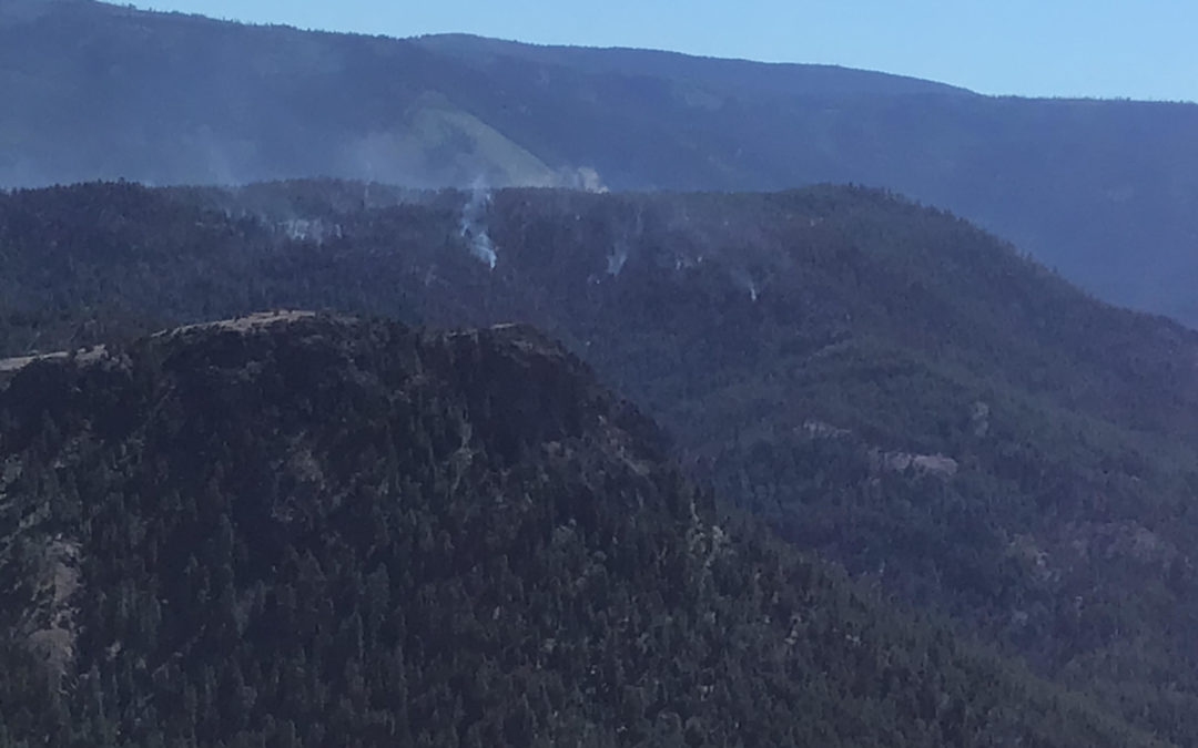
Mitchell, ORE. – Mop-up is in full swing on the Lewis Rock Fire five miles south of Mitchell. The size of the fire has not changed in three days, holding at 440 acres. Containment has reached 30 percent.
Part of the mop-up process includes a two-person crew armed with hand-held infrared cameras to detect hot spots undetectable to the human eye. These patches of heat can smolder beneath the surface of bulldozer berms, stumps, rocks and downed logs. Once detected, the area is unearthed with hand tools and soaked much like drowning a campfire.
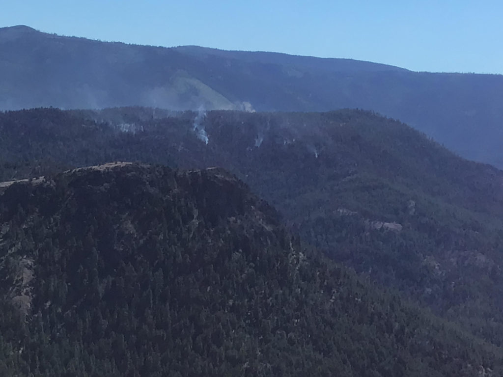
Aerial shot from the Lewis Rock Fire.
Extreme fire weather consisting of elevated temperatures, low humidity and gusty winds will continue throughout the week maintaining the potential threat of flare-ups within control lines.
Fire prevention remains a top priority across the region. Fire officials would like to remind the public to follow fire season restrictions and pay particular attention to any spark emitting activities such as campfires, small equipment use and off-road driving.
Current fire restrictions and information for ODF’s Central Oregon District is available at www.odfcentraloregon.com.
July 7, 2021
La Grande, ORE. — Fire managers are increasing the public use restrictions, also referred to as Regulated Use Closure, on lands protected by Oregon Department of Forestry in northeast Oregon. The measurements that fire managers use to estimate seasonal fire severity are indicating extreme fire conditions across the region.
Effective at 12:01 a.m. July 9, 2021, the Oregon Department of Forestry (ODF) has added additional restrictions to the Public Use Restrictions for lands within the Northeast Oregon District. The Regulated Use Closure affects private, state, county, municipal, and tribal lands in seven counties: Union, Baker, Wallowa, Umatilla and small portions of Malheur, Grant, and Morrow Counties. These Public Use Restrictions are intended to prevent or minimize human-caused wildfires and to protect natural resources and public health and safety.
“This year has been unique in the sense that we are seeing large fires around the region several weeks ahead of when we would normally expect them. With the thunderstorms that have been hitting the area, we must consider our options in reducing the number of preventable fires.” said Steve Meyer, Baker Wildland Fire Supervisor.
The Public Use Restrictions (Regulated Use Closure) include the following fire prevention measures:
- Open fires are prohibited, including campfires, charcoal fires, cooking fires and warming fires. Portable cooking stoves using liquefied or bottled fuels are allowed. Propane fire pits are not allowed.
- Debris burning is prohibited, including the use of burn barrels.
- Non-industrial chainsaw use is prohibited.
- Smoking is prohibited while traveling, except in vehicles on improved roads, in boats on the water, or at a cleared area free of flammable vegetation.
- Use of motor vehicles, including motorcycles and all-terrain vehicles (ATVs), is prohibited except on improved roads, except in the commercial culture and harvest of agricultural crops.
- Possession of the following firefighting equipment is required while traveling, except on state highways, county roads, and driveways: one shovel and one gallon of water or one 2 ½ pound fire extinguisher.
- Cutting, grinding, and welding of metal is prohibited.
- Mowing of dried and cured grass with power driven equipment is prohibited.
- Use of fireworks is prohibited.
- Use of exploding targets is prohibited, as is the use of tracer ammunition or any bullet with a pyrotechnic charge in its base.
- Any electric fence controller in use shall be: 1) Listed by a nationally recognized testing laboratory or be certified by the Department of Consumer Business Services; and 2) Operated in compliance with manufacturer’s instructions.
The Umatilla and Wallowa-Whitman National Forests, as well as the BLM are currently under public use restrictions. Current fire restrictions for forestlands in Northeast Oregon can be found at www.bmidc.org. The Northeast Oregon Fire Prevention line is (541) 975-3027. http://bluemountainfireinfo.blogspot.com/ is your spot for current fire information in the Blue Mountains.
Find us on Facebook at: https://www.facebook.com/oregondeptofforestryNEO/
To report a fire, call Blue Mountain Interagency Dispatch at (541)963-7171 or dial 9-1-1.
July 7, 2021
Mitchell, ORE. – The Lewis Rock Fire held for the second consecutive day and remains at 440 acres. Containment has reached 15 percent. Crews were assisted by a rotation of several helicopters cooling hot spots near containment lines. Today, firefighters will continue to strengthen lines around the fire’s perimeter and to mop-up towards the interior to extinguish hot spots and prevent spot fires.
Weather conditions remain a concern with high temperatures, low relative humidity, and gusty winds. Poor humidity recovery overnight could promote more active fire behavior. The approach of a cold, dry front this afternoon could potentially further challenge the firefighting effort due to shifting winds.
Safety remains our top priority. This includes trying to prevent COVID-19 infections by taking proactive measures to ensure the safety of fire personnel and maintaining best practices not only this fire season but into the future.
The fire team would like to extend its thanks and appreciation for the support from the Mitchell Community during the suppression effort.
The active early fire season under extreme fire danger conditions gives fire officials cause to spread the fire prevention message. Preventable human-caused fires have the potential of pulling much needed resources away from fires sparked by lightning. The public is required to follow fire season restrictions such as campfires, small equipment use and off-road driving.
Current fire restrictions and information for ODF’s Central Oregon District is available at www.odfcentraloregon.com
Inciweb: https://inciweb.nwcg.gov/incident/7604/
| Fire Size: |
440 acres |
| Start Date: |
June 30, 2021 |
| Location: |
5 miles south of Mitchell, OR |
| Cause: |
Lightning |
| Personnel: |
405 |
| Assigned Resources |
|
| Hand Crews: |
17 |
| Engines: |
10 |
| Dozers: |
5 |
| Water Tenders: |
5 |
| Other Heavy Equipment: |
4 |
| Helicopters: |
6 |
| Injuries: |
0 |
| Structures Threatened: |
0 |
| Structures Damaged: |
0 |
| Structures Destroyed: |
0 |
| Evacuations: |
None |
July 6, 2021
National: Preparedness Level 4 (Three or more geographic areas have large, complex wildfires that require IMTs)
| |
# of fires |
Acres burned |
| Total to date |
32,114 |
1,583,418 |
Oregon: Preparedness Level 3 (Fire activity in two or more geographic regions is requiring a major commitment of national resources)
| Only ODF-protected lands (16 million acres) |
| |
# of fires |
Acres burned |
| 2021 year-to-date |
503 |
8,570 |
| 10-year avg. year-to-date
(2010 – 2020) |
287 |
2,267 |
| All lands in Oregon (Includes ODF-protected lands) |
| |
# of fires |
Acres burned |
| 2021 year-to-date |
831 |
36,231 |
Current large fires in Oregon: Includes all lands
| Name |
Date |
Acres |
Containment |
Location |
Cause |
Notes |
| Lewis Rock |
June 30 |
440 |
0% |
4.5 mi S of Mitchell |
Lightning |
ODF Team 3 assumed command July 5. More info |
| Jack |
July 5 |
500 |
0% |
20 mi E of Glide |
Unknown |
NW Team 9 will in brief today at 6 p.m. More info |
| Dixie Creek |
July 3 |
541 |
50% |
3 mi NW of Prairie City |
Lightning |
On lands protected by ODF and Prairie City RFD. |
| Rattlesnake |
June 30 |
5,479 |
65% |
12 mi NE of Warm Springs |
Unknown |
Structures threatened. Road, trail and area closures. More info |
| Black Mountain |
July 1 |
150 |
50% |
10 mi SE of Mitchell |
Lightning |
Last report. |
More information:
July 6, 2021
Mitchell, ORE. – Oregon Department of Forestry’s Incident Management Team 3, led by Incident Commander Tyler McCarty, assumed command of the Lewis Rock Fire Monday evening. The arrival of the team brings in additional overhead capacity and firefighting resources. The team’s presence also relieves local assets that have been battling the fire since June 30.
Persistent winds that have been challenging firefighters over the past several days finally calmed and allowed crews to hold the fire in check overnight. The fire is now estimated at about 440 acres. While an overnight infrared flight detected heat close to containment lines, firefighters have established hose lays along much of the fire’s perimeter and are beginning to mop-up towards the interior to prevent spot fires.
Crews are also working against the clock as thunderstorms are expected to develop over the area this afternoon bringing the threat of lightning and erratic winds. Some crews will be at-the-ready should additional fires spark from the predicted lightning.
The active early fire season under extreme fire danger conditions gives fire officials cause to spread the fire prevention message. Preventable human-caused fires have the potential of pulling much needed resources away from fires sparked by lightning. The public is required to follow fire season restrictions such as campfires, small equipment use and off-road driving.
Current fire restrictions and information for ODF’s Central Oregon District is available at www.odfcentraloregon.com
Inciweb: https://inciweb.nwcg.gov/incident/7604/
| Fire Size: |
440 acres |
| Start Date: |
June 30, 2021 |
| Location: |
5 miles south of Mitchell, OR |
| Cause: |
Lightning |
| Personnel: |
302 |
| Assigned Resources |
|
| Hand Crews: |
14 |
| Engines: |
10 |
| Dozers: |
5 |
| Water Tenders: |
5 |
| Other Heavy Equipment: |
4 |
| Helicopters: |
3 |
| Injuries: |
0 |
| Structures Threatened: |
0 |
| Structures Damaged: |
0 |
| Structures Destroyed: |
0 |
| Evacuations: |
None |
July 5, 2021
John Day, Ore. – The Lewis Rock Fire has grown to an estimated 400 acres, since being sparked by lightning June 30th. Firefighters have continued to be challenged by numerous spotfires outside containment lines, caused by flying embers from trees torching. Wildland fuel conditions are incredibly dry and receptive to these sparks, causing these spotfires to rapidly spread.
Most of the fire movement has been to the south, away from Mitchell and the surrounding community. Today, dozers were used directly against the northern flank of the fire, with hotshot crews working in tandem to strengthen the line. The Wheeler County Sheriff and fire managers are confident there is no threat to the Mitchell area at this time.
At 12:00 p.m. today the Central Oregon District in-briefed Oregon Department of Forestry’s Incident Management Team 3, Incident Commander Tyler McCarty. The team will be taking command of the fire today at 6:00 p.m.
During in-briefing for the team, Rick Shaffer, Wheeler County Commissioner said “I’ve lived in Wheeler County for 72 years and I have never seen conditions like this. You think you’ve caught the fire and then you hear on the radio that there are spots across the line. It’s just really dry out there.”
Safety concerns for firefighters highlighted during in-briefing were heat related illnesses as temperatures are forecast to return to around 100 degrees in the coming days. There have been no accidents or injuries on the fire.
ODF Central Oregon District
Public Information: 541-263-0661
www.facebook.com/ODFCentralOregon
Twitter: @ODF_COD
Current fire restriction information and information for the Central Oregon District is available at www.odfcentraloregon.com.
Contact: Tom Fields
LewisRock.Information@gmail.com
July 5, 2021
John Day, Ore. – The Dixie Creek Fire, burning approximately three miles northwest of Prairie City, has burned approximately 570 acres of grass, brush, and timber within Oregon Department of Forestry’s (ODF) Central Oregon District and Prairie City Rural Fire Department protection. Today at 6:00 a.m. command of the fire transferred to the High Desert Interagency Type 3 Team, led by incident commander Tim Boyce.
The fire was initially reported Saturday afternoon, rapidly spreading. Air and ground resources were able to stop the fire late in the evening, and have kept the fire within the same footprint since the initial burn period. Overnight Sunday fire personnel patrolled the fire, monitoring for any change to fire behavior or areas of concern. The fire is 25% contained.
Today firefighters will focus on mopping up along the edge of the fireline to secure the perimeter. Tankers and helicopters are available to support on the ground suppression activities. Resources assigned to the fire include hotshot crews, dozers, watercats, skidgines, hand crews, wildland fire engines, water tenders, and numerous overhead to manage the incident.
The High Desert Interagency Type 3 Team is comprised of personnel from the Malheur National Forest, and Vale and Burns District Bureau of Land Management.
ODF Central Oregon District
Public Information: 541-263-0661
www.facebook.com/ODFCentralOregon
Twitter: @ODF_COD
Current fire restriction information and information for the Central Oregon District is available at www.odfcentraloregon.com.
July 5, 2021
Central Oregon – With minimal new fire activity, firefighters have been able to achieve containment on several fires around Central Oregon.
The Wrentham Market Fire is now 100% contained at 7,222 acres east of Dufur in Wasco County.
The Rattlesnake Fire is now 90% contained at 5,479 acres burning on Prineville District BLM managed lands in the area of South Junction campground and the Warm Springs Reservation. For more information on this fire, visit: https://inciweb.nwcg.gov/incident/7592/
The 1,102 acre Ryegrass Fire east of the Maury Mountains and south of the Paulina Highway on Prineville District BLM lands is now 100% contained.
The Dry Creek Fire (incident 449) is burning south of the historic Rager Ranger Station on the Prineville District BLM now 100% contained at 53 acres.
The Sulphur Spring Fire (incident 447) by Maupin Butte east of the Maury Mountains on Prineville District BLM lands and south of Paulina Highway is 81 acres and 70% contained. Crews are continuing mop up today.
The Black Mountain Fire (incident 475) is in the area of Deep Creek on the Ochoco National Forest, 6-7 miles east of Big Summit Prairie is now 50% contained. Crews are continuing to hold and secure the 150 acre fire and have two crews, an engine, and a water tender assigned to the incident.
Incident 500 near Barnhouse Campground on the Ochoco National Forest was contained at 1 acre yesterday.
Firefighters did assist city and county resources with several small fires related to 4th of July firework displays. All were contained last night.
This will be the final daily COIDC fire update until fire activity increases.
For up-to-date information on Central Oregon fires, visit www.centraloregonfire.org or www.twitter.com/CentralORFire
July 4, 2021
Two new fires were reported on lands protected by Oregon Department of Forestry’s (ODF) John Day Unit on Saturday. The Mitchell Spring Fire was reported mid-morning approximately eight miles east of Spray and was fully contained and controlled at less than a tenth of an acre by early afternoon. The Dixie Creek Fire, burning two miles northwest of Prairie City, was reported late in the afternoon on ODF and Prairie City Rural Fire Department protection.
Late Saturday evening the fire was estimated to be 570 acres. Overnight firefighters were able to establish dozer line around much of the fire and “wet line” areas of flashy, light fuels. This morning nine engines, two water tenders, two Malhuer National Forest crews, one contract crew, La Grande Interagency Hotshots, seven dozers, and two skidgines are working to strengthen the fireline. Additional resources arriving today include two contract engines, a skidgine, three hand crews, and three hotshot crews. Air resources such as helicopters and air tankers are available to support firefighter efforts on the ground.
There is no threat to structures or residences from the fire. ODF continues to work with the Grant County Sheriff to monitor any changes in fire behavior or direction which could impact homes near the fire.
High Desert Type 3 Team, comprised of personnel from the Malheur National Forest and Vale and Burns Districts Bureau of Land Management, will be integrating with fire management today planning for transitioning fire management Monday morning.
Increased evening wind, pushing from the north, caused spotfires outside the line on the Lewis Rock Fire near Mitchell. Dozers were used throughout the night to complete fireline around the new fire growth. Today hand crews, engines and dozers will continue work securing the perimeter. Aircraft is available to support fire suppression activity. The fire burned away from Mitchell and the surrounding community.
The Bologna Fire, burning on private ownership and Prineville District Bureau of Land Management lands near Spray is 75% contained. Today the fire will have one crew and one engine assigned to the fire. They will be working to find any hot spots within the perimeter and monitoring the fire.
Regulated-Use Closure is in effect for the Central Oregon District. Fireworks and campfires (including cooking fires) are not allowed within the district boundary. For additional information on ODF’s Central Oregon District, including contact information and unit offices, please visit www.ODFcentraloregon.com.
July 3, 2021
ASHLAND, Ore. – A vehicle fire and subsequent grassfire prompted a multi-agency response to the 11000-block of Dead Indian Memorial Road outside of Ashland on Saturday, July 3, 2021. The vehicle fire was quickly extinguished by Jackson County Fire District 5 (JCFD5). Through an aggressive initial attack from the air and on the ground, the grassfire portion of the incident is 100% lined and 50% mopped up at the time of this release. It was stopped at 1.5 acres.
The Dead Indian Memorial Road Fire was first reported at approximately 3:30 p.m. as a vehicle fire. When first responders arrived on scene, it had spread to the wildland and was being carried uphill by the wind. ODF Southwest Oregon District responded alongside our partners at JCFD5 with multiple engines, a bulldozer, a water tender, our type 2 helicopter, our helitack type 3 helicopter, and our air attack plane. Our partners at Ashland Fire Rescue, Greensprings Rural Fire Department, Bureau of Land Management (BLM), and Jackson County Sheriff’s Office responded as well, and Medford Fire-Rescue moved up to cover for JCFD5. Within the first hour of initial attack, the forward spread of the grass fire was stopped.
ODF investigators have confirmed the grassfire portion of the incident was caused by the vehicle fire; the vehicle fire will be investigated by JCFD5. Smoke may be seen in the area as crews continue to mop up into the evening. They will remain on scene until the fire is extinguished and it is safe to leave the area.
This incident is an example of how quickly a fire can take off; the extremely dry fuels paired with hot weather our region has been experiencing are prime conditions for fires to start and spread rapidly. ODF is asking the public to keep this in mind during holiday weekend celebrations. One less spark can mean one less wildfire.
Online: www.swofire.com | Facebook: @ODFSouthwest | Twitter: @swofire
July 3, 2021
Firefighters continue to make progress on fires in Oregon Department of Forestry’s John Day Unit. The Lewis Rock Fire and Bologna Fire were sparked by passing thunderstorms Wednesday. Additional “holdover” fires are anticipated from these storms as fuels dry and temperatures remain warm.
Firefighters completed fireline on the Lewis Rock Fire Friday, and reached 29% containment for the fire. Late in the day three Single Engine Air Tankers (SEATs) and a heavy airtanker were used to knock down a flare up inside the fire perimeter. Firefighters began plumbing fire hose around the fire to distribute water for mop-up activities. The fire is estimated to be 70 acres.
The evacuation level for residences near the fire on Dollarhide Road have been reduced to Level 1. The town of Mitchell and surrounding community remain on a level 1 evacuation notice. For further information and current evacuation status visit the Wheeler County Sheriff’s facebook page: https://www.facebook.com/WheelerCountySheriffsOffice.
Friday firefighters completed fireline around 70% of the Bologna Fire. The fire has burned approximately 140 acres of grass and juniper near Spray. Helicopters were used Friday to control spotfires outside the fire caused by rolling fire debris. Today five crews will be assigned to the fire.
Regulated-Use Closure is in effect for the Central Oregon District. Fireworks and campfires (including cooking fires) are not allowed within the district boundary.
For additional information on ODF’s Central Oregon District, including contact information and unit offices, please visit www.ODFcentraloregon.com.
July 2, 2021
Central Oregon Interagency Dispatch Update – July 2, a.m.
Central Oregon – Crews will spend the day constructing and securing containment lines on numerous active fires in Central Oregon.
The largest fire in the area remains the Wrentham Market Fire currently estimated at 10,000 acres east of Dufur in Wasco County. It is now 38% contained. For more information on this fire, visit: https://inciweb.nwcg.gov/incident/7589/
The Rattlesnake Fire is estimated at 5,433 acres with 10% containment burning on Prineville District BLM managed lands in the area of South Junction campground and the Warm Springs Reservation. For more information on this fire, visit: https://inciweb.nwcg.gov/incident/7592/
The Ryegrass Fire is holding at approximately 1,000 acres east of the Maury Mountains and south of the Paulina Highway on Prineville District BLM lands. Crews have put in a preliminary line around the fire and will continue to hold and improve that line to achieve containment.
There was little growth on the Dry Creek Fire (incident 449) burning south of the historic Rager Ranger Station on the Prineville District BLM remains 50 acres. Fire lines held through the night and the 20 person hand crew and 10 smokejumpers assigned to the incident will continue to secure lines today.
The Sulphur Spring Fire (incident 447) by Maupin Butte east of the Maury Mountains and south of Paulina Highway is 81 acres and burning on Prineville District BLM lands. Several smokejumpers and a 10 person hand crew are continuing line construction and will use a helicopter to cool hot spots from interior burning.
The Crystal Creek Fire (incident 453) is holding at approximately 3 acres, burning in heavy timber east of Mark’s Creek subdivision on the Ochoco National Forest. All containment lines held over night and crews will continue to cool pockets of heat on the interior of the fire.
The Black Mountain Fire (incident 475) is in the area of Deep Creek on the Ochoco National Forest, 6-7 miles east of Big Summit Prairie. 3 hotshot crews will be working the 100 acre blaze today, constructing containment lines around the rugged scab flats in the fire area.
The Bologna Fire (incident 165 dispatched out of John Day) approximately 7.5 miles east of Spray, is estimated to be 140 acres with 0% containment. It is burning on approximately 25 acres of Prineville District BLM managed land with the remainder of the fire under the protection of the Oregon Department of Forestry (ODF). Two engines, heavy air tankers, a VLAT (very large air tanker), two Type 2 helicopters, two 5 person crews from ODF, and one engine are attacking the fire burning in grass and brush. Three structures are threatened by this fire.
With a return to hot and dry conditions over the holiday weekend, fire officials anticipate more fire starts to pop up in the next two weeks. The public is reminded that we remain in EXTREME fire danger and public use restrictions are in place on all federally managed public lands.
For up-to-date information on Central Oregon fires, visit www.centraloregonfire.org or www.twitter.com/CentralORFire
July 1, 2021
Prineville, Ore. – Passing thunderstorms Wednesday afternoon and evening sparked several new fires on Oregon Department of Forestry protected lands within the Central Oregon District. Some of the storm cells came with significant precipitation, but in other areas there was limited moisture. Today firefighters will work to locate fires from the storm as well as continuing suppression efforts on existing fires. Reconnaissance flights are already in the air looking for new fires.
Today will be slightly cooler than the last few days, but temperatures are expected to be in the mid-90’s across the area with moderate winds. The warm temperature and wind is likely to fan any smoldering embers in already dry wildland fuels. Additional thunderstorms are likely on the eastern edge of the District which may impact fire behavior and start additional fires. In an effort to reduce active fires on the landscape ODF firefighters are working closely with rural fire departments and federal partners in suppression action. Wildfires impact air and water quality for communities across the region.
The Lewis Rock Fire, located two miles south of Mitchell in the John Day Unit, challenged firefighters late Wednesday evening. Erratic winds from passing thunderstorms did not allow for retardant drops from large air tankers, however overnight bulldozers were able to complete fireline around 95% of the fire. Remaining fireline will be constructed today by contract hand crews. Seven engines and two tenders will be working to provide water to secure the fire perimeter. The fire is 58 acres and 0% contained. Four air tankers are being used today to keep the fire inside last night’s dozer line. Residences in the Dollarhide area were placed on a Level 2-Be set evacuation notice by the Wheeler County Sheriff late Wednesday night. As a precaution, in anticipation of this afternoon’s thunderstorms, the town of Mitchell and surrounding community will be placed on a Level 1-Be Ready evacuation notice. For current evacuation information visit https://www.facebook.com/WheelerCountySheriffsOffice.
Two additional fires in the John Day Unit were limited to a single tree. The Prineville Unit caught one fire at less than a 1/10 of an acre and spent much of Wednesday evening working to locate reported fires or assisting cooperators.
For additional information on ODF’s Central Oregon District, including contact information and unit offices, please visit www.ODFcentraloregon.com.
July 1, 2021
SALEM, Ore. – Fire potential remains high through the 4th of July weekend. The continued drought, recent heatwave, and forecasted hot temperatures means there is more need for caution.
Oregon’s State Fire Marshal (OSFM) Mariana Ruiz-Temple and the Oregon Department of Forestry (ODF) Chief of Fire Protection Doug Grafe ask people to be mindful of these conditions when celebrating the holiday. Before lighting off fireworks, they encourage people to know when and where it is allowed.
“The continued drought, coupled with the current weather means everything including forests are extremely dry,” Grafe said. “It’s been a tough year. We have a lot to celebrate this 4th of July. While we do that, I ask you to help prevent fires, which helps protect our forests, communities, and firefighters.”
This year, some Oregon cities and counties put restrictions in place on the use of fireworks through the weekend. If using legal fireworks in communities where they’re allowed, always have a bucket of water on hand to drown spent or used fireworks, have a charged hose nearby, and never light fireworks near dry grass or areas that could catch fire easily.
“Please check with your local municipality, fire service agency, or county on the local laws where you will celebrate the holiday,” Ruiz-Temple said. “Safety of those in Oregon is not only a priority for those who live, work and visit, but for our firefighters as well. We ask that you follow all restrictions and help us in being safe and responsible this holiday weekend.”
In Oregon, it’s illegal to possess, use, or sell fireworks that fly into the air, explode, or travel more than 12 feet horizontally on the ground without a permit. The OSFM can issue permits. Bottle rockets, Roman candles, and firecrackers are illegal without a permit. Officials may seize illegal fireworks and charge offenders with a class B misdemeanor with a fine of $2,500 per firework. A person misusing or causing damage using fireworks can be required to pay firefighting costs and for other damage. Parents are liable for fireworks damage caused by their children.
During fire season it is illegal to use fireworks on ODF-protected lands. While enjoying the forests or outdoors here are ways you can help prevent fires:
- Skip the campfire – it’s already hot enough
- Use a camp stove for cooking
- Don’t use fireworks – enjoy a community’s firework display instead
- Stay on the roads – heat from vehicles can easily start grass on fire
- Don’t smoke – if you do, put the butts out and dispose of them properly
- Don’t use anything with open flame or that could cause sparks
- Check trailer chains to ensure they don’t drag along the road
Here are some resources to help keep Oregon’s forests and communities safer this 4th of July. ODF’s current public fire restrictions map and OSFM Fireworks FAQ
July 1, 2021
Joint news release from South Central Oregon Fire Management Partnership:
Oregon Department of Forestry
www.oregon.gov/odf
BLM Lakeview District
www.blm.gov/office/lakeview-district-office
Fremont-Winema National Forest
www.fs.usda.gov/fremont-winema
Sheldon-Hart Mountain & Klamath Basin National Wildlife Refuge Complexes
www.fws.gov/refuge/Hart_Mountain
www.facebook.com/KlamathBasinRefuges/
LAKEVIEW, Ore. – Following a severely hot and dry week, the raising of Fire Danger to Extreme and an early start to Public Use Restrictions for the agencies of the South Central Oregon Fire Management Partnership (SCOFMP), it is critical that area residents and visitors take actions to prevent wildfires.
“Human-caused wildfires are entirely preventable,” said Randall Baley, Protection Unit Forester for Oregon Department of Forestry (ODF). “With the current conditions, it is extremely important that people are vigilant with anything that can spark a wildfire, call 911 as soon as a wildfire starts, and have the recommended items on hand for initial firefighting, including at least a gallon of water or a 2 ½ pound or larger fire extinguisher, a shovel and an axe.”
The current fuel conditions in the SCOFMP area in Klamath and Lake counties are closer to August than early July, with extremely dry fuels that can carry wildfire rapidly.
The July 4 holiday weekend is popular for outdoor recreation, including camping, barbecues and family celebrations. While there are fireworks being sold locally, fireworks are not allowed on federal lands and are currently not allowed on ODF protected private, county and state wildlands.
“Fuel conditions right now are so dry that even sparklers or poppers could ignite a large wildfire,” said Baley. “If you choose to use fireworks this July 4, please restrict it to areas where it is permitted and take appropriate safety measures. For those living in the wildland urban interface, on forested lands, or who are recreating on public lands, these are not places for firework use, especially this year.”
Fireworks can cause costly and dangerous wildfires, especially when conditions are hot and dry, and vegetation is receptive to sparks. Fires caused by fireworks on public lands may result in the user being cited and billed for the cost of fire suppression.
Summer holiday weekends, including the Fourth of July, typically see an increase in abandoned campfires on public lands.
“Public Use Restrictions are currently in effect on public lands, which means campfires are restricted to designated areas as identified in the individual orders for each agency,” said Interagency Fire Management Officer Jeb Koons. “If you are in an area that allows campfires, never leave it unattended and make sure that it is dead out and cold to the touch before leaving.”
The public is responsible for ensuring that they have reviewed and are aware of the restrictions in place for the landscape they plan to recreate or work on. For all agencies, violation of these prohibitions could result in citations, fines, and even imprisonment, depending on the agency and order.
For more information on the ODF Public Regulated Use Closure, please visit https://www.oregon.gov/odf/fire/pages/restrictions.aspx. For more information on the federal agency Public Use Restrictions and Fire Prevention Orders, please visit https://scofmp.org/restrictions.shtml.
To help prevent wildfires, it’s advised to do the following:
- Before going camping, check fire restrictions in place and never leave a campfire unattended. Build campfires in cleared open areas and keep water and a shovel nearby. Make sure campfires are out and cool to the touch before leaving the area.
- Consider alternatives to a campfire, such as a portable camp stove.
- If using charcoal, make sure to drown and stir them, repeating until they are cold to the touch.
- Smoking should only be in a closed vehicle or fire-safe area and always dispose of cigarette debris in some type of an ashtray. Check local Use Regulations for specific rules.
- Avoid driving and parking in tall grass or on roads with heavy, fine fuel accumulations. Exhaust particles, hot exhaust pipes and hot catalytic converters can start grass fires in a matter of seconds. Also, maintain proper tire pressure – driving on exposed wheel rims can throw sparks.
- Secure chains properly from trailers or other equipment. Sparks from dragging chains, and exhaust from ATVs and motorcycles, can start grass fires. Spark arresters are required on all recreational and portable gasoline-powered equipment.
- Carry firefighting equipment in vehicles, including a shovel, at least one gallon of water or one 2 ½ pound or larger fire extinguisher.
“We have already seen a number of large fires this season, with several in Klamath County requiring evacuations since late March,” said Baley. “Helping to prevent wildfires by being safe, responsible and staying vigilant will avoid the need for evacuations of residences, recreation facilities and campgrounds, and let everyone – including our area wildland firefighters – have an enjoyable holiday weekend.”
An additional challenge for SCOFMP agencies in Klamath and Lake counties this week is lightning in the forecast and recent Red Flag Warnings for dry conditions and abundant lightning on dry fuels.
“The SCOFMP agencies have exceptional wildland firefighters prepared to respond to fires from the incoming lightning,” said Koons. “That preparedness is improved by reducing the human-caused fires they need to respond to.”
Fire managers appreciate the assistance and cooperation from area residents and visitors to prevent wildfires through the holiday weekend and as the summer continues.
“We’ve already seen an active start to fire season and fuels conditions continuing to be six weeks or more ahead of the average,” said Koons. “Our area residents and visitors are important partners in helping us prevent large and destructive wildfires throughout this summer. We want everyone to have a safe, healthy and happy Fourth of July holiday and that starts with preventing wildfires!”
South Central Oregon Fire Management Partnership provides comprehensive wildland fire services to more than eight million acres of land administered by the Bureau of Land Management Lakeview District; Fremont-Winema National Forest; Oregon Department of Forestry Klamath-Lake District; U.S. Fish and Wildlife Service’s Klamath Basin and Sheldon-Hart Mountain National Wildlife Refuge Complexes; and Crater Lake National Park. The area encompasses federal, state, and private lands within south central Oregon and northwest Nevada.
July 1, 2021
Landowners with property recently assessed for the first time must now follow regulations.
JACKSON AND JOSEPHINE COUNTIES, Ore. – Properties in Jackson and Josephine Counties that have recently been classified as forestland will begin receiving fire suppression protection from the Oregon Department of Forestry Southwest Oregon district today. Along with this protection service, ODF regulated use fire prevention restrictions also go into effect; the current fire danger level is high (yellow) and the IFPL is two (2). All current regulations are available on the district’s website, www.swofire.com/public-fire-restrictions/.
The Oregon Department of Forestry’s Southwest Oregon District provides wildland fire protection services to forestlands in Jackson and Josephine counties, funded by a Forest Patrol Assessment on protected lands. The Jackson and Josephine County Forestland Classification Committee was formed in 2017 to reassess private land in the counties through a process that was completed earlier this spring. Multiple letters were sent to the landowners of properties that were added in this process notifying them of the change.
Classification changes do not increase ODF’s fire budget, rather, the classification review helps ensure that protection costs are fairly distributed. Those costs are then matched by the state’s general fund. In most cases, a review typically results in some lands being removed from forest classification and others being added. In the Southwest Oregon District, many of the new additions were already receiving fire suppression services, but had not been paying for it.
During the assessment process, the committee examined all lands within Jackson and Josephine counties, classifying them either as “forestland” or “not forestland” according to:
- Fire risk potential
- Vegetation type (fire fuel)
- Community structure
- Proximity to other forestland
The committee’s efforts are helping to resolve issues pertaining to ODF’s fire suppression role on forestlands and adjacent properties, and is the basis for assessing lands for the costs of wildland fire protection.
Landowners with questions about the assessment, regulations or general information can call the ODF office nearest them:
- Medford Unit, 5286 Table Rock Rd., Central Point. (541) 664-3328
- Grants Pass Unit, 5375 Monument Dr., Grants Pass. (541) 474-3152
July 1, 2021
Central Oregon Interagency Dispatch Update – July 1, 12 p.m.
Central Oregon – A lightning storm passed through Central Oregon yesterday and early this morning, blanketing the landscape with hundreds of lightning strikes and localized precipitation. Crews worked through the night on several fires and have picked up 5 new starts this morning.
The largest fire in Central Oregon remains the Wrentham Market Fire currently estimated at 10,000 acres east of Dufur in Wasco County. The Oregon State Fire Marshall Team with assistance from the Central Oregon Fire Management Service fire officials, is responding to the fire burning on unprotected lands in the Columbia Rural Fire Protection District. The Wasco County Sheriff’s Office issued Level 3 evacuation notices yesterday for homes in the area impacting 70-100 people.
The Rattlesnake Fire is now estimated at 4,700 acres with no containment burning on Prineville District BLM managed lands in the area of South Junction campground and the Warm Springs Reservation. The Rattlesnake Fire is now under the unified command of Warm Springs Incident Commander Lionel Smith and Type 3 Central Oregon Fire Management Service (COFMS) Incident Commander Larae Guillory. Four large air tankers, two Single Engine Air Tankers (SEATs), a heavy helicopter, are responding to the blaze in addition to the Central Oregon Rappellers and Redmond Hotshots. Trout Creek Campground on the Deschutes River is currently under a Level 2 (SET) evacuation order from Jefferson County Sheriff’s Office.
The Ryegrass Fire is estimated at 1,000 acres and is east of the Maury Mountains and south of the Paulina Highway on Prineville District BLM lands. A hotshot crew and 3 engines are responding. The fire is 0% contained at this time.
Incident 449 is a 55 acre fire south of the historic Rager Ranger Station on the Ochoco National Forest and is being staffed by 10 smokejumpers.
Incident 447 by Maupin Butte near the Maury Mountains and south of Paulina Highway is 15 acres and burning on Prineville District BLM lands. Several engines are responding and it is 0% contained.
Incident 465, the Rocky Butte Fire, is burning near Steins Pillar on the Ochoco National Forest. It is estimated at 4-5 acres with two engines, a crew and aviation assets supporting suppression efforts. It is 0% contained at this time.
Incident 460 near Pringle Falls Campground on the Deschutes National Forest was contained at under ¼ acre.
With a return to hot and dry conditions over the holiday weekend, fire officials anticipate more fire starts to pop up in the next two weeks. The public is reminded that we remain in EXTREME fire danger and public use restrictions are in place on all federally managed public lands.
For up-to-date information on Central Oregon fires, visit www.centraloregonfire.org or www.twitter.com/CentralORFire
