July 15, 2021
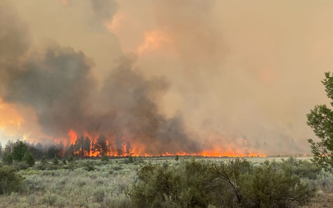
SISTERS, Ore. – Firefighters were challenged by a forecasted west wind that pushed on the east flank of the fire Wednesday afternoon and evening. Despite gusty winds and continued hot and dry conditions, there was minimal growth on the Grandview Fire, which is burning on private lands protected by the Oregon Department of Forestry and the Crooked River National Grassland.
A concerted effort on securing the perimeter has allowed crews to focus on holding and improving containment lines around the majority of the fire. Along with protecting natural resources, fire crews have been focused on point protection. With aggressive firefighting efforts on the ground supported by aerial resources, no structures have been lost on the Grandview Fire.
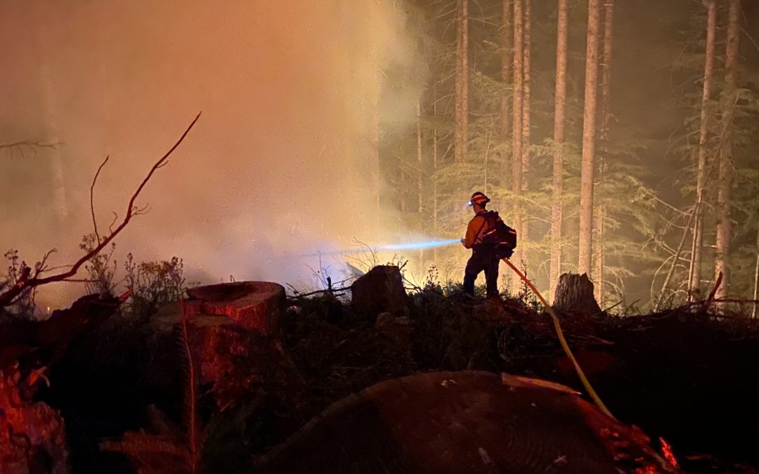
Helicopters assisted crews today by cooling hot spots near the perimeter. Where containment lines have been secured, firefighters have been able to begin mopping up the perimeter to ensure hot spots are extinguished and sparks or hot embers won’t escape containment lines to create spot fires.
A Red Flag Warning has been issued by the National Weather Service and remains in effect through Thursday. Predicted low relative humidity and winds between 10-20 mph (gusts to 25mph) out of the northwest will continue to challenge containment lines on the fire’s eastern and southeastern edges. Crews will continue to build and strengthen containment lines and burnout fuels adjacent to lines when conditions allow.
For up-to-date information on the Grandview Fire, please visit: https://inciweb.nwcg.gov/incident/7651/
There are evacuation notices in place issued by the Jefferson County Sheriff’s Office and Deschutes County Sheriff’s Office. Those can be found here: https://arcg.is/5P4LS
July 14, 2021
FOREST GROVE, Ore. – Firefighters made good progress today on the Game Hog Creek Fire burning 22 miles northwest of Forest Grove on the Tillamook State Forest. Although the fire remains uncontained because fire lines are still being built, the fire’s spread was largely stopped at about 70 acres. A helicopter kept the fire in check through the afternoon as temperatures rose. Steep portions where the fire is burning remain inaccessible to hand crews.
The night shift will continue to strengthen fire lines tonight. Smoke is expected in the area overnight but little fire growth. Tomorrow, firefighters will continue building containment lines and if all goes well start mopping up, cooling hot spots within the fire’s interior.
Firefighters from six Oregon Department of Forestry offices worked on the fire along with crews from South Fork. Hampton Lumber and Stimson Lumber Company provided water tender support.
Highway 6 and 26 to the coast remain open and unaffected by the fire, which is entirely within the state forest. Drift Creek and Idiot Creek forest roads are closed as is the Fear and Loaming mountain bike trail due to fire activity in the area. Rogers Camp trailhead is being used as a staging area for firefighters and is closed to the public. Elk Creek campground is open.
The fire was originally sparked on July 3 and contained then to six acres in a steep, inaccessible area. Rising winds Tuesday night apparently caused the fire to jump the control lines. Cause of the fire is still under investigation.
# # #
July 14, 2021
Community Meeting: Please join us for a virtual community meeting July 14, 2021 at 6:30 p.m. at www.facebook.com/BootlegFireInfo.
Fire Information Public Phone: 541-482-1331
Fire Information Media Phone: 971-727-7255
JIC Email: scofmpjic@gmail.com
Inciweb: https://inciweb.nwcg.gov/incident/7609/
Facebook: https://www.facebook.com/BootlegFireInfo
Evacuation: https://tinyurl.com/bootlegevac
| Estimated Size: |
212,377 acres |
| Containment: |
0% |
| Start Date/Time: |
07/06/2021 |
| Location: |
28 miles northeast of Klamath Falls, OR |
| Cause: |
Under investigation |
| Personnel: |
1,338 |
Klamath Falls, ORE. – Dry and windy conditions contributed to another day of active fire behavior on the Bootleg Fire burning in Southern Oregon. Firefighters reported growth primarily to the east in the greater Gearhart Wilderness area. Air operations were severely limited due to unsafe flying conditions in heavy smoke.
“We’re making steady progress where winds and terrain allow,” said Rob Allen, Incident Commander for PNW2 Incident Management Team. “But for the third day in a row, firefighters had to disengage at times for their safety and weather isn’t going to change for the foreseeable future.”
On the ground, firefighters improved existing dozer and hand containment lines in the Fuego Mountain area. Crews took advantage of favorable conditions overnight to ‘burnout’ along these lines, significantly diminishing the potential for future fire growth toward the east in future weeks and leaving a solid containment line for the community of Chiloquin and Highway 97 in the area.
To the south and east, crews took advantage of yesterday’s inversion to make continued progress on improving dozer and other containment lines. Crews conducted ‘burnout’ operations overnight to strengthen those lines and increase containment. While the fire did not make expansive ‘runs’ as it did in past days, west winds continued to push fire growth toward the greater Snake and Round Butte areas under Red Flag conditions.
Evacuations: Evacuations are rapidly changing due to the nature of this wildfire. Please visit tinyurl.com/bootlegevac for an interactive map of evacuation level in Lake and Klamath Counties.
Closures: The Fremont-Winema National Forest is closed to the public in the fire area. Map and full order available at inciweb.nwcg.gov/incident/7609/.
Smoke: Heavy smoke expected July 14, 2021 with widespread impacts to communities and State Route 140 in Oregon between Chiloquin and Bly. Full report at: fires.airfire.org/outlooks/southcentraloregon.
Hashtags: #BootlegFire #FireYear2021
July 14, 2021
Email: 2021.jack@firenet.gov
Phone: 541-201-2335
Hours: 8 a.m. – 6 p.m.
InciWeb: https://inciweb.nwcg.gov/incident/7605
Facebook: https://fb.me/JackFire2021
Northwest Incident Management Team 9 (IC Brian Goff)
SIZE: 13,907 acres
CONTAINMENT: 15%
PERSONNEL: 781
CAUSE: Under Investigation
Location: East of Glide, OR in the Umpqua National Forest
Fire information: The Jack Fire is currently estimated at 13,907 acres and is 15% contained. Cooler temperatures and higher relative humidity the next few days will help resources hold the fire within the planned containment line. North of HWY 138, Crews will continue to hold, secure and mop-up along the 4760 Road moving east towards Dog Mountain. Firefighters will burn vegetation away from containment lines in the northeastern corner of the fire perimeter as needed to hold the fire within the planned containment area. In the Dry Creek area, crews continue mop-up around the structures.
South of HWY 138, on the western perimeter of the incident, the fire continues to move south along the 4714 road. Crews will continue to hold the fire east of the road, burning out vegetation as needed to strengthen the line. Crews are utilizing trails, roads, and hand lines to hold the fire within the planned containment lines on the southern-most edge of the fire. Today, firefighters will hold established containment lines while preparing lines to the south.
Structures: Structures have been prepped, structure protection enhanced and will be monitored by NW Team 9 and the Douglas Forest Protective Association.
Aviation: Four Type 1 aircraft and two Type 3 aircraft continue to support firefighters on the ground. Type 1 aircraft include Sikorsky and Kaman 1200 (KMax) helicopters along with a Type 3 A-Star helicopter. Air assets provide ground resources with water and retardant drops to limit the spread of the fire and to help establish and hold containment lines.
Evacuations: All Forest Service campgrounds (Apple Creek, Horseshoe Bend and Eagle Rock) are on Level 3 evacuation GO order. The Dry Creek community as well as all residences on the Illahee Road are also in Level 3 evacuation GO order. Level 2 SET evacuations were issued from mile marker 38 to 43. This includes Steamboat Inn and residences located on Brindle Bug Road, Steelhead Caddis Road, and residences and businesses located between mile post 51 and 55 on Highway 138E. Please visit the Douglas County Sheriff’s Office interactive evacuation map: www.dcso.com/evacuations
Closures: State highway 138E from Steamboat Creek to mile post 55 is closed to vehicle traffic. Steamboat Inn is also closed. Oregon Department of Transportation has set an eastside ‘soft closure’ checkpoint at Lemolo Lake junction to allow for local access into nearby recreation areas, including Lemolo Lake. Please visit https://tripcheck.com/ for updates on road closures. The Umpqua National Forest has issued UPDATED closure orders around the Jack Fire. The full closure order and map can be viewed on Forest website at www.fs.usda.gov/umpqua and on the Jack Fire Facebook page.
Weather: Cooler temperatures in the 80’s today. Winds will be light from the east northeast in morning, changing west northwest in afternoon, with gusts up to 15 miles per hour.
July 14, 2021
Prineville District Bureau of Land Management
Central Oregon Fire Management Service Type 3 team, Incident Commander Jeff Priest
Contact:
Stacy Lacey
Phone: 541-410-5311
Hours: 7:00 am – 8:00 pm
Size: 588 acres
La Pine, Ore – Firefighters were successful last evening in completing line around the Darlene Fire using dozer lines and existing road system.
“A great success by firefighters once again” La Pine Rural Fire Protection Fire Chief Mike Supkis stated.
The 588-acre fire, based on mapping, will continue to challenge firefighters today with a red flag warning of high winds and low relative humidity forecasted for the fire area from noon today through 11pm tomorrow. Structure protection and the safety of residents in the area is a priority for firefighters and all participating agencies, including all participating rural fire protection districts, as fire weather and fuels are still a concern.
Firefighters today will be scouting for spot fires and strengthening the lines in preparation for the afternoon red flag weather moving in. Air resources will continue to used, if needed, as well as dozers, engines, hand crews and water tenders.
A Type 2 team will in-brief this evening and will take over managing the fire beginning of shift on Thursday.
Please continue to monitor the Deschutes County Sheriff’s Department website for current evacuation information: https://bit.ly/3eeTRx1.
July 14, 2021
A virtual community meeting will take place on Facebook Live at 6:30 p.m. this evening. To access the meeting go to https://fb.me/e/2tGkRTQNl.
Grandview Fire Information: 541-633-7410 (7 a.m. – 9 p.m.)
Email: grandviewfire.information@gmail.com
Facebook: https://www.facebook.com/ODFCentralOregon
Twitter: @CentralORFire
Oregon Department of Forestry IMT 2 Matt Howard, Incident Commander and Oregon State Fire Marshal’s Red Team Ian Yocum, Incident Commander
| Fire Size:
Containment: |
5,971 acres
10% |
| Start Date: |
7/11/21 1:30 p.m. |
| Location: |
9 miles NE of Sisters, OR |
| Cause: |
Unknown |
| Personnel: |
694 |
| Assigned Resources |
|
| Hand Crews: |
22 |
| Engines: |
49 |
| Dozers: |
15 |
| Water Tenders: |
15 |
| Other Heavy Equipment: |
6 |
| Helicopters:
Air Tankers: |
2
0 |
| Structural task forces: |
6 |
| Injuries: |
1 |
| Structures Threatened: |
421 |
| Structures Damaged: |
0 |
| Structures Destroyed: |
0 |
| Evacuations: |
Level 1 (Ready), Level 2
(Set), and Level 3 (GO!) are
in effect.Evacuation Levels
https://www.facebook.com/DeschutesCountySheriff
https://www.facebook.com/JeffersonCountySheriff |
Sisters, ORE. – Firefighters successfully slowed the Grandview Fire, located nine miles northeast of Sisters, with minimal spotting as winds died down. The fire is estimated to be 5,971 acres and 10% contained as firefighters secured lines on the easterly side.
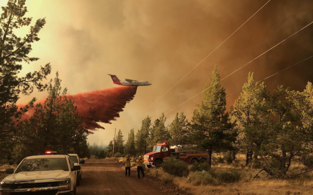
The quick developing Darlene Fire, near La Pine, pulled retardant-dropping air tankers away from the Grandview Fire mid-afternoon, leaving just two helicopters to support crews on the ground. Fortunately, three single engine air tankers (SEATs) were ordered out of Burns, which provided critical support to keep the fire in check where dozer lines ended.
A Red Flag Warning has been issued for today and Thursday. Predicted low relative humidity and winds between 10-20 mph (gusts to 25mph) out of the west will challenge containment lines on the fire’s eastern edge. Crews will continue to build and strengthen containment lines and burnout fuels adjacent to lines when conditions allow.
There are still homes and other structures at risk, but fortunately the fire lines that crews created around the south-eastern perimeter have proven to be very successful. Three structural task forces from the state of Washington arrived last night and will join the seven task forces that were already working to protect homes in the area.
For up-to-date information on the Grandview Fire, please visit: https://inciweb.nwcg.gov/incident/7651/
There are evacuation notices in place issued by the Jefferson County Sheriff’s Office and Deschutes County Sheriff’s Office.
Jurisdictional agencies tied to the fire include Oregon Department of Forestry Central Oregon District and Ochoco National Forest, Crooked River National Grasslands.
July 14, 2021
FOREST GROVE, Ore. – Firefighters from six Oregon Department of Forestry offices are engaged this morning along with crews from South Fork and industrial forest landowners providing water tender support on a wildfire burning in the Tillamook State Forest about 22 miles northwest of Forest Grove. The fire is estimated at about 70 acres.
The Game Hog Creek Fire is burning in timber and slash north of Highway 6. Drift Creek and Idiot Creek forest roads are closed as is the Fear and Loaming mountain bike trail due to fire activity in the area. Rogers Camp Trailhead is closed and is being used as a staging area for firefighting. Elk Creek campground is currently open but smoke is likely in the area. To avoid exposure to possible smoke, campers may choose not to camp there.
The fire was originally sparked on July 3 within the Tillamook State Forest. Cause of the fire is still under investigation. The fire was soon contained at 6 acres with control lines completely encircling it. Due to the steep, inaccessible terrain, the fire was being patrolled and monitored. The patrol last night at 5:30 p.m. reported the fire was quiet. Rising winds later that evening apparently caused the fire to jump the control lines.
ODF responded to reports of fire spread in the area sometime after 7 p.m., with ground crews engaged on the fire overnight. This morning more than 100 personnel are engaged on the fire. These include firefighters and support personnel from ODF offices in Tillamook, Columbia City, Astoria, North Cascades, Forest Grove and the West Oregon District in Polk County as well as Hampton Lumber and Stimson Lumber Company.
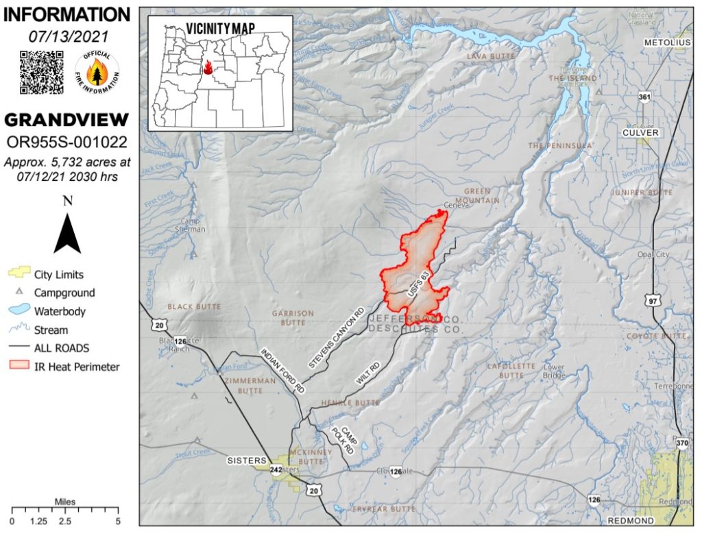
July 13, 2021
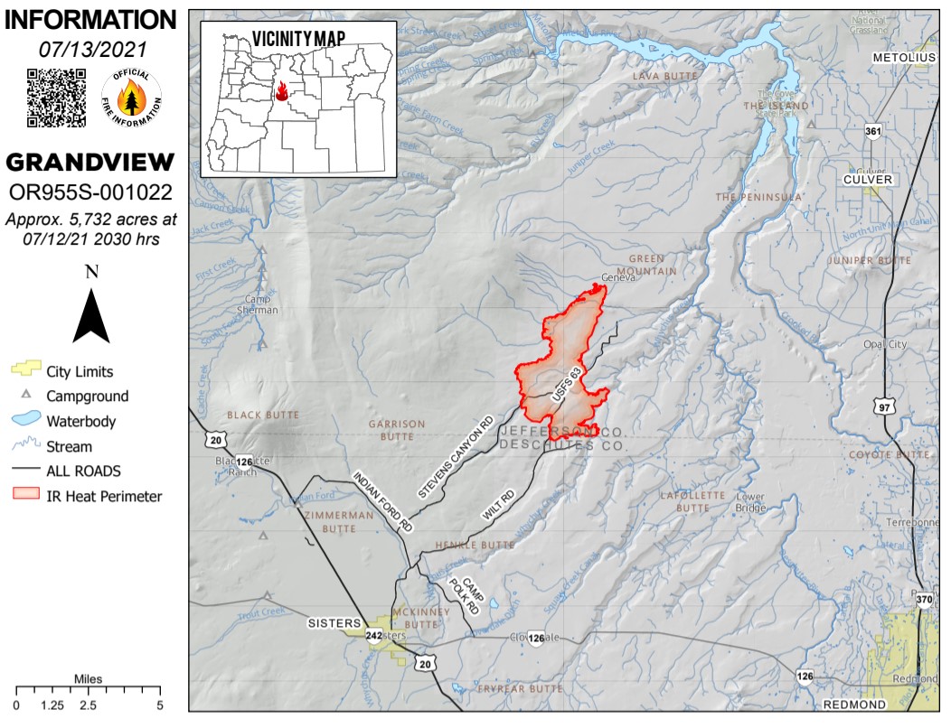
SISTERS, Ore. – Despite continued hot and breezy afternoon conditions, fire behavior has been moderate on the Grandview Fire, which is still estimated to be approximately 5,723 acres burning on private lands protected by the Oregon Department of Forestry and the Crooked River National Grassland managed lands. Firefighters were able to make good progress holding and securing lines around the fire today.
Heavy air tankers dropping retardant were able to assist crews constructing fire line on the southeast portion of the fire while structure protection units led by the Oregon State Fire Marshal’s office continued point protection efforts. This work will tie into existing dozer line on the northeast section of the fire where firefighters are holding the line and beginning to mop up the perimeter to achieve additional containment.
The southwest portion of the fire held within existing fire lines today and crews were able to begin securing fire lines and mopping up. The northwest portion of the fire saw some increased activity this afternoon, but crews and dozers have been actively engaged in constructing fire line and have been assisted by helicopters cooling hot spots.
The National Weather Service has issued a Red Flag Warning for westerly winds 10-20 mph (gusts to 25 mph) coupled with low relative humidity on Wednesday and Thursday. This will challenge efforts to keep the fire within established control lines.
For up-to-date information on the Grandview Fire, please visit: https://inciweb.nwcg.gov/incident/7651/
There are evacuation notices in place issued by the Jefferson County Sheriff’s Office and Deschutes County Sheriff’s Office. Those can be found here: https://arcg.is/5P4LS
July 13, 2021
South Central Oregon Fire Management Partnership (SCOFMP) Joint Information Center (JIC) news release
BEATTY, Ore. — The Bootleg Fire burned another 50,000 acres yesterday. Infrared mapping shows the fire size at 201,923 acres. The fire grew by more than three miles, fueled by extreme drought conditions, single digit humidity, and high temperatures.
The weather forecast shows little signs of relief. The National Weather Service issued a red flag warning through 8:00 p.m. on Wednesday. A heat advisory has also been issued until 8:00 p.m. on Tuesday. Fire managers noted the potential for rapid spread in the coming days.
Al Lawson, Incident Commander of PNW Team 10 encouraged the firefighters to adjust their expectations to the new conditions. “As you go out there today—adjust your reality. We have not seen a fire move like this, in these conditions, this early in the year. Expect the fire to do things that you have not seen before.”
Bootleg Fire South Zone (Zone 1)
A new fire started in the Moccasin Hills area yesterday and led to the evacuation of several residents. Local firefighters, both structural and wildland crews, and air support teamed up and quickly suppressed the five-acre fire.
On the southern edge of the fire, crews were successful in keeping the main fire out of populated areas. The fire burned mostly toward the southeast yesterday. Crews built six miles of dozer line toward Obenchain Reservoir. Firefighters continued to connect and improve dozer lines, install hose lays to extinguish hot spots near structures and along the control, and assess and remove fire damaged trees.
The fire is impacting a high-voltage transmission line. Fire officials and representatives with the power companies are working together on plans to safely re-energize the lines as soon as possible.
Bootleg Fire North Zone (Zone 2):
Fire crews on the North Zone of the fire identified and began to suppress three new fires totaling 150 acres in the Summer Lake area. These crews also built dozer line and set up hose lays to keep the fire west of Forest Road 28.
On the fire’s western flank, crews made good progress in improving dozer line and extinguishing hot spots. Last night, crews continued preparations for burn-out operations down the western slope of Fuego Mountain. Along the northern flank, crews are scouting new locations for safe, effective primary and secondary containment lines.
Oregon Office of State Fire Marshal’s Update:
Yesterday, structural fire crews identified and extinguished spot fires around structures. Firefighters on the northeast side of the fire helped safeguard 11 people when winds pushed the fire toward them. Residents and firefighters retreated into a meadow, a safety zone. Once the fire passed, firefighters returned to the area and continued firefighting around the structures. These firefighters also assisted residents in two vehicles when they became trapped by the fire and were unable to escape because of downed trees. The firefighters removed the trees from the roadway, allowing the group to safely escape.
Other crews extinguished small fires around structures along the fire’s south end.
Evacuations: Lake County (NEW)
Level 3 (GO NOW) Evacuation Notice
- South of the Sycan River, south of Forest Roads 3239 and 28, and the Gearhart Wilderness west of Forest Road 3372 in Lake County.
Level 2 (GET SET) Evacuation Notice
- Sycan Marsh area, Chocktoot Creek Drainage area, west of Forest Road 28 and east of Forest Road 3372, north of Forest Road 34, and through the area that includes Corral Creek Campground and Mitchell Monument.
Level 1 (BE READY) Evacuation Notice
- From the northeast at the Lake County line, through the Yamsay Mountain Recreation Area, extending east to the south of Thompson Reservoir to Winter Rim Recreation Area, then south near the Forest Boundary, then following Chewaucan Road south to Forest Road 34.
Evacuations: Klamath County (will change on 7/13/21)
Level 3 (GO NOW) Evacuation Notice
- Klamath County, north of the town of Beatty. East side of Godowa Springs Rd north of the OC and E Trail to the Klamath County Line need to leave immediately.
- Klamath County, near the town of Sprague River. Upper tableland area north of Oregon Pines Rd need to leave immediately.
Level 2 (GET SET) Evacuation Notice
- Klamath County, near the town of Sprague River. Klamath Forrest Estates/Moccasin Hills Area need to be prepared to leave.
- Klamath County, West side of Godowa Springs Rd, south of Oregon Pines Rd and Tableland Rd. to the river need to be prepared to leave.
Level 1 (BE READY) Evacuation Notice
- Klamath County, Between Beatty and Bly 3 miles south of Highway 140 from Yellow Jacket Springs to Fishhole Creek need to be ready in case.
- Klamath County, the area from the intersection of Sprague River Rd and Forbes Rd extending east to Godowa Springs and Yellow Jacket Springs and south of the Sprague River 4 miles need to be ready in case.
The Klamath County Sheriff’s Office started to issue citations and will make arrests if necessary to keep people out of the Level 3 evacuation areas.
Closures
The Fremont-Winema National Forest is closed to the public in the fire area. See updated map and the Emergency Fire Closure Order 06-02-21-05 on Inciweb at https://inciweb.nwcg.gov/incident/7609/ or on the forest’s website at www.fs.usda.gov/alerts/Fremont-winema/alerts-notices.
Smoke
New fires in Oregon and northern California are contributing to smoke from the Bootleg Fire, with the probability of increasing the smoke layer. If you are sensitive to smoke, check air quality levels at: https://fires.airfire.org/outlooks/southcentraloregon.
Fire Prevention
With Red Flag Warnings early this week, and exceptionally dry conditions, it is critical that area residents and visitors are extremely careful with anything that can potentially spark a wildfire. This includes not driving or parking on dry grass, following public and regulated use restrictions, ensuring chains aren’t dragging and that tires are properly inflated. A small spark can quickly become a large wildfire in minutes.
If you suspect a wildfire, please call 911 to report it immediately. Help our firefighters focus on the Bootleg Fire and not having to respond to new starts!
Phones: 541-363-7765 971-727-7255 541-236-4054
JIC Email: scofmpjic@gmail.com
Inciweb: https://inciweb.nwcg.gov/incident/7609/
Facebook: https://www.facebook.com/BootlegFireInfo
Evacuation: https://tinyurl.com/bootlegevac
| Estimated Size: |
201,923 acres |
| Containment: |
0% |
| Start Date/Time: |
07/06/2021 |
| Location: |
15 miles NW of Beatty, OR |
| Cause: |
Under investigation |
| Personnel: |
1,189 |
| Assigned Resources
Hand Crews:
Engines:
Dozers:
Water Tenders:
Other Heavy Equipment: |
22
133
11
32
3 |
| Assigned Aircraft:
Structure Task Forces: |
10
14 |
| Structures Threatened: |
1,926 |
| Evacuations: |
Evacuations in effect. See above.
Level 3 (GO)
Level 2 (BE SET)
Level 1 (BE READY) |
July 13, 2021
SISTERS, Ore. – Oregon Department of Forestry’s Incident Management Team 2, led by Incident Commander Matt Howard, and Oregon State Fire Marshal Office Red Team, Incident Commander Ian Yocum, have joined in unified command on the Grandview Fire northeast of Sisters. The arrival of the fire management organization brings in additional overhead capacity and firefighting resources.
The fire is estimated at 5,723 acres and 5 percent contained.
Governor Kate Brown enacted the Conflagration Act yesterday afternoon allowing additional resources throughout the state to mobilize to the Grandview Fire. The Oregon State Fire Marshal Office mobilized task forces from Marion, Yamhill, Linn, Benton, Lane, Umatilla and Columbia County in addition to a hand crew out of Clackamas County to protect the 421 homes that are under threat from the Grandview Fire. The arrival of these resources will build on the tremendous work that local firefighters accomplished the last two days and allow them to be ready for new fires and other emergency calls for service within their fire district.
Persistent winds from the north and east have pushed the fire to the southwest into Stevens Canyon. While much of the east side of the fire is lined, there are a few areas of concern along Whychus Creek. Firefighters have been holding the fire west of Whychus Creek, while picking up small spot fires that have crossed over. Despite the active fire behavior, fire crews and aircraft are having success throughout much of the fire area. Much of the east and south portions of the fire, that pose the most threat to populated areas, have containment lines in place. Crews will continue to tie a few areas together and strengthen the edges through mop-up operations.
Red Cross has set up a temporary evacuation shelter at Sisters Middle School. The Deschutes County Fairgrounds is accepting animals. For the Pet Evacuation Team, call 541-610-6628. Please follow the Deschutes and Jefferson County Sheriff’s office at https://sheriff.deschutes.org/ or https://www.jeffco.net/sheriffdeschutescountysheriff.
Grandview Fire Information: 541-633-7410 (7 a.m. – 9 p.m.)
Email: grandviewfire.information@gmail.com
Facebook: https://www.facebook.com/ODFCentralOregon
Twitter: @CentralORFire
Oregon Department of Forestry IMT 2 Matt Howard, Incident Commander and Oregon State Fire Marshal’s Red Team Ian Yocum, Incident Commander
Grandview Fire map as of July 12, 2021.
July 13, 2021
Email: 2021.jack@firenet.gov
Phone: 541-201-2335
Hours: 8 a.m. – 6 p.m.
InciWeb: https://inciweb.nwcg.gov/incident/7605
Facebook: https://fb.me/JackFire2021
Northwest Incident Management Team 9 (IC Brian Goff)
SIZE: 13,795 acres
CONTAINMENT: 15%
PERSONNEL: 755
CAUSE: Under Investigation
Location: East of Glide, OR in the Umpqua National Forest
South of HWY 138, crews have established anchor points on the western and eastern flanks. Working from the anchor points near Twin Lakes, crews are utilizing trails, roads, and hand lines to hold the fire near Calf Creek. On the western perimeter of the fire, crews are holding the line and will continue to burn vegetation where necessary to prevent fire spread east of the 4714 road. On the southern-most edge of the fire, resources continue to prepare containment lines while also scouting for control line options closer to the fire’s active front.
Structures: Oregon State Fire Marshal’s Task Forces have demobilized and delegation of authority transferred back to Douglas Forest Protective Association. Structures have been prepped, structure protection enhance and will be monitored by DFPA and NW Team 9.
Aviation: Air assets continue to provide ground resources with water and retardant drops to limit the spread of the fire and to help establish and hold containment lines. Aviation and fire crews coordinate with resource advisors to protect area water resources, reduce spread of invasive species and minimize impacts of fire suppression tied to water and retardant drops.
Evacuations: All Forest Service campgrounds (Apple Creek, Horseshoe Bend and Eagle Rock) are on Level 3 evacuation GO order. The Dry Creek community as well as all residences on the Illahee Road are also in Level 3 evacuation GO order. Level 2 SET evacuations were issued from mile marker 38 to 43. This includes Steamboat Inn and residences located on Brindle Bug Road, Steelhead Caddis Road, and residences and businesses located between mile post 51 and 55 on Highway 138E. Please visit the Douglas County Sheriff’s Office interactive evacuation map: www.dcso.com/evacuations
Closures: State highway 138E from Steamboat Creek to mile post 55 is closed to vehicle traffic. Steamboat Inn is also closed. Oregon Department of Transportation has set an eastside ‘soft closure’ checkpoint at Lemolo Lake junction to allow for local access into nearby recreation areas, including Lemolo Lake. Please visit https://tripcheck.com/ for updates on road closures. The Umpqua National Forest has issued an area closure around the Jack Fire. The full closure order and map can be viewed on InciWeb or at https://go.usa.gov/xGJSE.
Weather: Temperatures again in the 90’s today with relative humidity at 20%. Winds will be light from the east northeast in morning, changing west northwest in afternoon, with gusts up to 15 miles per hour.
July 12, 2021
Fire info line: 541-316-7711
Joint news release:
Central Oregon – Firefighters worked through the night on the Grandview Fire, burning on private lands protected by the Oregon Department of Forestry and the Crooked River National Grassland managed by the US Forest Service.
By morning, crews and dozers had preliminary containment lines or retardant around the majority of the 4,000 acre fire area 8 miles east of Black Butte, west of Whychus Creek. Fire behavior was extremely active yesterday afternoon and through the evening hours and crews were challenged by numerous spot fires and group tree torching. Today, fire growth has been westerly, pushed by an east wind but forecasted northwest winds are beginning to push on preliminary fire lines to the south. A Central Oregon task force of structure fire engines, including one from Marion County, have been focused on point protection around Holmes Road and Squaw Creek Canyon Estates.
Today, crews are holding and securing the fire lines put in place by several dozers with the assistance of five large air tankers dropping retardant to decrease fire behavior, and two helicopters dropping water to cool hot spots. A Central Oregon Fire Management Service (COFMS) Type 3 team has been in command of the fire and will transition to a Type 1 Oregon Department of Forestry team at 6:00 p.m. today.
For up-to-date information on the Grandview Fire, please visit: https://inciweb.nwcg.gov/incident/7651/
July 12, 2021
SCOFMP Joint Information Center – Bootleg Fire Information Update
Monday, July 12, 2021, at 1 P.M.
Beatty, Ore.— Due to the size and complexity of the Bootleg Fire, the fire will be managed using two zones—this will allow the incident management teams to better manage the fire and limit travel for firefighters. ODF Incident Management Team 1 took command of the fire’s south part, or Zone 1, today. Pacific Northwest Team 10 manages the north part, or Zone 2. Oregon Office of State Fire Marshal’s Green Team continues to protect structures.
After three days of explosive growth, a smoke inversion moderated fire activity and allowed fire crews to construct and improve fire control lines yesterday. Rather than doubling in size like prior days, the fire added 5,000 acres to the perimeter raising the total acreage to just above 150,000.
Zone 1 Update: The control lines on the southern edge of the fire kept the fire in check overnight. Near communities of Klamath Forest Estates, Moccasin Hills, and Tablelands, crews used the favorable conditions to build and connect dozer lines, extinguish hot spots near structures, and assess fire damaged tree hazards. More crews will be working night shift as overnight temperatures moderate fire activity, allowing crews to make more progress. In the east, crews continue to work in Sycan Estates area to extinguish hot spots and remove fire damaged trees near structures. Power companies are inspecting damage to the high voltage powerlines to determine if they can safely return power to those lines. Along the eastern flank, crews are scouting new locations for safe, effective primary and secondary containment lines.
Zone 2 Update: Firefighting and containment efforts continue through the day. Tonight, like in Zone 1, more crews will work the night shift. Crews on the west side are connecting containment lines along forest roads to prepare for a controlled burn to enforce those lines. Along the north, crews are scouting new locations for safe, effective primary and secondary containment lines too.
Oregon Office of State Fire Marshal’s (OSFM) Update: Crews from structural fire departments continue focusing on protecting structures and residences. Firefighters are identifying, triaging, and removing brush and small trees around homes on outside the fire’s south and east sides.
Protecting homes has been a team effort between structure firefighters and wildland fire crews to save homes. Quick actions from crews on the ground prevented numerous homes from catching fire during nighttime ember showers.
Structure resources will continue to patrol and identify structures at risk. They are starting to assess damage and looking for damaged or destroyed structures.
Evacuations
Level 3 (GO NOW) Evacuation Notice
- Klamath County, north of the town of Beatty. East side of Godowa Springs Rd north of the OC and E Trail to the Klamath County Line need to leave immediately.
- Klamath County, near the town of Sprague River. Upper tableland area north of Oregon Pines Rd need to leave immediately.
Level 2 (GET SET) Evacuation Notice
- Klamath County, near the town of Sprague River. Klamath Forrest Estates/Moccasin Hills Area need to be prepared to leave.
- Klamath County, West side of Godowa Springs Rd, south of Oregon Pines Rd and Tableland Rd. to the river need to be prepared to leave.
Level 1 (BE READY) Evacuation Notice
- Klamath County, Between Beatty and Bly 3 miles south of Highway 140 from Yellow Jacket Springs to Fishhole Creek need to be ready in case.
- Klamath County, the area from the intersection of Sprague River Rd and Forbes Rd extending east to Godowa Springs and Yellow Jacket Springs and south of the Sprague River 4 miles need to be ready in case.
The Klamath County Sheriff’s Office started to issue citations and will make arrests if necessary to keep people out of the Level 3 evacuation areas.
Smoke
New fires in Oregon and northern California are contributing to smoke from the Bootleg fire, with the probability of increasing the smoke layer. If you are sensitive to smoke, check air quality levels at: https://fires.airfire.org/outlooks/southcentraloregon.
Closures
The Fremont-Winema National Forest is closed to the public in the area of the fire. See updated map and the Emergency Fire Closure Order 06-02-21-03 on Inciweb at https://inciweb.nwcg.gov/incident/7609/ or on the forest’s website at www.fs.usda.gov/alerts/Fremont-winema/alerts-notices.
July 12, 2021
National: Preparedness Level 4 (Geographic areas competing for wildland fire suppression resources. Three or more geographic areas experiencing large, complex fires.)
|
# of fires |
Acres burned |
| Total to date |
30,219 |
1,389,087 |
Oregon: Preparedness Level 4 (Heavy commitment of NW resources and significant import from outside NW necessary to meet incident demands and maintain preparedness.)
| Only ODF-protected lands (16 million acres) |
| |
# of fires |
Acres burned |
| 2021 year-to-date |
544 |
49,672 |
10-year avg. year-to-date
(2011 – 2020) |
324 |
4,683 |
| All lands in Oregon (Includes ODF-protected lands) |
| |
# of fires |
Acres burned |
| 2021 year-to-date |
918 |
164,677 |
Current large fires in Oregon: Includes all lands
| Name |
Date |
Total Acres |
ODF Acres |
Containment |
Location |
Cause |
Notes |
| Bootleg |
July 6, 2021 |
153,535 |
39,000 |
0% |
North of Sprague River and Beatty |
Unknown |
ODF IMT 1 mobilized in unified command with OSFM & federal teams. Evacuations.
Fire information |
| Grandview |
July 12, 2021 |
4,000 |
Est. 1,000 |
0% |
SW of Culver |
Unknown |
ODF IMT 2 mobilized. Evacuations.
Fire information |
| Jack |
July 5, 2021 |
12,533 |
0 |
10% |
20 M East of Glide |
Unknown |
NW Team 9 (IMT2). Evacuations.
Fire information |
| Lewis Rock |
June 30, 2021 |
368 |
300 |
80% |
4.5 M S of Mitchell |
Lightning |
ODF IMT 3 demobilized Sunday. Last report unless new activity. |
| Green Ridge |
July 7, 2021 |
175 |
0 |
0% |
30 M E of Walla Walla, Wash. |
Lightning |
NW Team 7 (IMT2) in-brief 7/12.
Fire information |
More information:
More hot, dry weather in the forecast with poor humidity recovery maintains elevated potential for new significant fire development east of Cascades and in southwest Oregon. Cooler weather toward end of week might moderate some.
July 12, 2021
La Grande, ORE. – Wildfire risk is rising rapidly due to a combination of extreme heat and prolonged drought to reduce the risk, additional restrictions for industrial forest operations in Oregon Department of Forestry in Northeast Oregon will be in effect at 12:01 a.m. July 14, 2021.
These restrictions are intended to decrease potential fire eruptions resulting from logging and other forest operations. With tinder-dry forest fuels, it increases the chance of a spark or cinder igniting a wildland fire. The Industrial restriction for operations affects private, state, county, municipal, and tribal lands in seven counties: Union, Baker, Wallowa, Umatilla, and small portions of Malheur, Grant, and Morrow Counties. Remember, “Only you can prevent wildfires!” We ask everyone to be extremely careful and be vigilant with other ignition sources.
REQUIRED SHUT DOWN: Except at landings, the use of mechanized harvesters with a high-speed saw, chainsaws, tracked felling or skidding equipment, slash busting equipment, and cable yarding systems are prohibited between the hours of 12:00 p.m. and 8:00 p.m. local time.
The requirements listed above are in addition to the normal fire season requirements as listed in “A Guide to Legal Requirements for Preventing and Controlling Fires in Operations on and Near Forestland in Oregon,” such as spark arresters, water supply, tools, fire extinguishers and watchman service.
Operators should refer to www.oregon.gov/odf/fire/Documents/fire-season-requirements-for-industrial-operations.pdf for information specific to industrial operations during fire season or call their local ODF Office.
The Umatilla and Wallowa-Whitman National Forests, as well as the BLM are currently under public use restrictions. Current fire restrictions for forestlands in Northeast Oregon can be found at www.bmidc.org. The Northeast Oregon Fire Prevention line is (541) 975-3027.
http://bluemountainfireinfo.blogspot.com/ is your spot for current fire information in the Blue Mountains.
Find us on Facebook at: https://www.facebook.com/oregondeptofforestryNEO/
To report a fire, call Blue Mountain Interagency Dispatch at (541)963-7171 or dial 9-1-1.
July 12, 2021
JACKSON & JOSEPHINE COUNTIES, ORE. – The fire danger level on lands protected by the Oregon Department of Forestry in Jackson and Josephine counties rises to “extreme” (red) at 12:01 a.m. on Wednesday, July 14, 2021. This affects 1.8 million acres of state, private, county and Bureau of Land Management lands within ODF’s Southwest Oregon District. The Industrial Fire Precaution Level (IFPL) will remain at Level 2 (two).
The primary difference between current fire prevention restrictions and those beginning on Wednesday affects the public use of power-driven equipment, such as chain saws and mowers. The use of power-driven equipment, grinding, cutting of metal, and other spark-emitting equipment, such as wood splitters and generators, will be prohibited.
Here are the details of the adjusted fire restrictions taking effect on July 14:
- The use of power saws is prohibited.
- The cutting, grinding and welding of metal is prohibited.
- The mowing of dry or dead grass is prohibited.
- The operation of any other spark-emitting internal combustion engine not specifically mentioned above is prohibited.
The following fire prevention regulations are currently in effect and will remain in effect until the fire danger level drops significantly:
- Smoking is prohibited while traveling, except in vehicles on improved roads, in boats on the water, and designated locations.
- Debris burning is prohibited.
- Burn barrel use is prohibited.
- Open fires are prohibited, including campfires, charcoal fires, cooking fires and warming fires, except in approved fire rings at designated campgrounds. In other locations, portable cooking stoves using liquefied or bottled fuels are allowed.
- Motor vehicles, including motorcycles and all-terrain vehicles, may only be used on improved roads free of flammable vegetation, except when used for the commercial culture and harvest of agricultural crops.
- Fireworks on or within 1/8th of a mile of forestland are prohibited.
- Any electric fence controller in use shall be listed by a nationally recognized testing laboratory or be certified by the Department of Consumer and Business Services; and operated in compliance with the manufacturer’s fire-safe instructions.
- The use of exploding targets is prohibited.
- The use of tracer ammunition or any bullet with a pyrotechnic charge in its base is prohibited.
- Possession of the following firefighting equipment is required while traveling, except on state highways, county roads and driveways: one shovel and one gallon of water or one 2.5 pound or larger fire extinguisher. All-terrain vehicles and motorcycles must be equipped with one 2.5 pound or larger fire extinguisher.
For more information about the Oregon Department of Forestry’s fire season restrictions, visit our website, www.swofire.com or our Facebook page @ODF Southwest Oregon District.
July 11, 2021
Email: 2021.jack@firenet.gov
Phone: 541-201-2335
Hours: 8am-6pm
InciWeb: https://inciweb.nwcg.gov/incident/7605
Facebook: https://fb.me/JackFire2021
Northwest Incident Management Team 9 (IC Brian Goff)
Oregon State Fire Marshal Blue Incident Management Team (IC Scott Magers)
SIZE: 10,937 acres
CONTAINMENT: 10%
PERSONNEL: 781
CAUSE: Under Investigation
Fire information: The Jack Fire is currently estimated at 10,937 acres and is 10% contained. In the northern section of the fire, crews have completed handline and conducted mop up 20 feet inside of the perimeter along the 4713 Road. Mop-up involves seeking out and cooling of heat sources. Today these crews will maintain, secure, and mop-up the line moving to the east utilizing dozers, handline, and hose lays. On the western edge of the fire, resources continue to brush out vegetation while holding and securing the line along the river and HWY 138. On the northeastern perimeter, fire activity is minimal, with creeping and smoldering into the rocky steep ridge. Crews in this section will be scouting safe containment line locations to limit the fire spread. In the southeast, resources have burned vegetation along containment lines to connect the 4760 Road to the areas that have been cleared of vegetation near Dry Creek and Illahee Road. The most active area of the fire is south of the river and HWY 138. Firefighters have established locations that are suitable for containment lines while providing for firefighter safety. Crews working on all sections of the fire face steep terrain and poison oak related difficulties.
Structures: Structure crews and Douglas Forest Protective Association continue to support fire operations in the Dry Creek area creating defensible space on private property and assessing structures for fuel removal. Task forces are also moving east along HWY 138, scouting additional homes and buildings for fire prevention groundwork. To date, firefighters have successfully protected community with zero structure loss.
Aviation: Yesterday, four Type 1 helicopters and one Type 3 helicopter provided support to ground crews in the afternoon. A strong smoke inversion Friday morning created poor visibility and prevented aircraft from flying until later in the day.
Evacuations: All Forest Service campgrounds (Apple Creek, Horseshoe Bend and Eagle Rock) are on Level 3 evacuation GO order. The Dry Creek community as well as all residences on the Illahee Road are also in Level 3 evacuation GO order. Level 2 SET evacuations were issued from mile marker 38 to 43. This includes Steamboat Inn and residences located on Brindle Bug Road, Steelhead Caddis Road, and residences and businesses located between mile post 51 and 55 on Highway 138E. Please visit the Douglas County Sheriff’s Office interactive evacuation map: www.dcso.com/evacuations
Closures: State highway 138E from Steamboat Creek to mile post 55 is closed to vehicle traffic. Steamboat Inn is also closed. Oregon Department of Transportation has set an eastside ‘soft closure’ checkpoint at Lemolo Lake junction to allow for local access into nearby recreation areas, including Lemolo Lake. Please visit https://tripcheck.com/ for updates on road closures. The Umpqua National Forest has issued an area closure around the Jack Fire. The full closure order and map can be viewed on InciWeb or at https://go.usa.gov/xGJSE.
Weather: Forecast for near normal temperatures in the 80’s with winds west to northwest.
July 11, 2021
NOTE: An ODF Type 1 Incident Management Team has deployed to the Bootleg Fire and will be in unified command with the Oregon Office of State Fire Marshal and federal teams.
FIRE INFORMATION: 541-363-7765, 2021.bootleg@firenet.gov
INCIWEB: https://inciweb.nwcg.gov/incident/7609/
Facebook: SCOFMP Fire Info
Facebook: Northwest Incident Management Team 10
Facebook: Fremont-Winema NF
SIZE: 143,607 acres
CONTAINMENT: 0%
PERSONNEL: 926
CAUSE: Under Investigation
RESOURCES:
Hotshot crews 3
Type II Initial Attack Crews 6
Type II Crews 10
Engines 83
Dozers 6
Water Tenders 25
AIRCRAFT:
Helicopters 10
Data as of 7/11/21: Noon
The Bootleg Fire continues to burn on the Fremont-Winema National Forest and on private lands. Hot/dry weather and extremely dry fuels contribute to extreme fire behavior. Two Type 1 Teams are being added to manage the fire. A surge force of structure protection resources is also arriving.
OPERATIONS
Yesterday/Last Night: Firefighters, emergency managers and other public safety officials faced the fifth day in a row of extreme, intense fire behavior on the Bootleg Fire, as hot, dry, windy weather persists in the area. These conditions escalated in the afternoon, resulting in immediate, life-threatening risk to public and emergency responder safety.
Conditions were so extreme that firefighters needed to disengage and move to predetermined safety zones. Fire managers evaluated conditions and looked for opportunities to reengage firefighters safely.
This extreme fire behavior resulted in approximately 4 miles of fire growth both to the east and north. The fire moved through Sycan Estates, crossed the East-West road, and burned about 8 additional miles along the high voltage powerline corridor (for a total of 12 miles). Damage to structures and infrastructure is being assessed; some structures have been lost. There have been no reported fatalities.
On the south west side of the fire, light winds and lighter fuel conditions allowed firefighters, structure protection teams, and air support to be successful in minimizing fire growth toward the south (communities of Klamath Forest Estates/Moccasin Hills, Tablelands). Western movement of the fire toward Chiloquin was also minimal.
Today: While firefighting and containment efforts continue through the day, fire managers are adding more crews to night shift because weather conditions are better for fighting the fire as well as for building containment lines. Crews are also working on structural triage, defensible space and protection. Following yesterday’s significant fire growth, crews are scouting new locations for safe, effective primary and secondary containment lines around the entire fire perimeter. Aircraft (helicopters and fixed wing water and retardant drops) are being used to assist on-the-ground crews. However, flights will be grounded if any type of drone activity is spotted in the area.
EVACUATIONS
Due to rapid fire movement, evacuation areas and levels are being updated as conditions change. The fastest way to find the latest information on evacuations is to subscribe to the Klamath County Sherriff’s office Emergency Alerts at: http://Alerts.KlamathCounty.org and/or use a phone to scan this QR code for a map of the fire and evacuation zones. Evacuation Center: Klamath County Fairgrounds (in Klamath Falls), South 6th Street entrance only.
EVACUATION ORDERS AS OF 7/11/21 on 10:30 a.m.
Level 3 (GO NOW) EVACUATION NOTICE
Klamath County, north of the town of Beatty. East side of Godowa Springs Rd north of the OC and E Trail to the Klamath County Line. is under LEVEL 3 (GO NOW) Evacuation Notice.
Level 3 (GO NOW) EVACUATION NOTICE
Klamath County, near the town of Sprague River. Upper tableland area north of Oregon Pines Rd are under level 3 evacuation notice and need to leave immediately.
Level 2 (GET SET) Evacuation Notice
Klamath County, near the town of Sprague River. Klamath Forrest Estates/Moccasin Hills Area is under level 2 (GET SET) evacuation notice and need to be prepared to leave.
Level 2 (GET SET) Evacuation Notice
Klamath County, West side of Godowa Springs Rd, south of Oregon Pines Rd and Tableland rd. to the river is under level 2 (GET SET) evacuation notice and need to be prepared to leave.
Level 1 (BE READY) Evacuation Notice
Klamath County, Between Beatty and Bly 3 miles south of Highway 140 from Yellow Jacket Springs to Fishhole Creek is under Level 1 (BE READY) Evacuation Notice.
Level 1 (BE READY) Evacuation Notice
Klamath County, The area from the intersection of Sprague River Rd and Forbes Rd extending east to Godowa Springs and Yellow Jacket Springs and south of the Sprague River 4 miles is under Level 1 (BE READY) Evacuation Notice.
PUBLIC AND FIREFIGHTER SAFETY: There is a high potential for extreme fire behavior and movement on all sides of the fire. The Klamath County Sheriff’s Office has begun to issue citations and will make arrests if necessary to keep people out of the level 3 evacuation areas. People have been advised to evacuate over the last several days, some have not listened and continue to travel within the restricted area. This violates the closure restrictions and interferes with firefighting and lifesaving efforts. Residents in Level 3 Evacuation Area PLEASE EVACUATE IMMEDIATELY. There is a VERY high probability officers may not be able to get to you with additional warnings.
Watch for increased fire equipment traffic on area roads and highways. Do not fly drones in the vicinity of the fire; drone activity will cause grounding of all airborne firefighting resources.
PUBLIC INFORMATION
In-person fire information opportunities
Today, fire and county officials will be at the following sites to provide information and answer questions. Because the team will make multiple stops, times listed are approximate.
• Sprague River Community Center, 1 – 1:30 p.m.
• Beatty Community Center, 1:45 – 2:15 p.m.
• Bly Community Center, 2:30 – 3 p.m.
• Paisley at 1032 West Street, 4:30 – 5 p.m.
• Summer Lake Lodge at 53460 Highway 31, 5:30 – 6 p.m
Fire information boards, updated daily, are located at:
• Chiloquin: Public Parking Lot
• Chiloquin: Crater Lake Junction Travel Center (KLA-MO-YA Casino)
• Beatty: Community Center
• Sprague River: Community Center
• Bly: Ranger District Office
• Bly: Breadwagon
• Klamath Falls: Klamath County Fairgrounds Red Cross Evacuation Center
SMOKE: Smoke is expected to continue to impact the local area. If you are sensitive to smoke, check air quality levels at https://fires.airfire.org/outlooks/southcentraloregon.
CLOSURES
The Fremont-Winema National Forest is closed to the public in the area of the fire. See the updated map and the Emergency Fire Closure Order 06-02-21-03 on Inciweb (Google “Inciweb Bootleg Fire”) or on the forest’s website at www.fs.usda.gov/alerts/Fremont-winema/alerts-notices.
July 10, 2021
Mitchell, ORE. – Today firefighters on the Lewis Rock Fire will face the hottest temperatures of the weekend. And while fire activity has diminished, the heat and single-digit relative humidity could promote active burning in pockets of unburned fuels within the fire’s perimeter.
Despite challenging firefighting conditions, fire crews continue to have success, increasing containment to 60 percent. The size of the fire remains 368 acres.
Mopup has reached as much as 150 feet from containment lines to the interior in several areas around the fire. To assure full containment on a fire of this scale that involves large, heavy forest fuels, firefighters are shooting for 300 feet in most areas. Continuing reduction in smoke will occur as residual fuels are consumed.
As the summer fire season progresses, homeowners and communities are encouraged to create defensible space that will help homes survive destructive wildfires. Go to Firewise.org for more information.
Current fire restrictions and information for ODF’s Central Oregon District is available at www.odfcentraloregon.com.
Inciweb: https://inciweb.nwcg.gov/incident/7604/
| Fire Size:
Containment: |
368 acres
60% |
| Start Date: |
June 30, 2021 |
| Location: |
5 miles south of Mitchell, OR |
| Cause: |
Lightning |
| Personnel: |
386 |
| Assigned Resources |
|
| Hand Crews: |
14 |
| Engines: |
45 |
| Dozers: |
3 |
| Water Tenders: |
11 |
| Other Heavy Equipment: |
3 |
| Helicopters: |
2 |
| Injuries: |
0 |
| Structures Threatened: |
0 |
| Structures Damaged: |
0 |
| Structures Destroyed: |
0 |
| Evacuations: |
None |
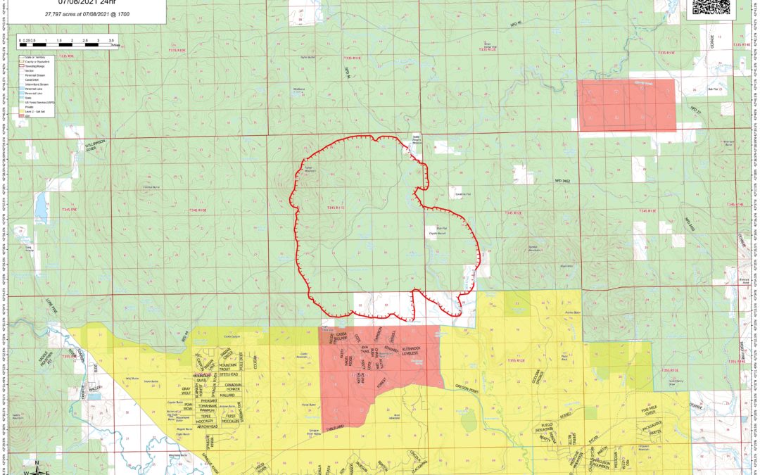
July 9, 2021
NOTE: Bootleg Fire crossed onto ODF-protected lands yesterday.
NORTHWEST INCIDENT MANAGEMENT TEAM 10
Incident Commander: Al Lawson
FIRE INFORMATION: 541-363-7765, 2021.bootleg@firenet.gov
INCIWEB: https://inciweb.nwcg.gov/incident/7609/
Facebook: SCOFMP Fire Info
Facebook: Northwest Incident Management Team 10
Facebook: Fremont-Winema NF
SIZE: 38,892 acres
CONTAINMENT: 0%
PERSONNEL: 328
CAUSE: Under Investigation
RESOURCES:
Hand Crews 19
Engines 22
Dozers 2
Water Tenders 3
AIRCRAFT:
Helicopters 10
Data as of 7/9/21: 8 a.m.
Bootleg Fire perimeter map for July 9, 2021.
The Bootleg Fire continues to burn on the Fremont-Winema National Forest and private lands north of the towns of Sprague River and Beatty. Although the Red Flag Warning is no longer in effect, weather conditions overnight and through today continue to allow for extreme fire behavior. Additional resources have been ordered and continue to arrive.
Yesterday’s operations: Firefighters continued their efforts to identify defensible locations for effective fire breaks and to safely engage the fire. Crews were successful at limiting the spread along the southern edge. However, during the day and into the evening, wind-driven extreme fire behavior resulted in active fire growth to the east. Officials are in the process of assessing the impacts of yesterday’s fire spread. Today’s operations: In addition to on-going daytime operations, more crews are being assigned to night shift when conditions are more favorable for effective firefighting. As part of the unified command and in addition to the wildland firefighting efforts underway, the Office of the Oregon State Fire Marshal’s Green Incident Management Team remains on scene with 3 taskforces focused on structural triage and, when possible, creating defensible space around structures on both day and night shift. Today, 2 more structural strike teams from California and an Oregon taskforce have arrived, with additional resources on order.
Evacuations: At the recommendation of the Bootleg Fire Incident Commander, following are the current evacuation levels issued by Klamath County Emergency Management: Level 3 (Go) – Leave immediately
• (NEW) North of the town of Beatty. North end of Godawa Springs Road north of the rock quarry.
• Near the town of Sprague River. Upper Tableland area north of Oregon Pines Road.
• North of the town of Beatty. Sycan Estates area.
Level 2 (Get Set) – Be ready to leave at a moment’s notice
• North of the town of Beatty. The area north of Highway 140, on both sides of Godowa Springs Road, south of the rock quarry.
• North of the town of Sprague River. Klamath Forest Estates/Moccasin Hills area.
Evacuation Center
Klamath County Fairgrounds (in Klamath Falls), South 6th Street entrance only.
Public meetings:
• 11 a.m. – Sprague River Community Center
• 7 p.m. – Chiloquin Community Center
• Attend the meetings in person or watch the 7 p.m. meeting on Facebook Live on SCOFMP Fire Info, Northwest Team 10 and Fremont-Winema National Forest Facebook pages.
Closures: The Fremont-Winema National Forest is closed in the area of the fire. See maps and the Emergency Fire Closure Order 06-02-21-03 at www.fs.usda.gov/alerts/Fremont-winema/alerts-notices or on Inciweb.
Safety Message: Watch for increased fire equipment traffic on area roads and highways, particularly in the Chiloquin area – use caution and drive defensively!
FIRE PREVENTION: Conditions are unseasonably hot and dry this year. Please use caution with anything that can spark a fire! Report suspected wildfires immediately to 911.
SMOKE: Smoke is expected to continue to impact the local area. Find more info at www.oregonsmoke.blogspot.com.