PRINEVILLE, Ore. – Overnight, firefighters used handheld infrared sensors to detect remaining hotspots within 75 feet of the line. These were marked for continuing mop-up efforts today. Today, firefighters will build on the progress made overnight by continuing mop-up operations and working to increase the depth of containment around the fire’s edge. Firefighters will also patrol the perimeter to detect and extinguish remaining heat and smoke. In areas where the fire is contained, suppression repair work will begin. This includes repairing dozer lines, installing water bars, and other actions to help reduce erosion and support long-term recovery.
Resources assigned to the Marks Creek Fire remain prepared to respond to any new fire starts, and aerial resources will be available to support suppression efforts as conditions allow.
The weather today is expected to bring widespread rain events in the afternoon through the evening, and variable winds from the Northwest. Moderate instability will bring chances of lightning at 15-20%. Wetting rains may increase driving and access challenges. Fire crews remain vigilant and ready to respond to changing conditions.
Highway 26 remains open; however, firefighters and heavy equipment are entering and exiting the roadway in multiple areas along the fire perimeter. Please drive with caution and slow down in the fire area to ensure firefighter and public safety.
Evacuations: Crook County Sheriff’s Office evacuation orders remain in place. An evacuation map is available on the Crook County Sheriff’s Facebook page at www.facebook.com/CrookCountySheriff/.
LOWER ROGUE RIVER CORRIDOR, Ore. – Oregon Department of Forestry’s (ODF) Complex Incident Management Team 1, Incident Commander Dan Quinones, assumed command of the Kelsey Peak Fire today at 6:00 a.m. Resources from the Bureau of Land Management (BLM) Medford District and ODF’s Southwest Oregon District have made significant progress constructing containment lines on the Kelsey Peak Fire since it was sparked by lightning last week. The fire is burning on BLM administered lands in rugged terrain with dense vegetation, limited access, and large overstory trees north of the Rogue River along the Kelsey Creek drainage.
Transitioning command of the fire to Team 1 brings additional capacity and resources to the incident and allows local firefighters to rest and be available to respond to new fires. The weather forecast for the week includes cooler temperatures, precipitation and the threat of more lightning.
Fire crews today will take advantage of the cooler, damp weather to further strengthen existing control lines, identify potential features and points to establish direct control lines, and building line adjacent to the fire’s edge, minimizing fire size. Smoky conditions have limited the use of aircraft on the fire over the last several days, as conditions allow, they will be used to support firefighters on the ground. Eight helicopters are assigned to the incident.
On the west side of the fire, control lines will be extended with bulldozers south from BLM Road 32-9-14.2, while firefighters look for opportunities to build direct line along the southern edge of the fire. Overnight, access to the northeast corner of the fire was improved as bulldozers worked to open a roadway for firefighter travel. Better access to this area of the fire will allow construction of direct control line along the northern edge of the fire and the east side of the fire working south toward the East Fork of Kelsey Creek.
“We have a window of opportunity to take strong action on the fire,” commented Incident Commander Quinones during the day shift planning meeting. “Moderated fire behavior will allow us to go after the fire in its existing footprint.”
While focusing on the full suppression operational objectives of the incident, special consideration will be given to the protection of cultural and historic resources in the area, public and firefighter safety, and minimizing impacts to the natural characteristics of the Rogue River and its tributaries. The Rogue River remains open for permitted boaters, however firefighting activities in the area could cause delays.
Firefighting resources from the Kelsey Peak Fire are available to support local agency’s initial attack of new wildfires.
Closures: The Rogue River Trail is closed from Horseshoe Bend to Flora Dell.A temporary closure of a portion of the Grave Creek to Marial Backcountry Byway (BLM Road 32-9-14.2) has been implemented by the BLM Grants Pass Field Office. The public is strongly encouraged to avoid the entire Byway to facilitate safe firefighter access on the steep, narrow, windy road. Members of the public may not enter closed areas, and all uses—including hiking, hunting and dispersed camping—are prohibited. Please see the map for full closure information on the BLM website: https://www.blm.gov/programs/public-safety-and-fire/fire-and-aviation/regional-info/oregon-washington/fire-restrictions.
Evacuations: The Curry County Sheriff’s Office issued a Level 3 – GO NOW evacuation order for the area of Rogue River Ranch, Tucker Flat Campground and the nearby area of Marial. The Josephine County Sheriff’s Office and Emergency Management issued a Level 1 – BE READY evacuation notice Zone JCU-801. More info: https://tinyurl.com/KelseyPeakEvacs
Temporary Flight Restriction (TFR): A “TFR” is in place at an altitude from the surface up to and including 7,000 feet, daily (24 hours) until further notice. Complete information is available at https://tfr.faa.gov/tfr3/?page=detail_5_8274. Flying a drone near or around a wildfire compromises the safety of pilots and interferes with firefighting efforts.
PRINEVILLE, Ore. – With more seasonable weather conditions across the fire area today, crews continued to make progress around the entire fire. With the fire now fully lined, tree fallers focused on clearing hazardous snags, going over 100 feet deep in some areas. By removing these danger trees, crews were able to safely work into the interior of the fire further securing the perimeter.
Overnight crews will continue to build depth to the lines in areas with easier access. They will use infrared sensors to find and mark areas of heat in the interior so day crews can extinguish them.
Highway 26 remains open; however, firefighters and heavy equipment are entering and exiting the roadway in multiple areas along the fire perimeter. Please drive with caution and slow down in the fire area to ensure firefighter and public safety.
Evacuations: Crook County Sheriff’s Office evacuation orders remain in place. An evacuation map is available on the Crook County Sheriff’s Facebook page at www.facebook.com/CrookCountySheriff/.
LOWER ROGUE RIVER CORRIDOR, Ore. (Sept. 7, 2025) – As firefighters remain engaged on the Kelsey Peak Fire, Oregon Department of Forestry (ODF) Complex Incident Management Team (CIMT) 1 was in-briefed on the incident by local leadership from the Bureau of Land Management (BLM) Medford District and ODF Southwest Oregon District. The fire, burning on BLM-administered land along the Lower Rogue River Corridor roughly 26 miles northwest of Grants Pass, was sparked by lightning during a thunderstorm last Wednesday night. ODF CIMT 1 is currently working with their counterparts to learn as much as possible about the fire, terrain, local historic structures, and communities before taking command of the incident on Monday morning. With the team transition, updates will begin to be available on the Kelsey Peak Fire 2025 Facebook page tomorrow.
Today, resources assigned to the fire improved work along existing control lines, bolstering these areas to create a strong barrier to stop the forward spread of the fire. Additionally, they were able to create new lines along the north and southeast portions. Smoky conditions have halted the use of aircraft for the past two days, but a window opened up around 5:30 p.m. and helicopters were able to assist firefighters on the ground.
Tonight, resources will continue to push forward on building lines around the fire. This effort will help to keep it as small as possible, which remains a top priority, along with the safety of firefighters and the public. More than 150 personnel will be working on the fire overnight, including five 20-person crews, 13 engines, one bulldozer, two water tenders and medical staff.
Evacuations around the fire remain in place tonight. The Josephine County Sheriff’s Office and Emergency Management placed Zone JCU-801, located mostly southeast of the fire, on a Level 1, BE READY evacuation notice. In Curry County, Sheriff John Ward of the Curry County Sheriff’s Office issued a Level 3, GO NOW, evacuation order for the area of Rogue River Ranch, Tucker Flat Campground and the nearby area of Marial. The Rogue River Trail is closed from Horseshoe Bend to Flora Dell. A portion of the Grave Creek to Marial Backcountry Byway (BLM Road 32-9-14.2) is closed. The public is strongly encouraged to avoid the entire Byway to facilitate safe firefighter access on the steep, narrow, windy road. Members of the public may not enter closed areas, and all uses—including hiking, hunting and dispersed camping—are prohibited. Please see the map for full closure information on the BLM website: https://www.blm.gov/programs/public-safety-and-fire/fire-and-aviation/regional-info/oregon-washington/fire-restrictions.
Firefighters are also scouting the area for cabins and other historical locations in an effort to preserve them. While the Rogue River Ranch, Marial and the Zane Grey Cabin are near the general area of the fire, they are currently not threatened by it. The Level 3 evacuation affecting some of these structures is due to the limited road access currently threatened by the fire. Resources will continue to monitor fire behavior and take the steps necessary to keep these structures safe.
The fires along the Lower Rogue River Corridor were started by lightning during a thunderstorm last Wednesday; the following is a complete list of the fires that affected ODF-protected land:
Fire
Size (Acres)
Status
August Knob Fire
1/100
100% lined, 100% mopped up
Bald Ridge Fire
—
Unable to locate (UTL)
Bald Ridge Fire #2
1/4
100% lined, 100% mopped up
Big Meadow Fire
1/10
100% lined, 100% mopped up
Cold Springs Fire
1/10
100% lined, 100% mopped up
Ditch Creek Fire
1/10
100% lined, 100% mopped up
Hewitt Creek Fire
1/10
Turned over to USFS
Jeep Ridge Fire
1/100
100% lined, 100% mopped up
Kelsey Peak Fire
685
25% lined, 0% mopped up
Marial Fire
1/2
100% lined, 100% mopped up
Mule Creek Fire
2
100% lined, 100% mopped up
Quail Creek Fire
1/10
100% lined, 100% mopped up
Additional fires burning downriver near the Paradise and Half Moon Bar Lodges are on ground protected by our partners at the U.S. Forest Service Rogue River-Siskiyou National Forest and the Coos Forest Protective Association; please follow their pages for additional fire updates.
Help firefighters by following all current regulations during Extreme fire danger:
LOWER ROGUE RIVER CORRIDOR, Ore. (Sept. 6, 2025) – Challenging conditions once again were felt by resources assigned to the Kelsey Peak Fire, burning on Bureau of Land Management (BLM) land along the Lower Rogue River Corridor roughly 26 miles northwest of Grants Pass. Smoky conditions persisted across the fire today, contributing to lower intensity fire behavior, but shutting down air operations for a second day in a row. Despite the lack of air support, firefighters were able to hold the established lines and even build on some of them today, bolstering their overall strength. Storm systems moving through the area could bring erratic winds tonight, which could naturally increase fire behavior; firefighters working the evening shift are prepared for this possibility. Resources include five 20-person crews, 13 engines, two water tenders and medical personnel.
With the complexities of the topography, steep terrain, and dense brush, as well as thunderstorms in the forecast for the coming days bringing added threats of new fire starts, the decision was made by the Oregon Department of Forestry (ODF) Southwest Oregon District and BLM Medford District to order ODF Complex Incident Management Team (CIMT) 1. The team will bring added resources to the fire, as well as release local ODF personnel to return to their normal initial attack response readiness in the face of potential new fire starts. The team will arrive on Sunday afternoon and be in-briefed with the current fire situation before taking command of the incident Monday morning.
This afternoon, the Josephine County Sheriff’s Office and Emergency Management placed Zone JCU-801, located mostly southeast of the fire, on a Level 1, BE READY evacuation notice. Additionally, BLM Grants Pass Field Office has temporarily closed a portion of the Grave Creek to Marial Backcountry Byway (BLM Road 32-9-14.2) and Sheriff John Ward of the Curry County Sheriff’s Office issued a Level 3, GO NOW, evacuation order for the area of Rogue River Ranch, Tucker Flat Campground and the nearby area of Marial. The public is strongly encouraged to avoid the entire Byway to facilitate safe firefighter access on the steep, narrow, windy road. Members of the public may not enter closed areas, and all uses—including hiking, hunting and dispersed camping—are prohibited. Please see the map for full closure information on the BLM website: https://www.blm.gov/programs/public-safety-and-fire/fire-and-aviation/regional-info/oregon-washington/fire-restrictions
Thunderstorms began to materialize around 5 p.m. in southern Oregon. Numerous cloud-to-ground lightning strikes have been recorded up the entire west side of Jackson County with a small cluster in southeastern Josephine County at the time of this release. While the system brought some rain, firefighters are ready to respond to new reports of fire tonight. ODF’s Detection Center staff are monitoring these strike areas for smoke and a reconnaissance flight is planned for this evening with more flights planned for Sunday morning.
The fires along the Lower Rogue River Corridor were started by lightning during a thunderstorm last Wednesday; the following is a complete list of the fires that affected ODF-protected land:
Fire
Size (Acres)
Status
August Knob Fire
1/100
100% lined, 100% mopped up
Bald Ridge Fire
—
Unable to locate (UTL)
Bald Ridge Fire #2
1/4
100% lined, 100% mopped up
Big Meadow Fire
1/10
100% lined, 100% mopped up
Cold Springs Fire
1/10
100% lined, 100% mopped up
Ditch Creek Fire
1/10
100% lined, 100% mopped up
Hewitt Creek Fire
1/10
Turned over to USFS
Jeep Ridge Fire
1/100
100% lined, 100% mopped up
Kelsey Peak Fire
506
25% lined, 0% mopped up
Marial Fire
1/2
100% lined, 100% mopped up
Mule Creek Fire
2
100% lined, 100% mopped up
Quail Creek Fire
1/10
100% lined, 100% mopped up
Additional fires burning downriver near the Paradise and Half Moon Bar Lodges are on ground protected by our partners at the U.S. Forest Service Rogue River-Siskiyou National Forest and the Coos Forest Protective Association; please follow their pages for additional fire updates.
Help firefighters by following all current regulations during Extreme fire danger:
LOWER ROGUE RIVER CORRIDOR, Ore. (Sept. 6, 2025) – Firefighters continued to engage aggressively on the Kelsey Peak and Marial fires burning along the Lower Rogue River Corridor last night, located roughly 26 miles northwest of Grants Pass. These fires are two of 10 that started as a result of lightning on ODF Southwest Oregon District-protected land following thunderstorms on Wednesday. Overnight, resources were able to finish work on the Marial Fire, stopping it at a half-acre and mopping up 100% of the incident. This leaves the Kelsey Peak Fire as the only active incident of 10 fires affecting Bureau of Land Management (BLM) land. While the other nine are in patrol status, they continue to be monitored for signs of heat and any lingering hot spots found are immediately extinguished.
Fire behavior remained active on the Kelsey Fire overnight, but resources were able to put in line with bulldozers, connecting to the work that was completed yesterday along BLM Road 32-9-14 on the north end of the fire. They were also able to reinforce those lines along the road itself and hold the fire there despite embers that threatened to spread beyond established control lines.
Today, this work will continue. Resources assigned to the fire for Saturday include 11 20-person crews, two 10-person crews, 14 engines, two sets of fallers, five bulldozers, and seven water tenders, along with three Type 1, three Type 2 and two Type 3 helicopters; in all, 326 personnel are working on the fire today. Smoky conditions didn’t allow for the use of aircraft yesterday, however clearer skies this morning may mean work from the sky can continue safely today. Additional resources like air tankers will be ordered as needed.
Overnight, an infrared (IR) flight was able to be conducted over the Kelsey Peak Fire, and through more arcuate mapping, the fire was determined to be 506 acres. This jump in acreage is partly due to strategic firing operations that were conducted yesterday to protect the BLM Road 32-9-14.2, which serves as the only exit for communities further west of the fire. ODF, BLM and firefighters on the ground remain committed to keeping this fire as small as possible and extinguishing it quickly, but safely. Challenges on this fire include incredibly steep terrain, limited road access, dense brush, large hazardous trees, rolling debris and snakes.
Due to the threatened road, the BLM Grants Pass Field Office has temporarily closed a portion of the Grave Creek to Marial Backcountry Byway (BLM Road 32-9-14.2) and Sheriff John Ward of the Curry County Sheriff’s Office issued a Level 3, GO NOW, evacuation order for the area of Rogue River Ranch, Tucker Flat Campground and the nearby area of Marial. The public is strongly encouraged to avoid the entire Byway to facilitate safe firefighter access on the steep, narrow, windy road. Members of the public may not enter closed areas, and all uses—including hiking, hunting and dispersed camping—are prohibited. The closure order encompasses BLM Road 32-9-14.2 along the Grave Creek to Marial Backcountry Byway. Please see the map for full closure information on the BLM website: https://www.blm.gov/programs/public-safety-and-fire/fire-and-aviation/regional-info/oregon-washington/fire-restrictions.
The following is a complete list of fires on ODF-protected land from Wednesday’s thunderstorm:
Fire
Size (Acres)
Status
August Knob Fire
1/100
100% lined, 100% mopped up
Bald Ridge Fire
—
Unable to locate (UTL)
Bald Ridge Fire #2
1/4
100% lined, 100% mopped up
Big Meadow Fire
1/10
100% lined, 100% mopped up
Cold Springs Fire
1/10
100% lined, 100% mopped up
Ditch Creek Fire
1/10
100% lined, 100% mopped up
Hewitt Creek Fire
1/10
Turned over to USFS
Jeep Ridge Fire
1/100
100% lined, 100% mopped up
Kelsey Peak Fire
506
25% lined, 0% mopped up
Marial Fire
1/2
100% lined, 100% mopped up
Mule Creek Fire
2
100% lined, 100% mopped up
Quail Creek Fire
1/10
100% lined, 100% mopped up
Thunderstorms remain in the forecast, but the risk has been heightened today. As a result, the National Weather Service Medford Office has issued a Red Flag Warning from 2 – 11 p.m. across all of Jackson and Josephine counties, and the most western portion of Curry County where the Kelsey Peak Fire is located. The designation is due to the potential for abundant lightning on dry fuel with gusty, erratic winds up to 35 miles per hour. While storms could bring rain, windy conditions can prompt fire growth and lightning can bring new fire starts. Firefighters across the district remain ready to respond to new reports of fire and detection flights over existing or new lightning strikes will be conducted as needed.
Additional fires burning downriver near the Paradise and Half Moon Bar Lodges are on ground protected by our partners at the U.S. Forest Service Rogue River-Siskiyou National Forest and the Coos Forest Protective Association; please follow their pages for additional fire updates.
Help firefighters by following all current regulations during Extreme fire danger:
PRINEVILLE, Ore. – Crews continue to battle the Marks Creek Fire under critical weather, steep terrain, and shifting conditions. Firefighters are working around the clock to construct and strengthen containment lines across the fire.
On the north and northeast flanks, crews have completed both line construction and hose lay. However, access to these areas was slowed today due to the need to mitigate hazardous snags and safety concerns from ongoing thunderstorms.
Containment lines have also been established and plumbed with hose on the southwest side of the fire. Despite this progress, challenging terrain continues to limit interior access, making direct engagement difficult. Crews will patrol the fire perimeter throughout the night.
A Red Flag Warning is in effect from 1 PM to 11 PM, bringing thunderstorms and the potential for lightning across the fire area.
COMMUNITY MEETING: ODF IMT2 hosted a successful community meeting, providing residents with current information and an opportunity to engage directly with fire officials. The team would like to thank everyone for their continued support. To view the recording of the meeting, please visit the Marks Creek Fire Facebook page.
All responding agencies are coordinating closely to protect lives, property, natural resources, and nearby communities. The safety of firefighters and the public remains the highest priority.
Highway 26 remains open; however, firefighters and heavy equipment are working along the roadway. Please drive with caution and stay out of the fire area to support fire operations and ensure firefighter safety.
Evacuations: Crook County Sheriff’s Office evacuation orders remain in place. An evacuation map is available through the Crook County Emergency Management Office website.
LOWER ROGUE RIVER CORRIDOR, Ore. (Sept. 5, 2025) – Resources on the Kelsey Peak, Mule Creek and Marial fires burning along the Lower Rogue River Corridor located roughly 26 miles northwest of Grants Pass continued to push forward on progress today. Dayshift crews picked up where nightshift firefighters left off, constructing hose around the fire’s perimeter to allow for water access. Firefighters were also able to fully mop up the Mule Creek Fire and complete 90% of mop-up operations on the Marial Fire today. These fires are a result of lightning that struck in the area during thunderstorms on Wednesday afternoon, affecting Bureau of Land Management (BLM) land.
The Kelsey Peak Fire remains the largest of the incidents by far, estimated to have grown to 120 acres following an active day. Hot, windy temperatures fueled fire growth on the north and northwest sides of the fire, prompting firefighters to use strategic firing operations to protect roads in the area and build a stronger defense against the fire’s observed growth potential.
Due to the threatened roadway, Sheriff John Ward of the Curry County Sheriff’s Office issued a Level 3, GO NOW, evacuation order for the area of Rogue River Ranch and the nearby area of Marial on the BLM Road 32-9-14.2 Road. While the structures in these areas weren’t directly threatened, the road serves as the only way out of those areas. ODF personnel working the fires conducted in-person evacuation warnings to Rogue River Ranch, Tucker Flat Campground and Marial due to what would have been a long response time to the remote area from available county personnel.
In conjunction with the evacuations, the Bureau of Land Management Grants Pass Field Office has temporarily closed a portion of the Grave Creek to Marial Backcountry Byway near the Rogue River Ranch for firefighter and public safety. The public is strongly encouraged to avoid the entire Byway to facilitate safe firefighter access on the steep, narrow, windy road. Members of the public may not enter closed areas, and all uses—including hiking, hunting and dispersed camping—are prohibited. The closure order encompasses BLM Road 32-9-14.2 along the Grave Creek to Marial Backcountry Byway. Please see the map for full closure information on the BLM website: https://www.blm.gov/programs/public-safety-and-fire/fire-and-aviation/regional-info/oregon-washington/fire-restrictions
Tonight, more than 150 personnel will be working the fires, including five 20-person crews, 13 engines, three water tenders and overhead.
The following is a complete list of fires on ODF-protected land from Wednesday’s thunderstorm:
Fire
Size (Acres)
Status
August Knob Fire
1/100
100% lined, 100% mopped up
Bald Ridge Fire
—
Unable to locate (UTL)
Bald Ridge Fire #2
1/4
100% lined, 100% mopped up
Big Meadow Fire
1/10
100% lined, 100% mopped up
Cold Springs Fire
1/10
100% lined, 100% mopped up
Ditch Creek Fire
1/10
100% lined, 100% mopped up
Hewitt Creek Fire
1/10
Turned over to USFS
Jeep Ridge Fire
1/100
100% lined, 100% mopped up
Kelsey Peak Fire
120 (estimated)
25% lined, 0% mopped up
Marial Fire
1/2
100% lined, 90% mopped up
Mule Creek Fire
2
100% lined, 100% mopped up
Quail Creek Fire
1/10
100% lined, 100% mopped up
Additional fires burning downriver near the Paradise and Half Moon Bar Lodges are on ground protected by our partners at the U.S. Forest Service Rogue River-Siskiyou National Forest and the Coos Forest Protective Association; please follow their pages for additional fire updates.
Help firefighters by following all current regulations during Extreme fire danger:
PRINEVILLE, Ore. – Crews continue battling the Marks Creek Fire amid critical weather, steep terrain, and shifting conditions. Firefighters are working around the clock to build and reinforce containment lines. The northern and northeastern flanks of the fire are starting mop-up along the fire line. The southwest perimeter remains particularly challenging due to steep, rugged terrain that limits direct access.
On the northwest flank of the fire, crews will patrol the perimeter, identifying and extinguishing any spot fires and mopping up burned areas. Heavy equipment is actively constructing and reinforcing containment lines around the fire perimeter, while aircraft continue to provide aerial support across the fire as conditions allow.
A Red Flag Warning is in effect over the fire area from 1 PM to 11 PM, bringing thunderstorms and the potential for lightning.
COMMUNITY MEETING: ODF IMT2 will host a community meeting at 6:00 PM today at the Crook County Fairgrounds in the Grizzly Mountain Pavilion. The public will receive a fire update from fire team members and will have the opportunity to meet with fire representatives and ask questions after the presentation.
All responding agencies are coordinating closely to protect lives, property, natural resources, and nearby communities. The safety of firefighters and the public remains the highest priority.
Highway 26 remains open; however, firefighters and heavy equipment are working along the roadway. Please drive with caution and stay out of the fire area to support fire operations and ensure firefighter safety.
Evacuations: Crook County Sheriff’s Office evacuation orders remain in place. An evacuation map is available through the Crook County Emergency Management Office website.
LOWER ROGUE RIVER CORRIDOR, Ore. (Sept. 5, 2025) – Firefighters assigned to multiple fires along the Lower Rogue River Corridor in northwestern Josephine County overnight made great progress on the smaller incidents and held the Kelsey Peak Fire in its current footprint. Cooler temperatures allowed resources to line and mop up an additional three fires, bringing the total numbers of fires already extinguished to seven. This work only leaves the Kelsey Peak, Marial and Mule fires still in an active status. Today, firefighters assigned to these incidents will continue to build on this progress.
The Kelsey Peak Fire remains the largest incident. Overnight, minimal growth was seen and the fire remains an estimated 80 acres. Resources worked early into Friday morning, holding the lines built, strengthening them where possible, and bringing in miles of hose. Firefighters working Friday’s day shift will distribute this hose across the fire and build a system to allow water access across the incident. Firefighters will also continue to build line and use aircraft where needed.
Today, resources assigned to these incidents include four 20-person crews, two 10-person crews, four engines, two bulldozers, two water tenders and various aircraft, including three Type 1, three Type 2 and two Type 3 helicopters. Air tankers will be ordered as needed, and if possible, due to smoky conditions. More than 130 personnel are currently assigned to these fires, with the majority dedicated to the Kelsey Peak Fire.
The following is a complete list of fires on ODF-protected land from Wednesday’s thunderstorm:
Fire
Size (Acres)
Status
August Knob Fire
1/100
100% lined, 100% mopped up
Bald Ridge Fire
—
Unable to locate (UTL)
Bald Ridge Fire #2
1/4
100% lined, 100% mopped up
Big Meadow Fire
1/10
100% lined, 100% mopped up
Cold Springs Fire
1/10
100% lined, 100% mopped up
Ditch Creek Fire
1/10
100% lined, 100% mopped up
Hewitt Creek Fire
1/10
Turned over to USFS
Jeep Ridge Fire
1/100
100% lined, 100% mopped up
Kelsey Peak Fire
80 (estimated)
25% lined, 0% mopped up
Marial Fire
1/2
100% lined, 20% mopped up
Mule Creek Fire
1
100% lined, 25% mopped up
Quail Creek Fire
1/10
100% lined, 100% mopped up
With numerous fires along the lower Rogue River Corridor, please avoid these areas for your safety and the safety of those responding to these incidents. Road closures to the Rogue River Ranch, adjacent to the fire will likely be going into effect today. Additional fires burning downriver near the Paradise and Half Moon Bar Lodges are on ground protected by our partners at the U.S. Forest Service Rogue River-Siskiyou National Forest and the Coos Forest Protective Association; please follow their pages for additional fire updates.
Thunderstorms remain in the forecast for today and tonight across Jackson and Josephine counties, with higher probability for the eastern portion of Jackson County. As a result, the National Weather Service Medford office has issued a Red Flag Warning today from 1 – 9 p.m. across eastern Jackson County for abundant lightning on dry fuels. These storms bring the potential for gusty wind on existing incidents and new fire starts from lightning. Rain over the fire area is also a possibility today.
PRINEVILLE, Ore. – Warm and dry conditions made for a challenging day for some areas of the Marks Creek Fire. Crews continued to strengthen lines, building direct lines in the north and northeast of the fire while aircraft supported efforts across the fire. The southwest portion of the fire remains a challenge due to the terrain, limiting direct access. Afternoon thunderstorms brought high winds and rain to some areas of the fire, while others remained dry. With another day of thunderstorms predicted, a red flag warning will be over the fire area from 1 p.m. to 11 p.m. Friday.
Oregon Department of Forestry (ODF) Incident Management Team 2 received an inbriefing from the Ochoco National Forest and the Oregon Department of Forestry at 7 p.m. on Wednesday. Today ODF IMT2 shadowed the COFMS team and assisted where they were needed. ODF Team 2 assumed command of the incident as of 6 p.m. As ODF IMT2 assumes command it will continue to assess incident needs, ordering additional resources for Friday’s day shift, including more equipment and firefighting crews. Safety of the surrounding communities and firefighters remains a top priority as decisions are being made.
COMMUNITY MEETING: ODF IMT2 will be hosting a community meeting at 6pm at the Crook County Fairgrounds in the Grizzly Mountain Pavilion. The public will get a fire update from team Operations and Incident Commander, with comments from the Agency Administrators. The public will have an opportunity to meet and ask questions with fire representatives after the presentation.
Highway 26 remains open: however, firefighters continue to work along the roadway with heavy equipment and crews moving around the fire; be aware of crews when driving through the area.
Evacuations: Crook County Sheriff’s Office evacuation orders remain in place. An evacuation map is available through the Crook County Emergency Management Office website.
LOWER ROGUE RIVER CORRIDOR, Ore. (Sept. 4, 2025) – Firefighters continued an aggressive, relentless attack on numerous fires throughout the Lower Rogue River Corridor in northwestern Josephine County on Thursday. These fires, a result of lightning strikes from Wednesday afternoon’s thunderstorm, are affecting Bureau of Land Management (BLM) land approximately 26 miles northwest of Grants Pass near the Winkle Bar Airstrip:
The Kelsey Peak Fire remains the largest incident, now estimated to be 80 acres tonight. This fire is now the number one priority fire across ODF’s statewide jurisdiction due to its difficulty and safety concerns, and that designation will help to bring in more aircraft and needed resources. Firefighters were able to make good progress on a lot of the fire, building line where possible on the north and east sides of the incident; It’s currently 25% lined. The southern portion of the fire’s perimeter saw the most growth, and steep terrain and dense brush made working in this area difficult and dangerous. Aircraft were used throughout the day to drop water where needed, and an air tanker was able to drop a retardant line along the eastern border, which is serving as a temporary line as well. More air tankers were ordered, however smoky conditions around the fire made a retardant drop unsafe for a tanker to fly that low to the ground again. All resources continue to hike the hour and half trek to reach this fire, or return back to the road after a full shift.
The Bald Ridge Fire #2 was located and caught at a quarter-acre last night. Firefighters were able to complete mop-up operations on this incident today, leaving it 100% lined and mopped up.
The Cold Springs Fire was caught overnight at 1/10 of an acre last night. Firefighters were on scene today to finish mop-up following extensive saw work.
The Ditch Creek was located by firefighters today, and they were able to stop this fire at 1/10 of an acre. It’s currently 100% lined and mop-up operations are ongoing. This fire is the only incident on private land.
The Marial Fire was located by firefighters today and is currently holding at half an acre. Resources on scene remain engaged and working to build a line around it.
The Mule Creek is estimated to be one acre. Resources were engaged on this incident today and will continue work tonight.
The Bald Ridge Fire has not been located. Firefighters will continue to look for signs of fire in this area, as it may flare up again.
The Hewitt Creek Fire was turned over to the U.S. Forest Service.
Firefighters also located four new lightning-caused fires today:
The August Knob Fire, located northwest of the Kelsey Peak Fire. It’s currently 1/100 of an acre and firefighters are engaged.
The Quail Creek Fire, just southwest of the August Knob Fire, was stopped at 1/10 of an acre today. It’s currently 100% lined and mop-up operations have begun.
The Big Meadow Fire, located near the Quail Creek incident, was found and stopped at 1/10 of an acre today. It’s 100% lined and mopped up tonight.
The Jeep Ridge Fire, located closer to the Kelsey Peak Fire, is 100% lined and 30% mopped up. It was caught at 1/100 of an acre today.
Tonight, a number of resources have been ordered to work Thursday’s overnight shift, including five 20-person crews, 13 engines and three water tenders. More than 120 personnel are assigned to these incidents tonight, with additional resources that are set to relieve them in the morning.
Additional fires burning in these areas are on ground protected by our partners at the U.S. Forest Service Rogue River-Siskiyou National Forest and the Coos Forest Protective Association; please follow their pages for additional fire updates. With numerous fires along the lower Rogue River Corridor, please avoid these areas if at all possible, for your safety and the safety of those responding to these incidents. Road closures adjacent to the fire are in the works and will be going into effect for public and firefighter safety tomorrow.
Thunderstorms continue to remain in the forecast for tonight and tomorrow across Jackson and Josephine counties, with higher probability for the eastern portion of Jackson County. As a result, the National Weather Service Medford office has issued a Red Flag Warning for Friday from 1 – 9 p.m. across eastern Jackson County for abundant lightning on dry fuels. These storms bring the potential for gusty wind on existing incidents and new fire starts from lightning.
Today, firefighters also responded to a fire on the 3000-block of Jump Off Joe Creek Road around 9 a.m. this morning. Firefighters were able to stop that fire at 1/10 of an acre and tonight, it’s 100% lined and mopped up. As firefighters work to stop these fires on the Lower Rogue River Corridor, help them by preventing new fire starts on our landscape. Extreme fire danger is currently in effect on ODF and BLM land in Jackson and Josephine counties; all ODF regulations are available here: https://swofire.com/public-fire-restrictions/. BLM fire regulations can be found here: https://www.blm.gov/programs/fire/fire-restrictions
For fire updates anytime, follow ODF Southwest Oregon District on Facebook @ODFSouthwest or on our website, swofire.com.
LOWER ROGUE RIVER CORRIDOR, Ore. (Sept. 4, 2025) – The Oregon Department of Forestry (ODF) Southwest Oregon District is continuing to put up an aggressive attack on fires spanning the Lower Rogue River Corridor in northwestern Josephine County following thunderstorms that moved through the area Wednesday afternoon. In all, eight fires were initially reported by a reconnaissance flight on Wednesday evening, and resources were immediately dispatched to each incident. All but one are affecting Bureau of Land Management (BLM) land:
The Kelsey Peak Fire is currently the largest fire, estimated to be 20 and 30 acres this morning. There is no easy road access to this fire; it requires an hour and a half hike to reach it. Steep terrain is creating safety and logistical challenges for firefighters, and crews on the line witnessed a notable increase in fire behavior early this morning with tree torching and spot fires reported. This fire will be a priority for firefighters and aircraft today.
The Bald Ridge Fire #2 was located and caught at a quarter-acre overnight. It’s currently 100% lined and 45% mopped up. Resources will work to further mop-up operations today.
The Cold Springs Fire was caught overnight at 1/10 of an acre. Firefighters have lined and mopped up 25% of the incident and spent the rest of the evening doing extensive saw work.
The Marial, Mule Creek, Ditch Creek, and Bald Ridge fires were all estimated to be between 1/100 and 1/10 of an acre by our recon flight last night. Firefighters spent hours hiking in these areas to find the best access, but couldn’t locate them due to steep slopes, heavy brush and vegetation, and dark conditions. Recon flights this morning will check on these fires and help guide firefighters to them if they’re visible.
The Hewitt Creek Fire is likely on U.S. Forest Service land. Firefighters hiked around in the area but couldn’t locate the fire last night. Assistance to our partners on this incident will be provided as available today.
“Some of the toughest ground in the nation to fight fire on is in the Lower Rogue Corridor,” ODF Southwest Oregon District Forester Dan Quinones said. “With one fire reaching 20 to 30 acres overnight, that fire behavior will only pick up in the heat. We’re getting a move on this; the battle won’t get any easier than it is right now.”
Additional fires burning in these areas are on ground protected by our partners at the U.S. Forest Service Rogue River-Siskiyou National Forest and the Coos Forest Protective Association; please follow their pages for additional fire updates. Collectively as a firefighting system, our continued goal is to keep all fires as small as possible and extinguish them as fast as we can.
Numerous resource orders have been made for today and tonight’s shift, however other large-scale fires across the state are creating challenges in filling every order. Today, two 20-person crews, four engines, two sets of fallers, one water tender, a Rapid Extraction Module (REMs) medical unit and overhead will be assigned to these incidents. Aircraft assigned currently includes four helicopters: one Type 1, two Type 2 and one Type 3. Other orders have been made and not yet filled. Resource orders will continue to be made for what’s needed on the ground despite these challenges and firefighters will strategically use what’s available.
Thunderstorms continue to remain in the forecast for today, bringing the potential for gusty wind on existing incidents and new fire starts from lightning. Extreme fire danger is currently in effect on ODF-protected land in Jackson and Josephine counties; as firefighters work to extinguish these natural fire starts, help prevent new human-caused fires from sparking by following all regulations currently in place: https://swofire.com/public-fire-restrictions/. For fire information anytime, visit ODF’s Facebook page, @ODFSouthwest or website, www.swofire.com. BLM fire regulations can be found here: https://www.blm.gov/programs/fire/fire-restrictions
Prineville, Ore. – Today, the Oregon Department of Forestry’s (ODF) Complex Incident Management Team (CIMT) 2 was deployed to the Marks Creek Fire located 21 miles northeast of Prineville. This fire is burning on the Ochoco National Forest and is impacting ODF-protected lands. Combined with a lack of available regional complex incident management teams, ODF’s CIMT 2 was ordered to support the fire.
“Central and eastern Oregon have had a very active fire season so far,” said Brian Pew, Eastern Oregon Area Director. “ODF works with federal and local government partners daily to provide coordinated protection for Oregon’s forests.”
The Marks Creek Fire was reported yesterday and is currently estimated to be 2,000 acres. Crook County Sheriff’s Office has issued Level 3 (Go Now) and Level 2 (Be Set) evacuations. For more evacuation information, follow the Crook County Sheriff’s Office Facebook page.
Ground and air resources from ODF, Ochoco National Forest, Bureau of Land Management, U.S. Forest Service and local fire departments have been actively engaged, and firefighters are working to establish control lines. Fire activity is expected to remain high over the next several days due to challenging weather conditions.
ODF CIMT 2 will in-brief today at 7 p.m. and will take command of the fire tomorrow at 6 p.m. after a day of shadowing with the current Type 3 team from Central Oregon Fire Management Service.
“Oregon’s complete and coordinated fire protection system is what makes our state so successful when it comes to wildfire,” said Michael Curran, ODF Fire Protection Division Chief. “We recognize that wildfire isn’t just one agency’s problem. Fire doesn’t respect jurisdictional boundaries, so it’s a problem and priority for every agency. We all share responsibility for protecting Oregonians, communities, and our natural resources.”
Fuels in Oregon remain extremely dry while warm and windy weather conditions persist. The best way Oregonians can support their local wildland firefighters is by practicing wildfire prevention and following local fire regulations. One less human-caused fire can make a difference and reduce strain on Oregon’s firefighting resources.
Team 3 is assigned to the Flat Fire in the Central Oregon District. Follow the incident’s Facebook page for updates.
Team 2 is on rotation.
Team 1 is on standby.
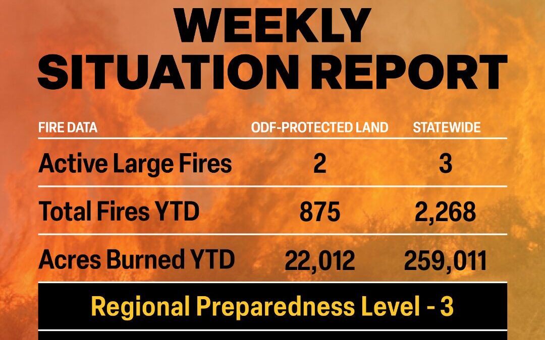
ODF Priority Fires
FIRE NAME
TOTAL ACRES
ODF ACRES
CONTAINMENT
LOCATION
COMMAND
Flat
23,346
8,442*
67%
7 miles W of Culver
ODF CIMT 3
Juniper Canyon
7,585
0
95%
12 miles NE of Hermiston
ODF ICT 4
*These numbers may change as we receive more data.
There are approximately 1,604 personnel assigned to the 3 large fires across the state, not including many of the local and agency government employees, landowners, forestland operators, and members of the community who are contributing every day.
Initial attack remains ODF’s top priority.
Weather: Fire conditions will remain elevated as hot, dry, and unstable weather continues. Near-record temperatures are likely through Friday, with the most critical burn environment from the Cascades eastward. Low humidity and poor overnight recovery will extend burn periods. The Coast Range and Olympics remain less affected but still see moderate ventilation potential. Mostly dry thunderstorms during the day will be focused over central and southern Oregon through Wednesday. Nocturnal dry storms remain possible nearly anywhere due to a complex upper-level pattern. Thunderstorm locations expand northward Thursday. While individually less intense, overall lightning counts and coverage increases. Cooler, showery weather is expected this weekend and early next week, though wet thunderstorm potential remains.
Prevention: The Oregon Department of Forestry reminds Oregonians that with weather fluctuating across the state, fire season is still in effect. The department warns the public against complacency until soaking, fall rains return.
Remaining informed of local fire restrictions is a simple way to prevent you from bringing prohibited fire hazards onto the landscape and from potentially starting the next large wildfire. Remember, the fewer human-caused fires in Oregon we have, the more you’re helping protect Oregon’s natural resources, communities, and firefighters. Find danger levels and restrictions across the state here.
ODF Highlight: Over the holiday weekend, the Oregon Department of Forestry’s Northeast Oregon District took command of the Juniper Canyon Fire in Umatilla County. This fire was unique in the fact that, though it was outside of ODF’s jurisdiction, the activation of Emergency Support Function (ESF) 4, allowed ODF to assume command. Prior to and after taking command, this fire was supported not just by ODF, but also by local landowners, local and state emergency services, and federal firefighting resources.
“This fire is a great example of strong partnerships. From the local farmers, landowners and emergency services to our federal partners, we were all working together to suppress the Juniper Canyon Fire as fast as possible while protecting nearby communities,” Justin Lauer, ODF Northeast Oregon District Forester, said.
The Juniper Canyon Fire showed the efficiency of the complete and coordinated fire system in Oregon and how we all have a part in protecting our communities and natural resources from wildfire.
SISTERS, Ore. (September 2, 2025) — The Flat Fire, approximately two miles northeast of Sisters, Oregon, is estimated at 23,346 acres and is 67% contained. Despite ongoing critical fire weather—including hot, dry conditions and a chance of thunderstorms—established fire lines continue to hold, and suppression repair work is progressing steadily across the incident area.
Today, crews will continue patrolling the fire perimeter to identify and extinguish any remaining heat and smoke. Suppression repair efforts to support recovery are also underway. These include repairing dozer lines and installing water bars to reduce erosion. Resources assigned to the Flat Fire remain ready to support the local district with initial attack response if new fires emerge. Firefighters are making consistent progress toward full containment.
Oregon Department of Forestry’s Complex Incident Management Team 3 (CIMT) is preparing to turn the Flat Fire back to the local district. Suppression efforts will continue with a smaller incident management organization. Tentative transfer of command is 7 a.m. Thursday, September 4.
Firefighter Safety: Today marks the first day of school in the area. Expect increased traffic in the morning and afternoon. Please adhere to posted speed limits, stay alert for children and school buses, and exercise caution near schools and bus stops.
We also remind the public to be aware of fire crews and equipment operating in and around the fire area. Please give crews the space they need to work safely
Wildfire Prevention: Hot temperatures and low humidity persist in the area, increasing fire risk and contributing to potential fire growth; Fire danger remains high. If you’re spending time outdoors, be vigilant and help prevent new fires by following all local regulations:
Evacuations: Evacuations are managed by the Deschutes County Sheriff’s Office and Jefferson County Sheriff’s Office.
Level 1 and 2 evacuations remain in effect under the direction of the Deschutes County Sheriff’s Office and the Jefferson County Sheriff’s Office. Follow their Facebook pages for the latest information and updates. They can also be reached by phone: Deschutes County Sheriff’s Office at (541) 388-6655, and Jefferson County Sheriff’s Office (541) 475-6520.
Local Area Closures: To support fire operations and firefighter safety, the Bureau of Land Management and U.S. Forest Service request that people stay out of the fire area.
The Prineville BLM has reduced the emergency closure on public lands around the fire. Steamboat Rock and Buckhorn OHV areas, as well as trails around Crooked River Ranch, including Steelhead Falls, are now open for public access.
Remaining closures can be found under the Prineville tab on the following page:
The U.S. Forest Service removed closures on the Deschutes National Forest.
As a reminder, drone use near fires is both illegal and extremely dangerous to pilots working on incidents. If you fly, we can’t. FAA Temporary Flight Restrictions are in place for the fire area. All illegal drone use will be reported to law enforcement.
GLENDALE, ORE: On Sunday, August 31, 2025, at approximately 9:00 pm., crews from the Douglas Forest Protective Association (DFPA), South Umpqua Fire, Riddle Fire, Azalea Fire, Glendale Fire, and Tri City Fire responded to a smoke investigation located near the 30400 block of Lower Cow Creek Road, outside of Glendale, Oregon.
Upon arrival at the scene, a fast-moving, wind-driven fire was found in reproduction timber and grass, climbing uphill to the north and down a drainage to the east. Crews responded immediately and are engaged in an aggressive initial attack. The fire’s current size is estimated at 130 acres.
DFPA’s night crews, which included four engines, four squads, two dozers, multiple firefighters, and overhead command, worked aggressively to establish both hand and dozer lines around the fire’s perimeter throughout the night. As of 0700 this morning, September 1, 2025, air resources have been deployed and are engaged in fire suppression tactics. Additional resources, including four tenders, two dozers, one tethered dozer, four 20-person crews, three helicopters, and two VLATs, have been ordered and are continuing to arrive at the scene.
Due to the proximity of the fire, in coordination with structural fire departments and the Douglas County Sheriff’s Office (DCSO), Level 1 evacuation orders, BE READY, have been issued for the following locations:
All addresses between 30482 – 31302 Lower Cow Creek Rd.
A LEVEL 1 – BE READY EVACUATION NOTICE means you should be aware of the danger that exists in the area, monitor emergency services websites and local media outlets for information. This is the time for preparation and precautionary movement of persons with special needs, mobile property, and (under certain circumstances) pets and livestock. If conditions worsen, emergency services personnel may contact you via an emergency notification system.
The cause of this fire is under active investigation.
We want to emphasize that it is crucial not to use Unmanned Aircraft Systems (UAS), or drones, over or near wildfires. Unauthorized drone flights pose serious risks to firefighters, public safety, and wildfire suppression efforts.
IF YOU FLY, WE CAN’T.
Flying UAS without permission over wildfires may violate federal, state, and local laws, regulations, and ordinances, regardless of whether a Temporary Flight Restriction (TFR) is in place.
Flying a drone near a wildfire is dangerous and can cost lives. When people fly drones near wildfires, fire response agencies often ground their aircraft to avoid the potential for a midair collision. Delaying airborne response poses a threat to firefighters on the ground, residents, and property in nearby communities, and it can allow wildfires to grow larger.
It’s a federal crime, punishable by up to 12 months in prison, to interfere with firefighting efforts on public lands. Additionally, the FAA can impose a civil penalty of up to $75,000 against any drone pilot who interferes with wildfire suppression, law enforcement, or emergency response operations when temporary flight restrictions (TFRs) are in place.
The FAA treats these violations seriously and immediately considers swift enforcement action for these offenses.
SISTERS, Ore. (September 1, 2025) — The Flat Fire, approximately two miles northeast of Sisters, Oregon, is estimated at 23,346 acres and is 52% contained. Despite critical fire weather, established fire lines have remained secure and suppression repair objectives continue across the incident. The Red Flag Warning is no longer in effect due to a lower chance of strong gusty winds. Hot, dry conditions persist.
Today, firefighters will focus on restoring areas impacted by fire response efforts, such as repairing dozer lines and reducing erosion risks. These initiatives strengthen containment and protect the landscape to support long-term recovery. With a unified mission across the fire line, crews continue to make steady progress, bringing the incident closer to full suppression.
Oregon State Fire Marshal (OSFM) resources have demobilized from the Flat Fire. Cooperative firefighting efforts from structural, wildland, and air resources protected homes through extreme fire activity and critical weather conditions. 17 OSFM task forces and strike teams, made up of 261 firefighters from all over Oregon, responded to help local agencies protect the community. Their efforts, in conjunction with the progress by wildland firefighters, have helped mitigate the risk to structures and allowed residents to safely return to their homes.
Wildland resources remain on the fire, continuing mop-up and are available to assist local resources if needed. OSFM is available to return if an imminent threat to structures exceeds capabilities of existing resources. OSFM would like to extend their appreciation to the local communities and agencies for their incredible support and cooperation throughout this challenging time.
“We are thankful for all the hard work firefighters have put in and hope everyone has a safe Labor Day,” says Eric Perkins, Deputy Incident Commander for Oregon Department of Forestry CIMT Team 3.
Firefighter Safety: We ask everyone to remain mindful that fire crews are still working in the area. Please drive carefully, watch for firefighting equipment on the roads, and allow crews space to do their jobs safely.
Wildfire Prevention: If your weekend plans take you outside, please be aware of the fire risks and recreate safely. Hot temperatures and low humidity persist in the area, increasing fire risk and contributing to potential fire growth; help prevent the next wildfire by following all local regulations:
Evacuations: Evacuations are managed by the Deschutes and Jefferson County Sheriff’s Offices.
Level 1 and 2 evacuations remain in effect under the direction of the Deschutes County Sheriff’s Office and the Jefferson County Sheriff’s Office. Follow their Facebook pages for the latest information and updates. They can also be reached by phone: Deschutes County Sheriff’s Office at (541) 388-6655, and Jefferson County Sheriff’s Office (541) 475-6520.
Local Area closures: To help fire operations and firefighter safety, the Bureau of Land Management and U.S. Forest Service ask that people stay out of the fire area.
The Prineville BLM reduced the emergency closure on public lands around the fire. Steamboat Rock and Buckhorn OHV areas, as well as trails around Crooked River Ranch like Steelhead Falls, are open again.
Remaining closures can be found under the Prineville tab on the following page:
The U.S. Forest Service removed closures on the Deschutes National Forest.
As a reminder, drone use near fires is both illegal and extremely dangerous to pilots working on incidents. If you fly, we can’t. FAA Temporary Flight Restrictions are in place for the fire area. All illegal drone use will be reported to law enforcement.
SISTERS, Ore. (August 31, 2025) — The Flat Fire, approximately two miles northeast of Sisters, Oregon, is estimated at 23,346 acres and is now 39% contained. Decreased acreage is a result of more accurate mapping of the fire footprint. After several days of challenging weather, established primary control lines have held strong. A Red Flag Warning is once again in effect for the fire area today due to high winds, as crews continue to focus on increasing containment.
Yesterday, crews utilized infrared cameras to detect and extinguish hot spots within the fire perimeter. On the southwestern side of the fire, resources worked to secure unburned vegetation inside the line, as suppression repair efforts progressed on the northern edge of the fire.
Today, resources will expand suppression repair work, flattening berms and diverting water off constructed dozer lines to decrease potential soil erosion. Firefighters will also be going door to door to assist landowners with land repair work if needed, as structural crews carefully check mop-up work near homes. Seamless integration between structural and wildland resources, and effective coordination between all agencies, has helped firefighters quickly meet incident objectives.
As conditions on the Flat Fire continue to stabilize, Oregon State Fire Marshal (OSFM) task forces are returning to their communities. Fire officials are confident in the progress made, allowing firefighters from Lincoln, Washington, and Lane Counties to be released today, with the remainder of OSFM resources returning to their home agencies tomorrow morning.
Firefighter Safety: As holiday weekend traffic increases, and more residents return to affected communities, we ask everyone to remain mindful that fire crews are still working in the area. Please drive carefully, watch for firefighting equipment on the roads, and allow crews space to do their jobs safely.
Wildfire Prevention: If your weekend plans take you outside, please be aware of the fire risks and recreate safely. Hot temperatures, low humidity, and gusty wind conditions persist in the area, naturally increasing fire risk and contributing to potential fire growth; help prevent the next wildfire by following all local regulations:
Evacuations: Evacuations are managed by the Deschutes County Sheriff’s Office and Jefferson County Sheriff’s Office.
Level 1 and 2 evacuations remain in effect under the direction of the Deschutes County Sheriff’s Office and the Jefferson County Sheriff’s Office. Follow their Facebook pages for the latest information and updates. They can also be reached by phone: Deschutes County Sheriff’s Office at (541) 388-6655, and Jefferson County Sheriff’s Office (541) 475-6520.
A 24-hour evacuation shelter has been set up by the Red Cross at Highland Baptist Church located at: 3100 SW Highland Ave, Redmond, OR. Jefferson County Fairgrounds in Madras and Kerley Horse Center in Powell Butte are available for large animals.
Local Area closures: To help fire operations and firefighter safety, the Bureau of Land Management and U.S. Forest Service ask that people stay out of the fire area.
The Prineville BLM has reduced the emergency closure on public lands around the fire. Steamboat Rock and Buckhorn OHV areas, as well as trails around Crooked River Ranch like Steelhead Falls, are open again.
The BLM has reduced closures, which can be found under the Prineville tab on the following page:
As a reminder, drone use near fires is both illegal and extremely dangerous to pilots working on incidents. If you fly, we can’t. FAA Temporary Flight Restrictions are in place for the fire area. All illegal drone use will be reported to law enforcement.