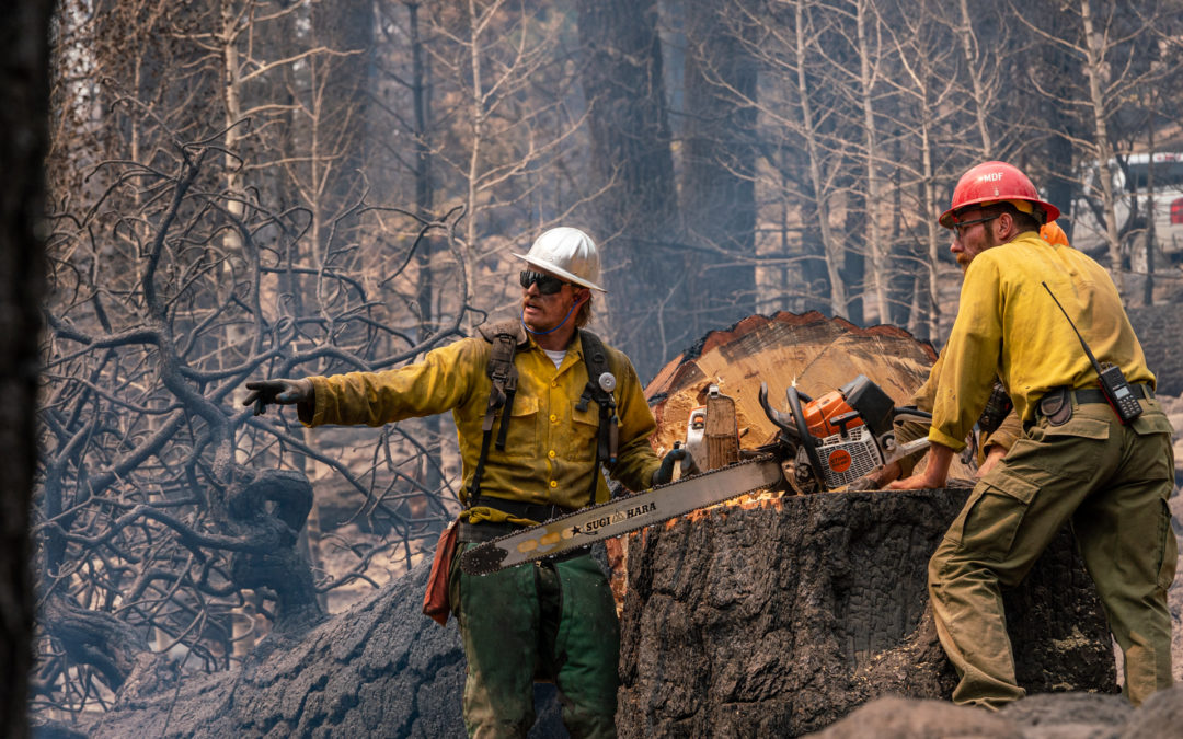
July 30, 2021
Location: 28 miles northeast of Klamath Falls, OR Size: 413,545 acres
Personnel: 1,928 Containment: 53%
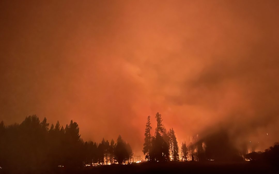
WALLOWA, Ore. – The water is flowing across all divisions of the Elbow Creek Fire 17 miles northwest of Wallowa. Fire crews have fully transitioned to mop-up and an increase in the number of water tenders will keep the water flowing to help firefighters soak the remains of the fire over the next several days.
The fire is 22,955 acres and 57% contained.
A 10-person crew made it halfway down over the rim yesterday towards the bottom of the Grande Ronde River Canyon in the Elbow Creek drainage. They will continue to the bottom of the canyon today to seek and destroy hot spots along the river.
The depth of mop-up, or how far crews should go in from the fire’s edge, is based on the fuels and the heat they hold. Grass for instance, doesn’t hold heat for very long, and poses less of a threat of tossing embers over containment lines in coming weeks. Whereas heavier fuels, such as downed logs and stumps, can hold heat for weeks and even months. Areas covered with heavier fuels may require up to 300 feet to assure no burning embers carried by winds over the line.
Contingency work continues on the north side of the fire with crews improving roads and removing roadside vegetation in the event a backup fire break be needed.
Today’s weather is expected to be mostly sunny, hot, and dry with areas of smoke and haze. The high will be 94-99 degrees, relative humidity 11-20 percent, and northeasterly afternoon winds from 8-12 mph with gusts to 18.
Evacuation levels within Wallowa County remain unchanged for now. Additional information on evacuation levels is available on the Wallowa County Sheriff’s Office Facebook page (www.facebook.com/Wallowa-County-Sheriffs-Office-147212815486187).
Evacuations: Evacuations are dynamic. Klamath County has dropped all evacuation notices; however, the Fremont-Winema National Forest remains closed. Evacuation levels were lowered in Lake County. The best way to view the evacuation designation boundaries and details is on the interactive map available at tinyurl.com/bootlegevac
Red Cross Evacuation Shelters: For information or assistance: 1-800-Red-Cross (www.redcrossblog.org/disaster)
Insurance Assistance: For additional information on submitting insurance claims after losing your home or property to a wildfire, please visit https://dfr.oregon.gov/insure/home/storm/Pages/wildfires.aspx or call the state’s team of consumer advocates at 888-877-4894 (toll-free).
Closures: The Fremont-Winema National Forest is closed to the public in the fire area. The full closure order and map are available at https://www.fs.usda.gov/alerts/fremont-winema/alerts-notices
Smoke: Smoke from the Dixie Fire in Northern California could once again affect the southern part of the region today. The Bootleg and other nearby fires, including the Jack Fire just to the northwest of the region, continue to impact air quality on our region. Today, we will see another good to moderate day of air quality. Periods of moderate air quality will be brief. See: fires.airfire.org/outlooks/southcentraloregon
Fire Information Public Phone: 541-482-1331 Fire Information Media Phone: 971-727-7255
Inciweb: inciweb.nwcg.gov/incident/7609/ Facebook: www.facebook.com/BootlegFireInfo
Twitter: twitter.com/BootlegFireInfo Hashtags: #BootlegFire #FireYear2021
July 30, 2021
WALLOWA, Ore. – The water is flowing across all divisions of the Elbow Creek Fire 17 miles northwest of Wallowa. Fire crews have fully transitioned to mop-up and an increase in the number of water tenders will keep the water flowing to help firefighters soak the remains of the fire over the next several days.
The fire is 22,955 acres and 57% contained.
A 10-person crew made it halfway down over the rim yesterday towards the bottom of the Grande Ronde River Canyon in the Elbow Creek drainage. They will continue to the bottom of the canyon today to seek and destroy hot spots along the river.
The depth of mop-up, or how far crews should go in from the fire’s edge, is based on the fuels and the heat they hold. Grass for instance, doesn’t hold heat for very long, and poses less of a threat of tossing embers over containment lines in coming weeks. Whereas heavier fuels, such as downed logs and stumps, can hold heat for weeks and even months. Areas covered with heavier fuels may require up to 300 feet to assure no burning embers carried by winds over the line.
Contingency work continues on the north side of the fire with crews improving roads and removing roadside vegetation in the event a backup fire break be needed.
Today’s weather is expected to be mostly sunny, hot, and dry with areas of smoke and haze. The high will be 94-99 degrees, relative humidity 11-20 percent, and northeasterly afternoon winds from 8-12 mph with gusts to 18.
Evacuation levels within Wallowa County remain unchanged for now. Additional information on evacuation levels is available on the Wallowa County Sheriff’s Office Facebook page (www.facebook.com/Wallowa-County-Sheriffs-Office-147212815486187).
July 29, 2021
Location: 28 miles northeast of Klamath Falls, OR Size: 413,545 acres
Personnel: 1,994
Size: 413,545 acres
Personnel: 1,994
Containment: 53%
KLAMATH FALLS, Ore. – Despite the recent rain, fire activity picked up yesterday. Fire Behavior Specialist Chris Moore commented on how unusual it is to see fire flare ups so quickly after a wetting rain. “As we move out of normal climatological range, previous experience is less relevant,” said Moore. “The rain that we got will not put the fire out. Spotting will become more of an issue as fuels dry out again.” Incident Commander Norm McDonald reinforced this caution stating that we need “a recalibration of where we are. There isn’t a ‘normal’ anymore. We need to be prepared for anything.”
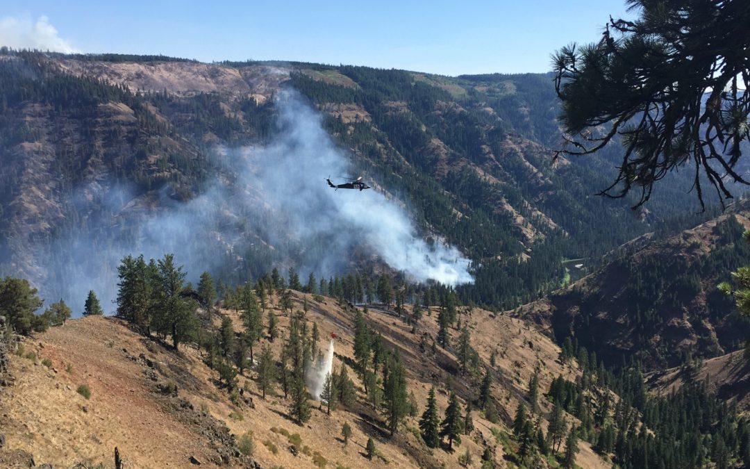
Fire activity increased as the warm day dried out the fire faster and wind gusts were stronger than expected. The northwest corner remains the most active area. Dozers and hand crews are working together to close the line around that portion of the perimeter. Heavy helicopter support kept the fire cool while crews worked around Round Butte. The objective today is to hold and secure the progress made.
Two more ember-cast spot fires were identified yesterday off the northeast flank of the fire, west of Winter Rim. The spot fires were about a half mile outside the fire perimeter and small in size (less than two acres). Helicopters dropped water as air tankers made multiple retardant drops. It still requires firefighters working on the line to secure these spots. Crews will continue to take aggressive action to address any future spot fires.
The east flank of the fire remains active. That edge of the fire is a “dirty edge,” that is, there isn’t a continuous edge to the fire in this area as the fire leaves pockets of unburned vegetation. This ragged edge is more difficult for crews to secure.
In the southern portion of the fire, where activity has been relatively quiet, there were flare ups and smoke plumes visible yesterday from inside the burned area. This is a good thing. Burning fuels within the fire perimeter will help decrease the heat and chances for ember cast in the future.
Warm weather will continue through the week. Gusty winds are expected today, especially in more open areas. Yesterday a Fire Weather Watch was issued for much of the fire area through Friday. West of the fire, a Red Flag Warning is in effect through tomorrow due to thunderstorms. Scattered rain and isolated thunderstorms are possible through the weekend. More information available at https://inciweb.nwcg.gov/incident/article/7609/62198/
Evacuations: Evacuations are dynamic. Klamath County has dropped all evacuation notices; however, the Fremont-Winema National Forest remains closed. Evacuation levels are being lowered again in Lake County. The Lake County Sheriff’s Office and Emergency Management are removing all residences in Lake County outside of the fire’s perimeter from a Level 3 evacuation. Effective immediately. The best way to view the evacuation designation boundaries and details is on the interactive map available at tinyurl.com/bootlegevac
Red Cross Evacuation Shelters: For information or assistance: 1-800-Red-Cross (www.redcrossblog.org/disaster) Insurance Assistance: For additional information on submitting insurance claims after losing your home or property to a wildfire, please visit https://dfr.oregon.gov/insure/home/storm/Pages/wildfires.aspx or call the state’s team of consumer advocates at 888-877-4894 (toll-free).
Closures: The Fremont-Winema National Forest is closed to the public in the fire area. The full closure order and map are available at https://www.fs.usda.gov/alerts/fremont-winema/alerts-notices Smoke: Winds out of the southwest could blow smoke over the eastern parts of the region. The communities of Silver Lake and Paisley could see elevated air quality today. There is a chance that Silver Lake could see some of the heaviest impacts. See: fires.airfire.org/outlooks/southcentraloregon
Fire Information Public Phone: 541-482-1331
Fire Information Media Phone: 971-727-7255
Inciweb: inciweb.nwcg.gov/incident/7609/ Facebook: www.facebook.com/BootlegFireInfo
Twitter: twitter.com/BootlegFireInfo
Hashtags: #BootlegFire #FireYear2021
July 29, 2021
WALLOWA, Ore. – With fire activity diminishing and the focus moving to full mop-up operations, Oregon Department of Forestry’s Incident Management Team 3 is starting to “right-size” the organization on the Elbow Creek Fire. Operations’ Section Chief Eric Perkins says that will begin with sending some aircraft to either their home base or to other fires with a greater need.
The Elbow Creek Fire is approximately 22,955 acres and 50 percent contained.
Crews continued grid searching the east side of Elbow Creek for spot fires. After several days of tracking down numerous spot fires in the area, no new spots were discovered. Gridding and mopping up will continue.
Crews went direct on the fire line in Duckworth drainage, and the few spot fires discovered in the south and southwest area of the fire were mopped up 100%. Most of north and east perimeter of the fire are in full mop-up mode with continued use of handheld infrared heat detection devices.
Contingency work continues on the north side of the fire with crews improving roads and removing vegetation along these roads in the event a backup fire break be needed. Personnel on the incident number 1,015, with 34 engines, 11 dozers, 22 water tenders and 38 other heavy equipment.
There have been seven reportable illnesses/accidents on the incident to date; all of which were categorized as minor. One of the seven occurred yesterday which was an illness from a prior existing condition.
Today’s weather is expected to be mostly sunny with little smoke and haze. The high will be 90-95 degrees, relative humidity 15 to 25 percent, and southwesterly afternoon winds from 3 to 7 mph with gusts to 14.
Evacuation levels within Wallowa County remain unchanged for now. Additional information on evacuation levels is available on the Wallowa County Sheriff’s Office Facebook page (www.facebook.com/Wallowa-County-Sheriffs-Office-147212815486187).
# # #
July 28, 2021
WALLOWA, Ore. – The Elbow Creek Fire is approximately 22,901 acres and 43 percent contained. Firefighting personnel and equipment continue to arrive, filling most fire line resource needs.
Crews continued with burnouts in the east side of Elbow Creek and working grids to locate and suppress any spot fires in the area. Work by firefighters is now transitioning to mop up and patrol along all Divisions, while ongoing work continues on known, scattered hot areas such as those discovered in dozer berms along fire lines.
Aiding in this work is use of handheld infrared heat detection cameras to locate hot spots not readily visible.
Besides risks normally thought of with regard to firefighting, other environmental risks are showing up with more frequency now, specifically stinging insects and poisonous snakes.
Strict COVID precautions are being observed within the Incident Command Center and the Fire Camp, not only to reduce risk to firefighters, but also to the community.
Very light rain occurred over portions of the fire area last night with no significant, long term effect to burning conditions. Lightning did occur broadly over the region last night with none observed in the fire vicinity. Today’s weather is expected to be mostly cloudy with some smoke and haze, and a slight chance of showers and thunderstorms. Temperatures will be slightly warmer with highs between 87 and 93 degrees, and relative humidity from 15 to 25 percent. Afternoon winds will be from the southwest at 3 to 7 miles per hour with gusts to 15.
Evacuation levels within Wallowa County remain unchanged for now. Additional information on evacuation levels is available on the Wallowa County Sheriff’s Office Facebook page (www.facebook.com/Wallowa-County-Sheriffs-Office-147212815486187
July 28, 2021
Location: 28 miles NE of Klamath Falls
Size: 413,400 acres
Personnel: 1,924
Containment: 53%
KLAMATH FALLS, Ore. -– The west side of the fire received steady, light rain that allowed more direct attack on the fire’s edge yesterday and overnight. The rain significantly moderated fire behavior. Fine fuels are most affected by the moisture, although larger diameter fuels are still critically dry. Some isolated torching occurred yesterday in heavy fuels, but spotting was much reduced.
On the east side of the fire, crews continued to mop up after the spot fire from yesterday. With the added moisture they have no concerns about that area today. The Oregon National Guard crews are working on the east flank of the fire area to secure the perimeter and put out any hot spots. Crews are completjng lines on the fire perimeter near the Old Trunk road around the burned area of the 2018 Watson Creek Fire.
Along the Sycan River there is still active fire in the treed riparian area, but the wetter areas of the Sycan Marsh will likely remain unburned. The southern and western portions of the fire have shown little fire activity and remain in monitor and patrol status.
“The cooler temperatures and precipitation yesterday were a welcome change,” said Incident Meteorologist Chris Foltz. “A wetting rain fell yesterday dropping as much as 0.6 of an inch on the western area of the fire. The eastern side was a bit drier, but still received a tenth of an inch. Not all areas of the fire received rain, but overall the cooler, more humid conditions are beneficial for the firefighting crews.”
The rain and cloud cover kept humidity levels above 60%. The rain tapered off overnight, although isolated thunderstorms are still possible, especially in the northwest region, over the next few days. Warmer temperatures will return and humidity will decrease starting today and over the next few days, so crews are watching for increased fire activity.
Evacuations: Evacuations are dynamic. Klamath County has dropped all evacuation notices; however, the Fremont-Winema National Forest remains closed. Lake County released an announcement of lowered evacuation levels. The most effective way to view the new designation boundaries is on the interactive map available at tinyurl.com/bootlegevac
Red Cross Evacuation Shelters: For information or assistance: 1-800-Red-Cross (www.redcrossblog.org/disaster)
Insurance Assistance: For additional information on submiting insurance claims after losing your home or property to a wildfire, please visit htps://dfr.oregon.gov/insure/home/storm/Pages/wildfires.aspx or call the state’s team of consumer advocates at 888-877-4894 (toll-free).
Closures: The Fremont-Winema National Forest is closed to the public in the fire area. The full closure order and map are available at htps://www.fs.usda.gov/alerts/fremont-winema/alerts-notices.
Smoke: Yesterday’s rainfall helped mitigate some of the smoke. Drier conditions are forecast to return today. Overall, air quality will remain generally good to moderate. Klamath Falls and Paisley are the exceptions; Klamath Falls could see periods of USG air quality, and Paisley could see periods as high as Unhealthy today. See: fires.airfire.org/outlooks/southcentraloregon.
Fire Information Public Phone: 541-482-1331
Fire Information Media Phone: 971-727-7255
Inciweb: inciweb.nwcg.gov/incident/7609/
Facebook: www.facebook.com/BootlegFireInfo
Twitter: twitter.com/BootlegFireInfo
Hashtags: #BootlegFire #FireYear2021
July 27, 2021
Fire size as of 7/25/21 Infrared Flight: 22,790 acres
Current fire containment: 38%
NORTHEAST OREGON — Monday night was relatively calm for operations as crews continued to take the heat out of the the Elbow Creek Fire. Fire tactics on the north side of the Grande Ronde River included mopping up spot fires east of Elbow Creek and monitoring the burnout in the eastern portion of the drainage. In the northeast corner, eight minor spot fires were caught and contained. On the south side, crews continued to mop-up and work on strengthening lines around Sickfoot Creek.
For today, a contingency group will continue to prepare roads on the north side of the river. On the south side, crews will secure problem areas and make the edge more secure around Duckworth Creek. Mop-up efforts deeper into the fire perimeter will continue on both sides of the river.
The northeast and southwest sides of the fire have been caught, remain stable, and are being mopped up deeper into the fire perimeter, as much as 200 feet in most areas.
Hot and dry weather conditions remain, but today we will see some slight changes in the weather patterns. A southerly flow will be bringing in monsoon moisture and more clouds. There is a slight chance for showers and thunderstorms.
The Umatilla National Forest remains closed as well as several roads within the fire area.
# # #
July 27, 2021
Location: 28 miles northeast of Klamath Falls
Size: 410,731 acres
Personnel: 2,099
Containment: 53%
KLAMATH FALLS, Ore. – This morning the Alaska Incident Management Team assumed leadership of the Bootleg Fire after several days of transition with the other teams.
Incident Commander Norm McDonald thanked the Pacific Northwest Team 2, Oregon State Fire Marshal Red Team, and Oregon Department of Forestry Team 1 for leaving us in such a good position. “We will continue operations with a focus on the safety of the community and our firefighters,” said Commander McDonald. “We’re continuing with community and agency partners to suppress the fire as effectively as possible to protect timber, ranchlands, and other local values.”
As of yesterday, the southern boundary line continued to hold; this area remains in patrol status. Operations focus on eliminating remaining hot spots and burning out fuel pockets to widen the perimeter and secure the fire’s edges.
Rugged terrain on the northwest side of the fire makes suppression slow going. There is a concentration of snags, downed logs, and slash that provide heavy fuels to the fire. And while progress is being made, this area continues to be a challenge. Favorable weather today will create a good window for direct attack.
On the northeast side, crews extinguished a small spot fire of less than 3 acres that jumped the perimeter. With the changing weather conditions, spotting potential should decrease today, but crews will remain vigilant and respond quickly to threats as they arise.
Temperatures are expected to cool today with an increase in humidity and likelihood of isolated showers continuing through tomorrow. The mild weather will have a short-term calming effect on the fire behavior. But due to the extremely dry conditions and fuels, as the week progresses and temperatures rise, aggressive fire behavior is likely to quickly rebound.
Yesterday, a thorough damage assessment was finalized that tallied the number of buildings damaged and destroyed in Klamath and Lake counties. This fire has a very large footprint and it is important to fire managers that the impact to people’s homes and other structures be accurately examined and counted. Surveying experts were able to safely access remote areas where the fire has caused significant damage and provide updated reporting to fire managers. In total, 161 residences were destroyed and 247 outbuildings. In addition, 342 vehicles were destroyed in the fire. These numbers may increase as firefighters and surveyors continue to work through the interior of the fire. For additional information on submitting insurance claims after a wildfire, please visit https://dfr.oregon.gov/insure/home/storm/Pages/wildfires.aspx or call the state’s team of consumer advocates at 888-877-4894 (toll-free).
Evacuations: Evacuations are dynamic. An interactive map of evacuation levels in Lake and Klamath Counties is available at tinyurl.com/bootlegevac
Red Cross Evacuation Shelters: For information or assistance: 1-800-Red-Cross (www.redcrossblog.org/disaster)
Closures: The Fremont-Winema National Forest is closed to the public in the fire area. The full closure order and map are available at https://www.fs.usda.gov/alerts/fremont-winema/alerts-notices.
Smoke: Lower air pressure is expected today, meaning the atmosphere itself will be a little more unstable. The more unstable the atmosphere, the easier it is for air and smoke to rise. There shouldn’t be as much smoke on the ground as there has been over the past several days. This is reflected in today’s forecast, as a lot of sites should see generally good air quality today. Pockets of moderate air quality will be possible throughout the day. See: fires.airfire.org/outlooks/southcentraloregon.
Bootleg Fire Information
Email: bootleg.fire.information@gmail.com
Public Line: 541-482-1331
Media Line: 971-727-7255
Inciweb: inciweb.nwcg.gov/incident/7609/
Facebook: www.facebook.com/BootlegFireInfo
Twitter: twitter.com/BootlegFireInfo
July 27, 2021
National: Preparedness Level 5 (Geographic areas competing for wildland fire suppression resources. Majority of national resources committed. Three or more geographic areas with large, complex fires.)
|
Number of fires |
Acres burned |
| Total to date |
36,796 |
2,823,453 |
Oregon: Preparedness Level 5.
| Only ODF-protected lands (16 million acres) |
|
|
| |
Number of fires |
Acres burned |
| 2021 year-to-date |
631 |
176,842 |
| 10-year avg. year-to-date (2011 – 2020) |
452 |
19,534 |
| All lands in Oregon (Includes ODF-protected lands) |
|
| |
Number of fires |
|
Acres burned |
| 2021 year-to-date |
1,075 |
|
498,974 |
Current large fires in Oregon: Includes all lands
| Name |
Date |
Total Acres |
ODF
Acres |
Containment |
Location |
Cause |
Notes |
| Bootleg |
July 6,
2021 |
410,731 |
152,360 |
53% |
28 miles NE of Klamath Falls |
Lightning |
AK IMT 1, &
OSFM Red IMT
Fire information |
| Due to cooler weather and significantly higher RH, evacuation levels were reduced in the Paisley and Summer Lake areas; evac levels may be reduced further over the next couple of days, weather permitting. The NW and NE flanks continue to be resistant to control, with spotting and slopovers. Some logistical shortages are stalling plans to move some crews to an operational base closer to the fire edge. ODF IMT 1 is heading home today (yay!). |
| Jack |
July 5,
2021 |
21,881 |
81 |
59% |
20 M East of Glide |
Unknown |
NW IMT 10
Fire information |
| Crews continue working to secure the south flank of fire in the Twin Lakes area. Firing operations have taken place to remove fuel between fire edge and indirect segments of fire line. Mop up and equipment backhaul operations continue along the other flanks of the fire. Evacuation levels and area closures unchanged. |
| Bruler |
July 12, 2021 |
195 |
0 |
53% |
9 miles south of Detroit |
Unknown |
NW IMT 13
Fire information |
| Much of the indirect fire line has been tightened to be direct line. Mop up and alternative contingency fire line construction operations continue. A Type 3 IMT will take over the fire on Wednesday. |
| Elbow Creek |
July 15, 2021 |
22,790 |
14,445 |
38% |
31 miles SE of Walla Walla WA |
Unknown |
ODF IMT 3 Fire information |
| The last stretch of critical burnout was completed yesterday, and the black line around the fire is nearly finished. |
| Game Hog Creek |
July 13, 2021 |
182 |
182 |
90% |
22 miles NW of Forest Grove |
Unknown |
ODF Type 3 IMT |
| Fire line is complete. Resources are being scaled back this week. |
|
|
|
Oregon State Fire Marshal Conflagration Report |
| Conflagration Name |
Date Began |
Structures Threatened/Destroyed |
Status |
| Wrentham Market Fire |
6/30/2021 |
|
Demobed |
| Sunset Valley Fire |
7/1/2021 |
|
Demobed |
| Jack Fire |
7/6/2021 |
|
Demobed |
| Bootleg Fire |
7/7/2021 |
2,066 threatened/ 408 destroyed |
IMT and Agency Admin on scene & resources on scene |
| Grandview Fire |
7/12/2021 |
|
Demobed |
| Elbow Creek Fire |
7/16/2021 |
6 destroyed |
Demobed |
| Totals |
|
2,066 threatened/ 414 destroyed |
|
More information:
- Monsoonal moisture brought overnight showers and some lightning to SWO and S/Central Oregon. Showers and isolated lightning likely today in S/Central and Eastern Oregon.
- A surge package of five IHC crews and one Type 2 crew is being assembled for staging in PNW.
Resources:
July 26, 2021
Full size resolution ODF/OSFM fire situation report map
National: Preparedness Level 5 (Geographic areas competing for wildland fire suppression resources. Majority of national resources committed. Three or more geographic areas with large, complex fires.)
|
Number of fires |
Acres burned |
| Total to date |
36,610 |
2,797,026 |
Oregon: Preparedness Level 5.
| Only ODF-protected lands (16 million acres) |
| |
Number of fires |
Acres burned |
| 2021 year-to-date |
625 |
176,327 |
| 10-year avg. year-to-date
(2011 – 2020) |
444 |
19,526 |
| All lands in Oregon (Includes ODF-protected lands) |
| |
Number of fires |
Acres burned |
| 2021 year-to-date |
1,062 |
495,407 |
Current large fires in Oregon: Includes all lands
| Name |
Date |
Total Acres |
ODF Acres |
Containment |
Location |
Cause |
Notes |
| Bootleg |
July 6, 2021 |
409,611 |
151,658 |
53% |
28 miles NE of Klamath Falls |
Lightning |
ODF IMT 1, PNW IMT 2, & OSFM Red IMT
Fire information |
| Lightning overnight caused one small fire off SE flank that was attacked by IA resources from Bootleg. The E flank is holding above Winter Rim, and indirect fire line construction off the N flank is to protect Summer Lake area. Crews on W flank continue to patrol and mop up. PNW IMT 2 demobilizes today, and ODF’s IMT 1 will transfer command tomorrow to a Type 1 IMT from Alaska. |
| Jack |
July 5, 2021 |
21,250 |
81 |
58% |
20 M East of Glide |
Unknown |
NW IMT 10
Fire information |
| Work continues on the fire’s SE flank where torching, spot fires and slopovers continue near the Twin Lakes area. Surge resources are helping with fire line construction and burnout operations. Crews on N flank patrol and mop up. |
| Bruler |
July 12, 2021 |
195 |
0 |
47% |
9 miles south of Detroit |
Unknown |
NW IMT 13
Fire information |
| Mop up and contingency fire line construction operations continue. Expect transfer to Type 3 IMT on Wednesday. |
| Elbow Creek |
July 15, 2021 |
22,681 |
14,076 |
32% |
31 miles SE of Walla Walla WA |
Unknown |
ODF IMT 3
Fire information |
| Much of fire is lined and heavy mop-up is underway. Spotting continues to be a problem in Elbow Creek drainage. Resource sharing continues with Lick Creek and Green Ridge fires, located across the Washington border. |
| Game Hog Creek |
July 13, 2021 |
182 |
182 |
0% |
22 miles NW of Forest Grove |
Unknown |
ODF Type 3 IMT |
| Patrol and monitoring. |
| Oregon State Fire Marshal Conflagration Report |
|
| Conflagration Name |
Date Began |
Structures Threatened/Destroyed |
Status |
| Wrentham Market Fire |
6/30/2021 |
|
Demobed |
| Sunset Valley Fire |
7/1/2021 |
|
Demobed |
| Jack Fire |
7/6/2021 |
|
Demobed |
| Bootleg Fire |
7/7/2021 |
2,567 threatened/
184 destroyed |
IMT and Agency Admin on scene & resources on scene |
| Grandview Fire |
7/12/2021 |
|
Demobed |
| Elbow Creek Fire |
7/16/2021 |
81 threatened/
6 destroyed |
Demobed |
| Totals |
|
2,648 threatened/
190 destroyed |
|
More information
- Thunderstorms and lightning strikes occurred overnight around the Bootleg Fire and up through NE Oregon. Thunderstorms are predicted to stay in the region, primarily east of the Cascades, for much of the week. Storms may also develop in SWO today into Tuesday.
- Several IMTs have reported cases of COVID-19, followed by testing and quarantining of personnel as needed.
Resources:
July 26, 2021
Elbow Creek Fire is hosting another virtual community update tonight at 7 p.m.
Elbow Creek Fire update video: https://youtu.be/CLMx44hwj24
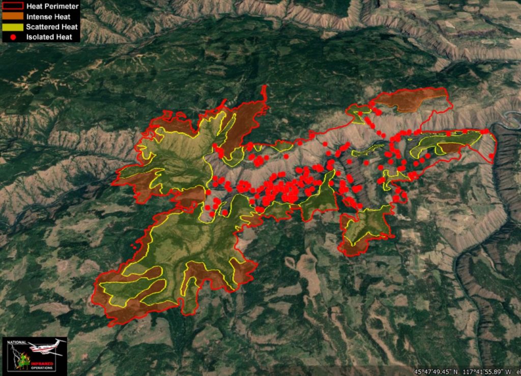
CURRENT FIRE SIZE AS OF 7/25/21 IR FLIGHT: 22,681 ACRES
CURRENT FIRE CONTAINMENT: 32%
Operations Section Chief praised crews at this morning’s Elbow Creek Fire briefing for the excellent work that has been done to date. Much of the fire is lined and crews are transitioning to heavy mop-up in most areas.
LAST NIGHT AND TODAY:
Last night, crews successfully wrapped up a burnout operation and finished tying together containment lines east of the 6212 Road in the Elbow Creek area. The area still showed increased fire activity with the fire spotting over containment lines throughout the late afternoon. However, crews were able to quickly respond and control all spot fires outside containment lines. Today, crews will prioritize this area and continue to focus efforts here.
Weather patterns consistent with the past few days have been forecasted for today’s operational period. This is good news – minimal winds, and slightly cooler temperatures reducing potential for extreme fire activity. Relative humidity will remain quite low though, around 13 to 24 percent.
Early in the evening yesterday, a firefighter did experience a burn injury to their hand and lower arm. The individual was transported to a La Grande hospital for evaluation and treatment and later released. To mitigate some of these potential risks, safety officers have asked all fire line personnel to implement 5 at 2, where they will take a tactical pause for 5 minutes at 2:00 p.m. and 2:00 a.m. to check in with their situational awareness.
Big Hole Spike camp will be fully moved into Elgin by this evening.
Elbow Creek Fire Information: 541-805-2784 (7 a.m. – 9 p.m.)
Email: elbowcreek.information@gmail.com
Facebook: www.facebook.com/ElbowCreekFire
Inciweb: inciweb.nwcg.gov/incident/7672/
July 26, 2021
Location: 28 miles northeast of Klamath Falls, OR
Size: 409,611 acres
Personnel: 2,257
Containment: 53%
Klamath Falls, ORE. – As firefighters successfully patrol and hold the containment line around the southern area of the Bootleg Fire, activity continues on the northern edges. Along the northwest perimeter of the fire, crews have been building indirect line utilizing forest roads from Coyote Creek, north to Round Butte. A burnout operation was conducted overnight to remove fuels ahead of the fire to stop its spread into timber stands.
“The challenge today,” said Pacific Northwest Team 2 Operations Chief Kyle Cannon, “is to secure the northernmost section of the fire north of Round Butte to the west side of 27 Road.”
On the northeast side, last night’s efforts focused again on the active fire along the Sycan River. Crews there are working to keep the fire off Winter Rim and from moving toward Summer Lake. Contingency line construction and structure protection continue around Summer Lake and Paisley. Incident managers are optimistic about the effectiveness of these efforts, but threats remain and evacuation levels have not yet changed. They encourage people to remain vigilant and updated on conditions.
Along the southern border, crews continue to progress deeper into the burned area extinguishing hot spots. This will further secure the fire’s edge. Firefighters have made excellent progress, with 98 miles of completed fire line in this zone. As they continue to patrol, any areas of remaining heat that could pose a future threat to the containment line will be extinguished.
Over the course of the fire, more than 90 fire departments from across the country have responded to the fire to serve the impacted communities. Today, an additional 120 Oregon National Guardsmen are arriving—six crews of 20—to join the firefighting force.
Weather and smoke conditions are improving over the next few days. Last night’s light, favorable winds from the north facilitated night operations. Although rainfall is rare this time of year, today thunderstorms are expected to roll in and produce rain tonight and tomorrow. While there is a danger of lightning, the rainfall, higher humidity, and cooler temperatures overall will assist firefighting efforts. Air quality has also eased across the state with most monitoring stations recording good to moderate air quality.
Did you miss the community meeting yesterday? You can check out the recording on the Bootleg Fire Facebook page or Twitter account for recent updates.
Evacuations: Evacuations are dynamic. An interactive map of evacuation levels in Lake and Klamath Counties is available at tinyurl.com/bootlegevac
Red Cross Evacuation Shelters: For information or assistance: 1-800-Red-Cross, (www.redcrossblog.org/disaster)
Closures: The Fremont-Winema National Forest is closed to the public in the fire area. Map and full order available at inciweb.nwcg.gov/incident/7609/.
Smoke: Weakening high pressure means that there will be less smoke on the ground today than in the past couple days. There could be times where air quality could reach the Unhealthy for Sensitive Groups (USG) level, but not for any extended period of time and will likely be more sporadic. Today’s forecast calls for mostly moderate air quality around the region, with conditions slowly improving overnight as the atmosphere becomes a bit more unstable, meaning air and smoke will be able to rise more easily compared to the past several days. See: fires.airfire.org/outlooks/southcentraloregon.
Bootleg Fire Information
Zone 1 Email: bootleg.fire.information@gmail.com
Zone 2 Email: 2021.bootleg@firenet.gov
Public Line: 541-482-1331
Media Line: 971-727-7255
Inciweb: inciweb.nwcg.gov/incident/7609/
Facebook: www.facebook.com/BootlegFireInfo
Twitter: twitter.com/BootlegFireInfo
July 26, 2021
JACKSON & JOSEPHINE COUNTIES, ORE. – Increased fire danger on forestlands protected by the Oregon Department of Forestry’s Southwest Oregon District has made it necessary to increase the fire prevention measures on industrial operations, such as logging sites and other commercial operations. Industrial Fire Precaution Level III (IFPL 3) takes effect Wednesday, July 28, 2021 at 12:01 a.m. This regulation increase impacts industrial operations in Jackson and Josephine counties only.
For the general public, ODF Southwest’s fire restrictions remain in effect and unchanged with a fire danger level of “extreme” (red).
Under IFPL III, the following are prohibited between 1:00 p.m. – 8:00 p.m.:
- Power saws at loading sites;
- Loading or hauling of any product or material;
- Blasting;
- Welding, cutting, or grinding of metal;
- Any other spark emitting operation not specifically
In addition, the following are permitted to operate overnight to the morning, between the hours of 8:00 p.m. and 1:00 p.m., where mechanized equipment capable of constructing fire line is immediately available to quickly reach and effectively attack a fire start:
- Ground-based operations (tractor/skidder, feller-buncher, forwarder, or shovel logging operations);
- Power saws on ground-based operations;
- Rotary head saw feller-bunchers with a continuous Firewatch;
- Non-rotary head saw feller-bunchers;
- Tethered logging – winch-assisted, cable-assisted, traction-assisted, etc. systems, which enable ground- based timber harvesting machines to operate on steep slopes
This is considered a restricted shutdown and the following activities are not permitted at any time, except as noted:
- Cable yarding systems, except that gravity operated logging systems using non-motorized carriages or approved motorized carriages may operate between 8:00 p.m. and 1:00 p.m., when all blocks and moving lines are suspended at least 10 feet above the ground (except the line between the carriage and the chokers).
For more information about the Oregon Department of Forestry’s fire season public and industrial restrictions, visit our website, www.swofire.com, our Facebook page @ODF Southwest Oregon District, or call the Southwest Oregon District unit office nearest to you:
- Medford Unit, 5286 Table Rock Rd., Central Point | (541) 664-3328
- Grants Pass Unit, 5375 Monument Dr., Grants Pass | (541) 474-3152
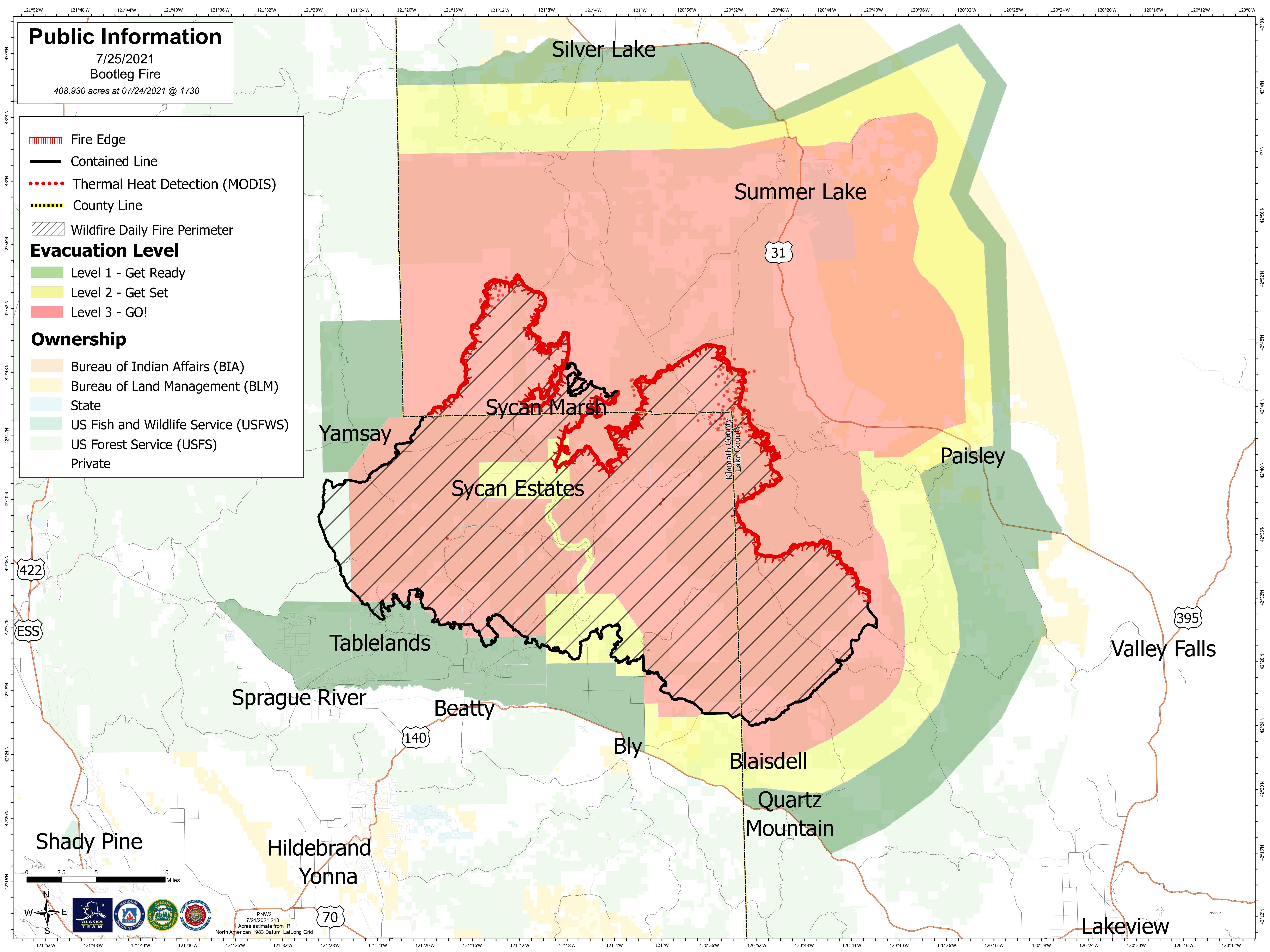
July 25, 2021
Full size resolution Bootleg Fire perimeter map.
Community Meeting: A virtual community meeting will be held on Facebook at 2:00 p.m. today. Join us online @bootlegfireinfo or members of the community of Paisley can watch the broadcast at the community center.
Location: 28 miles northeast of Klamath Falls, OR
Size: 408,930 acres
Personnel: 2,216
Containment: 46%
Klamath Falls, ORE. – Yesterday, firefighters held the fire in check above Winter Rim, aided by the recent burnout operation near Summer Lake. Crews will continue to mop-up and look for areas to engage the fire to keep it east of the 36 Road. The night shift constructed indirect line from the 28 Road to Sycan River and prepared for a possible future burnout operation to prevent northern movement of the fire in that area. Contingency lines and structure protection continue to be improved around Summer Lake and Paisley. The fire remains active in Coyote Creek drainage to the north, crews will scout opportunities to tie the fireline from Coyote Creek into the 400 Road and prepare for a possible burnout operation.
“The progress that we have made is due to the continuous, vigilant work by our crews,” said Joe Hessel, Incident Commander for the Oregon Department of Forestry Incident Management Team. “Severe fire weather conditions and extremely dry fuels continue to challenge us on this fire.”
Containment lines on the eastern side of the fire continue to be improved by removing smoldering fuels from the fire’s edge. Crews use visual signs during the day to find these areas of smoke. During night operations, firefighters use maps from infrared flights to track down potential sources of heat.
On the west side of the fire, containment lines continue to hold and are being patrolled. Fire managers are preparing for suppression repair work to begin to mitigate the impacts of firefighting efforts on the landscape. The Oregon National Guard will join forces with firefighters in this important work.
Firefighters from this fire may be called to provide initial attack response to new fire starts that have the potential to rapidly grow, given the extremely dry fuel conditions.
As the smoke lifts today, fire behavior is expected to pick up in the afternoon. Today will be the warmest and driest for the next several days. Winds are forecast to become increasingly northwesterly throughout the day but remain light. Vertical column development should remain limited by smoke impacts from nearby fires. Look for a steady improvement in humidity and cooler temperatures into early next week as a surge of moisture brings the potential for showers and thunderstorms Monday through Wednesday.
Lingering smoke remains in the region from northern California fires. There will be reduced visibility in the area with smoke and haze lingering through tonight. Drivers in the area are urged to use caution – turn on headlights and be aware that heavy, slower moving firefighting equipment are on the roads.
Evacuations: Evacuations are dynamic. An interactive map of evacuation levels in Lake and Klamath Counties is available at tinyurl.com/bootlegevac
Red Cross Evacuation Shelters: For information or assistance: 1-800-Red-Cross, (www.redcrossblog.org/disaster)
Closures: The Fremont-Winema National Forest is closed to the public in the fire area. Map and full order available at inciweb.nwcg.gov/incident/7609/.
Smoke: Yesterday, the Air Quality Index rose to Very Unhealthy in areas such as Silver Lake and Crater Lake. The Jack Fire to the northwest and the Dixie Fire to the south in California also contributed to the generally poor air quality for much of yesterday. Similar conditions could occur again today. See: fires.airfire.org/outlooks/southcentraloregon.
Bootleg Fire Public Information
Zone 1 Email: bootleg.fire.information@gmail.com
Zone 2 Email: 2021.bootleg@firenet.gov
Public Line: 541-482-1331
Media Line: 971-727-7255
Inciweb: inciweb.nwcg.gov/incident/7609/
Facebook: www.facebook.com/BootlegFireInfo
Twitter: twitter.com/BootlegFireInfo
July 25, 2021
Elbow Creek Fire update video: https://youtu.be/Hgo-7jn09Sk
CURRENT FIRE SIZE AS OF 7/25/21 IR FLIGHT: 22,681 ACRES
CURRENT FIRE CONTAINMENT: 28%
LAST NIGHT AND TODAY:
Last night’s fire operations went well, setting the precedent for another successful day on the line. The two-day old, 50-acre spot fire east from the 6212 Road was active last night but crews were quick to respond. The spot fire is in mop-up status today. An overnight infrared flight over the fire revealed that the fire within containment lines is much less active than previous days.
The Sickfoot Creek area is a priority for today’s operations. Presented with several options in the difficult terrain in the area, crews are planning to go more direct here constructing line tight to the fire perimeter.
The northwest and southeast sections of the fire remain stable and were in patrol status last night.
Similar weather conditions as yesterday can be expected today. Smoky, but with a mild wind flow to hopefully increase visibility for aircraft.
After shift tomorrow, Big Hole Spike Camp will be relocated to Elgin.
Today is National Thread the Needle Day, symbolic of where we are at in our fire operations – we have completed most challenging tasks and now it is time to sew things up.
Elbow Creek Fire Information: 541-805-2784 (7 a.m. – 9 p.m.)
Email: elbowcreek.information@gmail.com
Facebook: www.facebook.com/ElbowCreekFire
Inciweb: inciweb.nwcg.gov/incident/7672/
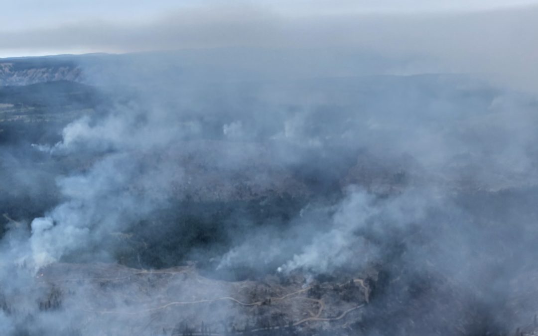
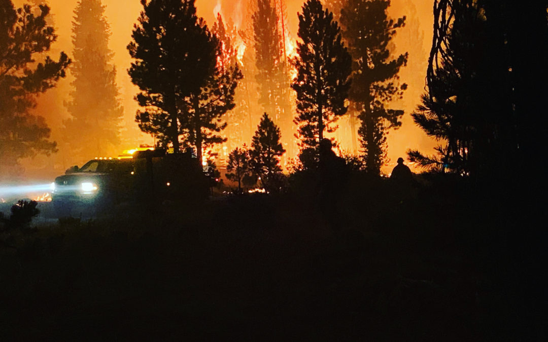
July 24, 2021
CURRENT FIRE SIZE AS OF 7/24/21 IR FLIGHT: 21,928 ACRES
CURRENT FIRE CONTAINMENT: 25%
LAST NIGHT AND TODAY:
Night operations were successful. No substantial growth of the fire was observed. Overall things are going well with no major concerns for today’s operations. Crews continue to work on “Plan B” contingency lines, tightening them up and making sure that they are secure. “Anchor, flank, pinch” is the phrase of the day.
Anchor: An advantageous location, usually a barrier to fire spread, from which to start constructing a fire line. The anchor point is used to minimize the chance of being flanked by the fire while the line is being constructed.
Flank: Attacking a fire by working along the flanks either simultaneously or successively from a less active or anchor point and endeavoring to connect two lines at the head.
Pinch: To cut off. Pinching two control lines together.
Fire crews are also taking advantages of small burnout operations, increasing containment line security by removing unburned fuels between the line and the main fire.
The fire now has eight helicopters assigned. Two of which are Type 1 (700 to 3,000 gallons) Blackhawks from the Oregon National Guard.
Elbow Creek Fire Information: 541-805-2784 (7 a.m. – 9 p.m.)
Email: elbowcreek.information@gmail.com
Facebook: www.facebook.com/ElbowCreekFire
Inciweb: inciweb.nwcg.gov/incident/7672/
Infrared flight over the Elbow Creek Fire on July 24, 2021.
July 24, 2021
Location: 28 miles northeast of Klamath Falls, OR
Size: 401,601 acres
Personnel: 2,224
Containment: 42%
Klamath Falls, ORE. –Yesterday, fireline construction progressed north from Long Creek toward Coyote Creek. The day shift was able to hold the fireline from the 400 Road to the south despite some active fire behavior that was pushing to the north and west. Night shift was able to work the area between Long Creek and Coyote Creek and construct direct fireline with dozers, hand crews, and hose lays. Crews continue to clear roads as a contingency plan above Sycan Marsh. Firefighters addressed spot fires on the northeastern flank and struggled to hold them. Burn out operations were performed from the 36 road to remove available unburned fuels to contain the spots. The burn out had favorable winds and good progress was made to protect the Summer Lake community. Night crews worked to hold those areas and perform additional burn out operations. Crews and resources have been repositioned to bases near Summer Lake and Paisely. This move will put crews and equipment closer to the active areas of the fire. The area around Summer Lake remains in Level 3 evacuation.
“This fire is resistant to stopping at dozer lines.” Jim Hansen, FBAN “With the critically dry weather and fuels we are experiencing, firefighters are having to constantly re-evaluate their control lines and look for contingency options.”
On the southeastern corner of the fire, crews worked through the night to strengthen the existing containment line. Areas of heat near the fire line were mopped up, a couple of spots over the line were extinguished, and slop over the fire line continues to be worked by crews. Today, crews will continue to hold, secure and monitor the fire on its southeastern edge.
Firefighters are actively patrolling and mopping areas along the western portion of the fire. This step is necessary to ensure that all heat that could threaten the security of the fire line has been extinguished. Resources continue to be shifted to meet the needs across the fire area. Firefighters from this fire may be called to provide initial attack response to new fire starts that have the potential to rapidly grow, given the extremely dry fuel conditions.
A Red Flag Warning is in effect this afternoon for dry and unstable atmospheric conditions. Temperatures today will be warmer and smoke and haze from nearby fires will linger through the day. The smoke is expected to keep temperatures down a couple degrees today which may help overall fire activity. Unfortunately, this smoke may impede air operations on the fire.
As a part of the normal two week rotation of Incident Management Teams (IMT), Alaska Type 1 IMTeam will begin arriving on the fire today. They will shadow the existing teams for several days and assume command of the fire on Tuesday, July 27th.
Evacuations: Evacuations are dynamic. An interactive map of evacuation levels in Lake and Klamath Counties is available at tinyurl.com/bootlegevac
Red Cross Evacuation Shelters: For information or assistance: 1-800-Red-Cross, (www.redcrossblog.org/disaster)
Closures: The Fremont-Winema National Forest is closed to the public in the fire area. Map and full order available at inciweb.nwcg.gov/incident/7609/.
Smoke: Northerly winds are expected over the next several days and could cause smoke to linger in Chiloquin, Lakeview, and communities in the Sprague River Valley. See: fires.airfire.org/outlooks/southcentraloregon.
Bootleg Fire Public Information
Zone 1 Email: bootleg.fire.information@gmail.com
Zone 2 Email: 2021.bootleg@firenet.gov
Public Line: 541-482-1331
Media Line: 971-727-7255
Inciweb: inciweb.nwcg.gov/incident/7609/
Facebook: www.facebook.com/BootlegFireInfo
Twitter: twitter.com/BootlegFireInfo
July 23, 2021
A Walk Around the Elbow Creek Fire Video: https://youtu.be/OOK5FKnVr_o
Wallowa, ORE. – The Elbow Creek fire is now 20,810 acres and remains 20 percent contained. Close to 900 personnel are currently assigned to the fire with resources from Washington, Texas, Arizona, New Mexico, Michigan, California, Oregon, South Carolina, and Idaho.
The most challenging area remains the confluence of drainages merging with the Grande Ronde River. Firefighters are being supported by several helicopters in the Elbow and Bear Creek areas as they work to pinch the fire off with the construction of hand line.
Crews continue to tie in and secure containment lines in the Sickfoot Creek area. Dozer and handlines get stronger daily and firefighters are hopeful to secure the area today and transition to full mop-up operations.
The east side of the fire has had little to no activity within the past four days as firefighters continue to patrol the area for flare ups.
The Oregon National Guard is arriving today with a fire suppression helicopter that will bring the total number of helicopters working on the fire to four.
The forecast calls for warmer and drier conditions with continued winds from all directions swirling within the canyons of the Grande Ronde River drainage. While the winds out of the northeast the past several days have complicated control efforts – a shift out of the southwest and west will be helpful today, pushing the fire back into itself on that western edge in the Bear Creek area.
Several forest closures remain in effect throughout Oregon. Be sure to check current conditions with local offices before visiting state and federal forests. “Know Before You Go.”
Evacuation levels within Wallowa County continue to change as fire and emergency management officials monitor the threat to communities. Additional information regarding evacuations is available on the Wallowa County Sheriff’s Office Facebook page (www.facebook.com/Wallowa-County-Sheriffs-Office-147212815486187).
Fire Information: 541-805-2784 (7 a.m. – 9 p.m.)
Email: ElbowCreek.information@gmail.com
Facebook: www.facebook.com/ElbowCreekFire
Inciweb: inciweb.nwcg.gov/incident/7672/
July 23, 2021
Location: 28 miles northeast of Klamath Falls, OR
Size: 400,389 acres
Personnel: 2,389
Containment: 40%
Klamath Falls, ORE. – The Oregon State Fire Marshall Incident Management Team has transitioned to working with Zone 2 on the north and northeast sections of the fire. Yesterday, the fireline into Long Creek was improved with hose lay and overnight firefighters were able to begin constructing direct line between Long Creek and Coyote Creek. Crews continue to work on the contingency lines in the northern portion of the fire above Sycan Marsh. Fire activity picked up in the eastern portion of the fire and spotted over Forest Service Road 2901. Last night crews and equipment worked using natural barriers and changes in fuel to contain the spot and protect the Summer Lake community. Crews will work today to hold those areas and scout for additional spots. Due to the fire’s movement to the east, additional Level 3 evacuations were issued for a portion of Lake County, from the Paisley Airport to mile post 82, and from Picture Rock Pass to mile post 77, including the Ana Subdivision. This area is in addition to the previous Level 3 notification.
“Our firefighters have put in an incredible amount of hard work on this fire,” said Joe Hessel, Incident Commander for the Oregon Department of Forestry Incident Management Team. “The fire continues to throw challenges at us, and we are going to continue to stay vigilant, work hard, and adapt.”
On the southeastern portion of the fire, crews worked through the night. There were some half-acre slops across the fire line, jackpots of fuel, and unburned islands that actively burned through the night. Today, firefighters will continue to secure the fireline, hold, and improve the control features.
Firefighters are actively patrolling and mopping areas along the southern portion of the fire. This step is necessary to ensure that all heat that could threaten the security of the fire line has been extinguished. Resources continue to be shifted to meet the needs across the fire area. Firefighters from this fire may be called to provide initial attack response to new fire starts that have the potential to rapidly grow, given the extremely dry fuel conditions.
Winds are expected to shift over the fire area today from a westerly flow to winds from the north or northwest. While these winds will be light, any shift in weather is a heads up situation for firefighters.
The Incident Command Post at Chiloquin High School is being dismantled today. Crews and resources have been repositioned to bases near Summer Lake and Paisley. This move will put crews and equipment closer to the active areas of the fire. The Incident Command Post will move to Klamath Falls and will be working out of the Klamath Community College.
Evacuations: Evacuations are dynamic. An interactive map of evacuation levels in Lake and Klamath Counties is available at tinyurl.com/bootlegevac
Red Cross Evacuation Shelters: Thrive Church – 235 South Laguna St. Klamath Falls, Oregon will be closing at 1800 Friday. For information or assistance: 1-800-Red-Cross, (www.redcrossblog.org/disaster)
Closures: The Fremont-Winema National Forest is closed to the public in the fire area. Map and full order available at inciweb.nwcg.gov/incident/7609/.
Smoke: Areas around Silver Lake, Summer Lake, and Paisley are experiencing generally improved air quality with some periods of heavy smoke continuing in the afternoon and evening. See: fires.airfire.org/outlooks/southcentraloregon.
Bootleg Fire Public Information
Zone 1 Email: bootleg.fire.information@gmail.com
Zone 2 Email: 2021.bootleg@firenet.gov
Public Line: 541-482-1331
Media Line: 971-727-7255
Inciweb: inciweb.nwcg.gov/incident/7609/
Facebook: www.facebook.com/BootlegFireInfo
Twitter: twitter.com/BootlegFireInfo
July 22, 2021
Media Inquiries: (971) 727-7255
Lakeview, ORE. – Incident Management Teams are working closely with local public health and Oregon Health Authority’s investigation into several positive cases of COVID-19 among resources working on the Bootleg Fire. Nine individuals have tested positive. In accordance with protocols developed in partnership with the Oregon Health Authority for the 2020 fire season, individuals reporting symptoms and those who worked closely with them are tested and isolated until results are received. Those who test positive are quarantined away from the fire camp. Due to the number of positive cases, this will be reported to OHA as a workplace outbreak, and updates on the number of positive cases associated with this outbreak will be included in OHA’s COVID-19 weekly report, which is issued every Wednesday.
Protecting the health and safety of firefighting personnel and those in the local community is the highest priority. This fire season has been slightly different due to the broad availability of vaccines and the prioritization of structural and wildland firefighting resources for vaccination in the spring. However, many of last year’s COVID-19 exposure mitigation measures are still in use at fire camps statewide. Measures currently in place at the incident camps include:
- Each team has a designated Health Liaison with a primary focus of providing for the mitigation of viral spread through the implementation of best practices. They also work with state and local authorities to manage suspected cases and provide for the efficient testing and contact tracing of fire resources.
- Ensuring the safety of incident responders and the public by implementing a thorough risk management process, to include incident operations planning that minimizes the impacts and spread of COVID-19.
- Providing wellness services such as handwash stations, ample sanitation and cleaning supplies, cleaning services to regularly disinfect frequent use surfaces.
- Food services have been designed to minimize contact between resources and support services.
- The camp has also been laid out to provide ample spacing for fire crews in accordance with social distancing guidelines and to minimize direct interactions between crews.
Fire managers remain committed to safe and effective firefighting operations. Teams will continue to partner with OHA and county public health officials to identify any opportunities to strengthen existing mitigation measures. Incident management personnel expect and hope for a full recovery of the firefighting resources.
