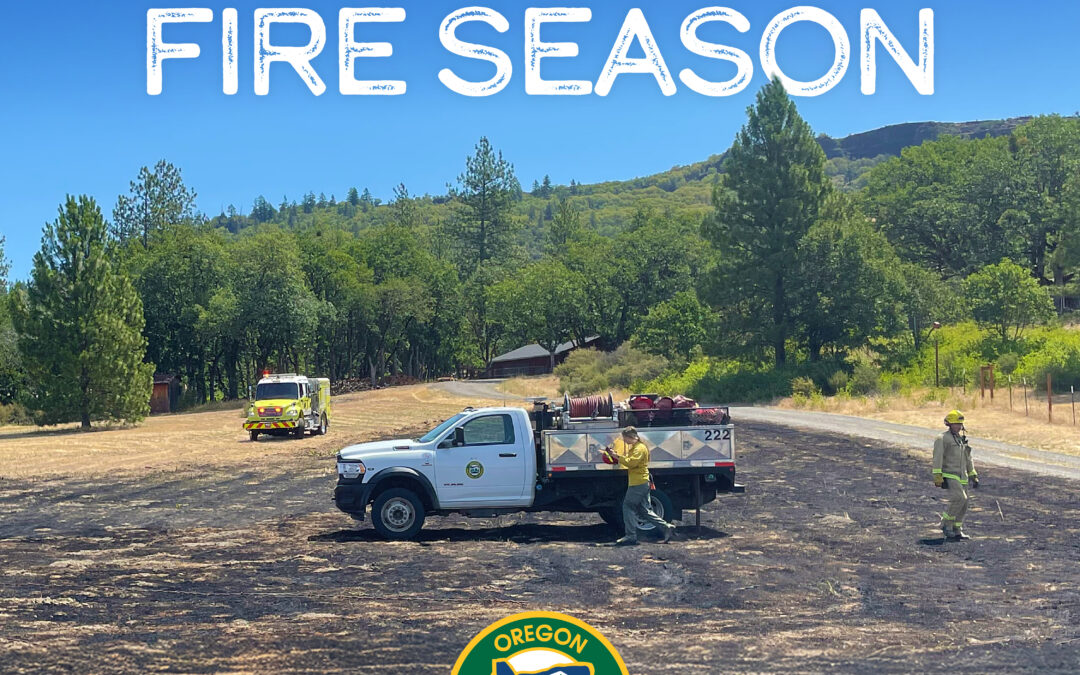
October 17, 2025
Salem, Ore.—Today, all Oregon Department of Forestry districts have terminated fire restrictions, marking the end of the 2025 Oregon fire season declaration.
“Oregon’s fire agency leadership, local communities and wildland firefighters have closed out this wildfire season with unmatched skill, coordination, and determination. Our state’s wildland firefighters set the standard here, nationally, and internationally. Thank you for your courage and selfless commitment to safeguarding this state and our communities year after year.” said Governor Tina Kotek.
“Through aggressive initial attack and the dedication of our firefighters, we had a season with significantly fewer acres burned compared to last year even with more fire starts,” said Kyle Williams, ODF Deputy Director of Fire Operations. “This year had the potential to be similar to last year, but ODF firefighters showed up every single day to make sure that did not happen.”
Combined, lightning-and human-caused fire brought roughly 100 more fire starts on ODF-protected land compared to 2024 fire season. In response, the departments protection districts and division took on the challenge.
“Due to the agency’s aggressive approach to initial attack to preserve natural resources, protect communities, and increase firefighter safety, many fire starts that happened this year were never heard about,” said Michael Curran, ODF Fire Protection Division Chief. “In 2025, 94 percent of fires on ODF-protected lands were put out at 10 acres or fewer.”
Year to date, there have been 1,135 fires on ODF-protected lands resulting in 24,275 acres burned. ODF Complex Incident Management Teams (CIMT) have been mobilized six times to wildfires this year. The assignments were to the following incidents:
- Rowena Fire
- Elk Fire
- Marks Creek Fire
- Grizzley Complex
- Flat Fire
- Kelsey Peak Fire
Statewide to date, regardless of jurisdiction, there have been 2,569 fires that have burned 288,774 acres.
The start and end of fire season restrictions and regulations are set by each forest protection district based on the conditions in their area including drought, climatic forecasts, and seasonal trends. These restrictions and regulations are on activities prone to start wildfires, such as debris burning and certain equipment use, and are intended as preventative measures during times with elevated wildfire risks. The arrival of steady soaking rain, coupled with cooler temperatures and shorter days, usually triggers the closure of fire season.
The end of fire season removes ODF imposed fire restrictions on ODF-protected lands. However, many structural fire departments in Oregon still require a permit for debris burning, and slash burning requires a permit year-round, so check with your local fire department or ODF office before starting a burn.
As Oregon transitions to fall and winter, ODF districts across the state are shifting their attention to wildfire prevention, fuels reduction, mitigation and planning efforts.
For more tips on how to keep yourself, your loved ones and your property safe from wildfire at any time of year, visit ODF’s Fire Prevention website or Keep Oregon Green’s website.
September 29, 2025
Salem, Ore. – The Oregon Department of Forestry (ODF) wants to remind Oregonians that even with the weather starting to transition to fall, fire is still on the landscape and fire regulations are still in effect. The department wants to warn the public against complacency since a season ending rain event has not happened yet and east winds, known to elevate fire risk, are a common occurrence this time of year.
“With the temperature changes, it’s easy to think that fires are lessening or that fire season is over. However, we are still seeing new fire starts daily throughout the state and fire regulations remain in place,” said Michael Curran, ODF Fire Protection Division Chief.
Even with lower temperatures and intermittent rain, fuels remain very dry with the potential for a fire to start and grow. Thus far in the season, there have been 1,091 fires on ODF-protected lands – 671 of which have been human-caused. By taking a few extra steps, you can help prevent the next wildfire in Oregon.
Wildfire prevention means:
- Debris burning remains the number one cause of human-caused fires in Oregon and is prohibited during fire season. Cover your pile and wait until fire season is declared over before burning. A dry, covered pile is cleaner and safer to burn in the late fall and winter.
- Check local restrictions before lighting a camp or warming fire to see if it is allowed.
- Never leave your campfire or warming fire unattended.
- Make sure your campfire or warming fire is OUT COLD. That means drowning it with water, stirring the ashes, and repeating that process until it is cold to touch. If there is any heat coming off the embers, then it can reignite later.
- Don’t park your car over dried grass, and make sure your vehicle or ATV is regularly serviced. More than 100 fires have resulted from vehicle use in 2025.
- Make sure your tow chains are not dragging. The metal hitting asphalt while driving can throw sparks into dry grass on the side of the road.
Several ODF districts have updated their fire danger levels recently; however most of the state remains between moderate and high fire danger. Visit Oregon.gov/odf to find local fire restrictions and keeporegongreen.org for more wildfire prevention tips.
September 25, 2025
Salem, OR –Two project proposals led by the Oregon Department of Forestry (ODF), along with four other projects in Oregon, have been selected to be funded by the Community Wildfire Defense Grant (CWDG). In total, organizations in Oregon have received $28.5 million to fund six projects, all with the end goal of creating more wildfire resilient communities.
ODF’s project proposals focus on assisting communities in reducing wildfire risk through mitigation work, education, defensible space assessments, becoming a Firewise USA site and more. ODF is also a partner on two other state projects that have been selected for funding.
“Wildfire seasons across the west are lasting longer and causing more devastation than ever before,” said Governor Tina Kotek. “Federal resources are critical for protecting Oregonians and Oregon’s natural resources. These funds will support fuels reduction, defensible space, and other invaluable landscape and community resiliency projects.”
The ODF proposals that have been selected for funding are:
- South Lane Wildfire Risk Reduction in the ODF Western Lane and South Cascade District – $2,624,890
This project will promote wildfire resilience in three disadvantaged Lane County communities, which have been identified as having high risk to catastrophic wildfire. The project will implement fuels reduction focused on private lands located in high density wildland urban interface (WUI) areas and support a wildfire prevention and education campaign, providing community members with educational materials promoting defensible space, wildfire awareness, and Firewise USA.
- Cave Junction-Takilma-Illinois Valley Mira Fuels Mitigation Project in the ODF Southwest Oregon District – $2,359,909
This project actively engages private landowners, provides technical assistance, and expands prescribed fire training opportunities, strengthening community resilience while reducing hazardous fuel loads. The project targets overgrown ladder fuels, selectively thinning to a clearance height of 10 to 14 feet. These efforts reduce crown fire potential, helping prevent rapid fire spread through tree canopies. Another key objective of the Mira project is prescribed fire implementation. In collaboration with partners, the project will conduct community-led under burns, hands-on training workshops, and Certified Burn Manager (CBM) courses.These efforts increase landowner participation in prescribed fire while reducing long-term dependence on mechanical fuel treatments. The project also enhances home and community protection through defensible space assessments and treatments, reducing fuels around structures and reinforcing fuel breaks along roadways and property boundaries. These firebreaks improve firefighter ingress/egress and provide critical suppression points during wildfire events. In total the project will support over 800 acres of hazardous fuels treatment, two CBM trainings, 100 defensible space assessments, two community workshops, four demonstration under burns, and establish two new Firewise Communities.
“Building wildfire resilient landscapes and communities is such a critical need throughout Oregon,” said Kate Skinner, interim State Forester and director of ODF. “We’re eager to get our boots on the ground and put this funding to good use protecting Oregonians.”
The CWDG program helps communities, tribes, non-profit organizations, state forestry agencies and Alaska Native corporations plan for and mitigate wildfire risks as the nation faces an ongoing wildfire crisis. Scoring priority was given to project proposals that are in an area identified as having a high or very high wildfire hazard potential, benefit a low-income community and/or are in a community that has been impacted by a severe disaster within the past 10 years that increased wildfire risk.
For more information on funded proposals in Oregon and nationally, visit www.fs.usda.gov/managing-land/fire/grants/funded-proposals.
September 18, 2025
LOWER ROGUE RIVER CORRIDOR, Ore. – Firefighters engaged on the Kelsey Peak Fire are continuing to finish mop-up operations and repairs, as well as hauling unneeded equipment off of the incident. The fire, now 95% contained as of Thursday morning, is located approximately 15 miles west of Glendale and was started by lightning on September 3.
Oregon Department of Forestry (ODF) Incident Management Team 1 has been assigned to the fire since September 8, and after 12 days, will be completing their final shift today. Despite steep terrain, dense brush, hazardous trees and rolling debris, firefighters were able to quickly build a control line around this fire and hold it at a final size of 1,039 acres during this timeframe.
On Wednesday, a local Type 3 team made up of ODF, Bureau of Land Management (BLM) Medford District and U.S. Forest Service Rogue River-Siskiyou National Forest resources was in-briefed on the current status of the fire and have been shadowing members of ODF Team 1 since. They will officially take command of the incident at 6 p.m. tonight to complete the final mop-up and repair work.
In response to the current status and containment of the fire, the Josephine County Sheriff’s Office and Emergency Management has canceled the Level 1 – BE READY evacuation notice for Zone JCU-801. A Level 1 – BE READY evacuation notice issued by the Curry County Sheriff’s Office remains in effect for Rogue River Ranch, Tucker Flat Campground and Marial due to the proximity of the Moon Complex.
Local resources will continue to coordinate with Great Basin Complex Incident Management Team (IMT) 5 on the Moon Complex, as well as the incoming Northwest IMT 13, which will take command of the Moon Complex on Saturday morning. Work to re-open old fire lines used during past fires as contingency lines for the east flank of the Moon Complex and mitigating fuels around structures in the Rogue River Ranch, Tucker Flats, and Marial areas will continue as needed to support the Moon Complex teams. For more information on the Moon Complex, visit https://www.facebook.com/SWORFireInfo
Rogue River Access: Fire activity can drastically alter the river environment. Please follow https://www.facebook.com/R6RRSNF and https://www.facebook.com/SWORFireInfo for updates regarding river access and impacts. Be aware of changing conditions and follow the direction of River Rangers and firefighting personnel along the river. Permitted boaters can contact the BLM Smullin Visitor Center at 541-618-2408 or BLM_OR_MD_Rogue_River_Mail@blm.gov with questions.
Closures: The Rogue River Trail is closed from Horseshoe Bend to Flora Dell. A temporary closure of a portion of the Grave Creek to Marial Backcountry Byway (BLM Road 32-9-14.2) has been implemented by the BLM Grants Pass Field Office. The public is strongly encouraged to avoid the entire Byway to facilitate safe firefighter access on the steep, narrow, windy road. Unauthorized individuals may not enter closed areas, and all uses—including hiking, hunting and dispersed camping—are prohibited. Please see the map for full closure information and updates on the BLM website: https://www.blm.gov/programs/public-safety-and-fire/fire-and-aviation/regional-info/oregon-washington/fire-restrictions
Evacuations: A Level 1 – BE READY evacuation notice from the Curry County Sheriff’s Office remains in effect for Rogue River Ranch, Tucker Flat Campground and Marial.
Temporary Flight Restriction (TFR): A “TFR” is in place at an altitude from the surface up to and including 7,000 feet, daily (24 hours) until further notice. Complete information is available at https://tfr.faa.gov/tfr3/?page=detail_5_8274. Flying a drone near or around a wildfire compromises the safety of pilots and interferes with firefighting efforts.
September 17, 2025
LOWER ROGUE RIVER CORRIDOR, Ore. – Firefighters on the Kelsey Peak Fire are rounding the corner on mop-up operations, extinguishing hotspots 300 feet into the fire’s perimeter on all sides. This work creates a strong barrier around the incident, located approximately 15 miles west of Glendale, preventing any future spread of fire in warm, windy conditions. Due to this tremendous progress firefighters have made, containment has risen to 90%, and the fire remains 1,039 acres in size.
Today, resources will continue to finish mopping up, as well as pulling unneeded equipment off the fire line. Helicopters will be working again to support ground crews, hauling equipment off the incident and saving firefighters from hiking it back out themselves on the steep terrain. The equipment will then be readied to be deployed for the next fire.
Additionally, repair work along fire lines is ongoing, as firefighters work to restore the disturbed landscape to a more natural state. Water bars will also be added on steep terrain to prevent soil erosion when consistent rain returns this fall and winter. Fire lines along ridges will be left open for potential future fire blocks if needed.
This afternoon, a local Type 3 Incident Management Team made up of Oregon Department of Forestry (ODF), Bureau of Land Management (BLM) and U.S. Forest Service Rogue River Siskiyou National Forest resources will be in-briefing with ODF Team 1 to get a current overview of the incident. These incoming resources will then spend Thursday shadowing the current team before taking command of the incident at 6 p.m. tomorrow evening.
Oregon Department of Forestry (ODF) Complex Incident Management Team 1 is coordinating with Great Basin Complex Incident Management Team 5 on the Moon Complex, approximately eight miles to the west. ODF Team 1 resources are re-opening old fire lines used during past fires as contingency lines for the east flank of the Moon Complex and mitigating fuels around structures in the Rogue River Ranch, Tucker Flats, and Marial areas to support Great Basin Team 5 objectives. For more information on the Moon Complex, visit https://www.facebook.com/SWORFireInfo
Rogue River Access: Fire activity can drastically alter the river environment. Please follow https://www.facebook.com/R6RRSNF and https://www.facebook.com/SWORFireInfo for updates regarding river access and impacts. Be aware of changing conditions and follow the direction of River Rangers and Firefighting personnel along the river. Permitted boaters can contact the BLM Smullin Visitor Center at 541-618-2408 or BLM_OR_MD_Rogue_River_Mail@blm.gov with questions.
Closures: The Rogue River Trail is closed from Horseshoe Bend to Flora Dell. A temporary closure of a portion of the Grave Creek to Marial Backcountry Byway (BLM Road 32-9-14.2) has been implemented by the BLM Grants Pass Field Office. The public is strongly encouraged to avoid the entire Byway to facilitate safe firefighter access on the steep, narrow, windy road. Unauthorized individuals may not enter closed areas, and all uses—including hiking, hunting and dispersed camping—are prohibited. Please see the map for full closure information on the BLM website: https://www.blm.gov/programs/public-safety-and-fire/fire-and-aviation/regional-info/oregon-washington/fire-restrictions
Evacuations: The Curry County Sheriff’s Office has reduced the evacuation order for Rogue River Ranch, Tucker Flat Campground and Marial to Level 1 – BE READY in response to increased containment. The Josephine County Sheriff’s Office and Emergency Management has a Level 1 – BE READY evacuation notice for Zone JCU-801 in place. More info: https://tinyurl.com/KelseyPeakEvacs
Temporary Flight Restriction (TFR): A “TFR” is in place at an altitude from the surface up to and including 7,000 feet, daily (24 hours) until further notice. Complete information is available at https://tfr.faa.gov/tfr3/?page=detail_5_8274. Flying a drone near or around a wildfire compromises the safety of pilots and interferes with firefighting efforts.
September 16, 2025
LOWER ROGUE RIVER CORRIDOR, Ore. – As mop-up on the Kelsey Peak Fire nears completion, firefighters are checking each piece of fireline for second and third times, ensuring no heat or flame remains near the perimeter. The fire, located 15 miles west of Glendale along the Lower Rogue River Corridor, has been burning since September 3rd in steep, rugged country with difficult access. Crews have worked hard to secure the fire and minimize impacts to the Wild and Scenic Rogue River. The fire is 1,039 acres with containment rising today to 85%. Curry County Sheriff’s Office has reduced the evacuation order for Rogue River Ranch, Tucker Flat Campground and Marial to Level 1 – BE READY in response to increased containment.
Mop-up depth along the control lines is nearing 300 feet in most areas. Yesterday, a Type 1 helicopter was used to drop water and cool some hot spots in the interior of the fire on the southern end. This area is very steep and rocky with limited access.
Helicopters remain available to support ground operations, including picking up equipment and hose which is no longer needed on the fireline. Using helicopters for backhaul makes the process quicker and reduces fatigue on firefighters who would have been hauling the equipment on their backs up the steep slopes.
Weather this week transitions to a warm dry trend with higher temperatures, lower humidities and windy conditions. This weather may fan smoldering embers in the interior of the fire, increasing visible smoke. Firefighters will be looking for these signs of fire and heat near the perimeter, extinguishing them in the mop-up process. Resources from the incident, including aircraft, are available to support local agencies in initial attack response to emerging fires.
Some resources have shifted their focus to repair work related to suppression activities, installing water-bars on control lines to divert run-off during rainy periods, mitigating soil erosion and impacts to water quality. Bull dozers are being used to flatten berms from fireline construction and eliminate areas where water can pool. These repair actions will reduce sediment delivery to the Rogue River and its tributaries.
Oregon Department of Forestry (ODF) Complex Incident Management Team 1 is coordinating with Great Basin Complex Incident Management Team 5 on the Moon Complex, approximately eight miles to the west. ODF Team 1 resources are re-opening old firelines used during past fires as contingency lines for the east flank of the Moon Complex and mitigating fuels around structures in the Rogue River Ranch, Tucker Flats, and Marial areas to support Great Basin Team 5 objectives. For more information on the Moon Complex, visit https://www.facebook.com/SWORFireInfo
Rogue River Access: Fire activity can drastically alter the river environment. Please follow https://www.facebook.com/R6RRSNF and https://www.facebook.com/SWORFireInfo for updates regarding river access and impacts. Be aware of changing conditions and follow the direction of River Rangers and Firefighting personnel along the river. Permitted boaters can contact the BLM Smullin Visitor Center at 541-618-2408 or BLM_OR_MD_Rogue_River_Mail@blm.gov with questions.
Closures: The Rogue River Trail is closed from Horseshoe Bend to Flora Dell. A temporary closure of a portion of the Grave Creek to Marial Backcountry Byway (BLM Road 32-9-14.2) has been implemented by the BLM Grants Pass Field Office. The public is strongly encouraged to avoid the entire Byway to facilitate safe firefighter access on the steep, narrow, windy road. Unauthorized individuals may not enter closed areas, and all uses—including hiking, hunting and dispersed camping—are prohibited. Please see the map for full closure information on the BLM website: https://www.blm.gov/programs/public-safety-and-fire/fire-and-aviation/regional-info/oregon-washington/fire-restrictions
Evacuations: The Curry County Sheriff’s Office issued a Level 2 – BE SET evacuation order for the area of Rogue River Ranch, Tucker Flat Campground and the nearby area of Marial. The Josephine County Sheriff’s Office and Emergency Management has a Level 1 – BE READY evacuation notice for Zone JCU-801 in place. More info: https://tinyurl.com/KelseyPeakEvacs
Temporary Flight Restriction (TFR): A “TFR” is in place at an altitude from the surface up to and including 7,000 feet, daily (24 hours) until further notice. Complete information is available at https://tfr.faa.gov/tfr3/?page=detail_5_8274. Flying a drone near or around a wildfire compromises the safety of pilots and interferes with firefighting efforts.
September 15, 2025
LOWER ROGUE RIVER CORRIDOR, Ore. – All control lines remain strong on the Kelsey Peak Fire as firefighters continue to push into the perimeter, extinguishing hot spots to build depth on the line. This work ultimately adds to overall containment, which has now reached 68%. The fire, located approximately 15 miles west of Glendale, is still being held by resources at 1,039 acres.
Rain was felt across the Kelsey Peak Fire early Sunday morning, continuing intermittently into the early afternoon. Rain totals varied from a quarter to four-tenths of an inch on the fire. This small weather system naturally aided resources during mop-up efforts but created slippery conditions on the steep slopes. Safety remains a top priority as work continues on tough terrain with numerous hazards. Hazardous trees that threaten firefighter safety are still being removed near the Kelsey Creek drainage on the east side of the fire. Firefighters also collected unneeded equipment in this area and brought it back to fire camp to be readied for the next incident.
Today, firefighters will continue mopping up across the fire; on the western and northern portions of line, resources have built between 200 and 250 feet of depth inside the perimeter. This work is tedious, requiring firefighters to methodically grid through areas looking for signs of heat or smoke. Smoldering vegetation can remain dormant until warm, windy weather causes it to flare up. With those exact conditions in the forecast later this week, this work is critical to retain control of the fire and continue to move forward in extinguishing it.
This upcoming shift in the weather is predicted to bring warmer temperatures, winds and lower relative humidity, starting today and worsening Tuesday. This combination can naturally fuel fire activity, and firefighters will be watching this week for any increase in fire behavior.
Oregon Department of Forestry (ODF) Complex Incident Management Team 1, assigned to the Kelsey Peak Fire since last Monday, is coordinating with the Great Basin Complex Incident Management Team 5 on the Moon Complex, approximately eight miles to the west. ODF Team 1 resources are re-opening old firelines used during past fires as contingency lines for the east flank of the Moon Complex and mitigating fuels around structures in the Rogue River Ranch, Tucker Flats, and Marial areas to support Great Basin Team 5 objectives. For more information on the Moon Complex, visit https://www.facebook.com/SWORFireInfo
Rogue River Access: Fire activity can drastically alter the river environment. Mitigation measures may be in place. It’s an evolving situation and updates will be shared as soon as possible. Permitted boaters can contact the BLM Smullin Visitor Center at 541-618-2408 or BLM_OR_MD_Rogue_River_Mail@blm.gov with questions about the status of the river.
Closures: The Rogue River Trail is closed from Horseshoe Bend to Flora Dell. A temporary closure of a portion of the Grave Creek to Marial Backcountry Byway (BLM Road 32-9-14.2) has been implemented by the BLM Grants Pass Field Office. The public is strongly encouraged to avoid the entire Byway to facilitate safe firefighter access on the steep, narrow, windy road. Unauthorized individuals may not enter closed areas, and all uses—including hiking, hunting and dispersed camping—are prohibited. Please see the map for full closure information on the BLM website: https://www.blm.gov/programs/public-safety-and-fire/fire-and-aviation/regional-info/oregon-washington/fire-restrictions
Evacuations: The Curry County Sheriff’s Office issued a Level 2 – BE SET evacuation order for the area of Rogue River Ranch, Tucker Flat Campground and the nearby area of Marial. The Josephine County Sheriff’s Office and Emergency Management has a Level 1 – BE READY evacuation notice for Zone JCU-801 in place. More info: https://tinyurl.com/KelseyPeakEvacs
Temporary Flight Restriction (TFR): A “TFR” is in place at an altitude from the surface up to and including 7,000 feet, daily (24 hours) until further notice. Complete information is available at https://tfr.faa.gov/tfr3/?page=detail_5_8274. Flying a drone near or around a wildfire compromises the safety of pilots and interferes with firefighting efforts.
September 14, 2025
LOWER ROGUE RIVER CORRIDOR, Ore. – Containment on the Kelsey Peak Fire increased to 44% as crews continue mop-up work around the perimeter. The lightning-sparked fire, located 15 miles west of Glendale in the Lower Rogue River Corridor, burned 1,039 acres in steep rugged terrain along the Kelsey Creek drainage.
Crews have constructed fireline around the perimeter of the fire and continue to strengthen the line, working into the interior of the fire nearly 200 feet in some areas. Unmanned Aircraft, equipped with infrared (IR) technology is being used to focus gridding on specific areas around the fire’s edge. Falling modules are working with crews and fire engines to mitigate overhead hazards as they move deeper into the interior of the fire looking for areas of heat and flame.
As containment increases for the fire and the perimeter is secured, hose and pumps that are no longer needed for containment efforts are being backhauled off the fireline to clean and prepare for use on the next incident. Overnight, resources focused on mopping up and patrolling the fire to ensure the fire remains within the current footprint.
Rain showers should diminish this morning, with partly sunny conditions expected today. This will begin a warming and drying trend for the next several days. As winds pick up later today, they may fan smoldering embers, increasing visible smoke and flames, aiding firefighters in identifying hot spots to extinguish.
Oregon Department of Forestry (ODF) Complex Incident Management Team 1, assigned to the Kelsey Peak Fire since last Monday, is coordinating with the Great Basin Complex Incident Management Team 5 on the Moon Complex, approximately eight miles to the west. ODF Team 1 resources are re-opening old firelines used during past fires as contingency lines for the east flank of the Moon Complex and mitigating fuels around structures in the Rogue River Ranch, Tucker Flats, and Marial areas to support Great Basin Team 5 objectives. For more information on the Moon Complex, visit https://www.facebook.com/SWORFireInfo
Rogue River Access: Fire activity can drastically alter the river environment. Mitigation measures may be in place. It’s an evolving situation and updates will be shared as soon as possible. Permitted boaters can contact the BLM Smullin Visitor Center at 541-618-2408 or BLM_OR_MD_Rogue_River_Mail@blm.gov with questions about the status of the river.
Closures: The Rogue River Trail is closed from Horseshoe Bend to Flora Dell. A temporary closure of a portion of the Grave Creek to Marial Backcountry Byway (BLM Road 32-9-14.2) has been implemented by the BLM Grants Pass Field Office. The public is strongly encouraged to avoid the entire Byway to facilitate safe firefighter access on the steep, narrow, windy road. Unauthorized individuals may not enter closed areas, and all uses—including hiking, hunting and dispersed camping—are prohibited. Please see the map for full closure information on the BLM website: https://www.blm.gov/programs/public-safety-and-fire/fire-and-aviation/regional-info/oregon-washington/fire-restrictions
Evacuations: The Curry County Sheriff’s Office decreased the Level 3 – GO NOW evacuation order for the area of Rogue River Ranch, Tucker Flat Campground and the nearby area of Marial to a Level 2 – BE SET. The Josephine County Sheriff’s Office and Emergency Management has a Level 1 – BE READY evacuation notice for Zone JCU-801 in place. More info: https://tinyurl.com/KelseyPeakEvacs
Temporary Flight Restriction (TFR): A “TFR” is in place at an altitude from the surface up to and including 7,000 feet, daily (24 hours) until further notice. Complete information is available at https://tfr.faa.gov/tfr3/?page=detail_5_8274. Flying a drone near or around a wildfire compromises the safety of pilots and interferes with firefighting efforts.
September 13, 2025
LOWER ROGUE RIVER CORRIDOR, Ore. – Firefighters on the Kelsey Peak Fire continue to push forward on strengthening lines and overall mop-up operations across the incident. The fire, located approximately 15 miles west of Glendale, is now 32% contained. This number is a direct reflection of the work firefighters have completed along the perimeter, extinguishing hotspots and bolstering the lines built to stop the fire’s growth.
From the west side of the fire to the northeast flank, crews have mopped up 70-100 feet into the interior of the fireline. On the east and south sides, a mix between bulldozer and hand-dug line is being strengthened. This work continued overnight and will again be the focus for Saturday. Infrared (IR) technology continues to be used to find areas still holding heat; with these locations mapped, firefighters can work more safely and efficiently to extinguish vegetation and roots that could flare up in warmer, windy conditions.
A Type 1 helicopter was also used yesterday to help extinguish hotspots. While aircraft can be helpful in remote locations, water bucket drops on the steep terrain can loosen trees and rocks and create a hazard for firefighters working on the line below. For that reason, aircraft have been used strategically, and sometimes sparingly, as the majority of work that needs to be completed requires firefighters on the ground.
Weather conditions are expected to heat up into the 80s once again on Saturday, giving firefighters an opportunity to see how their lines are holding. The heat will also help to naturally expose lingering hotspots that may begin smoking again in warmer temperatures. Tonight, a slight chance of rain and thunderstorms is possible, with storm chances holding through Sunday and warmer weather expected again next week.
Oregon Department of Forestry (ODF) Complex Incident Management Team 1, assigned to the Kelsey Peak Fire since last Monday, is working in coordination with the Great Basin Complex Incident Management Team 5 on the Moon Complex, approximately eight miles to the west. Due to closer proximity and easier road access, ODF Team 1 has been providing structure protection to the Zane Grey Cabin, the Rogue River Ranch and the area of Marial. Firefighters are also scouting for contingency lines in the event the Moon Complex fires move further east toward these areas. For more information on the Moon Complex, visit https://www.facebook.com/SWORFireInfo
Rogue River Access: Fire activity can drastically alter the river environment. Mitigation measures may be in place. It’s an evolving situation and updates will be shared as soon as possible. Permitted boaters can contact the BLM Smullin Visitor Center at 541-618-2408 or BLM_OR_MD_Rogue_River_Mail@blm.gov with questions about the status of the river.
Closures: The Rogue River Trail is closed from Horseshoe Bend to Flora Dell. A temporary closure of a portion of the Grave Creek to Marial Backcountry Byway (BLM Road 32-9-14.2) has been implemented by the BLM Grants Pass Field Office. The public is strongly encouraged to avoid the entire Byway to facilitate safe firefighter access on the steep, narrow, windy road. Unauthorized individuals may not enter closed areas, and all uses—including hiking, hunting and dispersed camping—are prohibited. Please see the map for full closure information on the BLM website: https://www.blm.gov/programs/public-safety-and-fire/fire-and-aviation/regional-info/oregon-washington/fire-restrictions
Evacuations: The Curry County Sheriff’s Office decreased the Level 3 – GO NOW evacuation order for the area of Rogue River Ranch, Tucker Flat Campground and the nearby area of Marial to a Level 2 – BE SET. The Josephine County Sheriff’s Office and Emergency Management has a Level 1 – BE READY evacuation notice for Zone JCU-801 in place. More info: https://tinyurl.com/KelseyPeakEvacs
Temporary Flight Restriction (TFR): A “TFR” is in place at an altitude from the surface up to and including 7,000 feet, daily (24 hours) until further notice. Complete information is available at https://tfr.faa.gov/tfr3/?page=detail_5_8274. Flying a drone near or around a wildfire compromises the safety of pilots and interferes with firefighting efforts.
Information for the Moon Complex is available here: https://tinyurl.com/MoonComplexInciweb.
September 12, 2025
LOWER ROGUE RIVER CORRIDOR, Ore. – Progress mopping up on the Kelsey Peak Fire has improved containment to 23%. This increased containment reflects the focused work crews have been accomplishing each day. Some portions of the fire have mopped up 100 feet into the interior of the fire.
“We aren’t building line out there to hold the fire today,” explained Operations Section Chief, Jason Pettigrew. “We are building line to hold the fire when its warmer and winds try to push it.”
Yesterday, helicopters were used to drop water on hot spots adjacent to the perimeter, moderating fire behavior and allowing firefighters to cool the area by stirring in water. They will be available again today for bucket work supporting firefighters and will be used to bring pumps and hose to the fireline in difficult terrain. This will improve water availability for mop-up.
Crews today are using infrared maps from an Unmanned Aircraft (UAS) flight late yesterday afternoon to identify areas of heat as they work around the fire’s edge mopping up. Using a drone (UAS) throughout the day provides immediate intel about hot spots to crews through updated maps, making mop up more efficient and improving safety as firefighters aren’t traversing the rugged terrain feeling for heat.
The Rogue River remains open for permitted boaters near the Kelsey Peak Fire, however firefighting activities may cause delays and smoke may limit visibility; boaters are encouraged to use caution on this part of the river.
Closures: The Rogue River Trail is closed from Horseshoe Bend to Flora Dell. A temporary closure of a portion of the Grave Creek to Marial Backcountry Byway (BLM Road 32-9-14.2) has been implemented by the BLM Grants Pass Field Office. The public is strongly encouraged to avoid the entire Byway to facilitate safe firefighter access on the steep, narrow, windy road. Unauthorized individuals may not enter closed areas, and all uses—including hiking, hunting and dispersed camping—are prohibited. Please see the map for full closure information on the BLM website: https://www.blm.gov/programs/public-safety-and-fire/fire-and-aviation/regional-info/oregon-washington/fire-restrictions
Evacuations: The Curry County Sheriff’s Office decreased the Level 3 – GO NOW evacuation order for the area of Rogue River Ranch, Tucker Flat Campground and the nearby area of Marial to a Level 2 – BE SET. The Josephine County Sheriff’s Office and Emergency Management has a Level 1 – BE READY evacuation notice for Zone JCU-801 in place. More info: https://tinyurl.com/KelseyPeakEvacs
Temporary Flight Restriction (TFR): A “TFR” is in place at an altitude from the surface up to and including 7,000 feet, daily (24 hours) until further notice. Complete information is available at https://tfr.faa.gov/tfr3/?page=detail_5_8274. Flying a drone near or around a wildfire compromises the safety of pilots and interferes with firefighting efforts.
Information for the Moon Complex is available here: https://tinyurl.com/MoonComplexInciweb.
September 11, 2025
PRINEVILLE, Ore. – Today will be the final shift managed by the Oregon Department of Forestry Complex Incident Management Team 2. ODF will be transitioning management of the fire to a local Type 4 team at 7:00AM tomorrow morning. The incoming team will continue working toward the same objectives of completing mop up and containment and working on suppression repair.
Overnight, crews worked on mopping up and gridding for any remaining hot spots along the fire line. Using handheld infrared cameras the crews did find a few remaining hot spots on the southwest side of the fire. Crews during the day will clean those up.
Today, crews will inspect previously mopped up areas of the line to ensure there are no remaining hot spots. They will also be pulling remaining equipment and hose from the line to ensure it is cleaned up before transfer of command to the Type 4 team. Suppression repair will continue today and be carried forward by the incoming team.
With work winding down around the fire, crews will be returning home. Please be aware of increased traffic and drive with caution and slow down in the fire area to ensure firefighter and public safety.
The ODF Incident Management Team sincerely thanks all cooperating agencies and the public for their support throughout this response. We are especially grateful to the local community. Their support played a vital role in our success.
Evacuations: Crook County Sheriff’s Office evacuation orders remain in place. An evacuation map is available on the Crook County Sheriff’s Facebook page at www.facebook.com/CrookCountySheriff/.
Local Area Closures: The U.S. Forest Service has implemented a temporary forest closure. For more information, please visit: https://www.fs.usda.gov/r06/ochoco/alerts/marks-creek-fire-area-closure.
September 11, 2025
LOWER ROGUE RIVER CORRIDOR, Ore. – Crews on the Kelsey Peak Fire completed control lines along the eastern edge of the fire from the East Fork of Kelsey Creek to the main Kelsey Creek drainage. Connecting the control line on the southern end of the fire to both the Kelsey Creek drainage on the east and the existing fireline on the western edge of the fire will be completed today. The southern area is rocky and steep; challenging fireline construction and access to the fire.
Firefighters will transition their focus today to mop-up around the fire, securing the perimeter. Overnight, an infrared flight over the fire identified areas of heat within the perimeter. Crews will use these maps to focus work on hot spots adjacent to the control line. Aircraft will be supporting operations today as needed and available to respond to new fires in the area.
Fire behavior is expected to increase today through Saturday as temperatures warm and fuels begin to dry out. This change in weather will help firefighters identify areas of heat as they mop-up adjacent to the fireline. Gridding for heat and extinguishing hotspots is difficult and especially challenging in the steep terrain. Despite recent rainy, cool weather, firefighters are finding heat in larger fuels and fire burning roots and organic material deep in the soil.
Oregon Department of Forestry’s Complex Incident Management Team 1 continues to focus on minimizing impacts of the Kelsey Peak Fire on the Lower Rogue River corridor, surrounding historic and private structures, cultural and environmental resources, and communities near the fire. Resource advisors are working with the team to provide input for protection of sensitive areas during suppression activities.
The Rogue River remains open for permitted boaters near the Kelsey Peak Fire. Firefighting activities on the Kelsey Peak Fire may cause delays; boaters are encouraged to use caution on this part of the river.
Closures: The Rogue River Trail is closed from Horseshoe Bend to Flora Dell. A temporary closure of a portion of the Grave Creek to Marial Backcountry Byway (BLM Road 32-9-14.2) has been implemented by the BLM Grants Pass Field Office. The public is strongly encouraged to avoid the entire Byway to facilitate safe firefighter access on the steep, narrow, windy road. Unauthorized individuals may not enter closed areas, and all uses—including hiking, hunting and dispersed camping—are prohibited. Please see the map for full closure information on the BLM website: https://www.blm.gov/programs/public-safety-and-fire/fire-and-aviation/regional-info/oregon-washington/fire-restrictions
Evacuations: The Curry County Sheriff’s Office decreased the Level 3 – GO NOW evacuation order for the area of Rogue River Ranch, Tucker Flat Campground and the nearby area of Marial to a Level 2 – BE SET. The Josephine County Sheriff’s Office and Emergency Management has a Level 1 – BE READY evacuation notice for Zone JCU-801 in place. More info: https://tinyurl.com/KelseyPeakEvacs
Temporary Flight Restriction (TFR): A “TFR” is in place at an altitude from the surface up to and including 7,000 feet, daily (24 hours) until further notice. Complete information is available at https://tfr.faa.gov/tfr3/?page=detail_5_8274. Flying a drone near or around a wildfire compromises the safety of pilots and interferes with firefighting efforts.
Information for the Moon Complex is available here: https://tinyurl.com/MoonComplexInciweb.
September 10, 2025
PRINEVILLE, Ore. – Throughout the day yesterday and overnight, firefighting crews continued to progress with mop up efforts around the entire perimeter of the fire, working 100 to 200 feet into the interior of the fire. Overnight, an infrared (IR) flight and crews using hand held infrared cameras identified hotspots remaining along the fire line.
Today, firefighters will address hot spots detected by the IR flight and IR cameras to ensure they are fully extinguished. Suppression repair on dozer lines will continue in order to prevent erosion and other long term resource impacts that result from fire suppression efforts.
More widespread rain showers are expected across the area today, and the National Weather Service has issued a flash flood watch which could impact the area. This presents a safety concern that firefighters are prepared to watch out for in order to stay safe on the line and in heading back to camp at the end of their shifts.
Highway 26 remains open; however, firefighters and heavy equipment are entering and exiting the roadway in multiple areas along the fire perimeter. Please drive with caution and slow down in the fire area to ensure firefighter and public safety.
Evacuations: Crook County Sheriff’s Office evacuation orders remain in place. An evacuation map is available on the Crook County Sheriff’s Facebook page at www.facebook.com/CrookCountySheriff/.
Local Area Closures: The U.S. Forest Service has implemented a temporary forest closure. For more information, please visit: https://www.fs.usda.gov/r06/ochoco/alerts/marks-creek-fire-area-closure.
September 10, 2025
LOWER ROGUE RIVER CORRIDOR, Ore. – Continued hard work by firefighters on the Kelsey Peak Fire, 15 miles west of Glendale, has increased containment to 12% for the incident. Control lines have been completed along the west, north, and northeast areas of the fire. Fireline has been constructed directly on the fire’s edge in these areas, and crews are mopping up into the interior and gridding for heat.
Steep, rugged terrain and thick vegetation make both line construction and mop-up challenging for fire crews. There have been no accidents or injuries on the incident since the fire was reported on September 3, 2025.
Crews continue working to secure the perimeter of the fire as weather transitions to warmer and drier conditions. Nearly ¾ of an inch of rain has fallen across the incident in the last 36 hours, temporarily reducing fire behavior, but as fuels begin to dry smoke and flames will be more visible. Reduced fire behavior is allowing crews to construct the line at the fire’s edge, minimizing the overall size of the fire. An infrared flight overnight showed hotspots along the east perimeter where crews are working to connect control lines and increase the mop-up depth adjacent to the fireline.
Overnight improved access to the southeast corner of the fire was completed; today crews will continue direct fireline construction as conditions allow and build hoselays, increasing water availability for mop-up along the control lines.
“It was a great night!” Brent O’Nion, Night Operations Section Chief, stated during the morning operational briefing. “Night crews built off the work you guys put in yesterday, extending the mop-up depth and getting into Kelsey Creek to begin direct handline construction on the southeast corner!”
Nine helicopters are assigned to the fire to support ground resources in the suppression efforts. Smoke has limited visibility, but as conditions improve, they will engage. Air resources from the Kelsey Peak Fire are also supporting initial attack activities in coordination with local agencies.
The Rogue River remains open for permitted boaters near the Kelsey Peak Fire, however further downriver, restrictions are in place. Additional information is available here: https://tinyurl.com/MoonComplexInciweb
Firefighting activities on the Kelsey Peak Fire may cause delays; boaters are encouraged to use caution on this part of the river.
Closures: The Rogue River Trail is closed from Horseshoe Bend to Flora Dell. A temporary closure of a portion of the Grave Creek to Marial Backcountry Byway (BLM Road 32-9-14.2) has been implemented by the BLM Grants Pass Field Office. The public is strongly encouraged to avoid the entire Byway to facilitate safe firefighter access on the steep, narrow, windy road. Unauthorized individuals may not enter closed areas, and all uses—including hiking, hunting and dispersed camping—are prohibited. Please see the map for full closure information on the BLM website: https://www.blm.gov/programs/public-safety-and-fire/fire-and-aviation/regional-info/oregon-washington/fire-restrictions
Evacuations: The Curry County Sheriff’s Office decreased the Level 3 – GO NOW evacuation order for the area of Rogue River Ranch, Tucker Flat Campground and the nearby area of Marial to a Level 2 – BE SET. The Josephine County Sheriff’s Office and Emergency Management has a Level 1 – BE READY evacuation notice for Zone JCU-801 in place. More info: https://tinyurl.com/KelseyPeakEvacs
Temporary Flight Restriction (TFR): A “TFR” is in place at an altitude from the surface up to and including 7,000 feet, daily (24 hours) until further notice. Complete information is available at https://tfr.faa.gov/tfr3/?page=detail_5_8274. Flying a drone near or around a wildfire compromises the safety of pilots and interferes with firefighting efforts.
September 9, 2025
LOWER ROGUE RIVER CORRIDOR, Ore. – Resources assigned to the Kelsey Peak Fire continued to push forward on lining the perimeter Tuesday, making headway from the northwestern to the northeastern sides of the incident. Cooler temperatures and intermittent rain has naturally helped to decrease fire behavior, providing opportunities for firefighters to make fast progress in areas that once proved difficult in hotter weather and more active fire. It’s also allowing firefighters to put in direct line up against the fire’s edge, keeping the fire as small as possible and minimizing further growth.
Due to the current conditions, minimized fire behavior and work completed by resources on the line, the Curry County Sherrif’s Office has decreased the Level 3 – Go Now evacuation for the Rogue River Ranch, Tucker Flat Campground and the nearby area of Marial to a Level 2 – Be Set notice. The Level 1 – Be Ready evacuation for Zone JCU-801 in Josephine County to the southeast of the fire remains in place.
Today, resources furthered plans of protection for these structures in the Level 2 evacuation area, as well as the Zane Grey Cabin. These procedures are precautionary, however with multiple fires in the area, firefighters are taking every opportunity possible to ensure plans are in place, especially with residents and guests returning.
Meanwhile, mop-up operations are continuing on the northeastern lines, reaching up to 70-feet into the interior of the fire. This work ensures all lingering heat is extinguished and won’t flare up again in warm, windy weather, expected by the end of this week. As lines are connected and solidified, mop-up work will begin on other portions of the fire, boosting containment across the incident.
The Rogue River remains open for permitted boaters near the Kelsey Peak Fire, however further downriver, restrictions are in place. Additional information is available here: https://tinyurl.com/MoonComplexInciweb
Firefighting activities on the Kelsey Peak Fire may cause delays; boaters are encouraged to use caution on this part of the river.
Closures: The Rogue River Trail is closed from Horseshoe Bend to Flora Dell. A temporary closure of a portion of the Grave Creek to Marial Backcountry Byway (BLM Road 32-9-14.2) has been implemented by the BLM Grants Pass Field Office. The public is strongly encouraged to avoid the entire Byway to facilitate safe firefighter access on the steep, narrow, windy road. Unauthorized individuals may not enter closed areas, and all uses—including hiking, hunting and dispersed camping—are prohibited. Please see the map for full closure information on the BLM website: https://www.blm.gov/programs/public-safety-and-fire/fire-and-aviation/regional-info/oregon-washington/fire-restrictions
Evacuations: The Curry County Sheriff’s Office decreased the Level 3 – GO NOW evacuation order for the area of Rogue River Ranch, Tucker Flat Campground and the nearby area of Marial to a Level 2 – BE SET. The Josephine County Sheriff’s Office and Emergency Management issued a Level 1 – BE READY evacuation notice Zone JCU-801. More info: https://tinyurl.com/KelseyPeakEvacs
Temporary Flight Restriction (TFR): A “TFR” is in place at an altitude from the surface up to and including 7,000 feet, daily (24 hours) until further notice. Complete information is available at https://tfr.faa.gov/tfr3/?page=detail_5_8274. Flying a drone near or around a wildfire compromises the safety of pilots and interferes with firefighting efforts.
September 9, 2025
LOWER ROGUE RIVER CORRIDOR, Ore. – Rain over the Kelsey Peak Fire beginning late Monday evening continued, moderating fire behavior across the incident overnight. Firefighters were able to focus on mop-up into the interior of the fire on the western edge and bulldozers were used to extend the control line southward. Today firefighters will work to find terrain features along the southern perimeter to construct control lines connecting to the western edge.
Mop-up along the northern control line extended up to 50 feet into the interior on the northwest corner. Crews were able to expose areas of heat buried such as burning roots, using higher humidity and water to extinguish the hotspots. Today resources will continue this work moving further along the control line to secure the fire.
Rain showers are expected today, aiding in suppression efforts, however afternoon thunderstorms could bring erratic winds over the fire. Firefighters were reminded at briefing that the rainy conditions increase hazards in the fire area, and they need to be mindful as they work. Incident objectives for Oregon Department of Forestry’s Complex Incident Management Team 1 include prioritizing public and firefighter safety during suppression activities.
On the eastern side of the fire, crews and equipment have improved access and are constructing fireline adjacent to the fire’s edge where possible in the rugged terrain. Overnight handline was completed from the jeep trail in the northeast corner of the fire down to Kelsey Creek; today efforts will focus on building line from the jeep trail toward East Fork of Kelsey Creek.
The Rogue River remains open for permitted boaters near the Kelsey Peak Fire, however further downriver, restrictions are in place. Additional information is available here: https://tinyurl.com/MoonComplexInciweb
Firefighting activities on the Kelsey Peak Fire may cause delays, boaters are encouraged to use caution on this part of the river.
Closures: The Rogue River Trail is closed from Horseshoe Bend to Flora Dell. A temporary closure of a portion of the Grave Creek to Marial Backcountry Byway (BLM Road 32-9-14.2) has been implemented by the BLM Grants Pass Field Office. The public is strongly encouraged to avoid the entire Byway to facilitate safe firefighter access on the steep, narrow, windy road. Members of the public may not enter closed areas, and all uses—including hiking, hunting and dispersed camping—are prohibited. Please see the map for full closure information on the BLM website: https://www.blm.gov/programs/public-safety-and-fire/fire-and-aviation/regional-info/oregon-washington/fire-restrictions
Evacuations: The Curry County Sheriff’s Office issued a Level 3 – GO NOW evacuation order for the area of Rogue River Ranch, Tucker Flat Campground and the nearby area of Marial. The Josephine County Sheriff’s Office and Emergency Management issued a Level 1 – BE READY evacuation notice Zone JCU-801. More info: https://tinyurl.com/KelseyPeakEvacs
Temporary Flight Restriction (TFR): A “TFR” is in place at an altitude from the surface up to and including 7,000 feet, daily (24 hours) until further notice. Complete information is available at https://tfr.faa.gov/tfr3/?page=detail_5_8274. Flying a drone near or around a wildfire compromises the safety of pilots and interferes with firefighting efforts.
September 9, 2025
PRINEVILLE, Ore. – Fire crews continue to maintain the control lines around the perimeter of the Marks Creek Fire. Sustained progress on the depth of the cold line has allowed crews to mop up deeper into the interior of the fire on all sides.
Hand held infrared sensors found 15 to 20 hot spots on the southeastern lines, but overall, lines were found to be much cooler overnight, allowing for great work to continue on attacking areas of heat.
Today, suppression repair on internal dozer lines has started, installing water bars and buttoning up any disturbance, along with continued suppression repairs on exterior lines using excavators.
The expected low pressure system did not arrive inland overnight, inhibiting the showers that were expected. Dynamic weather conditions will still present challenges, so crews were reminded to stay vigilant and be flexible under changing conditions.
Highway 26 remains open; however, firefighters and heavy equipment are entering and exiting the roadway in multiple areas along the fire perimeter. Please drive with caution and slow down in the fire area to ensure firefighter and public safety.
Evacuations: Crook County Sheriff’s Office evacuation orders remain in place. An evacuation map is available on the Crook County Sheriff’s Facebook page at www.facebook.com/CrookCountySheriff/.
Local Area Closures: The U.S. Forest Service has implemented a temporary forest closure. For more information, please visit: https://www.fs.usda.gov/r06/ochoco/alerts/marks-creek-fire-area-closure.
September 8, 2025
PRINEVILLE, Ore. – Progress around the Marks Creek Fire continues as the entire fire has been plumbed and the depth of cold line continues to build into the interior of the fire. The north tip of the fire has cold fire line up to 200 feet deep while the rest of the fire averages 50 to 150 feet deep.
Overnight, the eastern side and southern edges of the fire will be worked using the infrared handheld units identifying any hot spots in the interior. Any spots found will be flagged for the day shift to extinguish.
Progress will continue with cooler weather and rain expected over the fire area overnight and tomorrow. The crews will adjust their tactics to account for changing conditions on the fire line.
Highway 26 remains open; however, firefighters and heavy equipment are entering and exiting the roadway in multiple areas along the fire perimeter. Please drive with caution and slow down in the fire area to ensure firefighter and public safety.
Evacuations: Crook County Sheriff’s Office evacuation orders remain in place. An evacuation map is available on the Crook County Sheriff’s Facebook page at www.facebook.com/CrookCountySheriff/.
Local Area Closures: The U.S. Forest Service has implemented a temporary forest closure. For more information, please visit: https://www.fs.usda.gov/r06/ochoco/alerts/marks-creek-fire-area-closure.
This will be the final evening update. Morning updates will continue until the team transitions the fire back to the local unit.
September 8, 2025
LOWER ROGUE RIVER CORRIDOR, Ore. – Firefighters continued to build line Monday on the Kelsey Peak Fire, located on Bureau of Land Management (BLM) land approximately 15 miles west of Glendale. The western portions of line are holding well, and crews on the north and northwest areas worked to connect lines today. These operations are key to keeping the fire as small as possible and stopping its growth, which remains a top priority for the Oregon Department of Forestry (ODF) Complex Incident Management Team (CIMT) 1 assigned to the incident, as well as the ODF Southwest Oregon District and BLM Medford District.
This morning, minimal fire growth was observed on the southwest and east sides of the fire; firefighters worked to keep the fire from spreading further in these areas. Changes in the weather were felt in the late afternoon, with cooler temperatures and showers observed by firefighters on the line, as well as thunderstorms over the fire and across southern Oregon.
While the rain is helpful in naturally slowing fire growth, it won’t extinguish the fire; firefighters are capitalizing on the decreased fire activity and pushing forward in their work. Rain and thunderstorms remain in the forecast in the coming days, creating the potential for new lightning-caused fire starts. Kelsey Peak Fire resources are available to support the initial attack of new wildfires as needed.
Tonight, resources will continue to focus on connecting lines around the fire and bolstering their strength where possible. As this work continues, containment on the fire will begin to be reflected.
The fire is burning north of the Rogue River along the Kelsey Creek drainage on steep terrain with dense vegetation, limited road access, and numerous hazards, including falling trees, rolling debris and snakes. Public and firefighter safety are top priorities on this incident.
The Rogue River remains open for permitted boaters near the Kelsey Peak Fire, however further downriver, restrictions are in place. Additional information is available here: https://tinyurl.com/MoonComplexInciweb
In the area of the Kelsey Peak Fire, firefighting activities may cause delays on the river.
Closures: The Rogue River Trail is closed from Horseshoe Bend to Flora Dell. A temporary closure of a portion of the Grave Creek to Marial Backcountry Byway (BLM Road 32-9-14.2) has been implemented by the BLM Grants Pass Field Office. The public is strongly encouraged to avoid the entire Byway to facilitate safe firefighter access on the steep, narrow, windy road. Members of the public may not enter closed areas, and all uses—including hiking, hunting and dispersed camping—are prohibited. Please see the map for full closure information on the BLM website: https://www.blm.gov/programs/public-safety-and-fire/fire-and-aviation/regional-info/oregon-washington/fire-restrictions
Evacuations: The Curry County Sheriff’s Office issued a Level 3 – GO NOW evacuation order for the area of Rogue River Ranch, Tucker Flat Campground and the nearby area of Marial. The Josephine County Sheriff’s Office and Emergency Management issued a Level 1 – BE READY evacuation notice Zone JCU-801. More info: https://tinyurl.com/KelseyPeakEvacs
Temporary Flight Restriction (TFR): A “TFR” is in place at an altitude from the surface up to and including 7,000 feet, daily (24 hours) until further notice. Complete information is available at https://tfr.faa.gov/tfr3/?page=detail_5_8274. Flying a drone near or around a wildfire compromises the safety of pilots and interferes with firefighting efforts.
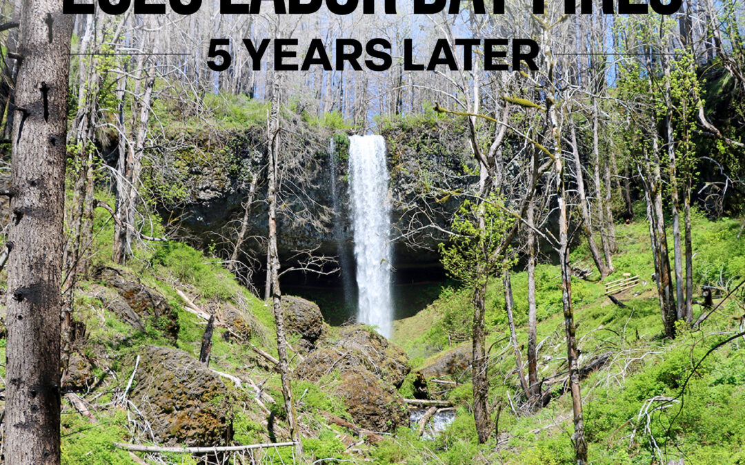
September 8, 2025
September 7 marked five years after the 2020 Labor Day fires, an event that severely impacted so many people throughout the state. On Labor Day of 2020, a historic wind event combined with record dry fuels created incredibly dangerous fire conditions. In just a few days, nearly a million acres were burned in fast-spreading fires across western and south-central Oregon and multiple communities were unfortunately in the footprints of those fires.
One of the affected areas was the Santiam State Forest that ODF manages. Since those fires, ODF has been working hard over the last five years to help the forest recover.
From over five years of work, multiple wilderness areas in the forest have reopened in that time, the most notable being the Shellburg Falls and High Lakes Recreation Areas. As reforestation efforts across the state continue, ODF remains engaged every step of the way.
At its peak, the Labor Day wildfire incidents had over 7,500 assigned personnel from Oregon, 39 other states and Canada. That doesn’t include many of the government employees, landowners, forest operators, and members of the community who contributed to the fight.
After the fires, the Oregon Department of Forestry saw the immense need for mental health support for our firefighters. The Peer Support Team was officially launched before the 2022 fire season but had its beginnings in 2020, in the aftermath of the Labor Day fires, a non-fire related ODF employee death, and the impacts of the COVID pandemic.
The team is an official internal resource with a focus on mental health awareness, better understanding and mitigating its effects, and ultimately building employee resiliency. Each team member receives in-depth training and is required to maintain confidentially in all their interactions.
Though significant progress has been made over the last five years internally and externally, The Oregon Department of Forestry recognizes that progress is not linear and there is still a lot of work to be done.