ODF Incident Management Teams
- Team 1 is in command of the Battle Mountain Complex – Zone 1 and Courtrock fire near Monument (ODF Central Oregon District). Updates available on the incident’s Facebook page.
- Team 3 is in command of the Battle Mountain Complex – Zone 2 near Ukiah (ODF Northeast Oregon District). Governor Kotek has invoked the Emergency Conflagration Act for this fire. Updates available on the incident’s Facebook page.
- North Carolina Forest Service Complex Incident Management Team (CIMT) is in command of the Cottage Grove Complex (ODF South Cascade District). Updates available on the incident’s Facebook page. This team was ordered in by ODF through a state-to-state mutual aid agreement.
- Team 2 is currently on rotation.
ODF Priority Fires
| FIRE NAME | ACRES BURNED (est. acres) | CONTAINMENT | LOCATION | COMMAND |
| Courtrock | 9,915 | 9% | 7 miles South of Monument | ODF IMT 1 |
| Battle Mountain Complex | 140,879 | 5% | West of Ukiah | ODF IMT 3 |
| Cottage Grove – Lane 1 Fires | 5,391 | Lane 1 at 10%
All others at 0% |
East of Cottage Grove | NC CIMT |
| Lone Rock | 136,377 | 45% | 10 miles SE of Condon | NW Team 2/OSFM Red Team |
| Durkee | 284,273 | 20% | 5 miles SW of Durkee | NW Team 6/OSFM Green Team |
| Falls | 140,422 | 55% | 20 miles NW of Burns | NW Team 8/OSFM Blue Team |
| Whisky Creek | 856 | 0% | 6 miles SE of Cascade Locks | GB Team 6 |
| Microwave | 762 | 53% | 5 miles SW of Mosier | GB Team 6 |
| Telephone | 9,000 | 0% | 16 miles N of Burns | NW Team 8 |
| Pyramid | 615 | 5% | 15 miles S of Detroit | CA IMT 5 |
| Slate | 45 | 0% | S of the Detroit Resevoir | CA IMT 5 |
| Crazy Creek | 11,008 | 0% | 16 miles E of Paulina | ICT 3 |
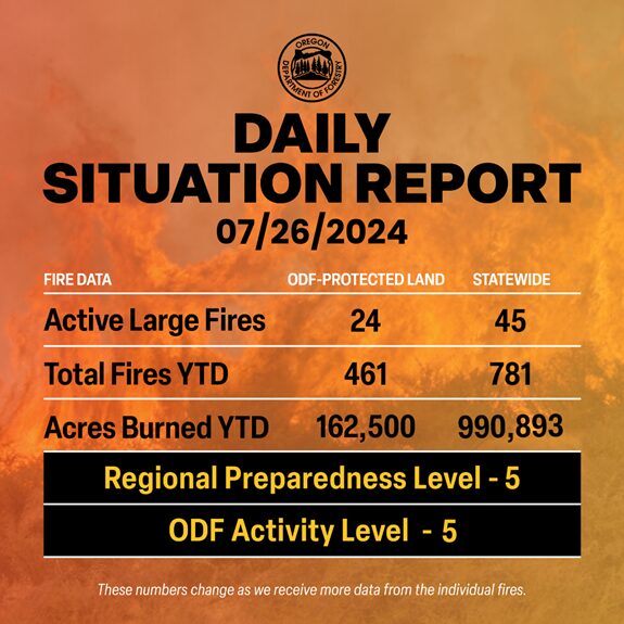
There are approximately 8,346 personnel assigned to the 45 large fires across the state, not including many of the local and agency government employees, landowners, forestland operators, and members of the community who are contributing every day.
ODF Highlight: Multi-mission Aviation
So far this season, ODF’s multi-mission aircraft has been first to detect 14 fires statewide. But detection is just one of its multiple missions. The aircraft has also been collecting data and imagery over some of the state’s large fires. This information is critical to the fire managers on the ground, and thanks to a satellite antenna, it can be livestreamed or uploaded immediately. The MMA typically runs night missions, and trained personnel on the aircraft use night-vision goggles, infrared sensors and augmented reality software to pull a clear operational picture out of the darkness.
ODF has also been leveraging a much smaller aircraft this season. The department is one of the only states with drone contracts for wildfire response. Drone missions this fire season have included heat mapping, photography, videography, aerial ignitions and LiDAR mapping.
Weather
Westerly general winds will continue today along the east slopes of the Cascades and through the gaps. Less wind is expected today in the Columbia Basin and southeastern Oregon. There are widespread areas of smoke near and downwind of ongoing fires. Temperatures are a little below normal on the east side and well below normal on the west side. East of the Cascades, the potential for new large fires and overall growth of existing fires will decrease further east of the Cascades on Friday and Saturday due to lack of lightning and less wind. West of the Cascades, the potential for new significant fires has dropped below normal due to fuels moisture, cooler weather and possible light rain early next week.
Prevention
While conditions on the ground are getting a bit better, fire danger is still high or extreme. We need Oregonians to help our people on the ground by preventing human-caused fires. Every new fire puts more of a strain on firefighters and diverts resources away from focusing on the many fires we already have out there. Please, know the fire danger level of the areas where you live, work and play, and follow all local restrictions on burning, equipment use, campfires and other activities that can start wildfires. Find danger levels and restrictions across the state here.
Resources
- ODF wildfire blog and Public Fire Restrictions/Danger Levels map
- Regional situation report and national situation report
- Inciweb (information, photos, videos, and maps from specific incidents)

