August 25, 2025
SISTERS, Ore. (August 25, 2025) — The Flat Fire is estimated at 21,971 acres with 5% containment. The fire is burning approximately two miles northeast of Sisters, Oregon.
Crews made significant progress today, aided by more favorable weather. Cooler temperatures and higher humidity helped stabilize conditions, allowing firefighters to shift from catching the fire to holding and securing the perimeter. Firefighters across the incident worked hard to strengthen and expand lines, and as of this evening, the fire is fully lined.
Structural strike teams remained in place within residential areas, working throughout the day to extinguish hot spots and patrol for embers. Crews have been aided in their efforts by the proactive home hardening and defensible space measures of home and property owners. These efforts, combined with the significant progress made today by wildland resources, have allowed OSFM to demobilize a local task force and a strike team this evening. These crews were part of the initial attack response and will be returning to serve their home agencies here in Central Oregon. OSFM task forces remain dedicated to the impacted area, providing structural protection around the clock.
There were decreases in evacuation levels within both Deschutes and Jefferson Counties this evening. Evacuations are managed by the Deschutes County Sheriff’s Office and the Jefferson County Sheriff’s Office. Please follow their Facebook pages for the latest updates.
While the precipitation provided some relief, fuels remain dry, and a heat advisory also continues through Wednesday, keeping conditions challenging for firefighting efforts. Tonight, firefighters will continue to improve the security of established lines ahead of expected warmer weather. Falling work to remove fire-affected trees is also underway to improve access to structures and reduce overhead dangers to firefighters.
Tonight’s public meeting was attended in person by nearly 1,000 community members. We appreciate the outpouring of support and the opportunity to connect with the community. A recording of the meeting is available on our Facebook page.
Evacuations:
Evacuations are managed by the Deschutes County Sheriff’s Office and the Jefferson County Sheriff’s Office.
Level 1, 2 and 3 evacuations remain in effect under the direction of the Deschutes County Sheriff’s Office and the Jefferson County Sheriff’s Office. Follow their Facebook pages for the latest information and updates. They can also be reached by phone: Deschutes County Sheriff’s Office at (541) 388-6655, and Jefferson County Sheriff’s Office (541) 475-6520.
A 24-hour evacuation shelter has been set up by the Red Cross at Highland Baptist Church located at: 3100 SW Highland Ave, Redmond, OR. Jefferson County Fairgrounds in Madras and Kerley Horse Center in Powell Butte are available for large animals.
Local Area closures: To help fire operations and firefighter safety, the Bureau of Land Management and U.S. Forest Service ask that people stay out of the fire area. The BLM has implemented closures, which can be found under the Prineville tab on the following page: https://www.blm.gov/programs/public-safety-and-fire/fire-and-aviation/regional-info/oregon-washington/fire-restrictions.
As a reminder, drone use near fires is both illegal and extremely dangerous to pilots working on incidents. If you fly, we can’t. FAA Temporary Flight Restrictions are in place for the fire area. All illegal drone use will be reported to law enforcement.
Local Road closures: The Deschutes County Sheriff is managing several local road closures.
· Wilt Road is closed at Camp Polk Road
· Panoramic Drive is closed at Camp Polk Road
· Goodrich Road closed north of Hwy 126
· Holmes Road closed north of Fadjur Lane
Smoke Report: Air quality continues to change. For current conditions, please visit: https://fire.airnow.gov/
August 25, 2025
ODF Complex Incident Management Teams
- Team 3 is assigned to the Flat Fire in the Central Oregon District. Follow the incident’s Facebook page for updates. Incident officials will host a community meeting tonight at 6:00 pm at Sisters High School. The meeting will be streamed virtually via the Sisters-Camp Sherman Fire Department Facebook page.
- Team 1 is on rotation.
- Team 2 is on call.
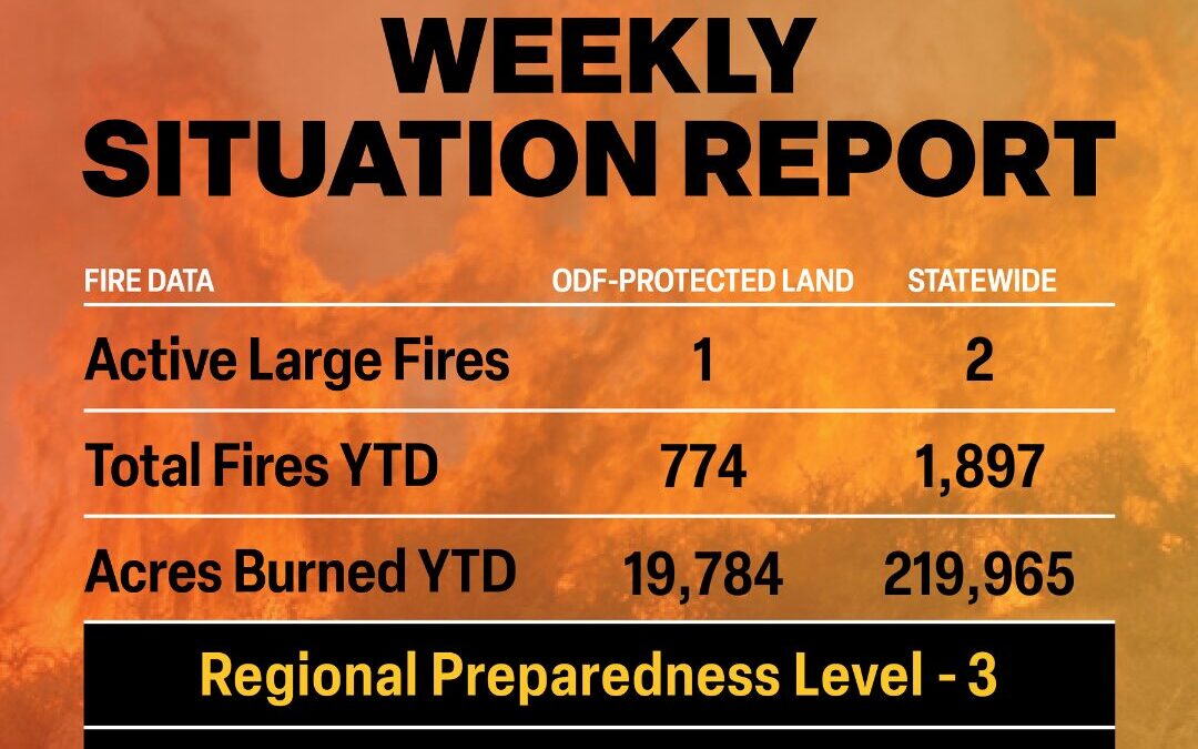
ODF Priority Fires
| FIRE NAME |
TOTAL ACRES |
ODF ACRES |
CONTAINMENT |
LOCATION |
COMMAND |
| Flat |
21,971 |
6,440* |
5% |
7 miles W of Culver |
ODF CIMT 3/ OSFM Red Team |
*These numbers may change as we receive more data.
There are approximately 801 personnel assigned to the 2 large fires across the state, not including many of the local and agency government employees, landowners, forestland operators, and members of the community who are contributing every day.
Initial attack fire activity is increasing as a result of widespread lightning and remains ODF’s top priority.
Weather: Strong high pressure persists with near-record heat. Thunderstorm coverage expands into the Washington Cascades, starting dry but trending wetter over time. Most frequent lightning is expected over south-central and central Oregon, with potential westward spread. Tuesday brings similar coverage, but storms should be wetter. Washington Cascades may see elevated lightning counts. Wednesday looks similar. Storm coverage decreases Thursday and further on Friday. Overnight humidity remains low, especially on mid-slopes and ridges. No significant general winds expected.
Prevention: The Oregon Department of Forestry reminds Oregonians that with weather fluctuating across the state, fire season is still in effect. The department warns the public against complacency until soaking, fall rains return.
Remaining informed of local fire restrictions is a simple way to prevent you from bringing prohibited fire hazards onto the landscape and from potentially starting the next large wildfire. Remember, the fewer human-caused fires in Oregon we have, the more you’re helping protect Oregon’s natural resources, communities, and firefighters. Find danger levels and restrictions across the state here.
ODF Highlight: Come visit the Oregon Department of Forestry in the Natural Resource Area at the Oregon State Fair this Labor Day weekend. While you’re having fun at the fair, learn more about wildfire prevention and how you can help keep Oregon green the rest of summer.
Resources
August 25, 2025
SISTERS, Ore. (August 25, 2025) — As of this morning, the Flat Fire is estimated at 21,971 acres with 5% containment. The fire is burning approximately two miles northeast of Sisters, Oregon.
Last night, firefighters took advantage of reduced fire activity and cooler temperatures to make significant progress. Along the northeastern and eastern perimeter of the fire, wildland resources completed dozer line and patrolled for hot spots. On the southeastern edge, crews reinforced established line and extinguished hot spots. In the south and southwestern areas, where the fire has been very active, wildland crews were able to fully line an approximately 10-acre slop over that occurred yesterday evening. The western perimeter was fully lined utilizing dozers, as was a spot fire that occurred yesterday near the northwestern edge of the fire.
Today, crews will build upon the significant work completed during the night – holding, securing, and expanding that progress. Wildland crews will be reinforcing established line, extinguishing hot spots, and continuing to quickly attack any slop over or spot fires should they occur. Structural resources remain positioned at homes throughout threatened areas, providing point protection and extinguishing hot spots. On the north end, structure crews continue to patrol for hot spots and engage in structural protection as necessary.
Despite precipitation occurring this morning, fuels remain dry. There is a Red Flag warning through 9 pm tonight and a heat advisory remains in effect through Wednesday. There is also a chance for thunderstorms in the forecast, which could result in strong, erratic winds with gusts up to 35 mph.
The Flat Fire has unfortunately resulted in the loss of four homes and several outbuildings in Deschutes County, and our thoughts are with those impacted. While any loss is difficult, hundreds of homes in the fire’s path remain standing – reflecting both the preparation property owners put into creating defensible space and the coordinated aggressive suppression efforts. Emergency management personnel continue to assess the area and notify property owners when a damaged structure is identified. County officials will share updates if the number of damaged or destroyed structures changes.
Incident officials will host a community meeting tonight, Monday, August 25th, starting at 6:00 pm at the Sisters High School, located at 1700 W McKinney Butte Rd. Local and incident officials will provide a fire update and answer questions from the community. The meeting will be streamed virtually via the Sisters-Camp Sherman Fire Department Facebook page.
Evacuations:
Evacuations are managed by the Deschutes County Sheriff’s Office and the Jefferson County Sheriff’s Office.
Level 1, 2 and 3 evacuations remain in effect under the direction of the Deschutes County Sheriff’s Office and the Jefferson County Sheriff’s Office. Follow their Facebook pages for the latest information and updates. They can also be reached by phone: Deschutes County Sheriff’s Office at (541) 388-6655, and Jefferson County Sheriff’s Office (541) 475-6520.
A 24-hour evacuation shelter has been set up by the Red Cross at Highland Baptist Church located at: 3100 SW Highland Ave, Redmond, OR. Jefferson County Fairgrounds in Madras and Kerley Horse Center in Powell Butte are available for large animals.
Local Area closures: To help fire operations and firefighter safety, the Bureau of Land Management and U.S. Forest Service ask that people stay out of the fire area. The BLM has implemented closures, which can be found under the Prineville tab on the following page: https://www.blm.gov/programs/public-safety-and-fire/fire-and-aviation/regional-info/oregon-washington/fire-restrictions.
As a reminder, drone use near fires is both illegal and extremely dangerous to pilots working on incidents. If you fly, we can’t. FAA Temporary Flight Restrictions are in place for the fire area. All illegal drone use will be reported to law enforcement.
Road closures: The Deschutes County Sheriff is managing several local road closures.
· Wilt Road is closed at Camp Polk Road
· Panoramic Drive is closed at Camp Polk Road
· Goodrich Road closed north of Hwy 126
· Holmes Road closed north of Fadjur Lane
Smoke Report: Air quality continues to change. For current conditions, please visit: https://fire.airnow.gov/
August 24, 2025
SISTERS, Ore. (August 24, 2025) — As of this morning, the Flat Fire is estimated at 21,971 acres with 0% containment. The fire is burning approximately two miles northeast of Sisters, Oregon.
Daytime crews continued aggressive firefighting efforts amid difficult conditions today, as high temperatures and dry fuels resulted in increased fire activity. Crews worked under a Red Flag warning and heat advisory throughout the day. Despite the challenges, they were able to build on progress made overnight in the northeastern and southeastern portions of the fire.
In the northeastern portion of the fire, wildland resources reported reduced fire activity and were able to focus on strengthening and tying together portions of dozer line. On the southeastern portion of the fire, crews completed handline installation throughout Whychus Canyon.
The southern portion of the fire remained very active, and crews coordinated aggressive suppression efforts with air attack. Structural resources remained dedicated to structure protection and are actively engaged in firefighting efforts near homes. These crews are assigned to point protection, a tactic used to actively defend structures directly threatened by the fire. Point protection works in conjunction with coordinated efforts from wildland crews and air resources to slow the fire’s overall spread and impact.
On the western edge of the fire, challenging weather and terrain contributed to erratic fire behavior, resulting in a spot fire located off the northwestern corner of this morning’s fire perimeter. Resources that could be shifted from more stable portions were reassigned to this area, and crews will remain actively engaged with the spot fire.
The fire is expected to remain active late into the evening. As fire activity slows in the early morning hours, firefighters will take advantage of cooler temperatures and higher relative humidity to catch spot fires, reinforce line, and mop up hot spots. Seven OSFM Task Forces remain in place, providing structure protection through the night operational period.
Incident officials will host a community meeting tomorrow, Monday, August 25th, starting at 6:00 pm at the Sisters High School, located at 1700 W McKinney Butte Rd. Local and incident officials will provide a fire update and answer questions from the community. The meeting will be streamed virtually via the Sisters-Camp Sherman Fire Department Facebook page.
The Deschutes County Sheriff Office has provided a press release about the destroyed and damaged structures. The damage assessments will be an ongoing process while the fire is continuing to be active.
Evacuations:
Evacuations are managed by the Deschutes County Sheriff’s Office and the Jefferson County Sheriff’s Office.
Level 1, 2 and 3 evacuations remain in effect under the direction of the Deschutes County Sheriff’s Office and the Jefferson County Sheriff’s Office. Follow their Facebook pages for the latest information and updates. They can also be reached by phone: Deschutes County Sheriff’s Office at (541) 388-6655, and Jefferson County Sheriff’s Office (541) 475-6520.
A 24-hour evacuation shelter has been set up by the Red Cross at Highland Baptist Church located at: 3100 SW Highland Ave, Redmond, OR. Jefferson County Fairgrounds in Madras and Kerley Horse Center in Powell Butte are available for large animals.
Area closures: To help fire operations and firefighter safety, the Bureau of Land Management and U.S. Forest Service ask that people stay out of the fire area. The BLM has implemented closures, which can be found under the Prineville tab on the following page: https://www.blm.gov/programs/public-safety-and-fire/fire-and-aviation/regional-info/oregon-washington/fire-restrictions.
As a reminder, drone use near fires is both illegal and extremely dangerous to pilots working on incidents. If you fly, we can’t. FAA Temporary Flight Restrictions are in place for the fire area. All illegal drone use will be reported to law enforcement.
Local Road closures: The Deschutes County Sheriff is managing several local road closures.
· Wilt Road is closed at Camp Polk Road
· Panoramic Drive is closed at Camp Polk Road
· Goodrich Road closed north of Hwy 126
· Holmes Road closed north of Fadjur Lane
Smoke Report: Air quality continues to change. For current conditions, please visit: https://fire.airnow.gov/
August 24, 2025
SISTERS, Ore. (August 24, 2025) — Overnight, firefighters continued to aggressively fight the 21,971-acre Flat Fire two miles northeast of Sisters, Oregon. Firefighters have been fighting the fire around the clock since Thursday afternoon.
Night shift crews were able to establish initial dozer and hand lines around portions of the fire. Notably, crews established initial lines along the southern head of the fire and made additional progress along portions of the north and west perimeter of the fire. Crews were also able to burnout unburnt vegetation in the Carcass Creek area to slow the fire’s spread.
Oregon State Fire Marshal (OSFM) firefighters remained engaged in residential areas throughout the south and southwestern portions of the fire, as well as Crooked River Ranch, suppressing fires around structures, extinguishing hot spots around homes and monitoring for embers.
“We were able to cut in some rough breaks around the fire to stop the spread around key areas and homes,” said Eric Perkins, Oregon Department of Forestry Complex Incident Management Team 3 Operations Section Chief. “We still have a lot of work ahead of us to improve lines and tie them together. We’re fighting this fire aggressively and safely, in cooperation with a lot of partners to saves homes in these communities.”
Today, firefighters will continue to face difficult terrain along with a red-flag warning today for hot conditions, combined with low relative humidities and an unstable air mass, with temperatures expected to reach triple digits. Ground crews will continue to work closely with air resources in an attempt to slow the fire’s forward progress, with a focus on protecting threatened structures.
OSFM structural task forces continue to focus efforts on homes in areas where the fire is most active. Type I strike teams have arrived and are dedicated to residential areas, reinforcing protection around homes and critical infrastructure. Where the fire front has passed, firefighters will be mopping up, extinguishing hot spots, and patrolling. “With the challenging weather conditions and changing winds, firefighter coordinated extremely well with all resources in the air and on the ground, defending homes and properties. The teamwork that is going on here is very streamlined.” Said Damon Schulze, Field Operations Chief for the Red Team.
Additional personnel and resources continue to arrive to increase capacity. All agencies continue to work closely with partner agencies to protect lives, property, and communities.
Community Meeting: Incident officials will host a community meeting at the Sisters High School, 1700 W McKinney Butte Rd., tomorrow, Monday, August 25, from 6:00–7:00 pm. Local and incident officials will provide a fire update and answer questions from the community.
To help fire operations and firefighter safety, the Bureau of Land Management and U.S. Forest Service ask that people stay out of the fire area. The BLM has implemented closures, which can be found under the Prineville tab on the following page: https://www.blm.gov/programs/public-safety-and-fire/fire-and-aviation/regional-info/oregon-washington/fire-restrictions.
As a reminder, drone use near fires is both illegal and extremely dangerous to pilots working on incidents. If you fly, we can’t. FAA Temporary Flight Restrictions are in place for the fire area. All illegal drone use will be reported to law enforcement.
Level 1, 2 and 3 evacuations remain in effect under the direction of the Deschutes County Sheriff’s Office and the Jefferson County Sheriff’s Office. Follow their Facebook pages for the latest information and updates.
A 24-hour evacuation point has been setup at Highland Baptist Church located at: 3100 SW Highland Ave, Redmond, OR. Jefferson County Fairgrounds is available for large animals.
The Flat Fire started the afternoon of Thursday, August 21. A conflagration was declared on August 22, 2025.