August 31, 2025
SISTERS, Ore. (August 31, 2025) — The Flat Fire, approximately two miles northeast of Sisters, Oregon, is estimated at 23,346 acres and is now 39% contained. Decreased acreage is a result of more accurate mapping of the fire footprint. After several days of challenging weather, established primary control lines have held strong. A Red Flag Warning is once again in effect for the fire area today due to high winds, as crews continue to focus on increasing containment.
Yesterday, crews utilized infrared cameras to detect and extinguish hot spots within the fire perimeter. On the southwestern side of the fire, resources worked to secure unburned vegetation inside the line, as suppression repair efforts progressed on the northern edge of the fire.
Today, resources will expand suppression repair work, flattening berms and diverting water off constructed dozer lines to decrease potential soil erosion. Firefighters will also be going door to door to assist landowners with land repair work if needed, as structural crews carefully check mop-up work near homes. Seamless integration between structural and wildland resources, and effective coordination between all agencies, has helped firefighters quickly meet incident objectives.
As conditions on the Flat Fire continue to stabilize, Oregon State Fire Marshal (OSFM) task forces are returning to their communities. Fire officials are confident in the progress made, allowing firefighters from Lincoln, Washington, and Lane Counties to be released today, with the remainder of OSFM resources returning to their home agencies tomorrow morning.
Firefighter Safety: As holiday weekend traffic increases, and more residents return to affected communities, we ask everyone to remain mindful that fire crews are still working in the area. Please drive carefully, watch for firefighting equipment on the roads, and allow crews space to do their jobs safely.
Wildfire Prevention: If your weekend plans take you outside, please be aware of the fire risks and recreate safely. Hot temperatures, low humidity, and gusty wind conditions persist in the area, naturally increasing fire risk and contributing to potential fire growth; help prevent the next wildfire by following all local regulations:
Oregon Dept. of Forestry: https://gisapps.odf.oregon.gov/firerestrictions/PFR.html
Deschutes National Forest: https://www.fs.usda.gov/…/info/public-use-restrictions
Ochoco National Forest and Crooked River National Grasslands: https://www.fs.usda.gov/r06/ochoco/alerts
Oregon/Washington BLM: https://www.blm.gov/orwafire
Evacuations: Evacuations are managed by the Deschutes County Sheriff’s Office and Jefferson County Sheriff’s Office.
Level 1 and 2 evacuations remain in effect under the direction of the Deschutes County Sheriff’s Office and the Jefferson County Sheriff’s Office. Follow their Facebook pages for the latest information and updates. They can also be reached by phone: Deschutes County Sheriff’s Office at (541) 388-6655, and Jefferson County Sheriff’s Office (541) 475-6520.
A 24-hour evacuation shelter has been set up by the Red Cross at Highland Baptist Church located at: 3100 SW Highland Ave, Redmond, OR. Jefferson County Fairgrounds in Madras and Kerley Horse Center in Powell Butte are available for large animals.
Local Area closures: To help fire operations and firefighter safety, the Bureau of Land Management and U.S. Forest Service ask that people stay out of the fire area.
The Prineville BLM has reduced the emergency closure on public lands around the fire. Steamboat Rock and Buckhorn OHV areas, as well as trails around Crooked River Ranch like Steelhead Falls, are open again.
The BLM has reduced closures, which can be found under the Prineville tab on the following page:
https://www.blm.gov/programs/public-safety-and-fire/fire-and-aviation/regional-info/oregon-washington/fire-restrictions
The U.S. Forest Service has implemented closures, which can be found on the following page: https://www.fs.usda.gov/r06/deschutes/alerts
As a reminder, drone use near fires is both illegal and extremely dangerous to pilots working on incidents. If you fly, we can’t. FAA Temporary Flight Restrictions are in place for the fire area. All illegal drone use will be reported to law enforcement.
Smoke Report: The current smoke outlook for Central Oregon can be found on the following page: https://outlooks.wildlandfiresmoke.net/outlook/6436a95d
Due to decreases in fire activity, updates will be provided once per day in the morning.
August 30, 2025
Umatilla County, Ore. – As of 6 a.m. today, the Oregon Department of Forestry’s (ODF) Northeast Oregon (NEO) District is in command of the Juniper Canyon Fire located 16 miles northeast of Hermiston. The fire is estimated to be about 9,907 acres, however that may change once more accurate mapping is completed.
The fire is burning in a mix of Bureau of Land Management administered land and unprotected private property. This required Umatilla County Emergency Management to work with Oregon Emergency Management (OEM) to activate Emergency Support Function (ESF) 4, allowing ODF to assume command of the Juniper Canyon Fire.
“This fire is a great example of strong partnerships. From the local farmers, landowners and emergency services to our federal partners, we are all working together to suppress the Juniper Canyon Fire as fast as possible while protecting nearby communities.” Justin Lauer, ODF Northeast Oregon District Forester, said.
Over the last two days, ODF’s Northeast Oregon District has been working alongside firefighters with the U.S. Forest Service to make direct attacks on the fire, using ground and aerial resources. Rough terrain and topography have made suppression efforts difficult, however significant progress has been made over the last couple of days.
“Continuing to build on our relationships with partners is always in our top priorities and yesterday was a great example with each partner contributing valuable support to the collective effort.” Lindsay Olivera, ODF Pendleton Unit Forester, said.
Thank you to the local farmer and rancher community, Umatilla County Emergency Management, the U.S. Forest Service, Oregon Emergency Management and our other local and state partners for your support as we work toward our combined goal of containment.
“The Juniper Canyon Fire shows the efficiency of the complete and coordinated fire system in Oregon and how we all have a part in protecting our beautiful communities and natural resources against wildfire.” Michael Curran, ODF Fire Protection Division Chief, said.
August 30, 2025
SISTERS, Ore. (August 30, 2025) — The Flat Fire, approximately two miles northeast of Sisters, Oregon, is estimated at 23,380 acres and is now 32% contained. After several days of challenging weather, established control lines have been tested and held strong during recent critical fire weather. Containment continues to increase steadily, a direct reflection of firefighters’ hard work, dedication, and commitment to protecting local communities and the landscape.
Overnight, wildland and structural resources identified, flagged, and addressed hot spots to aid day shift crews with mop-up operations. This coordinated approach ensures each shift is set up for success as hot, dry, and breezy conditions continue this weekend.
Today, wildland resources will continue detailed mop-up operations, while structural crews ensure fire-impacted areas around homes remain secure. Aerial resources will support firefighters by locating any visible smoke, identifying areas that may have lingering heat. On the north and northwestern part of the fire, resources have shifted to suppression repair activities. Repair work includes strategies to reduce the potential for soil erosion.
As the threat to nearby homes and other structures continues to decrease, Oregon State Fire Marshal (OSFM) will gradually transition resources back to their home agencies over the next several days. Although many resources are being released, structural protection is not ending. Firefighters continue to monitor neighborhoods and communities, watching closely for any new hot spots or flare-ups. These crews are ready to respond quickly if conditions change, ensuring that the work already done to protect homes continues to hold.
Firefighter Safety: As holiday weekend traffic increases, and more residents return to affected communities, we ask everyone to remain mindful that fire crews are still working in the area. Please drive carefully, watch for firefighting equipment on the roads, and allow crews space to do their jobs safely.
Wildfire Prevention: If your weekend plans take you outside, please be aware of the fire risks and recreate safely. Hot temperatures, low humidity, and gusty wind conditions persist in the area, naturally increasing fire risk and contributing to potential fire growth; help prevent the next wildfire by following all local regulations:
Oregon Dept. of Forestry: https://gisapps.odf.oregon.gov/firerestrictions/PFR.html
Deschutes National Forest: https://www.fs.usda.gov/…/info/public-use-restrictions
Ochoco National Forest and Crooked River National Grasslands: https://www.fs.usda.gov/r06/ochoco/alerts
Oregon/Washington BLM: https://www.blm.gov/orwafire
Evacuations: Evacuations are managed by the Deschutes County Sheriff’s Office and Jefferson County Sheriff’s Office.
Level 1 and 2 evacuations remain in effect under the direction of the Deschutes County Sheriff’s Office and the Jefferson County Sheriff’s Office. Follow their Facebook pages for the latest information and updates. They can also be reached by phone: Deschutes County Sheriff’s Office at (541) 388-6655, and Jefferson County Sheriff’s Office (541) 475-6520.
A 24-hour evacuation shelter has been set up by the Red Cross at Highland Baptist Church located at: 3100 SW Highland Ave, Redmond, OR. Jefferson County Fairgrounds in Madras and Kerley Horse Center in Powell Butte are available for large animals.
Local Area closures: To help fire operations and firefighter safety, the Bureau of Land Management and U.S. Forest Service ask that people stay out of the fire area.
The Prineville BLM has reduced the emergency closure on public lands around the fire. Steamboat Rock and Buckhorn OHV areas, as well as trails around Crooked River Ranch like Steelhead Falls, are open again.
The BLM has reduced closures, which can be found under the Prineville tab on the following page:
https://www.blm.gov/programs/public-safety-and-fire/fire-and-aviation/regional-info/oregon-washington/fire-restrictions
The U.S. Forest Service has implemented closures, which can be found on the following page: https://www.fs.usda.gov/r06/deschutes/alerts
As a reminder, drone use near fires is both illegal and extremely dangerous to pilots working on incidents. If you fly, we can’t. FAA Temporary Flight Restrictions are in place for the fire area. All illegal drone use will be reported to law enforcement.
Smoke Report: The current smoke outlook for Central Oregon can be found on the following page: https://outlooks.wildlandfiresmoke.net/outlook/6436a95d
Due to decreases in fire activity, updates will be provided once per day in the morning.
August 29, 2025
SISTERS, Ore. (August 29, 2025) — The Flat Fire is approximately two miles northeast
of Sisters, Oregon, estimated at 23,380 acres and is now 32% contained. Due to the hard work completed by firefighters, control lines held through weather events over the last few days, and containment has increased.
Critical fire weather will persist through the weekend. Hot and dry conditions, combined with variable winds and low humidity, will keep fire potential high.
Throughout the day, wildland crews monitored for smoke and completed mop-up, seeking out lingering heat, typically up to 200 feet inside the fire perimeter. Structural task forces focused on ensuring that areas around homes remained secure during afternoon winds. Air reconnaissance today showed minimal visible smoke within the fire footprint, but residual heat may remain. Nighttime infrared flights, when weather permits, help to identify these areas.
While some night shift personnel are being reassigned to daytime efforts, those continuing to work overnight will complement dayshift mop-up, patrol, and suppression repair.
With containment increasing and residents returning home, focus will continue to shift to repairing the natural environment. This work includes recontouring slopes and reducing the potential for soil erosion.
Local, state, and federal efforts remain committed to reaching full containment. Fire managers will continue thoughtfully adjusting, reducing, and reallocating resources as progress continues. “We will stay focused, stay strong, and finish this thing,” said Incident Commander Tyler McCarty with the Oregon Department of Forestry.
Firefighter Safety: As holiday weekend traffic increases, and more residents return to affected communities, we ask everyone to remain mindful that fire crews are still working in the area. Please drive carefully, watch for firefighting equipment on the roads, and allow crews space to do their jobs safely.
Wildfire Prevention: If your weekend plans take you outside, please be aware of the fire risks and recreate safely. Hot temperatures, low humidity, and gusty wind conditions persist in the area, naturally increasing fire risk and contributing to potential fire growth; help prevent the next wildfire by following all local regulations:
Oregon Dept. of Forestry: https://gisapps.odf.oregon.gov/firerestrictions/PFR.html
Deschutes National Forest: https://www.fs.usda.gov/r06/deschutes/fire/info/public-use-restrictions
Ochoco National Forest and Crooked River National Grasslands: https://www.fs.usda.gov/r06/ochoco/alerts
Oregon/Washington BLM: https://www.blm.gov/orwafire
Evacuations: Evacuations are managed by the Deschutes County Sheriff’s Office and Jefferson County Sheriff’s Office.
Level 1 and 2 evacuations remain in effect under the direction of the Deschutes County Sheriff’s Office and the Jefferson County Sheriff’s Office. Follow their Facebook pages for the latest information and updates. They can also be reached by phone: Deschutes County Sheriff’s Office at (541) 388-6655, and Jefferson County Sheriff’s Office (541) 475-6520.
A 24-hour evacuation shelter has been set up by the Red Cross at Highland Baptist Church located at: 3100 SW Highland Ave, Redmond, OR. Jefferson County Fairgrounds in Madras and Kerley Horse Center in Powell Butte are available for large animals.
Local Area closures: To help fire operations and firefighter safety, the Bureau of Land Management and U.S. Forest Service ask that people stay out of the fire area.
The BLM has implemented closures, which can be found on the following page:
https://www.blm.gov/sites/default/files/docs/2025-08/orwa-pri-flat-fire-closure-08-23-25.pdf
The U.S. Forest Service has implemented closures, which can be found on the following page: https://www.fs.usda.gov/r06/deschutes/alerts
As a reminder, drone use near fires is both illegal and extremely dangerous to pilots working on incidents. If you fly, we can’t. FAA Temporary Flight Restrictions are in place for the fire area. All illegal drone use will be reported to law enforcement.
Smoke Report: The current smoke outlook for Central Oregon can be found on the following page: https://outlooks.wildlandfiresmoke.net/outlook/6436a95d
Due to decreases in fire activity, updates will be provided once per day in the morning.
August 28, 2025
SISTERS, Ore. (August 28, 2025) — The Flat Fire, burning approximately two miles northeast of Sisters, Oregon, is estimated at 23,380 acres and is 7% contained. Acreage reflects the most current infrared (IR) flight.
Overnight, crews used IR technology to detect heat and locate hotspots up to 150 feet from the perimeter, allowing firefighters to continue targeted mop-up operations. In some areas, mop-up was extended up to 300 feet from control lines toward the interior. Near Whychus Creek Canyon, IR scans showed only minimal hotspots around homes, a direct result from work completed by both structural and wildland crews in anticipation of today and Friday’s critical fire weather.
Today, firefighters will face hot, dry conditions and gusty afternoon winds. The fire area is under a Red Flag Warning through Friday. These weather conditions will challenge the work already in place and test established lines.
Wildland crews along the south end of the fire are working inside the canyon, while structural crews are positioned to protect homes along the rim. Later today, west winds are expected to increase, bringing downslope gusts that will create hotter, drier, and more challenging conditions. West-northwest winds will reveal hidden hotspots and may revive the flames for some of the spots. In anticipation of this expected wind shift, additional resources have been moved to the south and southeastern perimeter. Structural and wildland crews are in position, ready to defend homes and at-risk areas. Firefighters remain focused on protecting the community and holding the line through this period of heightened fire weather.
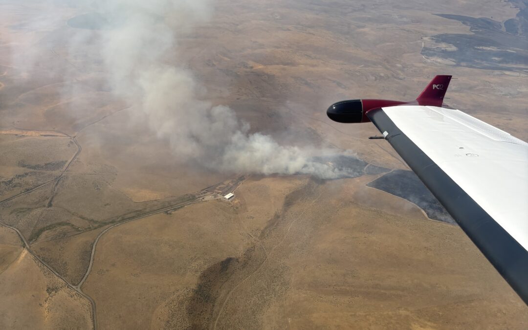
Homeowners returning to the area should expect to see ongoing firefighting activity, including smoke from the fire’s interior. Smoke plumes will continue to be visible within the entire interior of the fire footprint. Structural and wildland crews are on the line 24 hours a day, focusing on strengthening containment lines and reducing hazards.
Evacuations:
Evacuations are managed by the Deschutes County Sheriff’s Office and the Jefferson County Sheriff’s Office.
Level 1, 2, and 3 evacuations remain in effect under the direction of the Deschutes County Sheriff’s Office and the Jefferson County Sheriff’s Office. Follow their Facebook pages for the latest information and updates. They can also be reached by phone: Deschutes County Sheriff’s Office at (541) 388-6655, and Jefferson County Sheriff’s Office (541) 475-6520.
A 24-hour evacuation shelter has been set up by the Red Cross at Highland Baptist Church located at: 3100 SW Highland Ave, Redmond, OR. Jefferson County Fairgrounds in Madras and Kerley Horse Center in Powell Butte are available for large animals.
Local Area closures: To help fire operations and firefighter safety, the Bureau of Land Management and U.S. Forest Service ask that people stay out of the fire area.
The BLM has implemented closures, which can be found under the Prineville tab on the following page: https://www.blm.gov/programs/public-safety-and-fire/fire-and-aviation/regional-info/oregon-washington/fire-restrictions.
The U.S. Forest Service has implemented closures, which can be found on the following page: https://www.fs.usda.gov/r06/deschutes/alerts
As a reminder, drone use near fires is both illegal and extremely dangerous to pilots working on incidents. If you fly, we can’t. FAA Temporary Flight Restrictions are in place for the fire area. All illegal drone use will be reported to law enforcement.
Local Road closures: The Deschutes County Sheriff is managing several local road closures.
· Wilt Road is open from Camp Polk to Buffalo Drive
· Wilt Road is closed at Buffalo Drive
· Mountain View Drive is closed beyond the 17700 block
· Panoramic Drive is closed at Camp Polk Road
· Goodrich Road closed north of Hwy 126
· Holmes Road closed north of Fadjur Lane
Smoke Report: The current smoke outlook for Central Oregon can be found on the following page: https://outlooks.wildlandfiresmoke.net/outlook/6436a95d?