JACKSON & JOSEPHINE COUNTIES, Ore. (July 14, 2025)—Today crews were seeking out and cooling hot spots that were identified overnight from an infrared (IR) flight and PALM IR. Fires showed minimal fire activity along incident perimeters, allowing crews to focus on hazard tree removal and mopping up.
Many of the fires have a large number of dead trees, known as hazard trees or snags, that require extra mitigation to reduce safety risks. Today, crews completed hazard tree removal along roads within the Neil Creek Road and Jim Me Peak fires, allowing easier access for water tenders.
Oregon Department of Forestry Complex Incident Management Team 3 is in command of a group of lightning fires known as the Grizzly Complex that started on Monday, July 7. The ODF Southwest Oregon District continues suppression efforts on additional fires within the district. Resources remain available to respond to new fire starts within the complex area.
Jackson County Sheriff’s Office reduced the Level 2 – Be Set evacuation notices for zones JAC-542, JAC-543, JAC-546, JAC-558 and JAC-559 to a Level 1 – Be Ready notice. Zone JAC-536 remains at a Level 1. More information on current evacuations can be found at: https://protect.genasys.com/. One lane of Interstate 5 is closed to protect firefighters between mile markers 8.5 and 10.5 on southbound lanes only. Check tripcheck.com for up-to-date traffic information.
Aircraft continues to be used throughout the Complex. As a reminder, drone use around fires is illegal, and incredibly dangerous to pilots working on incidents; if you fly, we can’t. All illegal drone use will be reported to law enforcement.
Temperatures are expected to remain at or near triple digits this week, which will naturally increase fire activity and risk. While resources remain engaged on these lightning-caused incidents, communities can help to prevent new fires from starting by following all current fire regulations, found here: https://swofire.com/public-fire-restrictions/.
For fire local information anytime, visit the district’s Facebook page, @ODFSouthwest or website, www.swofire.com.
Current status of the fires under ODF CIMT3 Incident Management:
All Fires are 100% lined and in various stages of mop up. Crews are focusing on removing snags, strengthening lines and extinguishing hot spots along fire perimeters.
Incident Status Summary
Fire
Area in Acres
% Containment
Current Fire Status
Anderson Ridge
0.1
90%
100% lined, in patrol status
Ben Johnson Mtn
3.8
75%
100% lined, in mop up
Benson Gulch
9.8
75%
100% lined, in mop up
Boaz Gulch
0.1
90%
100% lined, in patrol status
Burnt Butte
0.6
90%
100% lined, in patrol status
Cedar Flat
6.3
75%
100% lined, in mop up
Deming Gulch
258
75%
100% lined, in mop up
Grouse Creek Rd
11.1
75%
100% lined, in mop up
Hinkley Gulch Rd
0.5
90%
100% lined, in patrol status
Holcomb Peak
35.5
30%
100% lined, in mop up
Jim Me Peak
142.5
20%
100% lined, in mop up
Lick Creek
0.3
90%
100% lined, in patrol status
Lick Gulch
0.5
90%
100% lined, in patrol status
Munger
0.3
90%
100% lined, in patrol status
Neil Creek Rd
250.4
20%
100% lined, in mop up
N Fork Deer Creek
82.3
30%
100% lined, in mop up
Palmer Peak
76.6
20%
100% lined, in mop up
Sulphur Spring
38
20%
100% lined, in mop up
Tallowbox
1
90%
100% lined, in patrol status
Wagner Creek Rd MM4
0.1
90%
100% lined, in patrol status
Watergap Rd 16495
0.1
90%
100% lined, in patrol status
Waters Gulch
5.6
75%
100% lined, in mop up
The following fires are managed by the ODF District:
Team 3 is in command of several lightning fires in the Southwest Oregon District. Follow the district’s Facebook page for updates.
Team 1 is in command of the Elk Fire (Klamath-Lake District). Follow the incident’s Facebook page for updates.
Team 2 is on rotation.
ODF Priority Fires
FIRE NAME
TOTAL ACRES
ODF ACRES
CONTAINMENT
LOCATION
COMMAND
SWO Lightning Fires
923
923
38%
Jackson and Josephine County
ODF IMT 3
Elk
2,699
848
22%
7 miles SW of Beatty
ODF IMT 1
Highland
719
151
5%
1 mile S of Prineville
Type 3 Team
Willow
4,403
TBD
30%
20 miles S of Paulina
Type 3 Team
Long Point
349
349
86%
8 miles E of Spray
Type 3 Team
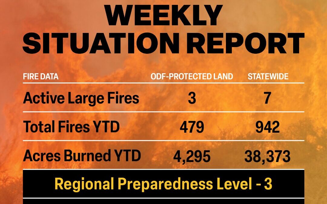
There are approximately 3,124 personnel assigned to the 7 large fires across the state, not including many of the local and agency government employees, landowners, forestland operators, and members of the community who are contributing every day.
Initial attack remains ODF’s top priority to keep wildfires small.
ODF Highlight: We talk a lot about building line and mopping up – but what does that mean exactly? Check out this video from the ODF Southwest Oregon District to learn more about fire terms, the work we’re doing and the why behind it.
Weather: Hot and dry conditions today as low pressure brings very strong north winds to the Okanagan Valley this afternoon and evening. Strong west winds will push through the Cascade gaps into the western Columbia Basin. Expect dry thunderstorms in southeast Oregon and wet storms in far northeast Washington. A notable wind shift will occur across the Basin on Tuesday as high pressure moves in behind the departing low. Some east winds may spill over to the west Cascade foothills, mainly between Mt. Rainier and Mt. Bachelor. A thermal trough will bring instability to southwest Oregon extending up the Oregon Cascade west slopes to the Washington Cascade crest. Winds will ease on Wednesday, but the thermal trough and associated surface instability will remain. West general winds and onshore flow will dominate from Thursday through the weekend, especially through the Cascade gaps. Thunderstorms may return to eastern Oregon and along the Canadian border late next week and next weekend. No significant rain is expected.
Prevention: Check the fire regulations of the areas where you live, work and play, and follow all local restrictions on burning, equipment use, campfires and other activities that can start wildfires. Find danger levels and restrictions across the state here.
BONANZA, Ore. – Fire crews continue working to strengthen the fireline and expanding mop-up into the interior of the fire. Ignition of unburned fuels near the perimeter of the fire continue to ignite, blowing embers outside the control line. Firefighters have been able to quickly address these spot fires, getting them lined and extinguishing all heat. Firefighters will be using strategic firing operations as conditions allow to reduce the unburned fuels within the fire perimeter.
Crews and resources from the Elk Fire supported initial attack efforts in the local area overnight. Today’s weather will continue to test fire control lines, with high temperatures, reduced humidity and increasing afternoon winds.
Today, efforts will focus on extending hoselays, getting water to more areas of the fire and tightening the fireline to the fire’s edge. Firefighters will also be patrolling in the southwestern part of the fire monitoring for any heat or flames.
The size of the fire has been reduced based on better mapping of the fire perimeter and information gathering from firefighters.
The Klamath County Sheriff has implemented evacuations around the fire. For the latest evacuation information, please visit: https://protect.genasys.com/search
A temporary flight restriction remains in place Federal Aviation Administration – Graphic TFRs.
JACKSON & JOSEPHINE COUNTIES, Ore. (July 14, 2025) — Firefighting crews continue mopping-up within fire perimeters, resulting in increased containment of fires across the Grizzly Complex.
Nightshift crews are using handheld infrared cameras to identify hot spots so that day shift can cool and extinguish them.
Personnel working on these fires are facing dry fuels and adverse weather conditions, but must mitigate a number of hazards, including difficult terrain, rolling debris, and standing dead trees, or snags. Crews continue to fall snags to allow firefighters to safely access areas of the fire. The large number of dead fir trees across the region pose a danger to firefighters and can increase the potential for fire spread.
ODF Complex Incident Management Team 3 is in command of a group of lightning fires dubbed the Grizzly Complex that started on Monday, July 7. The ODF Southwest Oregon District continues suppression efforts on additional fires within the district. Incident resources remain available to respond to new fire starts within the complex.
Level 2 – Be Set evacuation notices remain for zones JAC-542, JAC-543, JAC-546, JAC-558 and JAC-559. Zone JAC-536 remains at a Level 1 – Be Ready. More information on current evacuations can be found at: https://protect.genasys.com/. One lane of Interstate 5 is closed to protect firefighters between mile markers 8.5 and 10.5 on southbound lanes only. Visit tripcheck.com for up-to-date traffic information. If conditions change and there are any threats to homes, communities or roads, information will be provided as timely and accurately as possible.
As a reminder, drone use around fires is illegal, and incredibly dangerous to pilots working on incidents; if you fly, we can’t. All illegal drone use will be reported to law enforcement.
High temperatures, low humidity, wind, and dry fuels naturally increase fire danger. While resources remain engaged on these lightning-caused incidents, residents and visitors can help to prevent new fires from starting by following all current fire regulations, found here: https://swofire.com/public-fire-restrictions/.
For fire local information anytime, visit the district’s Facebook page, @ODFSouthwest or website, www.swofire.com.
This will be the last morning update for the incident, unless conditions change. The team will continue to provide evening updates.
Current status of the fires under ODF CIMT3 Incident Management:
All Fires are 100% lined and in various stages of mop up. Crews are focusing on removing snags, strengthening lines and extinguishing hot spots along fire perimeters.
Incident Status Summary
Fire
Area in Acres
% Containment
Current Fire Status
Anderson Ridge
0.1
90
100% lined, in patrol status
Ben Johnson Mtn
3.8
75
100% lined, in mop up
Benson Gulch
9.8
75
100% lined, in mop up
Boaz Gulch
0.1
90
100% lined, in patrol status
Burnt Butte
0.6
90
100% lined, in patrol status
Cedar Flat
6.3
75
100% lined, in mop up
Deming Gulch
258
75
100% lined, in mop up
Gouse Creek Rd
11.1
75
100% lined, in mop up
Hinkley Gulch Rd
0.5
90
100% lined, in patrol status
Holcomb Peak
35.5
30
100% lined, in mop up
Jim Me Peak
142.5
20
100% lined, in mop up
Lick Creek
0.3
90
100% lined, in patrol status
Lick Gulch
0.5
90
100% lined, in patrol status
Munger
0.3
90
100% lined, in patrol status
Neil Creek Rd
250.4
20
100% lined, in mop up
N Fork Deer Creek
82.3
30
100% lined, in mop up
Palmer Peak
76.6
20
100% lined, in mop up
Sulphur Spring
38
20
100% lined, in mop up
Tallowbox
1
90
100% lined, in patrol status
Wagner Creek Rd MM4
0.1
90
100% lined, in patrol status
Watergap Rd 16495
0.1
90
100% lined, in patrol status
Waters Gulch
5.6
75
100% lined, in mop up
The following fires are managed by the ODF District:
JACKSON & JOSEPHINE COUNTIES, Ore. (July 13, 2025) — Despite unfavorable weather conditions, steep slopes, and other challenges, firefighters continue to hold and strengthen fire lines, conduct mop-up within fire perimeters, and increase containment levels of fires across the complex.
Triple digit temperatures, low relative humidity, and winds pose a heightened risk for flaring up hot spots within the fire and generating new starts across the region. Mop-up operations work to cool the fire’s edge to create a wider perimeter to help mitigate embers from escaping the fire.
Today, aircraft delivered large water bladders to remote areas around the fire, enabling crews to extinguish hot spots in difficult-to-access locations. Helicopters also used buckets to cool remote portions of the fire. As a reminder, drone use around fires is illegal, and incredibly dangerous to pilots working on incidents; if you fly, we can’t. All illegal drone use will be reported to law enforcement.
Firefighters continue to fall snags, a common term for dead standing trees, to remove the hazard and allow firefighters to safely access additional portions of the fire.
ODF Complex Incident Management Team 3 is in command of a group of lightning fires dubbed the Grizzly Complex that started on Monday, July 7. Southwest Oregon District continues suppression efforts on additional fires within the district. Grizzly Complex resources remain available to respond to potential new fire starts within the complex.
The Jackson County Sheriff’s Office canceled the Level 1 Evacuation Notice for Zones JAC-325B and JAC-326 today due to progress on the Heppsie Mountain and Poole Hill fires. Level 2 – Be Set evacuation notices remain for zones JAC-542, JAC-543, JAC-546, JAC-558 and JAC-559. Zone JAC-536 remains at a Level 1 – Be Ready. More information on current evacuations can be found at: https://protect.genasys.com/. One lane of I-5 is closed to protect firefighters between mile markers 8.5 and 10.5 on southbound lanes only. Check tripcheck.com for up-to-date traffic information. If conditions change and there are any threats to homes, communities or roads, information will be provided as timely and accurately as possible.
High temperatures, low humidity, wind, and dry fuels naturally increase fire activity. While resources remain engaged on these lightning-caused incidents, residents and visitors can help to prevent new fires from starting by following all current fire regulations, found here: https://swofire.com/public-fire-restrictions/.
For fire local information anytime, visit the district’s Facebook page, @ODFSouthwest or website, www.swofire.com.