ODF Incident Management Teams
- Team 3 is in command of several lightning fires in the Southwest Oregon District. Follow the district’s Facebook page for updates.
- Team 1 is in command of the Elk Fire (Klamath-Lake District). Follow the incident’s Facebook page for updates.
- Team 2 is on rotation.
ODF Priority Fires
| FIRE NAME | TOTAL ACRES | ODF ACRES | CONTAINMENT | LOCATION | COMMAND |
| SWO Lightning Fires | 923 | 923 | 38% | Jackson and Josephine County | ODF IMT 3 |
| Elk | 2,699 | 848 | 22% | 7 miles SW of Beatty | ODF IMT 1 |
| Highland | 719 | 151 | 5% | 1 mile S of Prineville | Type 3 Team |
| Willow | 4,403 | TBD | 30% | 20 miles S of Paulina | Type 3 Team |
| Long Point | 349 | 349 | 86% | 8 miles E of Spray | Type 3 Team |
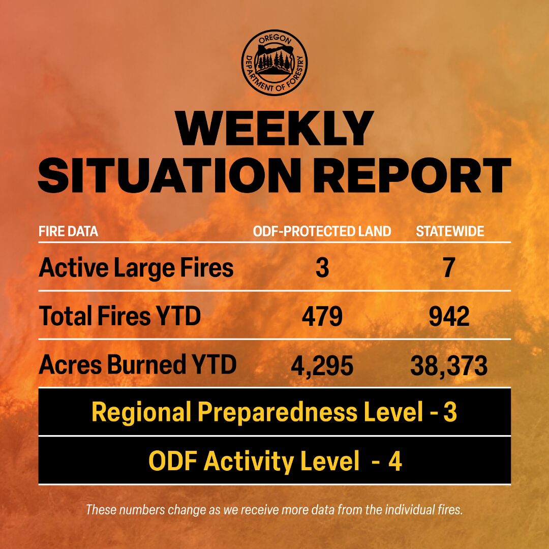
There are approximately 3,124 personnel assigned to the 7 large fires across the state, not including many of the local and agency government employees, landowners, forestland operators, and members of the community who are contributing every day.
Initial attack remains ODF’s top priority to keep wildfires small.
ODF Highlight: We talk a lot about building line and mopping up – but what does that mean exactly? Check out this video from the ODF Southwest Oregon District to learn more about fire terms, the work we’re doing and the why behind it.
Weather: Hot and dry conditions today as low pressure brings very strong north winds to the Okanagan Valley this afternoon and evening. Strong west winds will push through the Cascade gaps into the western Columbia Basin. Expect dry thunderstorms in southeast Oregon and wet storms in far northeast Washington. A notable wind shift will occur across the Basin on Tuesday as high pressure moves in behind the departing low. Some east winds may spill over to the west Cascade foothills, mainly between Mt. Rainier and Mt. Bachelor. A thermal trough will bring instability to southwest Oregon extending up the Oregon Cascade west slopes to the Washington Cascade crest. Winds will ease on Wednesday, but the thermal trough and associated surface instability will remain. West general winds and onshore flow will dominate from Thursday through the weekend, especially through the Cascade gaps. Thunderstorms may return to eastern Oregon and along the Canadian border late next week and next weekend. No significant rain is expected.
Prevention: Check the fire regulations of the areas where you live, work and play, and follow all local restrictions on burning, equipment use, campfires and other activities that can start wildfires. Find danger levels and restrictions across the state here.
Resources
- ODF wildfire blog and Public Fire Restrictions/Danger Levels map
- Regional situation report and national situation report
- Inciweb (information, photos, videos, and maps from specific incidents)

