ODF incident management teams:
- Team 1 is in command of the Battle Mountain Complex – Zone 1 and Courtrock fire near Monument (ODF Central Oregon District). Updates available on the incident’s Facebook page.
- Team 3 is in command of the Battle Mountain Complex – Zone 2 near Ukiah (ODF Northeast Oregon District). Governor Kotek has invoked the Emergency Conflagration Act for this fire. Updates available on the incident’s Facebook page.
- North Carolina Forest Service Complex Incident Management Team (CIMT) is in command of the Cottage Grove Complex (ODF South Cascade District). Updates available on the incident’s Facebook page. This team was ordered in by ODF through a state-to-state mutual aid agreement.
- Team 2 is currently on rotation.
ODF Priority Fires:
| FIRE NAME | ACRES BURNED (est. acres) | CONTAINMENT | LOCATION | COMMAND |
| Courtrock | 9,915 | 3% | 7 miles South of Monument | ODF IMT 1 |
| Battle Mountain Complex | 73,988 | 5% | West of Ukiah | ODF IMT 3 |
| Cottage Grove – Lane 1 Fires | 4,620 | Lane 1 at 10%
All others at 0% |
East of Cottage Grove | NC CIMT |
| Lone Rock | 134,752 | 40% | 10 miles SE of Condon | NW Team 2/OSFM Red Team |
| Durkee | 268,492 | 0% | 5 miles SW of Durkee | NW Team 6/OSFM Green Team |
| Falls | 140,422 | 50% | 20 miles NW of Burns | NW Team 8/OSFM Blue Team |
| Whisky Creek | 288 | 0% | 6 miles SE of Cascade Locks | GB Team 6 |
| Microwave | 704 | 14% | 5 miles SW of Mosier | GB Team 6 |
| Telephone | 9,000 | 0% | 16 miles N of Burns | NW Team 8 |
| Pyramid | 615 | 0% | 15 miles S of Detroit | CA IMT 5 |
| Slate | 50 | 0% | S of the Detroit Resevoir | CA IMT 5 |
| Crazy Creek | 10,000 | 0% | 16 miles E of Paulina | ICT 3 |
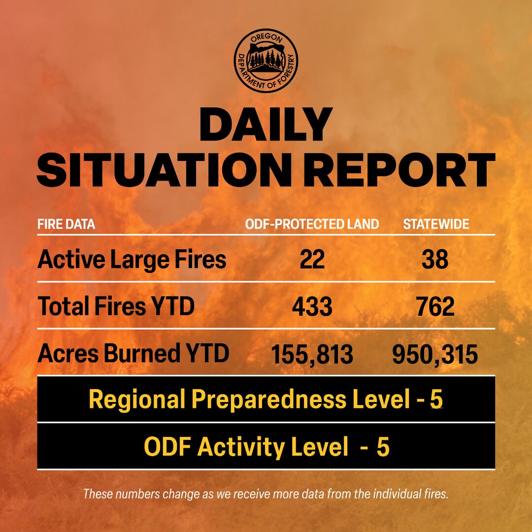
There are approximately 6,774 personnel assigned to the 38 large fires across the state, not including many of the local and agency government employees, landowners, forestland operators, and members of the community who are contributing every day.
Overnight on the Battle Mountain Complex, the Boneyard Fire merged into the Monkey Creek Fire, and will now only be referred to as the Monkey Creek Fire. Fire officials split the Battle Mountain Complex into two zones, with ODF Team 1 managing the west portion of the complex and ODF Team 3 managing the east. Zones are used for effective management and resource allocation.

Agency Highlight: Rangeland Fire Protection Associations (RFPAs) are independent, non-profit, volunteer fire organizations that provide local fire protection in rural Oregon, usually in areas outside of local fire district
protection. There are 28 RFPAs that protect 17.5 million acres of rangeland and are an integral part of Oregon’s complete and coordinated system.
RFPAs are usually some of the first resources to respond and begin work on a fire while more resources are on their way. Recently, the Burnt River Rangeland Fire Protection Association was the first to respond the Thompson, Durkee and Huntington fires the week before, providing invaluable support for initial attack.
Four RFPAs in Harney County—Lone Pine, North Harney, Crane and Silver Creek— have all provided resources to the Falls, Telephone, Ritter and Cow Creek fires, but also helped evacuate cattle from threatened private and federal lands in the early stages of the fire. Lookout-Glasgow, Keating, and Vale RFPAs have also contributed greatly to firefighting operations in both Malheur and Baker counties.
ODF supports the associations through administrative guidance, insurance reimbursement, fire suppression training and facilitating access to federal grants and surplus firefighting equipment.
What to expect this week
Weather: Winds will decrease today over most areas east of the Cascades except for southeast Oregon. Temperatures and humidity will begin moderating as winds fall off further on Friday and over the weekend. Thunderstorms will move east of the area on Thursday through the weekend.
Prevention: Even the smallest of sparks could start the next wildfire. Now more than ever we need Oregonians to prevent human-caused fires and not bring fire hazards onto the landscape. By having fewer human-caused fires, our resources can focus on detecting, assessing and suppressing new fires and putting out the current large fires.
Please, know the fire danger level of the areas where you live, work and play, and follow all local restrictions on burning, equipment use, campfires and other activities that can start wildfires. Find danger levels and restrictions across the state here.
Resources
- ODF wildfire blog and Public Fire Restrictions/Danger Levels map
- Regional situation report and national situation report
- Inciweb (information, photos, videos, and maps from specific incidents)

